| Hills of Dedham, Mass. |
| | Hills | More about Dedham's USGS-listed hills | Maps | Sources | |
| East Dedham Hill |
|
| Federal Hill |
| • |
Google Maps | Google Earth - Google |
| • |
"...Skinner replaced his house on Lowder Street, known as Federal Hill Farm, with a new grand country manor house...", DHS Newsletter, Sept. 2015 (PDF) - Dedham Historical Society & Museum |
| • |
"...Federal Hill, is a beautiful eminence rising from the meadows at the southerly part of the village, commanding an extensive view of the village plain and the scenery beyond....", Mann, pg. 128 , 1847 - Internet Archive |
| • |
"..In 1893, the large red farmhouse known locally as “Federal Hill Farm” on Highland Street in Dedham became home to twenty-four year old Francis Skinner, Jr. The son of two prominent families, including some of the most well-known names in Massachusetts history (the Gardners, Peabodys and Lowells on his mother’s side), he called himself a 'gentleman farmer.'....", The Story of the Ursuline Convent (PDF), Servian Magazine, Elaine Fazekas, 2015 - Ursuline Academy |
|
| Greenlodge Hill |
| • |
Google Maps | Google Earth - Google |
| • |
"...followed from Spragues Pond south around the base of Greenlodge hill...", Dedham, MHC Reconnaissance Survey Town Report (PDF), 1981 - Massachusetts Historical Commission |
| • |
"...Green Lodge, is a fertile tract of land, pleasantly situated in the southeast part of the town, adjacent to Neponset river and the railroad from Boston to Providence. A number of valuable and productive farms are situated here....", Mann, pg. 123 , 1847 - Internet Archive |
|
| Ridge Hill |
| • |
"...Ridge Hill, is a remarkable range of elevated land, commencing near the westerly part of Wigwam pond and running south-easterly through the entire length of Wigwam swamp, a distance of about one mile and a quarter, to the old "country road"... The height of this gravelly ridge is some fifteen to twenty feet above the level of the adjacent sw its width, from three to six rods....", Mann, pg. 122 , 1847 - Internet Archive |
|
| Walnut Hill |
|
| Wilson Mountain |
| • |
USGS identified - MassMapper MassGIS |
| • |
Google Maps | Google Earth - Google |
| • |
Wilson Mountain Reservation, "... Called “ye wilderness” on old Dedham maps, Wilson Mountain Reservation is 207 acres of wild and varied terrain...A deed search traced ownership of the property back to John Wilson in 1742. Wilson, a farmer and the property namesake, probably used the land to harvest trees and graze livestock. Too hilly in some parts and too wet in others to build or actively farm, Wilson Mountain today is an interlocking puzzle of habitats for a wide variety of animals and plants...." - Best Scenic Vistas |
| • |
"... The earliest record we have of Henry Wilson is his admission to the church in Dedham, on the 6th day of the 1st month of 1640....", Descendants of Henry Wilson of Dedham, Massachusetts, pg. 1, Ken Stevens, 1996 - Internet Archive |
| • |
"... John Wilson born at Dedham, Massachusetts, 30 May 1702, youngest of the six children of Ephraim and Rebecca (Sumner) Wilson. He died at Dedham, 1 May 1788, age 86 years....", Descendants of Henry Wilson of Dedham, Massachusetts, pg. 21, Ken Stevens, 1996 - Internet Archive |
| • |
"... The surface is very broken, consisting of swamps, slopes, uplands, and rocky ledges developing into a hill at Wilson's Mountain, with an occasional cleared pasture or meadow....", Dedham Historical Register, Vol. 2, pg. 2, 1891 - Internet Archive |
| • |
Wilson Mountain, Hiking & Walking Trails - Dedham Trails |
| • |
Wilson Mountain - USGS Geographic Names Information System |
|
|
|
|
|
| More about Dedham's USGS-listed hills |
|
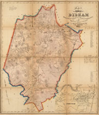
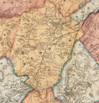
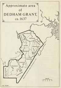
Dedham, Mass. was the second of the first two towns established inland from the coast by the Boston General Court in 1636. Concord was the first. The original boundaries of Dedham stretched along the Charles River all the way to the Rhode Island border. Over time, towns would break away resulting in the separation of Medfield (1651), Wrentham (1673), Needham (1711), Walpole (1724), Dover (1784), Norwood (1872), and Westwood (1897). Several of these towns later subdivided themselves. |
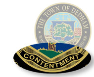 The first settlers wanted to name their new town Contentment, but the General Court had other ideas and gave it the name Dedham. The reason most often given is that some of the new settlers were from Dedham, England. But, according to a 1902 Dedham Historical Register article, “No positively conclusive evidence exists for the choice of Dedham as a name.”1 The original name the people wanted wasn’t forgotten when, 242 years later, a town seal was adopted with the word Contentment incorporated into the design.2 The first settlers wanted to name their new town Contentment, but the General Court had other ideas and gave it the name Dedham. The reason most often given is that some of the new settlers were from Dedham, England. But, according to a 1902 Dedham Historical Register article, “No positively conclusive evidence exists for the choice of Dedham as a name.”1 The original name the people wanted wasn’t forgotten when, 242 years later, a town seal was adopted with the word Contentment incorporated into the design.2 |
| Dedham has one USGS-listed summit, Wilson Mountain (279 ft.). The Wilsons in Dedham date to 1640 when Henry Wilson took the Freeman’s Oath there. He was granted a small parcel of land, but settled on an additional 17 acres of "upland ground fit for improuement with the plaugh" he received in 1643.3 The farm is located in what would become Dover, and Wilson was its first settler. The naming of Wilson Mountain dates to a 1742 deed of John Wilson, Henry’s grandson. |
|
|
| Dedham Sources |
| • |
A History of Dedham, Massachusetts, Frank Smith, 1936 - Hathitrust |
| • |
The History of Dedham from the beginning of its Settlement in September 1635 to May 1827, Erastus Worthington, 1827 - Internet Archive |
| • |
Historical Annals of Dedham from its Settlement in 1635 to 1847, Herman Mann, 1847 - Internet Archive |
| • |
Dedham, History of Norfolk County, Massachusetts, 1622-1918, Louis A. Cook, Vol. 1, 1918 - Internet Archive |
| • |
Dedham, History of Norfolk County, Massachusetts, with Biographical Sketches of Many of its Pioneers and Prominent Men, Duane Hurd, 1884 - Internet Archive |
| • |
Dedham Historical Register, 1890-1903 - Internet Archive |
| • |
History and Directory of Dedham, Mass. for 1889, A.E. Foss & Co., 1889 - Internet Archive |
| • |
A New England Town, The First Hundred Years, Dedham, Massachusetts, 1636-1736, Kenneth A. Lockridge, 1970 - Internet Archive |
| • |
Dedham Historical Society and Museum |
| • |
Dedham, MHC Reconnaissance Survey Town Report (PDF), 1981 - Massachusetts Historical Commission |
| • |
Town of Dedham Open Space & Recreation Plan (PDF), 2010 - Town of Dedham |
|
|
| Footnotes |
| 1 |
Dedham, England. pg. 5, The Dedham Historical Register, Oscar F. Adams, 1902 - Internet Archive |
| 2 |
The Town Seal, pg. 132, Cook, 1918 - Internet Archive |
| 3 |
Smith, pg. 13, Smith, 1936 - Internet Archive |
|
|