| Roxbury was one of the first towns founded in the Massachusetts Bay Colony in 1630, and became a city in 1846 until annexed to Boston in 1868. The land encompassing colonial Roxbury included the Boston Neck (also called Roxbury Neck), and the villages that would become Jamaica Plain, West Roxbury and Roslindale. The area is named for the outcroppings of pudding stone, and originally named Rocksberry. |
|
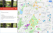
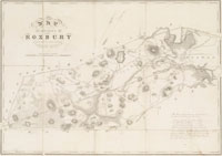
| Hills of Roxbury - Boston, Mass. |
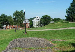
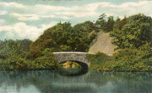
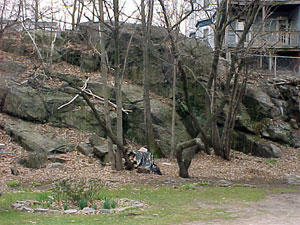
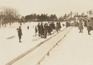
| Bear Cage Hill |
| • |
Google Maps | Google Earth - Google |
| • |
Franklin Park, "...while the Bear Cage loop climbs the fairly significant Bear Cage Hill...." - Wikipedia |
| • |
"...The old bear dens, built in 1912 when the Woods was part of the Zoo, still stand at the edge of Rock Hill overlooking Seaver Street...", Two Walking Tours of Frankin Park, pg. 24, Richard Heath, Franklin Park Coalition - Internet Archive |
| • |
"...The cages are best found by taking a short path into the woods from the east side of the stadium. A wide stone staircase rises to a cleared area with two of the cages..", Meditations on Franklin Park: Bear Cages, 2013 - Mathew Nash, Franklin Park Archive |
|
| Canterbury Hill |
| • |
Google Maps | Google Earth - Google |
| • |
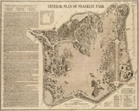
General Plan of Franklin Park, Frederick L. Olmsted, John C. Olmsted, 1885 - Norman B. Leventhal Map Center, Boston Public Library |
| • |
"...Canterbury, that quiet and obscure portion of the town adjoining Dorchester, whose name is a puzzle to the antiquary, and in which are now included the beautiful cemeteries of Forest Hills and Mount Hope ..". Winsor, vol. 3, pg. 572 , 1881 - Internet Archive |
|
| Dudley Cliffs |
| • |
Google Maps | Street View | Google Earth - Google |
| • |
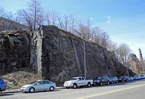
"...A 75-foot-high mass of Roxbury puddingstone starkly reveals what makes up the Fort Hill drumlin and the rock foundation of The First Church and of Jeep Jones Park...Forty feet of the cliffs were blasted out for the new road, leaving the sheer face of rock that is so dramatic today.....", Boston Urban Wilds Report, pg. 59 , - Internet Archive |
| • |
Jeep Jones Park - Wikipedia |
|
| Elm Hill |
| • |
Google Maps | Google Earth - Google |
| • |
"...This estate, 'Elm Hill,' was for a long time the residence of the late John D. W. Williams, but is now (1881) laid out into streets and cut up into house lots....", Winsor, pg. 623, - Internet Archive |
| • |
"...The approach to Elm Hill, formerly the residence of Mr. Rufus Greene Amory, now that of Mrs. J.D.W. Williams, is through a lane bordered by large elm-trees, one of which, at a distance of twelve feet from the ground, is twenty-five feet in circumference ..". Drake, pg. 221 , 1908 - HathiTrust |
| • |
Elm Hill Park Historic District,"...Chisholm Park, later changed to Elm Hill Park in 1905, can be seen on the 1901 survey plan...." - Massachusetts Historical Commission Information System (MACRIS) |
|
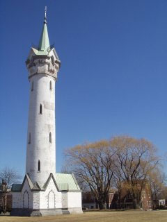
| Fort Hill |
| • |
Google Maps | Google Earth - Google |
| • |
Roxbury During the Siege of Boston, "...Fort Hill, of course, played a major role in these defenses with the upper and lower forts guarding the only land route into Boston along Boston Neck...." - Fort Hill History |
| • |
Fort Hill, "...Fort Hill is actually named after an earthwork fortification that the patriot army built upon the hill located at the center of the neighborhood. The hill is now the location of Highland Park..." - Wikipedia |
| • |
Fort High Fort, "...The Roxbury High Fort site once contained earthwork fortifications of the Continental Army during the Siege of Boston during the American Revolutionary War..." - Wikipedia |
|
| Grotons Hill |
| • |
Google Maps | Google Earth - Google |
| • |
"...The rising ground near Montrose Avenue was once known as Gorton's Hill, from John Gorton, an early resident here, who in 1653 had leave from the town 'to brew and sell penny beare and cakes and white bread.' His estate of six acres was called the 'Wolf Trap.' The area now included in Montrose and Forest Avenues was known later as Warren's Pasture ..". Drake, pg. 219 , 1908 - HathiTrust |
|
| Hagborne Hill |
| • |
Google Maps | Google Earth - Google |
| • |
Forest Hills and the Bell Bequest to Roxbury Latin School, "...[Samuel Hagbourne] immigrated in 1637 and was admitted a freeman on May 2, 1638. He was a wealthy man who owned great tracts of land about Roxbury Neck in the area of present-day Madison Park...In his will Hagbourne granted this land to his youngest daughter. It is today the Wilderness section of Franklin Park, and Hagbourne Hill commemorates the name of the first benefactor of the Free School at Roxbury..." - Jamaica Plain Historical Society |
| • |
"...But the walks north of the drive, between Hagbourne Hill & Ellicott Arch should be completed this Fall if possible..." [Olmsted letter dated Oct. 27, 1890 - The Frederick Law Olmsted Papers Project], Meditations on Franklin Park: Olmsted Letters & Hagbourne Hill, 2013 - Mathew Nash, Franklin Park Archive |
| • |
General Plan of Franklin Park, Frederick L. Olmsted, John C. Olmsted, 1885 - Norman B. Leventhal Map Center, Boston Public Library |
|
| Honeysuckle Hill |
| • |
Google Maps | Google Earth - Google |
| • |
Malcom X. Park, "...Malcolm X Park, also know as Washington Park, is one of Roxbury’s largest and most programmed recreational parks. The original 10-acre park, known as Honeysuckle Hill, was built in 1867...", Kenya Thompson - The Landscape Architect's Guide to Boston |
|
| Juniper Hill |
|
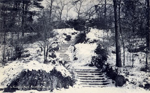
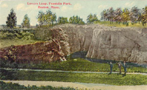
| Lovers Leap |
|
| Lower Fort |
| • |
Google Maps | Google Earth - Google |
| • |
Roxbury During the Siege of Boston, "...Fort Hill, of course, played a major role in these defenses with the upper and lower forts guarding the only land route into Boston along Boston Neck...." - Fort Hill History |
| • |
"...In 1824 this 'lower fort,' so called to distinguish it from the one built to the south of it, was thus described: 'Its interior occupies about two acres of ground, and as the hill
is bare of soil the places may still be seen where the earth was taken to form the ramparts' ..". Drake, pg. 373, 1908 - HathiTrust |
| • |
Alvah Kittredge House,"...His mansion was constructed on the site of the Roxbury Lower Fort on what is now Highland, Linwood and Cedar Streets. The Lower Fort, erected in the summer of 1775, was a companion to the High Fort, built in the same year in the location of the present Highland Park...." - Massachusetts Historical Commission Information System (MACRIS) |
|
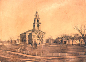
| Meetinghouse Hill |
| • |
Google Maps | Google Earth - Google |
| • |
First Church in Roxbury, "...The fourth meeting house on the site bore witness to the Revolutionary War and, sitting as it did on the strategically important “Meetinghouse Hill,” became the center of a great deal of activity..." - Unitarian Universalist Urban Ministry |
|
| Puddingstone Garden |
|
| Refectory Hill |
|
| Rock Milton |
| • |
Google Maps | Google Earth - Google |
| • |
Atlas of Dorchester, West Roxbury, and Brighton, West Roxbury, Plate 17, L.J. Richards, 1899 - State Library of Massachusetts |
| • |
"...In the map (which is circa 1899) we see that the rocky area north of the pond is labeled Rock Milton, and the broader rocky area to the south is Rock Morton..", Meditations on Franklin Park: Mystery of The Lover’s Leap, 2013 - Mathew Nash, Franklin Park Archive |
|
| Rock Morton |
| • |
Google Maps | Google Earth - Google |
| • |
Atlas of Dorchester, West Roxbury, and Brighton, West Roxbury, Plate 17, L.J. Richards, 1899 - State Library of Massachusetts |
| • |
"...In the map (which is circa 1899) we see that the rocky area north of the pond is labeled Rock Milton, and the broader rocky area to the south is Rock Morton...", Meditations on Franklin Park: Mystery of The Lover’s Leap, 2013 - Mathew Nash, Franklin Park Archive |
|
| Rockledge |
|
| Scarboro Hill |
| • |
USGS identified- MassMapper MassGIS |
| • |
Google Maps | Google Earth - Google |
| • |
General Plan of Franklin Park, Frederick L. Olmsted, John C. Olmsted, 1885 - Norman B. Leventhal Map Center, Boston Public Library |
| • |
"...Among the early Roxbury names, now extinct here, is this of Scarborough. It is, however, kept in remembrance as the name given to the street leading from the corner of the
avenue, where the estate originally was, to Morton Street. John Scarborrow, admitted
a freeman in 1640, 'was slaine the 4th of the 9th month 1646, charging a great gunne.' ..". Drake, pg. 229 , 1908 - HathiTrust |
| • |
Scarboro Hill - USGS Geographic Names Information System |
|
| Schoolmaster Hill |
| • |
Google Maps | Google Earth - Google |
| • |
General Plan of Franklin Park, Frederick L. Olmsted, John C. Olmsted, 1885 - Norman B. Leventhal Map Center, Boston Public Library |
| • |
"...“Schoolmaster Hill” was named for Ralph Waldo Emerson, who as a young man, taught school in Roxbury....", Franklin Park, pg. 4, Boston 200 Neighborhood History Series, 1976 - Internet Archive |
| • |
Schoolmaster Hill, "...Schoolmaster Hill is where the leader of the transcendentalist movement, Ralph Waldo Emerson, lived for two years in a small cabin before the park was created..." - Franklin Park Coalition |
|
| St. Monicas |
| • |
Google Maps | Street View | Google Earth - Google |
| • |
St. Monica's, "...This Urban Wild is the cultivated grounds around "Rockledge," the 19th-century estate that famed abolitionist William Lloyd Garrison occupied in his last years. In this century, the house, with a modem addition, has been St. Monica's Nursing Home...The Garrison House sits on a 50-foot-high rolling mass of pudding-stone...", Boston Urban Wilds Report, pg. 63, - Internet Archive |
|
| Tommys Rock |
| • |
Google Maps | Street View | Google Earth - Google |
| • |
"...At the extreme end of the Wild, the rocks become a sheer cliff facing Washington Street. This is Tommy's Rock, named after a freed slave who in the early years of the 19th century opened a stage coach stop on Washington Street...", Boston Urban Wilds Report, pg. 60, - Internet Archive |
| • |
"...To the west of Clewly's lies the locality known as " Tommy's Rock," a rough and stony region, originally the 'Rocky Pasture,' and sufficiently elevated to afford a fine view towards the southwest. Its name was derived from Tom Hommagen, an old negro, who lived near the Swiss cottage on Circuit Street, near Washington. In requital for professional services, Tom bequeathed his body to Dr. Windship, and this delightful memento mori was long the skeleton in the doctor's closet ..". Drake, pg. 225 , 1908 - HathiTrust |
|
| Warren Gardens/Buena Vista |
| • |
Google Maps | Google Earth - Google |
| • |
Warren Gardens, "...Comprised of a 50-foot rock cliff.....", Urban Wilds: Roxbury - City of Boston |
| • |
"...In 1876, Boston dry good merchant Isaac Fenno built a huge mansion on the highest ridge on the grounds and called it Buena Vista...The rocky, wooded outcrop was willed to the City of Boston with a mandate that it remain open as a last vestige of Old Roxbury. The cliffs along Warren Street opposite Whiting are distinctive. The hill, which rises 50 feet above the street, gradually tapers down to Walnut Avenue under a canopy of thickly growing red maple, black locust and black cherry. Near the summit, the jagged puddingstone foundation wall creates a cool grotto.....", Boston Urban Wilds Report, pg. 61, - Internet Archive |
|
|
|
 |
|
 |
|
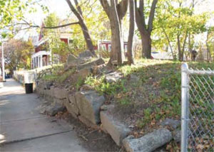
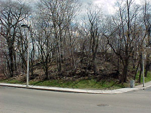
| Dudley Cliffs |
 |
|
| Fort Hill |
 |
|
 |
|
| Hagborne Hill |
 |
|
| Lovers Leap |
 |
|
| Meetinghouse Hill |
 |
|
 |
|
| Refectory Hill |
 |
|
 |
|
 |
|
| Rock Milton |
 |
|
| Rockledge |
 |
|
| Schoolmaster Hill |
 |
|
 |
|
 |
|
| Tommys Rock |
 |
|
| Warren Gardens/Buena Vista |
 |
|
|
| Roxbury Maps |
| • |
Roxbury - Google Maps, Terrain |
| • |
Roxbury - MassMapper MassGIS |
| • |
Roxbury - USGS - The National Map |
| • |
Boston South Quadrangle - 2018 (60 MB PDF) - USGS Topo Download |
| • |
USGS Historical Topographic Map Explorer |
| • |
Map of the Town of Roxbury, Massachusetts, John G. Hales, 1832 - Norman B. Leventhal Map Center, Boston Public Library |
| • |
City of Roxbury, Massachusetts, Charles Whitney, 1849 - Norman B. Leventhal Map Center, Boston Public Library |
| • |
Atlas of Roxbury, Geo. W. & Walter S. Bromley, 1899 - State Library of Massachusetts |
| • |
Atlas of Dorchester, West Roxbury, and Brighton, West Roxbury, Plate 17, L.J. Richards, 1899 - State Library of Massachusetts |
| • |
A Plan of Boston in New England with its Environs, Henry Pelham, 1777 - Library of Congress |
| • |
General Plan of Franklin Park, Frederick L. Olmsted, John C. Olmsted, 1885 - Norman B. Leventhal Map Center, Boston Public Library |
| • |
Plan of Boston and its Vicinity, Showing the Drainage Area of Stony Brook, H.M. Wightman, 1863 - Norman B. Leventhal Map Center, Boston Public Library |
|
|
| Roxbury Sources |
| • |
The History of Roxbury Town, Charles M. Ellis, 1847 - Internet Archive |
| • |
The Town of Roxbury its Memorable Persons and Places, A Volume of Records Relating to the Early History of Boston, Francis S. Drake, Vol. 34, 1908 - HathiTrust |
| • |
The Roxbury Magazine, All Souls Unitarian Church, 1899 - Internet Archive |
| • |
The Memorial History of Boston including Suffolk County, Massachusetts, 1630-1880, Vol. 4 , Justin Winsor, 1881 - Internet Archive |
| • |
Roxbury Historical Society |
| • |
Jamaica Plain Historical Society |
| • |
Franklin Park, a Chapter from 'Boston Parks Guide, Sylvester Baxter, 1896 - Internet Archive |
| • |
1990 Boston Urban Wilds Report, Boston Natural Areas Fund, 1990 - Internet Archive |
| • |
Franklin Park: Images of America, Julie Arrison, 2009 - Google ebook preview |
| • |
Franklin Park, a Chapter from Boston Parks Guide, Sylvester Baxter, 1896, Franklin Park Coalition - Internet Archive |
| • |
Franklin Park, Boston Landmarks Commission Study Report (PDF), 1980 - City of Boston |
| • |
Two Walking Tours of Frankin Park, Richard Heath, Franklin Park Coalition - Internet Archive |
| • |
Franklin Park Coalition |
|
|
|