| Hills of Stoneham, Mass. |
| | Hills | More about Stoneham's USGS-listed hills | Maps | Sources | |
| Bear Hill |
|
| Black Rock |
|
| Cairn Hill |
|
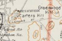
| Carters Hill |
|
| Cobble Hill |
| • |
Google Maps | Google Earth - Google |
| • |
"...The school-house, district number one, was located at the corner of Main Street and Captain Rufus Richardson's Lane; in number two on Cobble Hill, not far from the present standpipe..." - Stevens, pg. 75, 1891 - Internet Archive |
| • |
"...And now we propose that "Cobble Hill " in Stoneham be hereafter styled "Prospect Hill." If rightly informed, its present name became connected with it in the minds of the people in this wise: Some years ago a deranged man, when in a fit of insanity, told his friends that if they wanted any cobbling done to "call at Cobble Hill, No. 20." But we much prefer the name "Prospect Hill," is less homely and more appropriate...", The Winchester Record, pg. 366, Winchester Historical and Genealogical Society, 1885-1887 - HaithiTrust |
|
| Deer Hill |
|
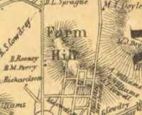
| Farm Hill |
| • |
USGS identified - MassMapper MassGIS |
| • |
Google Maps | Google Earth - Google |
| • |
"...Thomas Gery, probably of Irish ancestry, was born about 1638, ... made a clearing and built a house or cabin just beyond the northern slope of Farm Hill, on or near the present High Street, and had his home there during King Philip's War...." - Hurd, pg. 463, 1890 - Internet Archive |
| • |
"...Early area is isolated settlement from Charlestown by mid-17th century on Farm Hill with Scotch-Irish element.... ", Stoneham, MHC Reconnaissance Survey Town Report (PDF), 1981 - Massachusetts Historical Commission |
| • |
Farm Hill - USGS Geographic Names Information System |
|
| Getys Hill |
|
| Nobility Hill |
| • |
Google Maps | Google Earth - Google |
| • |
Nobility Hill Historic District: "...The Nobility Hill Historic District, Stoneham, Massachusetts is a small, modest residential enclave located a few blocks west of the historic town center...
...This site was selected for residential development in the second half of the 19th century for several reasons. One was the hilltop setting, which offered panoramic views that complemented the picturesque a rchitectural styles of the period. Another was direct proximity to the shops, factories, and institutions of Central Square a few short blocks to the east. A final factor, which became increasingly important, was close proximity to the Lindenwood Railroad Station on Montvale Avenue, which allowed residents to commute to jobs in Boston..."- Massachusetts Historical Commission Information System (MACRIS) |
|
| Rowe Hill |
| • |
Google Maps | Google Earth - Google |
| • |
Perhaps: "...Allen
Rowe, who for many years manufactured shoes in a part of his house, and
subsequently, with his son Allen, Jr., built quite a large factory..." - Stevens, pg. 93, 1891 - Internet Archive |
| • |
Mill Lot Hill, Stoneham, Haywadville Town, F. W. Beers, 1875 - Historic Map Works |
|
| Saddleback Hill |
|
| Pickerel Rock |
|
| Taylor Mountain |
|
| Wamoset Hill |
|
| Wanapanaquin Hill |
|
| Whip Hill |
|
| Winthrop Hill |
|
|
|
 |
|
 |
|
Middlesex Fells
Reservation |
 |
|
| Carters Hill |
 |
|
| Farm Hill |
 |
|
|
|
| More about Stoneham's USGS-listed hills |
|
Stoneham, Mass. has one of only four hills, or hill-like features, in the Boston Basin named by the Puritan leader John Winthrop (1587-1649). This also makes it one of the earliest named hills by the Puritans. In the winter of 1631/1632 Winthrop was confident enough of the new colony’s survival to go exploring, they are barely made it through the previous winter almost running out of food. On February 7th he and a group went up the Mystic River and, with Winthrop writing in the third person, “they came about two or three miles to a very great pond... and the pond had divers small rocks, standing up here and there in it, which they therefore called Spot Pond.”1 Next, “They went all about it upon the ice. From thence (towards the N. W. about half a mile,) they came to the top of a very high rock, beneath which, (towards the N.) lies a goodly plain, part open land, and part woody, from whence there is a fair prospect, but it being then close and rainy, they could see but a small distance. This place they called Cheese Rock, because, when they went to eat somewhat, they had only cheese, (the governor's man forgetting, for haste, to put up some bread).” |
| A nice story, and one would think that over the years someone would have thought of noting such an important object, like Plymouth Rock. Unfortunately, the exact location of Cheese Rock is not known. By almost all it’s been assumed that Winthrop did not mean to name a hill Cheese Rock, rather a rock on a hill that offered a good view to the north. But how did he know it had a good view? He describes it as “close and rainy.” And rainy in February? |
|
If there is one person you would might think would have known the location of Cheese Rock, it would be Elizur Wright (1804-1885). His efforts are most credited with the creation of the Middlesex Fells Reservation, though he thought the name should be Mount Andrew Park.2 This after John A. Andrew (1818-1867), the Massachusetts Governor during the Civil War and ardent abolitionist, as was Wright. In 1880, in his ongoing efforts to promote the creation of the park, Wright wrote a letter to the Boston Globe inviting people to Cheese Rock at the “foot of Mt. Andrew, nee ‘Cheese Rock,’ sometimes called Bear Hill, though it has no bears, and sometimes Bare Hill, though it by no means bare.”3 George E. Davenport (1833-1907), botanist, photographer, and supporter of the park, wrote in 1893 that he was there, “ascending Bear Hill, by way of the cart path, through the rocky meadow we are soon standing on the historic ‘Cheese Rock’ where Gov. Winthrop and party rested and lunched over 260 years ago.”4 Others wrote it might be a ledge on the side of hill, or maybe even a rock at the base of the hill. The Appalachian Mountain Club built a wooden observation deck on the summit in 1893. That was replaced in 1910 by a concrete tower. In 1903 an open reservoir was created on the hill, and then in 1986 it was covered. |
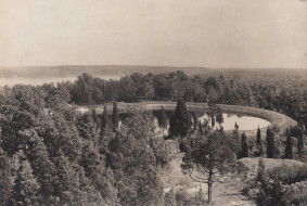
| The USGS doesn’t list Cheese Rock. It does list Bear Hill (305 ft.) and offers Bare Hill as a variant name. Like other Bear/Bare Hills in the Boston Basin, there could have an abundance of bears on just one hill despite there being many hills nearby, or the hill at that time could have had no trees on its summit providing the “fair prospect” Winthrop mentions. Stoneham has eight USGS-listed hills. Six, including Bear Hill, lie within the Middlesex Fells Reservation. The two not in the park are Carters Hill (226 ft.) and Farm Hill (217 ft.). In the mid-1600s the first settlers in what was then called Charlestown End were farmers. The “goodly plain” that Winthrop mentioned was towards the north in the direction of Woburn (incorporated 1642) and Reading (incorporated 1644). The histories written about Stoneham mention farms on the hill, and likely it’s as simple as that. Located on the northern rim of the Boston Basin, the residents of Charlestown End had far more in common with the neighbors in North Reading, South Reading (today’s Wakefield), and Woburn than they did with people on the distant peninsula of Charlestown. In 1725 they were given authority to create their own town and chose the name Stoneham after a town in England. Better transportation routes to Boston became available when the Andover and Medford Turnpike (now Route 28/Main Street) opened in 1806, and then in mid-1850s railroad lines were extended into Stoneham. |
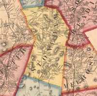
| There is almost no information on the other USGS-listed hill in Stoneham, Carters Hill (226 ft.). It is identified on a map in the 1894 O.W. Walker Atlas of Massachusetts, but there is no mention of it in any the three books on the history of Stoneham; Silas Dean, 1870; William B. Stevens, 1891; or Lemuel W. Standish, 1937. Nor in the 1981 MHC Reconnaissance Survey Town Report or the 1999 book on Stoneham by Joanne B. Harriman. There were members of the Carter family in area. Actually, two different Carter families.5 Thomas Carter (1608-1684) was the first minister in nearby Woburn. Another Thomas Carter (c.1585-1665) was a blacksmith who also lived in Woburn. |
| Along with Bear Hill, there are five other USGS-listed hills that are Stoneham and the Middlesex Fells Reservation. In 1880 Elizur Wright noted, “it will be necessary to have many new names to distinguish particular localities in so extensive a park.” His idea? Sell naming rights, with the highest bidder getting first choice. He wrote, “as there are about as many hills in this 4,000 acres… I propose that the largest subscription should give the right to the first choice of a hill, to which the subscriber may attach a name which shall be recognized on all future maps of the park…”6 It that offer were made today we might have Wayfair Hill and Mount Ernie Boch. Wright’s naming idea was not adopted. A more reasonable approach was implemented as describe by Charles Eliot in 1895, “Attention has been given to the naming of the principal hills, valleys, and streams of the reservations, much study having been directed to discovering the oldest or most generally accepted designations for such places as have been named in times past, as well as to searching for suitable designations for unnamed points of interest. Many names of Indian chieftains have been applied to hills especially.”7 |
| Wamoset Hill (210 ft.) and Wanapanaquin Hill (220 ft.) are two USGS-listed hills in the Stoneham portion of the park with the Native Americans names.8 Wamoset is a variant spelling of Wamesit, the name of both a Native American village and the people who lived there. The village was located at the junction of the Merrimack and Concord rivers, and near the Pawtucket Falls on the Merrimack, a popular for catching migrating fish. It served as a meeting place for Natives Americas living up and down the river. After the arrival of the Puritans it became one of villages established for “Praying Indians,” Native Americans who converted to Christianity. Like many Native American names, there are conflicting translations for the name Wamosit. The most common one is, “here is space for all.” A translation a Puritan leader might favor while trying to convert more Native Americans. Another translation of Wamosit is the more logical, “place where rivers converge.” |
| Wanapanaquin was the name given to three daughters of the Native American Wenepoykin (1616-1684). He was the son of a Native American leader when the Puritans arrived and would eventually become sachem of area stretching from Lynn to Reading to Chelsea. His relationship with colonial authorities would not go well. He first sued unsuccessfully over land lost to settlers, then frustrated joined other Native Americans in an attempt to expel the Puritans during the King Philip’s War (1675-1678). Captured, he was sold into slavery in Barbados. Remarkably he survived and returned home living out the rest of live at the Natick village for Praying Indians. The name Wenepoykin is thought to mean wing or feather, with the daughter’s name Wanapanaquin correspondingly meaning plumed ones. The three would take angelized first names - Petagunsk (Cicely), Wattaquattinusk (Sarah), Petagoonaquah (Susannah)- and move, or be forcibly resettled, to Wamesit. |
| It’s unclear where Whip Hill (259 ft.) got its name. It is not mentioned in any of the early histories of the town, and first appears on an 1895 topographic map of the Middlesex Reservation done by the company French, Bryant & Taylor for the Metropolitan Park Commission. The surveyors must have found someone in the area who said it was called Whip Hill. Adjacent to the Middlesex Fells is a Stoneham town park named Whip Hill Park. It was the private estate of James and Angie Crockett. He was the president of Heveatex, one of the local companies like Converse Rubber (not the shoe company) that were leaders in the manufacturer of latex products from rubber. She ran a business that produced artificial flowers made with latex. They donated the land to the town in 1968. |
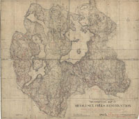
| The naming of Taylor Mountain (239 ft.) and Winthrop Hill (276 ft.) has some twists. The 1856 H.F. Walling map of Middlesex County shows two hills in southern Stoneham, Bare Hill, and just south of it, Tailor Hill. This before there was a Middlesex Fells Reservation. Rosewell B. Lawrence’s 1886 map of the park for Appalachian Mountain Club identifies the two hills as Bear Hill and Taylor Mountain.9 Then when the official French, Bryant & Taylor first topographic map for the park came out in 1895, its Bear Hill and Winthrop Hill.10 A name change is nothing unusual, it coincided with the creation of the park, and while it isn’t what Elizur Wright wanted, at least something in the Middlesex Fells is named for John Winthrop. Remarkably, Taylor Mountain resurfaced, in a slightly different position, on the latest USGS National Map. And like many other slightly unusual naming of hills on the northern border of the Boston Basin, it’s thanks to Alden T. Vaughan and his 1965 book, which doesn’t mention Taylor Mountain. On the latest map, a spur just to the northeast of Winthrop Hill now carries the name Taylor Mountain. What’s not clear is why the hill was named after Tailor, or Taylor, in the first place. |
|
|
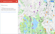
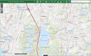
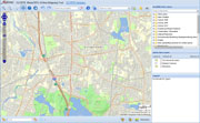
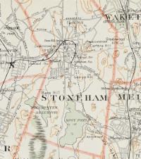
| Stoneham Maps |
| • |
Stoneham - Google Maps, Terrain |
| • |
Stoneham - MassMapper MassGIS |
| • |
Stoneham - USGS - The National Map |
| • |
Boston North Quadrangle - 2018 (60 MB PDF) - USGS Topo Download |
| • |
Reading Quadrangle - 2018 (60 MB PDF) - USGS Topo Download |
| • |
Plan of the Town of Stoneham,John G. Hales, 1830 - Norman B. Leventhal Map Center, Boston Public Library |
| • |
Stoneham, Haywadville Town, F. W. Beers, 1875 - Historic Map Works |
| • |
Atlas of the boundaries of the town of Stoneham, Middlesex County, 1899 - State Library of Massachusetts |
| • |
Atlas of Massachusetts, Plate No. 4, O.W. Walker, 1894 - State Library of Massachusetts |
| • |
Atlas of Middlesex County, Volume 2, Stoneham Maps: 8, 9, Geo. W. Walker & Co., 1906 - State Library of Massachusetts |
| • |
Map of the towns of Wakefield, Stoneham, Reading, North Reading, and Lynnfield, H.T. Whitman, 1907 Norman B. Leventhal Map Center, Boston Public Library |
| • |
Map of Middlesex County, Mass., Henry F. Walling, 1856 - Library of Congress |
| • |
See: Hills of the Middlesex Fells Reservation |
|
|
| Stoneham Sources |
| • |
A Brief History of the Town of Stoneham, Mass. from its First Settlement to the Year 1843, Silas Dean, 1870 - HathiTrust |
| • |
History of Stoneham, Massachusetts, William B. Stevens, 1891 - Internet Archive |
| • |
Stoneham, History of Middlesex County, Massachusetts, with Biographical Sketches of Many of its Pioneers and Prominent Men, Duane Hurd, 1890, Vol. 2 - Internet Archive |
| • |
Stoneham, History of Middlesex County, Massachusetts: Containing Carefully Prepared Histories of Every City and Town in the County, Samuel A. Drake, 1880, Vol. 2 - Internet Archive |
| • |
Vital Records of Stoneham, Massachusetts, to the end of the year 1849, The Essex Institute, 1918 - HathiTrust |
| • |
Stoneham, Massachusetts, the Friendly Town, Lemuel W. Standish, 1937 - HathiTrust |
| • |
Stoneham Historical Society |
| • |
Stoneham Historical Walking Tour - Explore Stoneham |
| • |
Stoneham Historical Chronology (PDF) - Town of Stoneham, Mass |
| • |
Stoneham (PDF), National Register of Historic Places - NPGallery Digital Assestment Management System, National Park Service |
| • |
Stoneham, MHC Reconnaissance Survey Town Report (PDF), 1981 - Massachusetts Historical Commission |
| • |
Stoneham: Images of America, Joanne B. Harriman, 1999 - Google ebook preview |
| • |
See: Hills of the Middlesex Fells Reservation |
|
|
| Footnotes |
| 1 |
Life and letters of John Winthrop, Vol. 2, pg. 104, 1867 - HathiTrust |
| 2 |
Elizur Wright's appeals for the Middlesex Fells, pg. 7, Ellen Wright, 1893 - HathiTrust |
| 3 |
Picnic in the Middlesex Fells (subscription), Elizur Wright, October 14, 1880 - Boston Globe |
| 4 |
A Lecture on the Middlesex Fells, pg. 19, George E. Davenport, 1893 - Internet Archive |
| 5 |
Surname Saturday - Carter of Woburn, Massachusetts, 2013 - Nutfield Genealogy |
|
Thomas Carter the Blacksmith and Mary, 2017 - Every Leaf Has A Story |
| 6 |
Elizur Wright's appeals for the Middlesex Fells, pg. 32 , Ellen Wright, 1893 - HathiTrust |
| 7 |
Charles Eliot, Landscape Architect, pg. 513, Charles W. Eliot, 1902 - HathiTrust |
| 8 |
What Native People Were on Cape Ann at the Time of Contact and Where Did They Come From?, Mary Ellen Lepionka, 2018 - Native Americans of Cape Ann |
|
The First Inhabitants Of Marblehead, Donald A. Doliber - Marblehead Magazine |
| |
Wamesits, Pawtuckets remain alive in the Merrimack Valley, Michael L. Kelley, 2015 - Lowell Sun |
| 9 |
Map of the Middlesex Fells, Rosewell B. Lawrence, Appalachian Mountain Club, 1886 - Havard Library | Googe ebook |
| 10 |
Topographical Map of Middlesex Fells Reservation, French, Bryant & Taylor, Metropolitan Park Commission,1895 - Norman B. Leventhal Map Center, Boston Public Library |
|
|