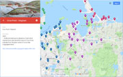
| Hills of Hingham, Mass. |
| | Hills | More about Hingham's USGS-listed hills | Maps | Sources | |
| Baker Hill |
| • |
USGS identified - Oliver MassGIS Online Mapping Tool |
| • |
Google Maps | Google Earth - Google |
| • |
"...After turning into Beal Street, Baker's Hill rises on the right hand. It is one of the largest and highest hills in town, and there is a superb view from the top. It derived its name from the residence, at its foot, of Nicholas Baker, who with his brother Nathaniel came with Rev. Peter Hobart in 1635...", History of Hingham, Vol. 1, pg. 181, 1893 - Internet Archive |
| • |
"...Nicholas and Nathaniel [Baker] came to Hingham in 1635. They were brothers, and when the first house-lots were drawn, Sept. 18, 1635,
they had adjoining lots of five acres each granted to them on Town (North, near Beal) St. Hence the name of the sightly eminence in
that locality known as Baker's Hill...", History of Hingham, Vol. 3, pg. 17, 1893 - Internet Archive |
| • |
"...Nicholas Baker...He received a share in the first division of house lots in Hingham in 1635, as did also Nathaniel Baker. He afterward became an extensive landholder in Hull, and resided there. He seems to have been employed chiefly in agriculture for several years, though a man of more than ordinary qualifications, and often employed in publick affairs...", History of Scituate, Massachusetts, pg. 181, Samuel Deane, 1831 - Internet Archive |
| • |
"Baker Family", Massachusetts Bay Connections, pg. 33 , Judy Jacobson, 2009 - Google ebook preview |
| • |
Baker Hill - USGS Geographic Names Information System |
|
| Black Snake Hill |
| • |
"..The Iron Mine (so called) is here at the corner of the lane, although indistinguishable in the undergrowth. It is hard to say now what gave this name to the locality. Near it is Black Snake Hill...", History of Hingham, Vol. 1, pg. 191, 1893 - Internet Archive |
|
| Bradley Hill |
| • |
USGS identified - MassMapper MassGIS |
| • |
Google Maps | Google Earth - Google |
| • |
Bradley - Glover, C. B. House "...By the end of the nineteenth century, and the start of the twentieth, members of the Bradley family, most prominently Peter and Abbie Bradley, had begun to accumulate a large plot of land in the area of present day 64 Bradley Hill Road. The Bradley family had amassed a considerable fortune through various industrial concerns, including a hotly-debated fertilizer plant that apparently produced powerful odors, and had purchased enough acres in the northern area of Thaxter Street for the area to take on the name of Bradley Hill...", - Massachusetts Cultural Resource Information System (MACRIS) |
| • |
The Forgotten Man, Peter Bradley's Role in Early American Breeding, "...Peter Bradley was an industrialist from the Boston, Massachusetts, area, with business interests in fertilizer, lumber and heavy machinery...His activities as a horse breeder centered around his farm near Hingham, Massachusetts, a farm known to every fan of the earlier Arabian Horse Club stud books as the "Hingham Stock Farm"....", Charles and Jeanne Craver, Arabian Horse World, 1984 - Phil Gyford’s website |
| • |
Bradley Hill - USGS Geographic Names Information System |
|
| Burrs Hill |
| • |
"...Burr's Hill, so called from a Mr. Burr, who owned land at its foot...", History of Hingham, Vol. 1, pg. 191 , 1893 - Internet Archive |
| • |
"...Simon [Burr], who came from Dorchester and settled in Hingham 1647, was the ancestor of all the families who have borne the surname Burr in this town...", History of Hingham, Vol. 3, pg. 100, 1893 - Internet Archive |
|
| Coal Pit Hill |
| • |
"... A short distance beyond this gateway Long-Bridge Lane runs eastward from Union Street, winding through woods to granite quarries, and then crosses Beechwoods River. Near the entrance to this lane is Coal-Pit Hill...", History of Hingham, Vol. 1, pg. 196, 1893 - Internet Archive |
|
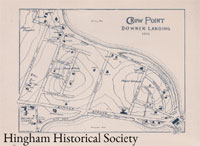
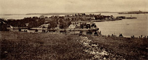
| Crow Point |
|
| Fort Hill |
| • |
Google Maps | Google Earth - Google |
| • |
"...Returning to Beal Street, and crossing the head of the Swamp, over West Street, we turn to the right into Fort-Hill Street, which passes over Fort Hill, about a quarter of a mile farther southwest. The old name was Nichols's Hill, until, in the time of King Philip's War, a fort was built upon it for protection against Indian attacks, and the name was changed to Fort Hill. When the top of the hill was cut off, the lines of the old fort were obliterated...", History of Hingham, Vol. 1, pg. 182, 1893 - Internet Archive |
| • |
Fort Hill District - Massachusetts Cultural Resource Information System (MACRIS) |
|
| Great Hill |
| • |
USGS identified - MassMapper MassGIS |
| • |
Google Maps | Google Earth - Google |
| • |
"...New Bridge Street, which runs in a southerly direction from Fort-Hill Street, crosses Fresh River, passes through Bare Swamp, and skirts the easterly side of Great Hill, which lies between it and Hobart Street...", History of Hingham, Vol. 1, pg. 182 , 1893 - Internet Archive |
| • |
Historic Map of Hingham, Mass. - Hingham Public Library |
| • |
Great Hill - USGS Geographic Names Information System |
|
| Jones Hill |
| • |
Google Maps | Google Earth - Google |
| • |
"...Leavitt Street and Jones Street. Between these two roads on land of Mr. James Jones is a rocky hillock of granite about equidistant from both, in which may be found three trap dikes not far apart, one of which has the considerable width of ten feet...", History of Hingham, Vol. 1, pg. 32, 1893 - Internet Archive |
|
| Mars Hill |
| • |
Google Maps | Google Earth - Google |
| • |
"...At the last bend of North Street is a small hill, a spur of Baker's Hill, known as Mars Hill. One of the oldest houses
in Hingham stands upon it...", History of Hingham, Vol. 1, pg. 181, 1893 - Internet Archive |
| • |
"...The home was placed in its current Mars Hill, a spur of Baker’s Hill, location in 1735...
... In the winter of 1735, frozen marshland caused the owners to move the home from its first plot of land to its current place on Mars Hill...", This Old House Is Literally Older Than the Country Itself, Nov. 24, 2010 - Homes.com |
| • |
"...There is a tradition that the oldest house in Hingham stands on Mars Hill, North Street near Beal Street...", Hingham Opinion: Facts sought on ‘oldest building’, Oct. 11, 2009 - Wicked Local Hingham |
|
| Mount deWolfe |
| • |
Google Maps | Google Earth - Google |
| • |
"...Downer was a true family man. In 1836 he married Nancy de Wolfe Melville, cousin to author Herman Melville, and the couple had eight children together. Within Melville Garden, he named one hill "Mount de Wolfe" for his father-in-law, and another hill became Mount Gertrude for his daughter...", Samuel Downer, Legendary Locals - Hingham Public Library |
| • |
Melville Gardens, Hidden Pleasures, Cathy Corcoran Video - YouTube |
|
| Mount Gertrude |
| • |
Google Maps | Google Earth - Google |
| • |
"...Downer was a true family man. In 1836 he married Nancy de Wolfe Melville, cousin to author Herman Melville, and the couple had eight children together. Within Melville Garden, he named one hill "Mount de Wolfe" for his father-in-law, and another hill became Mount Gertrude for his daughter...", Samuel Downer, Legendary Locals - Hingham Public Library |
| • |
"...After the Civil War he had a better idea of what to do with his Hingham land. Downer developed Crow Point, then called Gertrude Hill after his daughter...", Historic house tour to focus on Crow Point in Hingham, 2016 - Wicked Local Hingham |
| • |
Melville Gardens, Hidden Pleasures, Cathy Corcoran Video - YouTube |
|
| Old Colony Hill |
| • |
Google Maps | Google Earth - Google |
| • |
"...Neck Gate Hill, now Old Colony Hill, at the junction of Rockland Street, Summer Street, and Martin's Lane, is a pleasantly located hill, having fine woodlands and beautiful country about it. The view from the summit in every direction is charming. For many years the Old Colony House, a favorite summer resort, stood here. It was built in 1832, and burned in 1872...", History of Hingham, Vol. 1, pg. 1, 1893 - Internet Archive |
| • |
"...This is the 90-room Old Colony House overlooking Hingham Harbor on Neck Neck Gate Hill we now call it Old Colony Hill...", Hingham Yesterdays: Old Colony House destroyed by fire, Nov. 9, 2016 - Wicked Local Hingham |
|
| Otis Hill |
| • |
USGS identified - MassMapper MassGIS |
| • |
Google Maps | Google Earth - Google |
| • |
"...The hill takes its name from John Otis, an early settler with Rev. Peter Hobart, in 1635, and who received a grant of land here. He was the ancestor of the celebrated Otis family in America...", History of Hingham, Vol. 1, pg. 177, 1893 - Internet Archive |
| • |
"...Broad Cove Lane, now Lincoln Street, from which by a grassy lane Otis Hill - then Weary-all Hill - was reached, was also occupied by
some of the first comers...", Lincoln, pg. 10, 1827 - Internet Archive |
| • |
"...John [Otis], born at Barnstable, in the County of Devonshire, Eng. 1581, probably came to our Hing. with Rev. Peter Hobart and his company, and on the 18th of Sept., 1635, drew a house-lot containing five acres on Town (North, near Ship) St., where he resided until March 15, 1646, when his house, and the one in the adjoining lot, belonging to Thomas Loring, was burnt to the ground...", History of Hingham, Vol. 4, pg. 101, 1893 - Internet Archive |
| • |
"...At one time it was supposed that John arrived with the Rev. Peter Hobart in 1635...It is evident, however, that he settled at Hingham at least as early as 1631...
...
This hill, rarely known, even in early times in Hingham, by its quaint "over the water" name of Weary-All, has permanently become what, even in those times, was known as "Otis Hill." Its general slope and outline, however, is so very like old "Weri-All" as to show why the original name would naturally have been chosen by its first owner..", A Genealogical and Historical Memoir of the Otis Family in America, pg. 39, William A. Otis, 1924 - HathiTrust |
| • |
Otis Hill - USGS Geographic Names Information System |
|
| Pear Tree Hill |
| • |
Google Maps | Google Earth - Google |
| • |
"...These salt marshes, extending south to Pear Tree Hill, are known as the Home Meadows...", History of Hingham, Vol. 1, pg. 175, 1893 - Internet Archive |
| • |
"...This house on Pear Tree Hill at #255 Main Street was built for Levi Leavitt in 1783. In 1891 it was torn down and William J. Nelson built a dwelling for Benjamin W. Meservey who operated a livery and hackney stable in the area...", Hingham Yesterdays: History of Levi Leavitt house on Pear Tree Hill, Dec. 7, 2016 - Wicked Local Hingham |
| • |
Historic Map of Hingham, Mass. - Hingham Public Library |
|
| Pine Hill |
| • |
Google Maps | Google Earth - Google |
| • |
"...Passing through a gate, we come to Pine Hill, a little eminence overlooking the harbor, now a smooth, rounded hill, with a few trees upon its summit...", History of the Town of Hingham, Massachusetts, Vol. 1, pg. 172, 1893, Town of Hingham - Internet Archive |
| • |
World's End Traik Map (PDF), World's End -Trustees of Reservations |
|
| Pine-Log Hill |
|
| Planters Hill |
| • |
USGS identified - MassMapper MassGIS |
| • |
Google Maps | Google Earth - Google |
| • |
"...North of this is the fine Planter's Hill, also smooth and oval in outline, like all the Hingham hills. There is a noble view from its top, extending all around the horizon...", History of the Town of Hingham, Massachusetts, Vol. 1, pg. 172, 1893, Town of Hingham - Internet Archive |
| • |
World's End Traik Map (PDF), World's End -Trustees of Reservations |
| • |
Planters Hill - USGS Geographic Names Information System |
|
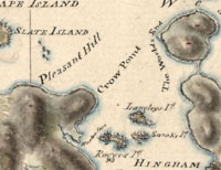
| Pleasant Hill |
| • |
Google Maps | Google Earth - Google |
| • |
"...follow the road around the north side of Crow Point, and then the beach along the foot of the fine hill next west of it, the bank of which is bordered by a heavy growth of Lindens, Canoe Birches (very rare hereabouts), and other trees. This is Pleasant Hill...", History of Hingham, Vol. 1, pg. 178, 1893 - Internet Archive |
|
| Powder House Hill |
| • |
Google Maps | Google Earth - Google |
| • |
"..Turning west into Elm Street, we soon pass over rising ground, the portion of which on the right, between Elm and Hersey streets, was called
Powder-House Hill. A red Powder House formerly stood upon it, in which was stored a supply of gunpowder. It was moved here from the hill just north of the New North Church, on Lincoln Street...", History of Hingham, Vol. 1, pg. 197, 1893 - Internet Archive |
|
| Ringbolt Rock |
| • |
Google Maps | Google Earth - Google |
| • |
"...Close here, too, is the great rock in the water which has been known from early times as The Ringbolt Rock, from the huge iron ring let into its surface for the accommodation of vessels hauling up the river...", History of the Town of Hingham, Massachusetts, Vol. 1, pg. 173, 1893, Town of Hingham - Internet Archive |
| • |
World's End Traik Map (PDF), World's End -Trustees of Reservations |
|
| Ripleys Hill |
| • |
Google Maps | Google Earth - Google |
| • |
Glad Tidings Historic District "...Encompasing both Glad Tidings Plain and Liberty Plain, it slopes up from Ripley's Hill (the rise in Main Steet after leaving Tower Brook) and stretched to Queen Anne's Corner at Main and Whiting Streets...", - Massachusetts Cultural Resource Information System (MACRIS) |
| • |
"...William [Ripley], 'and his wife, and 2 sons and two daughters came from Old Hingham and settled in New Hingham, 1638.' (Cushing's
MS.) The same year he had a grant of land at Hingham Centre containing four acres, a large proportion of which is still held in the
family namer....", History of Hingham, Vol. 4, pg. 131, 1893 - Internet Archive |
|
| Rocky Hill |
| • |
"...The road, after passing a row of sturdy red oaks on the left, which must have been old trees when the Pilgrims landed, reaches a descent cut through a rough ledge and known as Rocky Hill...", History of Hingham, Vol. 194, pg. 178, 1893 - Internet Archive |
|
| Rocky Neck |
|
| Roots Hill |
| • |
"...Where it crosses a small branch of Plymouth River is a peculiarly shaped field always known as Oxbow Meadow. The present part of Ward Street between its junction with Old Ward Street and Cushing Street, used to be called Fox Lane. Root's Bridge and Root's Hill are near the junction referred to...", History of Hingham, Vol. 1, pg. 183 , 1893 - Internet Archive |
|
| Squirrel Hill |
|
| Stony Hill |
|
| Stowells Hill |
| • |
"...Stowell's Hill is on Weymouth River, near the Alms House...", History of Hingham, Vol. 1, pg. 181, 1893 - Internet Archive |
| • |
"...one of the oldest houses in America, on Fort Hill Street, at the foot of the hill on which stood the old fort prior to King Philip 's War...Here Samuel Stowell lived. Later, on the same spot, over 250 years ago, the above house was built. It is still standing and has been occupied by at least five generations of Lue descendants of Samuel Stowell...", History of Hingham, Vol. 1, pg. 181, 1893 - Internet Archive |
| • |
"...Samuel [Stowell, Stoel], whose name is mentioned in Hobart's Diary as early as 1649, married in Hingham Oct. 25 of that year, Mary, daughter of John and Frances Farrow...", History of Hingham, Vol. 4, pg. 216, 1893 - Internet Archive |
|
| Tuckers Hill |
| • |
Google Maps | Google Earth - Google |
| • |
"...Between the southerly slopes of Crow Point and Pleasant Hill, and Walton's Cove on the south, is a slight eminence called Tucker's or Tucker's Hill. John Tucker was an early settler, coming in 1635...", History of Hingham, Vol. 1, pg. 178, 1893 - Internet Archive |
| • |
"...John [Tucker], had a house-lot of four acres granted him on Broad Cove (Lincoln) St., Sept. 18, 1635. He may have been a resident of Watertown for a short time, about 1636, as stated by Mr. Savage, but was in Hingham the year following, or soon after....", History of Hingham, Vol. 4, pg. 268, 1893 - Internet Archive |
|
| Turkey Hill |
| • |
USGS identified - MassMapper MassGIS |
| • |
Google Maps | Google Earth - Google |
| • |
"...Now let us return again to Leavitt Street, and, retracing our former course, turn to the eastward into Turkey Hill Lane, which leads up over three quite elevated eminences, until we reach the principal height of Turkey Hill. It is nearly a mile to this summit... Turkey Hill lies mostly in Hingham, but a part is in Cohasset. Its name was bestowed on account of the early abundance of wild turkeys there...", History of Hingham, Vol. 1, pg. 191 , 1893 - Internet Archive |
| • |
Turkey Hill - USGS Geographic Names Information System |
|
| Wards Hill |
| • |
"...Summer Street here was constructed from material taken from Ward's Hill, a high knoll of sand and gravel rising south from the beach, now known as Cobb's Bank, which in early times extended several hundred feet to the eastward. It is fast disappearing under the demand for sand and gravel for filling purposes...", History of Hingham, Vol. 1, pg. 174, 1893 - Internet Archive |
| • |
"...Samuel [Ward], had a grant of land on the Lower Plain 1636....", History of Hingham, Vol. 4, pg. 274, 1893 - Internet Archive |
|
| Worlds End |
|
| Zion Hill |
| • |
USGS identified - MassMapper MassGIS |
| • |
Google Maps | Google Earth - Google |
| • |
"..The Free Christian Mission, at some points also called Mt. Zion Chapel...", Holy Ghosts, 2015 - Hingham Historical Society |
| • |
"..relates to the section of Ward Street formerly known as Tuttleville, or Tuttle Village, and to the Zion's Hill section located on what is now High Street opposite French Street...", History and Survey of the Negro Community in Hingham, pg. 4, 1968 - Hingham Public Library |
| • |
"...At the corner of French and High streets is Nutty (or Nutter's) Hill, so called because the early settlers found walnuts there in great abundance...", History of Hingham, Vol. 1, pg. 182, 1893 - Internet Archive |
| • |
Historic Map of Hingham, Mass. - Hingham Public Library |
| • |
Zion Hill - USGS Geographic Names Information System |
|
|
|
 |
|
 |
|
 |
|
 |
|
 |
|
 |
|
| Bradley Hill |
 |
|
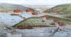
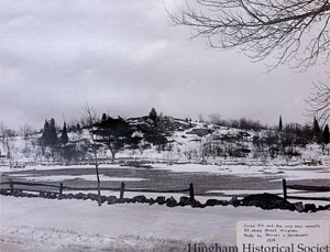
Crow Point
|
 |
|
 |
|
 |
|
 |
|
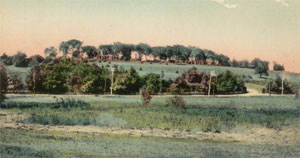
| Jones Hill |
 |
|
| Otis Hill |
 |
|
| |
| |
| |
| |
|
|
| More about Hingham's USGS-listed hills |
|
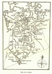
Hingham, Mass. was first settled in 1633, and was incorporated into a town in 1635, making it one of the first towns settled in Massachusetts, after Plymouth and Salem, and the original towns explored by the Puritans in 1630 along the Charles and Mystic rivers.1 Among those first settlers in 1633 were, “Nicholas Jacob with his wife and two children, and their cosen Thomas Lincoln, weaver, came from Old Hingham, and settled in this Hingham.”2 Old Hingham, is Hingham in England, and when more settlers arrived from there, it was decided to adopt that as a name. Thomas Lincoln the weaver was the first of many more Lincoln family members to emigrate to Hingham. Eventually there would be three more Thomas Lincolns. To distinguish the four, they are known by their occupations, weaver, miller, cooper, and husbandman (a farmer). It is Thomas Lincoln the weaver’s brother Stephen who is the first ancestor of Abraham Lincoln, the 16th president of the United States.3There is no Lincoln Hill in Hingham, but this a bronze statue of Lincoln in a small park (a replica of one that was created by Charles Keck for Wabash, Indiana),4 along with other historical sites, markers, and plaques for Lincoln family members. Hingham does have fifteen USGS-listed hills, only Quincy has more, and it has many of named hills in the Blue Hills Reservation within its borders. Hingham has no similar park. Why then are so many of Hingham’s hills listed by the USGS? Possibly because of Thomas T. Bouvé (1815-1896). |
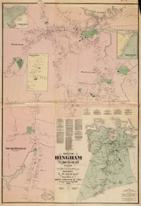
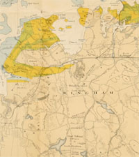
| The U.S. Board on Geographic Names was created in 1890 to standardize inconsistencies and contradictions among many names, spellings, and applications of geographic features in the country. In 1894, Henry Gannett, first director of the U.S. Geological Survey,5 and described as the "Father of the Quadrangle”,6 published the “Geographic Dictionary of Massachusetts, Bulletin 116.”7 It lists seven hills in Hingham, and it matches the hills shown on the 1888/1892 USGS Topographic maps. |
|
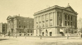
Chartered in 1830, the Boston Society of Natural History was a leading research intuition for men devoted to collecting and studying natural history specimens. Founded by a group of physicians, most members initially were amateur scientists, with professions such as doctors, lawyers, teachers and businessmen.8 After being a member since he was 19, Thomas Bouvé became president in 1870. He was the treasurer at an iron manufacturing company, with a great interest in geology, especially near his summer home in Hingham. In 1893, a committee from Hingham published a three-volume, 800-page history of their town. Almost of all first volume on the geology, mineralogy, animal life, botany, trees and shrubs, ancient landmarks, and military history, was written by Thomas Bouvé, and his two sons Edward and Walter. In it, the three authors identify and name just under 50 individual hills in Hingham. Fast forward to the 1936, and when an updated topographic map is published, the 15 hills it identifies are mentioned in the Bouvé’s work, with one exception. |
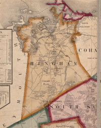
| For this survey, only the nine USGS-listed hills in northern Hingham, close to coast, are included: Baker Hill (148 ft.), Bradley Hill (82 ft.), Crow Point (0 ft.), Great Hill (105 ft.), Otis Hill (115 ft.), Planters Hill (118 ft.), Squirrel Hill (125 ft.), Turkey Hill (180 ft.), Worlds End (39 ft.) and Zion Hill (118 ft.). |
| Both Baker Hill and Otis Hill are named for early settlers in the town. Two Baker brothers, Nicholas and Nathaniel, came to Hingham in 1635 and received adjoining lots of five acres on the hill that carries their name. Nicholas would come to have extensive land holdings in Hull, and eventually move to Scituate where he was ordained as a minister. Less is known about his brother Nathaniel. John Otis likely came to Hingham as early as 1631 when it is recorded that he received a land grant. The Otis family originated in Glastonbury, England, not Hingham, and it is thought they moved to Hingham before leaving for America. The Weary-All-Hill name Otis gave to the hill in Hingham, refers to the hill in Glastonbury where the fable says Joseph of Arimathea stuck his staff in the ground and it bloomed into a thorn bush. |
| Turkey Hill is a common name for a hill with ten in Massachusetts. Great Hill also, there are Great Hills in Weymouth, Quincy, it’s a variant name for Allerton Hill in Hull, there’s a Great Hill in Chatham on the Cape, and north of Boston in Acton, Manchester, and Topsfield. Corey Hill in Brookline and Parker Hill (Mission Hill) in Boston were both known as Great Hill. In Massachusetts, the name is exclusively used in towns that were settled in 1600s. It’s possible the settlers gave the name Great Hill to what they thought was the tallest hill in town. While there are a number of Turkey Hills in Massachusetts, there is only one Squirrel Hill, and only three in the rest of the country. |
| How Zion Hill got its name is not clear. Early maps and writings give it the name Nutty Hill or Nutters Hill because "the early settlers found walnuts there in great abundance." But the first USGS Weymouth topographic map in 1936 identifies it as Zion Hill, and that’s what the USGS database lists without any variant name given. One possible reason relates to James K. Tuttle and the Free Christian Mission. In 1873, James K. Tuttle, a free African-American and shoemaker (it is thought that his father was brought the south by a ship captain and freed) led a group of residents to form a new church. The area of Hingham the town was built was called Tuttlesville for large number Tuttle descendants that lived there. At some point the name of the church was changed to the Mt. Zion Chapel. Zion Hill is located nearby.9 |
|
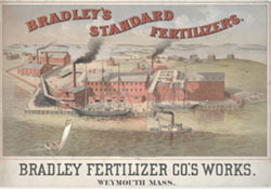
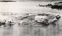
The “new” USGS-listed hill, not identified by the Bouvé’s is Bradley Hill. More of a spur of Squirrel Hill, Bradley Hill owes its name to William L. Bradley (1826-1894) an innovator in the field of chemical fertilizers and considered the founder of the fertilizer industry in the United States.10 In the early 1860s he purchased land in North Weymouth for a factory, and in Hingham for summer home. The Bradley Fertilizer Company was one of largest establishments of its kind in the world, and made the William very rich. He owned large tracts of land in nearly every Atlantic state from Maine to Florida.11 In 1881, with a business partner, he purchased James Madison’s Montpelier estate in Virginia.12 With an interest in trees and gardening, in later life, he established a nursery and did significant landscaping on Hingham estate. After his death, his daughter Abby made a large donation in his name to the Arnold Arboretum which they used to fund the creation of the Bradley Bibliography, a 100,000-plus list of woody plants.13 One of his sons, Peter B. Bradley (1850-1933), used the family land in Hingham on the opposite side of the Weymouth Back River to establish the “Hingham Stock Farm” and become one the first breeders of Arabian horses in America. On his land he had a race track and polo grounds.14 Much of the was requisitioned by Navy and turned into the Hingham Naval Shipyard during World War II. Bradley Hill is first identified on USGS Weymouth topographic map in 1936. |
|
|
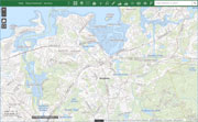
| Hingham Maps |
| • |
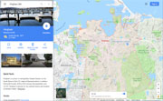
Hingham - Google Maps, Terrain |
| • |
Hingham - MassMapper MassGIS |
| • |
Hingham - USGS - The National Map |
| • |
Cohasset Quadrangle - 2018 (60 MB PDF) - USGS Topo Download |
| • |
Hull Quadrangle - 2018 (60 MB PDF) - USGS Topo Download |
| • |
Nantasket Quadrangle -: 2018 (60 MB PDF) - USGS Topo Download |
| • |
Weymouth Quadrangle - 2018 (60 MB PDF) - USGS Topo Download |
| • |
Hingham, Atlas of Plymouth County, Geo. W. Walker & Co., 1879 - State Library of Massachusetts |
| • |
Hingham maps, 17, 18, Atlas of Plymouth County, L.J. Richards & Co., 1903 - State Library of Massachusetts |
| • |
Historic Map of Hingham, Mass. - Hingham Public Library |
| • |
Hingham Heritage Google Map - Hingham Heritage Museum |
| • |
Maps - Hingham Historical Society |
| • |
Historic Districts Documents & Maps - Town of Hingham |
| • |
Wompatuck State Park Map - Friends of Wompatuck |
| • |
MapJunction |
|
|
| Hingham Sources |
| • |
History of the Town of Hingham, Massachusetts, Vol. 1, Part 1 & 2, 1893, Town of Hingham - Internet Archive |
| • |
History of the Town of Hingham, Massachusetts, Vol. 2, Vol. 3, 1893, Town of Hingham - Internet Archive |
| • |
History of the Town of Hingham, Plymouth County, Massachusetts, Solomon Lincoln, 1827 - Internet Archive |
| • |
Hingham, A Story of its Early Settlement and Life, its Ancient Landmarks, its Historic Sites and Buildings, Daughters of the American Revolution, 1911 - Internet Archive |
| • |
The Settlement of Hingham, Massachusetts, Louis C. Cornish, 1911 - Internet Archive |
| • |
The Hills of Hingham, Dallas L. Sharp, 1916 - HathiTrust |
| • |
Hingham: Through Time, Stephen Dempsey, Alexander Macmillan, 2014 - Google ebook preview |
| • |
Out of the Archives - Hingham Historical Society |
| • |
Local History & Genealogy - Hingham Historical Society |
| • |
Hingham, Massachusetts, Plymouth County - USGenWeb Genealogical Site |
| • |
Hingham, MHC Reconnaissance Survey Town Report (PDF), 1979 - Massachusetts Historical Commission |
| • |
Hingham, History of Plymouth County, Massachusetts, with Biographical Sketches of Many of its Pioneers and Prominent Men, Duane Hurd, 1884 - Internet Archive |
| • |
Geology of the Boston Basin, Pt. 2, Hingham, pg. 179, William O. Crosby, 1900 - Internet Archive |
| • |
World's End - Trustees of Reservations |
|
|
| Footnotes |
| 1 |
Massachusetts City and Town Incorporation and Settlement Dates - Commonwealth of Massachusetts |
| 2 |
Daniel Cushing' Record, The New England Historical and Genealogical Register, Vol. 15. pg. 25, 1861 - Interenet Archive |
| 3 |
Notes on the Lincoln Families of Massachusetts, pg. 5,, Solomon Lincoln, 1865 - Internet Archive |
| 4 |
Lincoln Monument of Wabash, Indiana - Wikipedia |
|
Abraham Lincoln Statues, Monuments, and Memorials - Postcardy.com |
|
Statues of Abraham Lincoln. Wabash, Indiana, pg. 89, Lincoln Financial Foundation Collection, 1931 - Internet Archive |
|
Abraham Lincoln Statue, Hingham, Massachusetts, David Pelland - CT Monuments.net |
| 5 |
Henry Gannett, Early American Geographer, 2012 - USGS |
| 6 |
Holmes, Walcott and Gannett, US geologists, 1897 - Science Photo Library |
| 7 |
A Geographic Dictionary of Massachusetts, Bulletin 116, Henry Gannett, 1894 - USGS |
| 8 |
The Rise and Fall of the Boston Society of Natural History, Northeastern Naturalist, Vol. 11, No. 1, pg. 81-108, Richard I. Johnson, 2004 - JSTOR |
| 9 |
History and Survey of the Negro Community in Hingham, 1968 - Hingham Public Library |
|
Holy Ghosts, 2015 - Hingham Historical Society |
|
Photo reveals Hingham’s forgotten black history, Jennifer Mann, 2009 - Wicked Local |
|
South Shore was haven for former slaves, Lane Lambert, 2011 - Patriot Ledger |
| 10 |
The Fertilizer Industry in Massachusetts, pg. 3, H.J. Wheeler, 1915 - Google ebook |
|
179 Commonwealth Ave. - Back Bay Houses |
|
An Historic Record and Pictorial Description of the Town of Meriden, Connecticut, pg 418, C. Bancroft Gillespie, 1906 - Internet Archive |
| 11 |
Garden and Forest, Volume 10, pg. 340, Charles S. Sargent,1897 - Google ebook |
| 12 |
History of Montpelier - The Digital Montpelier Project |
| 12 |
Alfred Rehder, the Bradley Bibliography and BHL, oh my!, 2013 - The Arnold Arboretum |
|
The Bradley Bibliography: A Guide to the Literature of the Woody Plants of the World, Alfred Rehde, 1911 - Google ebook |
| 13 |
The Forgotten Man: Peter Bradley’s Role in Early American Breeding, Charles and Jeanne Craver, Arabian Horse World, 1984 - Davenport Arabian Horse Conservancy |
|
Looking Back at South Shore History: From Plymouth Rock to Quincy Granite, John J. Galluzzo, 2013 - Google ebook preview |
|
|