| Hills of Medford, Mass. |
| | Hills | More about Medford's USGS-listed hills | Maps | Sources | |
| Acorn Hill |
| • |
Google Maps | Google Earth - Google |
| • |
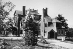
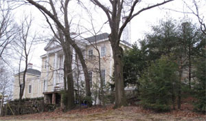
"...It was Peter and Shepherd’s ambitious plans for an undeveloped part of their estates at Point of Rocks and Acorn Hill that would ultimately bestow upon Medford the Brooks Estate in its present-day form....The younger Shepherd Brooks built his own summer home at Acorn Hill in 1880. Designed by noted 19th century architects Peabody & Stearns...", Brooks Estate Master Plan (PDF)/Internet Archive, 2011 - Medford-Brooks Estate Land Trust |
| • |
Brooks Estate - Medford, Mass., "...In 1660 Thomas Brooks, a puritan from Boston, purchased about 400 acres in Medford, establishing the Brooks Estate. The Brooks family went on to play an important role in the history of Medford, the Mass. Bay Colony and later in the Commonwealth of Massachusetts..." - The British Redcoat |
|
| College Hill |
|
| Ellen Hill |
| • |
"...View of the south west side of Ellen Hill, showing the birches which have come to occupy the old pasture land...", Job #1513, Fells (Middlesex) Reservation, A.A. Shurtleff, 1898 - Frederick L. Olmsted Archives NHS, NPS |
|
| Flagstaff Hill |
|
| Gerry Hill |
|
| Hasting Heights |
| • |
Google Maps | Google Earth - Google |
| • |
West Medford in 1870, "...The stone tower on Hastings Heights, as we call the hill now, overlooks the place.....", Medford Historical Society Papers, Vol. 8, 1904 - Persus Digital Library |
| • |
"...Mystic Mount, now known as Hastings Heights, situated between High and Woburn Streets....", Miller, pg. 3, 1917 - Google ebook |
| • |
Mystic Mount"...'Mystic Mount' is the former name for a hill (now known as 'Hastings Heights') sloping up from the banks of the Mystic River where it winds through the western portion of Medford, Massachusetts.....
...Around 1900, a tower was erected by the City Parks and Recreation Department at the pinnacle of Hastings Park, the former Mystic Mount,,," - Mystic Mount |
| • |
"..Edmund Trowbridge Hastings originated the improvements on the east side of the railroad. He owned property on both sides of High Street west of Woburn Street and resided near the river just east of a promontory near the river...
By 1855 only two dwellings existed at the northern end of Allston Street near Hastings Park, a rocky promontory between Laurel, Vernon, Allston and Mystic streets where a stone water tower constructed in this period remains...", West Medford, Medford Neighborhood Overviews (PDF) - Medford Historical Commission |
| • |
"..Edmund T. Hastings was a Boston merchant in the sale of West Indian goods and sperm oil in 1834-1836...", The Correspondence of Washington Allston, pg. 298,Nathalia Wright, 1993 - Google ebook preview |
|
| Little Pine Hill |
|
| Marm Simonds Hill |
| • |
Google Maps | Google Earth - Google |
| • |
The taverns of Medford, "...on the north side of the way from Medford to Woburn, and at the foot of ‘Marm Simonds' Hill’ (this hill was called in the early days of the plantation, Marabels Hill).....", Medford Historical Society Papers, Vol. 8, 1904 - Persus Digital Library |
| • |
High street about 1820, "...
Ma'am Simonds hill’ was named in honor of Mrs. Joshua Simonds who with her daughters ‘Nabby’ and Pamelia kept a dame school for many years in the house on the north side of High street.....", Medford Historical Society Papers, Vol. 8, 1904 - Persus Digital Library |
| • |
Marm Simonds Historic District Map - Medford Historic District Commission |
|
| Medford Lion |
| • |
"..At a respectful distance, from a carefully selected point of view, because of the trees alluded to, may best be seen
this boulder that requires but little imagination to be what some one has called it, the 'Medford Lion.' Just below Brooks street, coming toward Winthrop Square, is the place -- and look up....", Medford Historical Society Papers, Vol. 15, pg. 26, 1912 - Internet Archive |
|
| Mount Andrew |
| • |
USGS identified - MassMapper MassGIS |
| • |
Google Maps | Google Earth - Google |
| • |
"...As it will be necessary to have many new names to distinguish particular localities in so extensive a park, I would, with the utmost deference, suggest that the hill on which we stand should be called Mount Andrew, and the whole territory Mount Andrew Park, in honor of one of the best-beloved Governors of Massachusetts; and the beautiful sheet of water on the left, Lake Winthrop, in honor of its discoverer...." - Elizur Wright's Appeals for the Middlesex Fells and the Forests, pg. 32, Elizur Wright, The Medford Public Domain Club - Internet Archive |
| • |
John Albion Andrew, 25th Governor of Massachusetts 1861-1866 - Wikipedia |
| • |
Mount Andrew - USGS Geographic Names Information System |
|
| 90mm Site |
|
| Old Man of the Fells |
|
| Pasture Hill |
| • |
Google Maps | Google Earth - Google |
| • |
"...Pasture Hill, near the Square on the north side of the river, formerly abutted upon the river. It is quite a sightly place and has many fine dwelling houses located upon it.....", Hooper, pg. 12, 1906 - Internet Archive |
| • |
Why Mystic? "...From the ford onward, the sylvan scene must have been enchanting, as the Medford Pasture hill with its wooded slopes rose abruptly from the plain beside Gravelly brook, but more gently from the river....", Medford Historical Society Papers, Vol. 22 - Persus Digital Library |
| • |
"...Leaving the Square by Forest Street we soon get a good view, across the fields on the left, of Pasture Hill, the sightliest point of which, overlooking the lovely valley of the Mystic, is occupied by the picturesque club-house of the Medford Club....", Bacon, pg. 94, 1897 - HathiTrust |
|
| Pasture Hill - Fells Reservation |
|
| Pine Hill |
|
| Point of Rocks |
| • |
Google Maps | Google Earth - Google |
| • |
"...It was Peter and Shepherd’s ambitious plans for an undeveloped part of their estates at Point of Rocks and Acorn Hill that would ultimately bestow upon Medford the Brooks Estate in its present-day form....Point of Rocks was situated on the highest point of the Estate and had commanding views over the mostly open fields that surrounded it...", Brooks Estate Master Plan (PDF), 2011 - Medford-Brooks Estate Land Trust |
| • |
Brooks Estate - Medford, Mass., "...In 1660 Thomas Brooks, a puritan from Boston, purchased about 400 acres in Medford, establishing the Brooks Estate. The Brooks family went on to play an important role in the history of Medford, the Mass. Bay Colony and later in the Commonwealth of Massachusetts..." - The British Redcoat |
|
| Rams Head Hill |
|
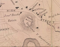
| Rock Hill |
| • |
Google Maps | Google Earth - Google |
| • |
"...Rock Hill or The Rocks, as it was formerly called, is just west of Marble or Meeting-house Brook and close to the river. It commands a good view of the river valley, both east and west.....", Hooper, pg. 12, 1906 - Internet Archive |
| • |
West Medford in 1870, "...the view of these was quickly broken by the seamed and scarred promontory of Rock Hill, where once was the home of Nanepashemit, and which commanded a view of the river in either direction.....", Medford Historical Society Papers, Vol. 8, 1904 - Persus Digital Library |
| • |
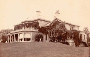
George P. Fernald House, "...The George Fernald House (1894) occupies the entire top of Rock Hill in Medford on a lot of 27,000 square feet which has a commanding view of the surrounding area...."- Massachusetts Historical Commission Information System (MACRIS) |
|
| Rock Hill - Fells Reservation |
|
| Silver Mine Hill |
|
| Sugar Loaf Hill |
| • |
Google Maps | Google Earth - Google |
| • |
Medford on the map, "...
Emperor street is part of the old lane or wood road leading from Winthrop street by the old railroad cut in Sugar-loaf hill. After crossing the west branch of meetinghouse brook it turns sharply to the left at the foot of a hill....", Medford Historical Society Papers, Vol. 22 - Persus Digital Library |
|
| Wenepoykin Hill |
|
|
|
 |
|
Middlesex Fells
Reservation |
 |
|
| Acorn Hill |
 |
|
| College Hill |
 |
|
 |
|
 |
|
| Hasting Heights |
 |
|
| Medford Lion |
 |
|
| Pasture Hill |
 |
|
| Point of Rocks |
 |
|
| Rock Hill |
 |
|
 |
|
| Sugar Loaf Hill |
 |
|
|
|
| More about Medford's USGS-listed hills |
|
How Medford was first settled is different from other towns in the Boston Basin. Typically, a group of settlers would obtain a land title from the General Court, then go and stake out tracts of that land for houses, farms, a common, meeting house, and a church. Medford, on the other hand, was owned by a single man.1 Matthew Cradock was a wealthy London merchant, politician, and a close friend of John Winthrop. Initially apprenticed to a business of trading animal skins and furs from Baltic countries, he invested in trading to the Mediterranean and Near East, became director of the East India Company, was owner or part owner of 18 ships, and was a major player in the tobacco trade to the West Indies and Virginia. In 1628, Cradock made a major investment in the New England Company, the precursor to the Massachusetts Bay Company, and was elected the first governor. With an unstable political environment, the company was concerned that the Royal Charter they had been given would be withdrawn. It was Cradock that suggested that because the charter did not specify where shareholders were to meet, they should transfer governance to the colony, away from interference from London. With that change, and not wanting to immigrate, Cradock gave the governor’s position to John Winthrop, and stayed in England, never visiting the colony.2 |
| Cradock would take his investment seriously sending employees and supplies to the colony almost immediately. In 1629, a year before John Winthrop arrived, Cradock’s men already had a farm on the banks of the Mystic river. Cradock would soon be granted the land for a plantation with him the sole owner. That plantation would eventually include almost all modern-day Medford. He sent people and supplies to build ships for what he hoped would be profitable trade in fish, skins, furs, timber, and any other unique New World commodities. The plantation did not prove to be a success. Other towns and ports would become centers of trade in those area. Cradock would die in 1641, and with his death, continuing investment in the plantation would cease. Eventually the land would be divided and sold off. The name Medford is thought to derive land Cradock owned in England that he called his “Manor of Metford.” Despite the plantation being a financial failure, Cradock’s support in the early formation of the colony was instrumental in it’s success. There is no hill named for Cradock, but there is a Cradock Bridge, the first being built across the Mystic river in 1637. It became a major route for traffic coming into Boston from the north.3 |
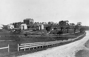
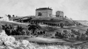
| College Hill (141 ft.), straddling the border between Medford and Somerville, is the location of Tufts University. Founded in 1852, Tufts College was named for Charles Tufts (1781-1876).4 He was an ancestor of Peter Tufts (1617-1700), a prominent early settler of Medford. The Peter Tufts house that still exists, is thought to have been built by his son, also Peter Tufts. Charles Tufts made his fortune in brick making business. Strong demand, and abundant quantities of clay deposits, led Medford to become a center of brick making. Charles Tufts, described his donation of land for the college as, "that bleak hill over in Medford." An earlier name for the hill, Walnut Tree Hill, alludes to its less-bleak earlier condition.5 John H. Hooper, in his 275th anniversary book for Medford, says “Walnut Tree Hill (College Hill) was at that time covered with a growth of walnut trees, and that they were cut down for the use of the army” during the Revolutionary war. In the 1852 Martin Draper map of Somerville, the hill is labeled “Walnut Hill.” It is unusual that the hill was never identified on any historic USGS topographic maps. Tufts College is labelled, as is the former reservoir on the hill. |
| For three of the USGS-listed hills Gerry Hill (249 ft.), Pine Hill (220 ft.), and Silver Mine Hill (210 ft.), the USGS National Map, historic USGS topographic maps, and historic maps, match. All three are in the Middlesex Fells Reservation. |
| Since the mid-1630s, there have been multiple immigrants named Gerry (also spelled Geary, Gary, Gare, etc.) arriving in New England.6 There are records showing a Thomas Geary requesting and receiving land in Charlestown End (today’s Stoneham) in 1675. Benjamin Geary was one of the residents petitioning to have Stoneham made a separate town. That happened in 1725. Another descendant, also named Thomas, married Abigail Vinton in 1724. She was the daughter of John Vinton, one of first board of selectman, along with Benjamin Geary, in the new town, and a major land owner in area. He is recorded as having paid the highest tax of any man in town. In the early 1800s, the family is spelling their name Gerry, and are still playing a prominent role in the town. Ira Gerry, born in 1806, was first president of the Stoneham Five Cent Savings Bank, a selectman, and large land owner. He and his brother Elbridge are described as ardent sportsman and hunters. This Elbridge Gerry is not the Elbridge Gerry of “gerrymanding” fame. Though likely related, that Elbridge Gerry was born in Marblehead in 1744. He was one of the signers of the Declaration of Independence, and fifth Vice-President of the United States, selected by James Madison. Unfortunately, he died a year and half into his term. |
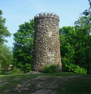
| While Pine Hill is an unremarkable name for a hill, the name of the stone tower on top of the hill honors a man who played a prominent role in the creation of Middlesex Fells Reservation, this at the end of a like filled with remarkable accomplishments. |
| Elizur Wright was born in 1804 in South Canaan, Conn. to a deeply religious family.7 When he was six years old his family packed their belongings into covered wagons and moved to Tallmadge in the Connecticut Western Reserve, near Akron, Ohio. Elizur’s father, also named Elizur, was a Yale graduate, fluent in Greek, Latin, and Hebrew, wrote mathematics papers on fluxions (the original term for derivatives in calculus), and was a Deacon in the church. The younger Elizur initially followed his father path, first to Yale, then into the ministry. The issue of slavery was beginning to pull the country apart, and foreshadowing a lifelong passion for fairness, Elizur had growing misgivings about the church’s support for re-colonizing slaves to Africa. Educated, articulate, a prolific writer, and passionate for a cause, he perfectly positioned to play an important role in the anti-slavery movement. Over the tumultuous years that followed he would be at the heart of the abolitionist movement, first in Washington, DC as secretary of the national anti-slavery society, editor and writer of several of its publications. |
| In 1838 Elizur moved to be Boston to be the editor of the Massachusetts Abolitionist. He would remain an outspoken spokesman against slavery, even getting arrested and charged for aiding an escaped slave, he was not convicted, but he also had to support a growing family. He and his wife Susan Clark (1810-1875) would have eighteen children born to them, six dying in infancy or as young adults, with twelve at most alive at any one time. |
|
The projects he undertook reflect a remarkably resourceful, intellectually curious man, passionately dedicated to both his family and social reform.8 Beyond his involvement in abolitionist movement, he is best known as the father of the life insurance industry, and the father of its regulation. Seemingly contradictory, he saw and wrote about issues of fairness for policy holders, and then used his mathematical skills to develop actuarial tables the insurance industry could use to be fair to customers, and profitable. He wrote about the issue in a newspaper he started and published, and then devised a mechanical device, an Arithmeter, to aid in insurance calculations. His daughter Lucy became the first woman acturary. Earlier, as a money-making opportunity, he translated and published the La Fontaine's Fables from French. He founded a newspaper, the Chronotype, which provided an outlet for his social ideas. He edited the Railroad Times magazine for a year, and then, at the request of a reader, helped him invent a spike-making machine. Always practical and mechanically adept, he made a centrifugal washing machine, developed an improvement to sewing machines, and patented two plumbing devices, improvements for a stop cock and pipe coupling. Always the reformer, Elizur spoke against the Comstock Law which sought to ban use of the mail to send “obscene” publications. He became president of the National Liberal League which advocated separation of church and state and the freedom of religion. He argued for woman’s suffrage, and attacked the “male” character of the bible. And he urged for a low and uniform postage rate. |
|
In 1864, at age sixty, Elizur bought four acres of land at the base of Pine Hill in Medford for a summer house.9 Over the next 20 years until his death, the creation of a park in what was then known as Five-mile Woods would be his last great cause as a reformer. The area had been used for logging and quarrying since colonial time, while abundant water powered early mills. Later in the mid-1800s, as the population of surrounding towns and cities grew, developers looked to divide up the land for homes and estates. Additional pressure for the land came from the same cities and towns looking to use the ponds as reservoirs for drinking water. Aligned up against this pressure were people like the naturalist Wilson Flagg, who would write about setting a Forest Preserve from development. But it would take the dedication, personal commitment, connections, and skill of Elizur Wright to mobilize support for creating the park, though not in his lifetime. The culmination of his efforts would be passage of the Massachusetts Forest Act of 1882. It gave towns and cities the authority to establish and acquire land for municipal forests. It wouldn’t be until 1892, when the efforts of landscape architect Charles Eliot, and journalist and civil engineer Sylvester Baxter, lead to the creation of the Metropolitan Park System, and the setting aside of the Middlesex Fells Reservation, a name Baxter suggested. |
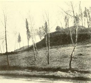
| Silver Mine Hill, as it name implies, is near the site of an 1881 mining operation. The ore did not prove valuable and the mine was abandoned. For the four remaining USGS-listed hills - Flagstaff Hill, Mount Andrew, Pasture Hill, and Rock Hill – none are based on geographical surveys. All four citations list only Alden T. Vaughan’s book, New England Frontier: Puritans and Indians 1620-1675. The hills are not mentioned in the book. For two of them, Pasture Hill and Rock Hill, historical maps and references place the hills in a different location, or they are different hills with the same names. The USGS coordinates for Mount Andrew, the name Elizur Wright thought would be appropriate for the Middlesex Fells park – John A. Andrew was the Massachusetts governor during the Civil War, and an abolitionist – puts it across the street from a supermarket parking lot. The Massachusetts GIS changes the location to a nearby ridge of hills. Other than Wright’s mention of the hill, no other historic references have been found. Flagstaff Hill is mentioned in the 1898 City of Medford Annual Report relating to a sewer line. No references are made to it in an Medford Historical Register. |
|
|
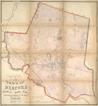
| Medford Maps |
| • |
Medford - Google Maps, Terrain |
| • |
Medford - MassMapper MassGIS |
| • |
Medford - USGS - The National Map |
| • |
Boston North Quadrangle - 2018 (60 MB PDF) - USGS Topo Download |
| • |
Lexington Quadrangle - 2018 (60 MB PDF) - USGS Topo Download |
| • |
Map of the town of Medford, Middlesex County, Mass., Henry F. Walling, 1855 - Norman B. Leventhal Map Center, Boston Public Library |
| • |
Map of Medford, Proceedings of the Celebration of the Two Hundred and Seventy-Fifth Anniversary of the Settlement of Medford, John H. Hooper, 1906 - Internet Archive |
| • |
Medford Maps: 33, 34, 35, 36, Atlas of Middlesex County, Volume 1, George W. Stadly & Co., 1900 - State Library of Massachusetts |
| • |
Map of Middlesex County, Mass., Henry F. Walling, 1856 - Library of Congress |
| • |
Medford Historical Maps Online - Medford Historical Society & Museum |
| • |
Medford Historical Maps - Medford Public Library |
| • |
MapJunction |
| • |
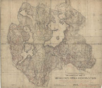
See: Hills of the Middlesex Fells Reservation |
|
|
| Medford Sources |
| • |
History of the town of Medford, Middlesex County, Massachusetts, Charles Brooks, 1855 - Internet Archive |
| • |
Proceedings of the Celebration of the Two Hundred and Seventy-Fifth Anniversary of the Settlement of Medford, John H. Hooper, 1906 - Internet Archive |
| • |
Medford Historical Register, 1898-1923 - HaithiTrust |
| • |
Medford Past and Present; 275th Anniversary of Medford, Massachusetts, 1905 - HaithiTrust |
| • |
A Brief History of Medford, George S. Miller, 1917 - Google ebook |
| • |
Medford, History of Middlesex County, Massachusetts, with Biographical Sketches of Many of its Pioneers and Prominent Men, Duane Hurd, 1890, Vol. 3 - Internet Archive |
| • |
Medford, History of Middlesex County, Massachusetts: Containing Carefully Prepared Histories of Every City and Town in the County, Samuel A. Drake, 1880, Vol. 2 - Internet Archive |
| • |
Echoes from Mystic Side: Malden, Melrose, Everett, Helen M. Hill , 1890 - HaithiTrust |
| • |
Medford, MHC Reconnaissance Survey Town Report (PDF), 1980 - Massachusetts Historical Commission |
| • |
Medford: Then & Now, Patricia Saunders, 2005 - Google ebook preview |
| • |
Medford, Walks and rides in the country round about Boston, pg. 82, Edwin M. Bacon, 1897 - Internet Archive |
| • |
Atlas of the boundaries of the city of Medford, Middlesex County, 1898 - State Library of Massachusetts |
| • |
Medford Open Space Plan, 2011 - City of Medford |
| • |
See: Hills of the Middlesex Fells Reservation |
|
|
| Footnotes |
| 1 |
A Peculiar Plantation: 17th Century Medford, Medford on the Mystic, Carl Seaburg, Alan Seaburg, 1980 - Medford Historical Society |
| 2 |
Matthew Cradock, Walter K. Watkins, Medford Historical Society, Vol. 9, 1906 - Google ebook |
| |
The ‘Cradock’ house, past and future, Ruth D. Coolidge, Medford Historical Society, 1926 - Persus Digital Library, Tufts University |
| |
Governor Cradock's Plantation, Walter H. Cushing, The Medford Historical Register, Vol. 1, pg. 138, 1898 - Google ebook |
| 3 |
Chronicles of the First Planters of the Colony of Massachusetts Bay from 1623 to 1636, Alexander Young, 1846 - Google ebook |
|
The Cradock Family, Francis Brinley, The New England Historical and Genealogical Register, Vol. 3, pg. 25, 1854 - Google ebook |
|
Merchants and Revolution: Commercial Change, Political Conflict, and London's Overseas Traders, 1550-1653, Robert Brenner, 2003 - Google ebook preview |
|
The Massachusetts Bay Company and Its Predecessors, Francis Rose-Troup, 1930 - Google ebook preview |
| 4 |
The Founding of Tufts University - Tufts |
|
Charles Tufts: Farmer, Manufacturer, College Founder (PDF) - Charlestown Historical Society |
|
Making Bricks in Medford - Medford Historicl Society |
|
Peter Tufts House - MACRIS, Massachusetts Historical Commission |
| 5 |
The Walnut Tree Hill division of the stinted pasture, John H. Hooper, Medford Historical Society, 1912 - Persus Digital Library |
|
Hooper, pg. 38, 1906 - Internet Archive |
| 6 |
History of Stoneham, Massachusetts, William B. Stevens, 1891 - Internet Archive |
|
Hurd, pg. 498, 1890 - Internet Archive |
|
Geary Register Report, PDF - Kristin C. Hall |
|
Notes on the Gary Family, The New England Historical & Genealogical Register, Vol. 11, pg. 346, 1857 - Google ebook |
|
Family of Hannah Green (15870) & John Vinton - Pane-Joyce Genealogy |
|
The Vinton Memorial, John A. Vinton, 1858 - Google ebook |
|
Vital Records of Stoneham, Massachusetts, to the End of the Year 1849, pg. 26, 1918 - Google ebook |
| 7 |
Elizur Wright, The Father of Life Insurance, Philip G. Wright, Elizabeth Q. Wright, 1937 - HathiTrust |
|
Elizur Wright, Cambridge Sketches, pg. 286, Frank P. Stearns, 1905 - Internet Archive |
|
Elizur Wrigh Papers (PDF), 2010 - Library of Congress |
|
Elizur Wright - Social Networks and Archival Context |
|
Bearing Witness Against Sin, Michael P. Youg, 2006 - Google ebook preview |
|
Elizur Wright: Abolitionist, Roderick Bradford, 2015 - Vimeo |
|
The Heretical Abolitionists, Roderick Bradford, 2105 - Vimeo |
| 8 |
Acturary Hall of Fame - Elizur Wright (PDF) - NYU-Stern |
|
Elizur Wright Commoration (PDF), 1985 - Society of Acturaries |
|
Fables of Fontaine, Translated by Elizur Wright, 1856 - Internet Archive |
| 9 |
Elizur Wright's appeals for the Middlesex Fells, Ellen Wright, 1893 - HathiTrust |
| |
Elizur Wright and the Middlesex Fells, Medford Historical Society Papers, Vol. 4, Ellen M. Wright, 1901 - Persus Digital Library, Tufts University |
| |
A Forest Preserve - A Proposal to State and City Governments, pg. 11, The Magazine of Horticulture, Wilson Flagg, 1856 - Google ebook |
|
History of the Fells, Mike Ryan, 2014 - Friends of the Middlesex Reservation |
|
Charles Eliot - The Cultural Landscape Foundation |
|
Sylvester Baxter - The Cultural Landscape Foundation |
|
Elizur Wright Dead, Obituary, Nov. 23, 1885 - Boston Globe |
|
|