| Hills of Saugus, Mass. |
| | Hills | More about Saugus' USGS-listed hills | Maps | Sources | |
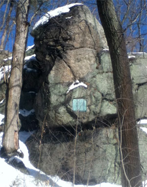
| Appletons Pulpit |
| • |
Google Maps | Google Earth - Google |
| • |
"...in September, 1687, we are informed, upon the tablet on the well-known rock in Appleton Street, at the Centre, that ''resisting the tyranny of Sir Edmond Andros, Major Samuel Appleton, of Ipswich, spoke to the people in behalf of those principles which later were embodied in the Declaration of Independence...", Atherton, pg. 26, 1916 - Internet Archive |
| • |
Appleton's Pulpit, "...Appleton hid in the home of his son, Colonel Samuel Appleton, who owned the Saugus Iron Works property (in what was then part of Lynn, Massachusetts). While there, Appleton, according to tradition, delivered an address from a rocky cliff near the Iron Works in which he denounced the tyranny of Andros. The place where he is said to have delivered the speech became known as Appleton's Pulpit..." - Wikipedia |
| • |
Memorial of Samuel Appleton of Ipswich, Massachusetts with genealogical notices of some of his descendants, Isaac A. Jewett, 1850 - HathiTrust |
|
| Ash Hill |
|
| Baker Hill |
| • |
USGS identified - MassMapper MassGIS |
| • |
Google Maps | Google Earth - Google |
| • |
"...The hill to which his name was first given, has known no other, and yet stands, 'rock-ribbed and ancient,' an enduring monument to the God-fearing, liberty-loving and hard-working pioneer who gave us this goodly heritage......", A Genealogy of the Descendants of Edward Baker of Lynn, Mass, 1630, pg. 7, 1867 - Internet Archive |
| • |
"...Edward Baker, who was awarded 40 acres in 1638, were also prominent. Baker's Hill, Cliftondale, bears Baker's name......", Atherton, pg. 18, 1916 - Internet Archive |
| • |
"...Edward [Baker] was an Englishman, a farmer and a Protestant, and by 1638 a Congregationalist, arriving in Boston/Salem and settling on the south side of Baker's Hill in Saugus (then Lynn) MA....", My 7th Great Grandfather, Edward Baker of Lynn (Saugus), Massachussetts - Family Stories from Long Ago |
| • |
Baker Hill - USGS Geographic Names Information System |
|
| Ballards Hill |
| • |
Google Maps | Google Earth - Google |
| • |
Map of Lynn and Saugus, Alonzo Lewis, 1829- Norman B. Leventhal Map Center, Boston Public Library |
| • |
"...William Ballard was one of the very earliest. He received 60 acres of land by allotment in 1638. This farm constituted the village of East Saugus...", Atherton, pg. 18, 1916 - Internet Archive |
|
| Breakheart Hill |
|
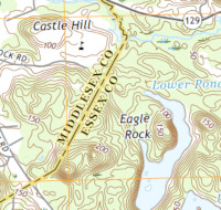
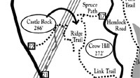
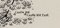
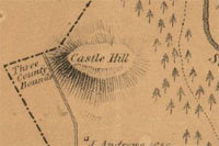
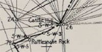
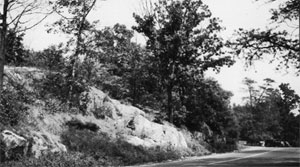
| Castle Hill |
| • |
USGS identified - MassMapper MassGIS - |
| |
|
| • |
Google Maps location, 3D view (PC) - Google Maps |
| • |
"...Castle Hill is situated on a rocky hill known as Castle Rock, in the northwestern part of the town of Saugus and about two miles southeast of the village of Wakefield..." - Boundaries Atlas, Saugus, pg. 6, 1902 - State Library of Massachusetts |
| • |
"...
...", A Dictionary of Altitudes in the United States, pg. 424 , Henry Gannett, USGS, Department of the Interior, 1906 - HathiTrust |
| • |
Breakheart Reservation Trail Map (PDF), Breakheart Reservation - North Shore Nature |
| • |
Castle Hill - USGS Geographic Names Information System |
|
| Catamount Hill |
| • |
"..Newhall also informs us that ''tradition says that in these troublous times (1687) a watch was stationed
on the hill (near Appleton's pulpit) to give alarm of any approach of the Crown officers to arrest their man.
The watch was to signal their approach by crying, 'Caleb, mount!' and from this cry came the name of the hill." It is known even to this day as Catamount Hill and pasture......", Atherton, pg. 26, 1916 - Internet Archive |
|
| Choose Hill |
| • |
Google Maps | Google Earth - Google |
| • |
"...a committee was appointed to 'chuse' a place. They selected a hill, now included in the bounds of Saugus, which was thence called Harmony Hill....", Lews, Newhall, pg. 310, 1890 - Internet Archive |
| • |
"...One of the resulting events from the building of this house upon the Common, instead of the compromise location 'Choose Hill' proposed by the settlers at Saugus and Lynnfield...", The Register of the Lynn Historical Society, Vol. 1, pg. 9 , 1900 - Internet Archive |
| • |
History of Wakefield (Middlesex County) Massachusetts, pg. 24 , William E. Eaton, 1944 - Internet Archive |
|
| Close Hill |
|
| Crow Hill |
|
| Eagle Rock |
|
| Fuller Hill |
| • |
Google Maps | Google Earth - Google |
| • |
Lynn Woods Reservation Trail Map (PDF) - Friends of the Lynn Woods |
| • |
"...Another of our hills, that bold sienite knob on the border line between Saugus and Lynn, has been marked on maps as "Mount Tabor." It is not a mountain. It is a shapely, sightly hill that was known in early deeds and days, as Fuller Hill.... The map of the Woods now shows the location of Fuller Hill. It perpetuates the name of the founder, John and also that of Edward, his active successor in the time of the great land division...", The Register of the Lynn Historical Society, Vol. 18, pg. 92 , 1915 - Internet Archive |
| • |
"...John Fuller came from England, with his brother Samuel, in 1630, and when they arrived in Boston...After residing there several years, Samuel went to Scituate, and John, in 1644, came to Lynn...", Newhall, pg. 186 , 1890 - Internet Archive |
|
| Golden Hills |
|
| Hatchs Hill |
|
| Hawkes Hill |
| • |
"...Hawkes' Hill has been put in excellent condition the past season, with new railings on the sides, and a few trees removed ; if a few more could be cut down it would benefit the hill by letting in the sun to dry the mud and frost, for while we enjoy the shade, we much more admire the bright sunshine...", Annual Reports of the Town of Saugus, pg. 30, 1891 - Internet Archive |
|
| Kents Hill |
| • |
"...The road from Kent's Hill, Cliftondale, to Trefethen's is in the worst condition of any main heavy travelled road in Town, and should be graded by all means...", Annual Reports of the Town of Saugus, pg. 25, 1894 - Internet Archive |
|
| Mount Moriah |
|
| Pleasant Hill |
| • |
"...The post-offices are Saugus (centre), East Saugus and Cliftondale; and these, with Pleasant Hill, are stations on the Saugus Branch of the Boston and Maine Railroad...", Nason, pg. 583, 1890 - Internet Archive |
|
| Robinsons Hill |
|
| Rocky Hill |
|
| Round Hill |
| • |
Google Maps | Google Earth - Google |
| • |
"...Round Hill is conical in shape, rising very steep and abrupt, 125 or 150 feet high and 600 feet long. On its apex is a small area of table land, where there is a view of the meandering Saugus River at its feet and the Atlantic Ocean in the distance. Round Hill has associations with the Native American occupation of the Saugus area...", Plans for a Park at Round Hill in Saugus - Saugus.com (Internet Archive) |
| • |
"...Art. 29. To see if the Town will make an appropriation of five thousand dollars ($5,000) for the purchase of the land known as Round Hill, consisting of nearly five acres, for the purpose of a Playground, and for the preserving of the site from which the Town Seal was taken, and which will give the Town gravel enough to pay for it, or to see what action the Town will take in the matter...", Annual Reports of the Town of Saugus, pg. 30, 1910 - Internet Archive |
| • |
History of the Round Hill Historic Site (video), Marilyn Carlson, Saugus Historical Society, 2017 - Internet Archive |
| • |
Montowampate: "...An image of Montowampate was included on Saugus' town seal. He is depicted holding a bow and arrow in front of Round Hill and the rising sun...", - Wikipedia |
|
| Snows Hill |
|
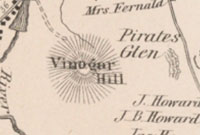
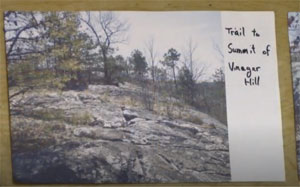
| Vinegar Hill |
| • |
USGS identified - MassMapper MassGIS |
| • |
Google Maps | Google Earth - Google |
| • |
Hawkes to discuss history of Vinegar Hill in Saugus, "..Vinegar Hill is one of the historic natural areas in Saugus, an elevated area in the neighborhood of Lynnhurst adjacent to Pirate’s Glen. It may have gotten its name for an old apple orchard and cider mill near the site. The trail on the crest of the hill provides views out across the center of town toward Melrose, and affords some of the most beautiful sunset scenes in town...", Saugus Historical Society, 2017 - Wicked Local Saugus |
| • |
"..Vinegar Hill in Saugus is believed to be so named because an early property owner who operated an apple orchard and cider mill there also produced vinegar...", It’s all in the names Emily Sweeney, June 16, 2013 - Boston Globe |
| • |
The History of Vinegar Hill (video), Tim Hawkes, Saugus Historical Society, 2017 - Vimeo |
| • |
Vinegar Hill - USGS Geographic Names Information System |
|
|
|
 |
|
 |
|
 |
|
| Appletons Pulpit |
 |
|
| Castle Hill |
 |
|
 |
|
 |
|
 |
|
 |
|
| Close Hill |
 |
|
| Round Hill |
 |
|
| Vinegar Hill |
 |
|
 |
|
| |
|
|
| More about Saugus' USGS-listed hills |
|
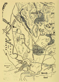
In 1637 the territory then known as Saugus (which contained the present-day cities and towns of Saugus, Swampscott, Nahant, Lynn, Lynnfield, Reading, and Wakefield) was renamed Lynn. In 1815 present-day Saugus split off and was incorporated as a town. The name Saugus is derived from a Native American word meaning either “extended” or “small outlet.” The town has five USGS-listed hills, two of which are in the Breakheart Reservation.1 Called “Six Hundred Acres” in colonial times, the land was divided among the first settlers and was primarily used as a place to cut firewood. The name “breakheart” is thought to date to the Civil War era and referred to the hardship and isolation of men training there. The two USGS-listed hills in the park are Castle Hill (276 ft.) and Eagle Rock (167 ft.). The naming of both hills could date from the Civil War era, or possibly when the land was purchased in the late 1800s and used as a private hunting and camping retreat. (See note below about location of Castle Hill label in US Topo National Map). The summit Mount Moriah (151 ft.) is located in the Lynn Woods Reservation, and like several other “Mounts” in the park, has a name that was taken from a mountain mentioned in the Bible. |
| USGS-listed Baker Hill (180 ft.) was named for one of the first settlers in the area, Edward Baker (c.1610-1687).3 There is no record of when he immigrated to New England, or even when he was born. He first appears in Lynn town records when he takes the Freeman’s oath in 1638. In that same year he is awarded 40 acres of land on the south side of the hill in Saugus, marries Joan (or Jane, her last name is not known), and becomes a father when their first is child born. The couple, it is thought, go on to have seven more children, all of whom it appears survive childhood, something quite rare for the time. The story of the first-generation yeoman farmer overcoming challenges in a new land is common for early settlers in New England, but in 1657 Baker does something very out of the ordinary. He packs up the family, with kids ages 16 to a toddler, and moves nearly 100 miles west to the recently established town of Northampton in the wilderness 15 miles north of Springfield on the Connecticut river. |
| It is not recorded why Baker made such a risky move, or even how he would have known the town existed. At that time, religious controversies sometimes led to congregations splitting up with one group moving away, usually en masse. That doesn’t appear to have been the case for Baker. He is described as a pious man and there are no records of difficulties with church authorities in Lynn. There was no church in Saugus until 1738, when the family had already left. Baker had received a relatively small grant of 40 acres of land and, located on the rocky northern rim of the Boston Basin, it was not prime farm land. For Baker, with a growing family to feed, he had to find a different place to live. There is no record of how he heard about the existence of Northampton where good land was available to settlers. But there is record of Baker having business dealing with the nearby Saugus Iron Works. Finding enough skilled and unskilled workers was an issue at the operation, and one solution was using Scottish prisoners that had been captured at a battle at Dunbar, Scotland. Approximately 150 prisoners were sent to New England in 1650, of those that survived the voyage, some worked at the iron works, some were sent to Maine to work at the saw mills, and some were purchased by others including William Pynchon (1590-1662), the founder of Roxbury and Springfield, Mass. |
| William Pynchon4 is one of an interesting list of prominent men, and women, who would leave Boston and start new communities around New England after they had come into conflict with the rigid religious doctrine of John Winthrop and the early Puritan leaders. Pynchon astutely had realized that the Connecticut river and its valley offered both easy access to the interior, and abundant rich alluvial soil for farming. He needed people, and Scots prisoners would do. Its possible Baker heard about the opportunities on the Connecticut river valley from people at the iron works. |
| Baker and then his children in Northampton would receive grants of lands and purchase more. He and his descendants would become respected and prominent members of the town. But there was a risk living in the wilderness. Pynchon, unlike many in New England, believed in working the Native American peoples. With his guidance Springfield became an important trading post, and Pynchon, a dominant player in the fur trade. He returned to England in 1652, though not before writing a religious book that infuriated officials earning it the dubious honor of being the first book banned and burned in New England. His son John Pynchon would take over and continue the expansion of settlements up the Connecticut river. But relations with Native Americans would worsen eventually leading to the King’s Philips War, during which Edward Baker’s eldest son Joseph, and his son Joseph, would be killed by Native Americans in 1675. |
| After living in Northampton for over twenty-five years, Baker and his wife returned to Lynn. No reason is known, though they still had family in the area. Their daughter Mary (1642-1719) had married George Sumner (1634-1715). Their great-grandson Increase Sumner (1746-1799) was the fifth governor of Massachusetts. His son, William H. Sumner (1780-1861), was instrumental in the development of Noddle Island, today’s East Boston, and who the Sumner tunnel is named for. |
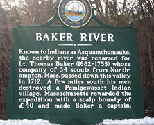
| Back in Northampton, relations with local Native Americans continued to deteriorate. The King Philip's War had cost the Baker’s a son and grandson. Their son Timothy Baker (1647-1729) was a member of the militia and fought during the war. His son, Thomas Baker (1682-1753), would be an active participant in the fighting between the English, Native Americans, and then the French. The story of his life could be a movie. Different versions of the story exist, with the telling reflecting the author’s viewpoint on the morality of what he did.5 But even just the documented facts are compelling. His father, for his efforts in the earlier fighting, had received a grant of land in Deerfield, the next town being settled north on the Connecticut river. Thomas was there in 1704 when a group of French and Native Americans raided the town. Just under 50 villagers were killed, and over 100 taken captive, including Thomas. The incident is known as the Deerfield Massacre. What followed for the captives was a 300-mile forced march to Canada in harsh winter conditions where many perished. |
| |
 |
| |
|
During his imprisonment in Canada Thomas meets Christine LaBeau (1689-1773). Her real name was Margaret Otis. She had been kidnapped with her mother in 1689 and brought to Canada. Only three months old at the time, she was raised as a French Roman Catholic. At age 16, just before she met Thomas, she married a Frenchman. There was an escape, or possibly a ransom paid, and for Thomas, a long march south without provisions until he finally reached Deerfield. In the following years Thomas would become, “a good Indian fighter, somewhat rough in manners and outspoken.” What that meant was that he was proficient at killing Native Americans. The Baker river in New Hampshire is named for him recalling a raid he lead in 1712 that destroyed a Pemigewasset Indian vilage killing women and children. Retreating after the raid, the group was pursued by the returning Native American warriors. In the fire fight that ensued, Thomas killed and scalped the chief Watarnomee. For his efforts he was given a reward and promotion. |
| A story with much cruelty takes a turn in 1714 when Thomas is back Montreal with a group sent by the Puritan government to ransom back captives. He meets Christine (nee Margaret) again. Now a 25-year old widow with two living children. They fall in love and make plans to leave Canada. Authorities initially refused to let her go, and finally only agreed if she leaves her young children behind. Her mother, by then adapted and accustomed to French life, tried to talk her out of going. But she left anyway, leaving her children behind. Unfortunately, she would never see them again. Both died before becoming adults. Thomas and Christine would marry, and eventually settle in Dover, N.H. The town where she had lived before being kidnapped. Christine would out live Thomas by 20 years. Dying just before the Revolutionary war, she would become famous as an icon of an earlier era. |
| USGS-listed Vinegar Hill (187 ft.), near the Saugus Iron Works, is reported to have received its name because an early property owner had an apple orchard there, and a nearby cider mill produced vinegar. Just south of Vinegar Hill, on the Saugus river, is Pirate’s Glen. It and Dungeon Rock in Lynn are places in a legend involving a sinister ship, buried treasure, and great earthquake.2 |
|
|
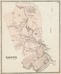
| Saugus Maps |
| • |
Saugus - Google Maps, Terrain |
| • |
Saugus - MassMapper OLIVER |
| • |
Saugus - USGS - The National Map |
| • |
Lynn 1944 Quadrangle - USGS Historical Topographic Map Explorer |
| • |
Boston North 1943 Quadrangle - USGS Historical Topographic Map Explorer |
| • |
Lynn Quadrangle - 2018, 2015 (PDF) - USGS Topo Download |
| • |
Boston North Quadrangle - 2018, 2015 (PDF) - USGS Topo Download |
| • |
Saugus, D.G. DeBeers & Co. 1872 - Salem State University Library |
| • |
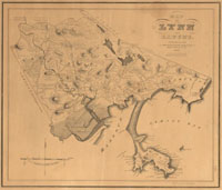
Map of Lynn and Saugus, Alonzo Lewis, 1829- Norman B. Leventhal Map Center, Boston Public Library |
| • |
Atlas of Lynn, Swampscott and Saugus, 23, 24, published by L.J. Richards & Co., 1897 - State Library of Massachusetts |
| • |
Atlas of the boundaries of the city of Lynn and towns of Nahant, Saugus, and Swampscott, Essex County and Wakefield, Middlesex County, 1902 - State Library of Massachusetts |
| • |
Breakheart Reservation Trail Map (PDF), Breakheart Reservation - North Shore Nature |
| • |
MapJunction |
|
|
| Saugus Sources |
| • |
History of Saugus Massachusetts, Horace H. Atherton, 1916 - Internet Archive |
| • |
History of Lynn, Essex County, Massachusetts, including Lynnfield, Saugus, Swampscott, and Nahant, Alonzo Lewis, James R. Newhall, 1865 - Internet Archive |
| • |
History of Lynn, Essex County, Massachusetts, including Lynnfield, Saugus, Swampscott, and Nahant, 1629-1864, Alonzo Lewis, James R. Newhall, 1890 - Internet Archive |
| • |
History of Lynn, Essex County, Massachusetts, including Lynnfield, Saugus, Swampscott, and Nahant, 1864-1890, James R. Newhall, 1890 - Internet Archive |
| • |
History of Lynn, Essex County, Massachusetts, including Lynnfield, Saugus, Swampscott, and Nahant, 1883, James R. Newhall, 1883 - Internet Archive |
| • |
Hearths and Homes of Old Lynn, with Studies in Local History, Natham M. Hawkes, 1907 - Internet Archive |
| • |
Saugus, History of Essex County, Massachusetts, with Biographical Sketches of Many of its Pioneers and Prominent Men, Duane H. Hurd, 1888 - Internet Archive |
| • |
Saugus, A Gazetteer of the State of Massachusetts with Numerous Illustrations, Elias Nason, 1890 - Internet Archive |
| • |
Saugus, Massachusetts, Elsie E. Hatch, New England Magazine, pg. 480, Vol. 35, 1907 - Internet Archive |
| • |
Breakheart Reservation - Massachusetts Historical Commission Information System (MACRIS) |
| • |
Breakheart Reservation Parkways - Massachusetts Historical Commission Information System (MACRIS) |
| • |
Breakheart Reservation: Images of America, Alison C. Simcox, Douglas L. Heath, 2013 - Google ebook preview |
| • |
The Register of the Lynn Historical Society - Internet Archive |
| • |
Saugus, MHC Reconnaissance Survey Town Report (PDF), 1985 - Massachusetts Historical Commission |
| • |
Geology of the Igneous Rocks of Essex County, Massachusetts, Charles H. Clapp, USGS, Dept. of the Interior, 1921 - Google ebook |
|
|
| Footnotes |
| 1 |
Breakheart Reservation - North Shore Nature |
|
Breakheart Reservation - Essex National Heritage Area |
|
Breakheart Reservation, 2016 - New England Nomad |
| 2 |
History of Vinegar Hill, Tim Hawkes, Saugus Historical Society, 2017- Internet Archibe |
|
Pirates;' Glen and Dungeon Rock, Nathan Ames, 1853- Hathitrust |
| 3 |
A genealogy of the descendants of Edward Baker of Lynn, Mass, 1630, Nelson M. Baker. 1867 - HathiTrust |
|
History of Northampton, Massachusetts, James R. Trumbull, 1898 - HathiTrust |
|
My Baker Ancestors Part 1, 2010 - Baker Family Tree |
| 4 |
William Pynchon Buys Land for Springfield - Mass Moments |
|
The Price of Suffering: William Pynchon and The Meritorious Price of Our Redemption - The Public Domain Review |
|
Winthrop Buys Passage for Ironworkers - Mass Moments |
| 5 |
Captain Thomas Baker, Thompson Lineage, with Mention of Allied Families, William B. Thompson, 1911 - Internet Archive |
|
Christine Otis, The Otis Genealogy, Vol. 5, pg. 189, New England Historic, Genealogical Society, 1851 - Google ebook |
|
The Deerfield Massacre, John Demos, 1993 - American Heritage |
|
Raid on Deerfield: The Many Stories of 1704, 2004 - Pocumtuck Valley Memorial Association |
|
Christine Otis Baker, Captured by Indians, John Scales - Dover Public Library |
|
Lieutenant Baker's Expedition, The History of Warren, pg. 81, William Little, 1870 - Google ebook |
|
Badass Women of History--Christine Otis Baker, Stephanie McKenzie, 2016 - Steemit |
|
|