| Hills of Quincy, Mass. |
| | Hills | More about Quincy's USGS-listed hills | Maps | Sources | |
| Babel Rock |
|
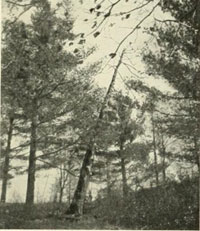
| Billings Rocks |
| • |
Google Maps | Google Earth - Google |
| • |
"... Along the shore at the left, after passing the factory of Bosson & Lane, is an elevation which has been known since early Colonial times as 'Billing's Rocks', on which tradition tells us was the home of Sir Christopher Gardner, a notorious character of the early days...", Quincy Historical Society Route Map, pg. 13, 1921 - Internet Archive |
| • |
"... In the year 1633 Sir Christopher Gardner lived on the banks of the Nemasket, after his departure from England in disgrace...In England he had been a gentleman of influence, a knight of the Holy Sepulchre at Jerusalem, and a connection of the Bishop of Winchester, but a zealous papist in disguise...", History of the Town of Middleboro, Massachusetts, Vol. 1, pg. 26, Thomas Weston. 1 - HathiTrust |
| • |
"... He applied to several churches for admission to membership; but as he was attended by a handsome young woman, whom he passed off as his cousin but to whom he was suspected of sustaining a criminal relation, his application was refused. It was reported that he had two wives in England. When this accusation reached the government of
Massachusetts they determined to arrest him. Being informed of their design, Gardner fled from their jurisdiction and concealed himself among the Namasket Indians within the limits of the Plymouth colony...", Sir Christopher Gardner, pg. 167, Plymouth and the Pilgrims, Joseph Banvard, 1851 - Google ebook |
|
| Boyce Hill |
|
| Buck Hill |
|
| Burnt Hill |
|
| Chapel Rocks |
|
| Chickatawbut Hill |
|
| Cranch Hill |
| • |
Google Maps | Google Earth - Google |
| • |
President's Hill - Hospital Hill - Cranch Hill "...the Cranch Hill trust was located west of both Presidents Hill and Presidents Hill
Annex. Originally, this land had been acquired by John Adams in the 1790s from the Honorable Richard Cranch, his brother-in-law and well-known state legislator from Quincy..." - Massachusetts Cultural Resource Information System (MACRIS) |
| • |
Richard Cranch (1726-1811) "...In 1792 [Richard Cranch] was asked to furnish a name for the new town and he proposed Quincy in honor of Col. John Quincy which was accepted.... He married Nov. 25, 1762 Mary Smith, sister of Abigail wife of President John Adams..." - Geni.com |
| • |
Quincy says goodbye to hospital ‘up the hill’, "...As with almost everything in Quincy, there’s history here. Before it was Hospital Hill, it was Cranch Hill: Richard Cranch, who married Abigail Adams’ sister, owned a farm on the site. Before that, it was President’s Hill: John Adams owned the land...", Nov. 29, 2014 - Boston Globe |
|
| Forbes Hill |
| • |
USGS identified - MassMapper MassGIS |
| • |
Google Maps | Google Earth - Google |
| • |
Forbes Hill Field, " (Internet Archive)...Once the site of the City’s water reservoir, a large granite tower, built in 1901-1904, is the only reminder of the park’s interesting history. Forbes Hill was likely named for the influential Forbes family that inhabited the area until W. Cameron Forbes had his land taken by the State by eminent domain to build the reservoir..." - Discover Quincy |
| • |
Forbes Hill Standpipe "...The Forbes Hill Reservoir and standpipe were built by the Metropolitan Water Board to supply the City of Quincy water after it joined the Water System in 1897...", - Massachusetts Cultural Resource Information System (MACRIS) |
| • |
"...Third Hill may be approached by Summit Avenue. In 1903, the Metropolitan Water
Commission selected this site for the location of a reservoir and water tower. This
hill being the highest elevation in this vicinity, one obtains a magnificent view of the surrounding country and waterfront of our City. ...", Quincy Historical Society Route Map, pg. 28, 1921 - Internet Archive |
| |
"...On the south a straight line drawn from near the north-east base of Woodcock Hill (now Forbes Hill) to the top of Great Blue Hill, separating the town from Braintree...", The History of Milton, Mass., 1640 to 1877 pg. 40, Albert K. Teele, 1887 - Internet Archive |
| • |
A plan of lands on Wilcocks, Shaws or Baxters Hill in Quincy owned by John M. Forbes 1846 - Norman B. Leventhal Map Center, Boston Public Library |
| • |
"...On the south a straight line drawn from near the north-east base of Woodcock Hill (now Forbes Hill) to the top of Great Blue Hill, separating the town from Braintree...", The History of Milton, Mass., 1640 to 1877, pg. 40, Albert K. Teele, 1887 - Internet Archive |
| • |
"...The Baxters were among the founders of Quincy...", Memorial of the Baxter Family, pg. 10, Joseph N. Baxter, 1879 - Internet Archive |
| • |
Forbes Hill - USGS Geographic Names Information System |
|
| Fort Rock |
|
| Fox Hill |
|
| Fullers Ledge |
| • |
Google Maps | Google Earth - Google |
| • |
"..In 1836 the Rowe family sold to Thomas Hollis, stonecutter, a lot 'which is a quarry or stone ledge.' This became the famous Fuller Quarry in 1869. It was the earliest quarry in this area of which we have definite record...", Quincy History Society Newsletters, Spring 1980 (PDF)/Internet Archive - Thomas Crane Public Library |
|
| Germantown Point |
| • |
USGS identified - MassMapper MassGIS |
| • |
Google Maps | Google Earth - Google |
| • |
"...Glass Works. ...The establishment of glass works at Braintree, in that part of Quincy now called Germantown, grew out of an unsuccessful attempt to settle a German Colony in the western part of the Province of Massachusetts...", Pattee, pg. 473 , 1878 - Internet Archive |
| • |
A Capsule History of Quincy (PDF)/Internet Archive, "..Germantown had been established in 1750, the first planned industrial development in this county. Of five products manufactured here, glass was the most important...", H. Hobart Holly, Quincy History Society Newsletters, 1992 - Thomas Crane Public Library |
| • |
"...Germantown derived its name from its early settlement by a colony of Germans, who built a Glass Works and a wharf which still remains, the works having departed long years ago, and the remains of the old glass works cellar are all there is to be seen of the ancient industry, and here if the relic hunter unearths a bit of old pottery he feels well paid for his usually strenuous labor...", Crane, New England Magazine, pg. 172 , 1910 - Google ebook |
| • |
The Excavation of the Glass Furnace in Quincy, Massachusetts (PDF), Bulletin of the Massachusetts Archaeological Society, George R. Horner, 1979 - Maxwell Library, Bridgewater State University |
| • |
Joseph Crellius and German Immigration To New England 1740-1754 (PDF)/Internet Archive, "...In 1750 one hundred acres of land was leased from Colonel John Quincy to a company consisting of John Franklin, (brother of Benjamin), Norton Quincy, Peter Etter and headed by a German immigrant, Joseph Crellius, the prime mover in all subsequent operations...By the mid-1930's, amateur collectors began digging for glass. Unfortunately, they did not take time to record their excavations or accurately describe the glass they had removed...", Robert P. Bloomberg, Quincy History Society Newsletters, 1989 - Thomas Crane Public Library |
| • |
History Sailors' Snug Harbor of Boston, "... With the assistance of friends, Captain Bacon opened a retirement home for needy sailors in the Germantown section of Quincy..." - Sailors' Snug Harbor of Boston |
| • |
"... That Daniel Shed was the progenitor of all of his surname in America seems to be the evidence of all known records. It also appears that his first settlement was near the harbor shore in that part of old Braintree in Massachusetts which comprises the present city of Quincy and in that section now known locally as Germantown...", Daniel Shedd, Ancestor of the Shedd Family in America, Register of the Shedd Family Association, Vol. 4, pg. 9, 1914 - Internet Archive |
| • |
Germantown Point (Cape) - USGS Geographic Names Information System |
|
| Glovers Hill |
| • |
Names of the Blue Hill, "...Southeast from Bear-Buck...I found a nameless hill, 430 feet. I named it Glover Hill from the family which for generations had lived on its northern slopes. After my map was printed, I learned some residents knew it as Elbow Hill...". E.G. Chamberlain, Boston Transcript, June 4, 1895 - Google News Archives |
| • |
The Blue Hill Names, "...The true Glover's Hill is the hill on the road from Blue Hill River to Forest street, and Elbow Hill is mentioned as another instance of a name given to a hill on the road, regardless of the name of the whose slope it may be...", Boston Transcript, June 4, 1895 - Google News Archives |
|
| Great Dome |
|
| Gull Point |
|
| Hawk Hill |
|
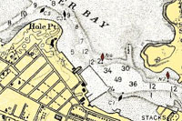
| Hole in Rock |
|
| Hole Point |
|
| Houghs Neck |
| • |
USGS identified - MassMapper MassGIS |
| • |
Google Maps | Google Earth - Google |
| • |
Houghs Neck 350 Years (PDF)/Internet Archive, "..It was named for Atherton Hough, a Bostonian, who received it as a part of a land grant from the town of Boston...Mr. Hough never lived on the peninusla but farmed it through tenant farmers and leases, setting a farming pattern that continued for over two hundred years...", Quincy History Society Newsletters (Internet Archive), 1986 - Thomas Crane Public Library |
| • |
"...HOUGH, or HAUGH :— Atherton Hough, had been mayor of Boston, in Co. Lincoln 1628, and an alderman there 1633, when he resolved to come with his minister, famous John Cotton, and arrived with wife Eliz. in the Griffin that year ; freeman 1634, chosen Assistant 1635, left out in 1637 as of Antinomian tendency, and chosen represent,
for Boston at the same, and following courts ; his wife died 1643, and he took another at Wells, died 1650, leaving widow Susanna and son Rev. Samue...", Genealogical Guide to the Early Settlers of America, Vol. 2, pg. 2688, Henry Whittermore, 1898 - HathiTrust |
| • |
"...4 January, 1636. 'It is agreed by general consent that Mr. Atherton Haughes shall have six hundred acres laid him out beyond Mount Wollaston, from between Monottyquot river to the bound that parts our bound from Weymouth...", An Historic Guide to Cambridge, pg. 58, An Address on the Occasion of Opening the New Town Hall in Braintree, Charles F. Adams, 1858 - Internet Archive |
| • |
"...Mr. Atherton Haugh was a man of means, assistant to the General Court, 1635-36, and later deputy. He lived in the neck - now the Haugh farm - purchasing adjoining lots till in 1642 it contained three hundred acres but before that time he had returned to Boston to live. He died in his house on the corner of Washington and School streets and the estate fell to his son, Rev. Samuel Haugh, who left it to his son, Samuel, who died leaving it much encumbered...", An Historic Guide to Cambridge, pg. 181, Daughters of the American Revolution, 1907 - Google ebook |
| • |
"...On the west side on the south corner of School Street was the house lot of Atherton Hough, granted to him on his arrival in 1633 in the same ship that brought John
Cotton and others. Hough was one of the selectmen, and with Vane and Elder Oliver were the first appointed to argue disputes...", The Crooked & Narrow Streets of the Town of Boston 1630-1822, Pg. 160, Annie H. Thwing, 1920 - Internet Archive |
| • |
Old Braintree, A Parent Town (PDF)/Internet Archive, "..Thomas Faxon was an early settler in Old Braintree, first as a tenant farmer on Atherton Hough's land grant. In 1656 he bought his farm from Mr. Hough's heirs. In 1660 he was one of eight men who met in Roxbury to consider the purchase of Block Island...", H. Hobart Holly, Quincy History Society Newsletters (Internet Archive), 1986 - Thomas Crane Public Library |
| |
Atherton Hough, "...Jan. 4, 1635, Mr. Hough (1643) was granted by the town of Boston six hundred acres of land at Mount Wollaston, which grant was soon after increased to seven hundred acres...", History of the Military Company of the Massachusetts, now called the Ancient and Honorable Artillery Company of Massachusetts, 1637-1888, pg. 131, 1895 - Internet Archive |
| • |
Atherton Hough - Genealogy.com |
| • |
Houghs Neck (Cape) - USGS Geographic Names Information System |
|
| Kitchamakin Hill |
|
| Little Dome |
|
| Moon Head |
|
| Moon Island |
| • |
USGS identified - MassMapper MassGIS |
| • |
Google Maps | Google Earth - Google |
| • |
"...Moon Island, now connected to the mainland by the earth and gravel brought here from Half-Moon Island, was formerly
called Manning's Moone, and in 1656 was valued at 28 pounds...", The Islands of Boston Harbor, pg. 182, Edward R. Snow, 1935 - HathiTrust |
| • |
"... Edmund Munnings, aged 40, came to New England in 1635, in the Abigail...bringing with him his wife Mary, aged 30 years, daughters Mnry and Anna, and son Mahalaleel, respectively nine, six and three years of age. He settled in Dorchester, where be had grants of land, among them that of Moon Island, "layd to Dorchester" by the General Court, June 2, 1641. This Island contained about twenty acres of land, and was used for pasturage, it may have been, for two and a half centuries. On the northerly side was a high bluff; southerly it was connected at very low water, by the bars or flats of the island, with the promontory of Squantum. This island is named on the Dorchester Records, in 1637 and 1638, "Mannings Moone." It is, however, no longer an island, having recently been joined to Squantum by an artificial isthmus in connection with the great Boston sewer, the reservoir of which is being built here..", Genealogical Gleanings in England, Vol. 1, pg. 10, Henry F.G. Waters, 1885 - HathiTrust |
| • |
History of Moon Island, "... In 1878, Boston began construction of a giant 7% foot diameter sewer from Columbus Park to Squantum beneath Dorchester Bay, and from Squantum to MoonIsland under the connecting causeway. On Moon Island itself, the city constructed four huge granite storage tanks, with a combined capacity of 50 million gallons, to hold raw sewage. Twice a day gates were opened permitting the detained wastewater to flow into the Harbor with the outgoing tide..", Supplemental Draft Environmental Impact Statement of the Siting of Wastewater Treatment Facilities in Boston Harbor, Vol. 2, pg. 7, U.S. Environmental Protection Agency, 1985 - HathiTrust |
| • |
"... Moon Island is one of the most marked objects in
the southerly part of the harbor, on account of the high
bluff which it presents on its northerly side. In form
on the charts, it looks very much like a leg of venison
with its shank pointing westerly as a bar towards
Squantum..", A Topographical and Historical Description of Boston, pg. 507, Nathaniel Shurtleff, 1885 - HathiTrust |
| • |
Moon Island, "...In colonial times, the island was known as Manning's Moone, and was mainly used for grazing and farming. On June 2, 1641, by order of the General Court of Elections in Boston, Moon Island came under the jurisdiction of the Town of Dorchester...." - Friends of the Boston Harbor Islands |
| • |
Moon Island (Island) - USGS Geographic Names Information System
Variant names: Mennens Moon, Mennens Moone |
|
| Mosswetusset Hummock |
| • |
USGS identified - MassMapper MassGIS |
| • |
Google Maps | Google Earth - Google |
| • |
"...Moswetuset Hummock is one of he oldest recognized historical sites in the nation as well as in the Commonwealth of Massachusetts...", Moswetuset or Massachusetts Hummock, Part. 1, Part. 2, Part 3. (PDF), James R. Cameron, Quincy History Society Newsletters, 1974, - Thomas Crane Library |
| • |
Meswetuset Hummock (PDF)/Internet Archive, "...Moswetuset Hummock ...The name Moswetuset means roughly 'Place of the House of the Great Sachem.' Some records refer to it as Massachusetts Hummock or Massachusetts Hill...", James R. Cameron, Quincy History Society Newsletters (Internet Archive), 1986 - Thomas Crane Public Library |
| • |
The Meswetuset Hummock (Internet Archive Wayback Machine), "...The thickly-wooded hill was the summer seat of the tribe’s Sachem Chickatabot because of its view of the surrounding area and proximity to the bay, salt marshes, and the Blue Hills...." - Eastern Nazarene College |
| • |
"...The hill, or hummock, still called Sachem's Hill, lies in the northerly part of what is now Quincy, near Squantum, and tradition points it out as the seat of the Sachem who ruled the Massachusetts Indians...", Pattee, pg. 308, 1878 - Internet Archive |
| • |
Mosswetusset Hummock (Island) - USGS Geographic Names Information System
Variant name: Moswetusett |
|
| Mount Ararat |
| • |
Google Maps | Google Earth - Google |
| • |
"...Mount Ararat is a large and lofty hill, and is among the parcels of land, lately presented to the town, by the Hon. John Adams..", Pattee, pg. 50, 1878 - Internet Archive |
| • |
"...Perhaps the most singular circumstance connected with the subsequent fate of the North Common was that a large portion of it, including that region immemorially known as Mount Ararat, in which the leading Quincy stone quarries have since been developed, was afterwards bought by John Adams himself...", Adams, pg. 50, 1891 - Internet Archive |
| • |
Diary of John Adams, Volume 3 (Internet Archive), "...Mount Ararat was part of the old Braintree North Commons (now in West Quincy), divided and sold as lots in 1765 under the management of a town committee of which John Adams was a member..." - The Adams Papers, Massachusetts Historical Society |
| • |
Map of the city of Quincy, Norfolk County, Massachusetts, Ernest W. Branch, Civil Engineer, 1907 - Norman B. Leventhal Map Center, Boston Public Library |
| • |
Likely reference to Biblical Mount Ararat - Wikipedia |
|
| Mount Wollaston - See Mount Wollaston (historic) and Wollaston Heights |
| • |
USGS identified - MassMapper MassGIS |
| • |
Google Maps | Google Earth - Google |
| • |
Wollaston as it was in 1870 (PDF), "..Wollaston Hill, about 1870. This view is from the intersection of the present Standish Avenue and Warren Avenue Extension. On the skyline may be seen the nearly framed-up house that was being built for Quincy A. Faunce at 109 Grandview Avenue...", D. Foster Taylor (1946), Quincy History Society Newsletters, 1990 - Thomas Crane Public Library |
| • |
Wollaston "...Wollaston, Massachusetts, is a neighborhood in the city of Quincy, Massachusetts. Divided by Hancock Street/Route 3A, the Wollaston Beach side is called Wollaston Park, while the Wollaston Hill side is called Wollaston Heights..." - Wikipedia |
| • |
Mount Wollaston - USGS Geographic Names Information System |
|
| Mount Wollaston (historic) - See Mount Wollaston and Wollaston Heights |
| • |
Google Maps | Google Earth - Google |
| • |
"... Mount Wollaston or the Merry-Mount of Thomas Morton. This farm of 600 acres was
the homestead of Col. John Quincy, in whose honor the Town received its name. On the north slope of this elevation was located the ancient Cedar Tree, which is the salient feature in the seal of the City of Quincy...", Quincy Historical Society Route Map, pg. 15, 1921 - Internet Archive |
| • |
Wollaston and Morton (PDF), "...His [Thomas Morton} stay here is commemorated by the name Ma-re-Mount, now Merrymount, the name he gave to the hill that had been Mount Wollaston...", H. Hobart Holly, Quincy History Society Newsletters, 1995 - Thomas Crane Public Library |
| • |
"...In 1620, Captain Wollaston, with about thirty others, came over from England, and began a plantation, not far from that already begun by Mr. Weston. To this they gave the name of Mount Wollaston, from a neighboring hill...", Pattee, pg. 308, 1878 - Internet Archive |
| • |
Notes on the History of Mt. Wollaston, 19 October 1802, "...In 1625 one Capt. Wollaston with about 30 Persons began a Plantation near Westons. They gave it the name of Mount Wollaston. It was known by that name some years after, but at length the name was lost in that of Braintree, of which Town it is a part. The particular Hill, which caused the name of Mount is in the farm of John Quincy Esq late one of the council for the Province..." - Founders Online, National Archives |
|
| Nahanton Hill |
|
| North Boyce Hill |
|
| North Commons |
| • |
Google Maps | Google Earth - Google |
| • |
The North Common Quarry Lands (PDF), "..In the days when granite was bringing' prosperity and fame to Quincy, the quarrying activity was centered in two areas: the hills of West Quincy and the North Common area around present Quarry Street...", H. Hobart Holly, Quincy History Society Newsletters, 1990 - Thomas Crane Public Library |
| • |
Map of the city of Quincy, Norfolk County, Massachusetts, Ernest W. Branch, Civil Engineer, 1907 - Norman B. Leventhal Map Center, Boston Public Library |
|
| Nut Island |
| • |
USGS identified - MassMapper MassGIS |
| • |
Google Maps | Google Earth - Google |
| • |
Nut Island Headworks - MWRA |
| • |
"...The first mention we can find of Nut Island is on August 5, 1680, when Obediah Walker sold two-thirds of the Island to Richard Harris. At this time the Island was also called Hoffs Thumb, because it was off the shore from Hoffs Neck, now known as Hough's Neck...", The Islands of Boston Harbor, pg. 183, Edward R. Snow, 1935 - HathiTrust |
| • |
"...April 30th, 1793. It was voted at this meeting that a drift-way should be laid out to Nut Island...", Pattee, pg. 89, 1878 - Internet Archive |
| • |
Nut Island, "...The Island has had many names in history. According to the book The Houghs Neck Story old maps have the name listed as Houghs Tomb and Hoff’s Thumb, both of these names harken back to the original owner of the land Atherton Hough who, interestingly enough, never lived on this land but rent it as a farm..." - Rev. Peter M Preble |
| • |
The Nut Island Effect, When Good Teams Go Wrong, "...Nut Island is actually a small peninsula in Quincy, Massachusetts, a mostly blue-collar city of 85,000 located about ten miles south of Boston. Sitting at the southern entrance to Boston Harbor, Nut Island was a favorite landmark for seventeenth-century sailors, who savored the scent of what one early European settler called the “divers arematicall herbes, and plants” that grew there. “Shipps have come from Virginea where there have bin scarce five men able to hale a rope” the settler wrote “untill they come [near Nut Island], and smell the sweet aire of the shore, where they have suddainly recovered.”...", Paul F. Levy, 2001 - Harvard Business Review |
| • |
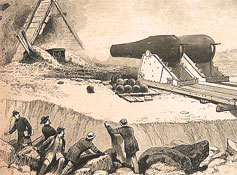
The Nut Island Experiments with Great Guns, "...The guns mounted on Nut Island, in 1873, were two 15 inch guns, weighing 43,000 pounds each made, by the South Boston Iron Company, and a pattern differing somewhat from the army and navy gunsof the same caliber. One was rifled on the Wiard plan the other an original smooth bore...", Report of the Select Committee on Heavy Ordnance Projectiles, pg. 135, U.S. Senate, 1883 - Google ebook |
| • |
Nut Island Headworks, Massachusetts Water Resources Authority - MWRA Online |
| • |
Nut Island (Cape) - USGS Geographic Names Information System |
|
| Passanageset Knoll |
| • |
Google Maps | Google Earth - Google |
| • |
Moswetuset Hummock (PDF), "...Before the plague, Chicataubut had his seat at Passanageset Knoll, a piece of high ground in the Broad Meadows saltmarsh area of Town River Bay near Merrymount. It was generally back of the present Our Lady of Good Counsel Church on Sea Street. It has been excavated and removed for its gravel...", James R. Cameron, Quincy History Society Newsletters, 1994, - Thomas Crane Library |
| • |
Passanageset Project, "“Before the plague, Chickataubut had a seat here at Passanageset Knoll, a piece of high ground here in Broad Meadows salt marsh near Merrymount. It was generally back of the present Our Lady of Good Counsel Church on Sea Street."", - Passanageset Project |
|
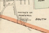
| Penns Hill |
| • |
USGS identified - MassMapper MassGIS |
| • |
Google Maps | Google Earth - Google |
| • |
"... The Pennimans resided in this neighborhood as Joseph bought an estate in this vicinity as early as 1675 from Mr. William Needham after whom the hill was named...", The Penniman Family, 1631-1900, pg. 13, (George W. Penniman, c.1900) George D. Penniman, Jr., 1981 - Internet Archive |
| • |
"...Pen's hill is an abbreviated name, given to a high hill between Quincy and Braintree, from the family of Penniman, once large owners of land thereabouts..", Pattee, pg. 50, 1878 - Internet Archive |
| • |
"... To the southwest was a prominent knob known as Pine Hill, dominated by red cedar. To the east, Penn’s Hill (alternately called Payne’s Hill) received its name from William Penn, a local landowner who established part of his homestead on its slopes..", Cultural landscape Report for Adams Birthplaces, Adams National Historical Park, pg.13 (PDF), Olmsted Center for Landscape Preservation, 2014 - National Park Service |
| • |
Payne's Hill or Penn's Hill, Map of the city of Quincy, Norfolk County, Massachusetts, Ernest W. Branch, Civil Engineer, 1907 - Norman B. Leventhal Map Center, Boston Public Library |
| • |
Penns Hill - USGS Geographic Names Information System |
|
| Philip Head |
| • |
USGS identified - MassMapper MassGIS |
| • |
Google Maps | Google Earth - Google |
| • |
"...They purchased glass works wharf and about 100 acres of land, with the bluff known as Phillips Head, which extends into the river above the glass works wharf. Across this headland is a row of immense old willow trees said to have been planted by the Indian, King Philip, and here his tribe feasted and had clam bakes...", Crane, New England Magazine, pg. 173, 1910 - Google ebook |
| • |
Philip Head (Cape) - USGS Geographic Names Information System |
|
| Pine Island |
|
| Presidents Hill |
| • |
USGS identified - MassMapper MassGIS |
| • |
Google Maps | Google Earth - Google |
| • |
"...President's hill is a beautiful eminence, so called from its being, a great part of it, the property of the second President of the United States. The title seems to be well appropriated, since it has now become the property of another President...", Pattee, pg. 50, 1878 - Internet Archive |
| • |
President's Hill - Hospital Hill - Cranch Hill "...In the 18th century, the area now known as Presidents Hill was pasture land and was commonly referred to as "Stony Field." The area was renamed "Presidents Hill" as the result of its subsequent ownership by John Adams..." - Massachusetts Cultural Resource Information System (MACRIS) |
| • |
Richard Cranch (1726-1811) "...In 1792 [Richard Cranch] was asked to furnish a name for the new town and he proposed Quincy in honor of Col. John Quincy which was accepted.... He married Nov. 25, 1762 Mary Smith, sister of Abigail wife of President John Adams..." - Geni.com |
| • |
Quincy says goodbye to hospital ‘up the hill’, "...As with almost everything in Quincy, there’s history here. Before it was Hospital Hill, it was Cranch Hill: Richard Cranch, who married Abigail Adams’s sister, owned a farm on the site. Before that, it was President’s Hill: John Adams owned the land...", Nov.29, 2014 - Boston Globe |
| • |
Presidents Hill - USGS Geographic Names Information System |
|
| Quarry Hills |
| • |
Google Maps | Google Earth - Google |
| • |
The Quincy Quarry Rail Road 1893-1918 (PDF), "...In 1893 a group of granite manufactures decided to build a railroad to open the quarry lands in West Quincy that border the Blue Hills. For many years prospectors had been aware of the vast amount of dark blue granite hidden away in that long range of hills that form the backbone of West Quincy....
By 1968 the city of Quincy had run out of quarries in the north common and began to fill the remaining ones at what is now called Quarry Hills..." - Quincy Quarry And Granite Workers Museum |
| • |
Welcome to the Quincy Quarries Historic Site (PDF), "...Today the Quincy Quarries Historic Site preserves a rich industrial landscape while providing a unique open space for recreation and discovery..." - DCR, Commonwealth of Massachusetts. |
|
| Quincy Great Hill |
| • |
USGS identified - MassMapper MassGIS |
| • |
Google Maps | Google Earth - Google |
| • |
"...Great Hill, the termination of a strip of land called Hough's Neck, from
Atherton Hough, one of the original settlers of Boston, who had a grant of land
at Mount Wollaston...", Pattee, pg. 308, 1878 - Internet Archive |
| • |
"...The Neck ends at Great Hill, a round and swelling grassy dome, ninety-four feet high, with a very broad and charming
view over the harbor and outer sea...", Sweetser, pg. 95, 1889 - HathiTrust |
| • |
"...At the inshore end of this road, over the old Nut island bar, rises Mears Great Hill which stands like a sentinel and guards the entrance to Quincy's southern shore...", Crane, New England Magazine, pg. 172 , 1910 - Google ebook |
| • |
Excerpts from the Diary of Hattie L. Mears (PDF), "..James Mears purchased from the estate of Thomas Taylor the Great Hill area of Houghs Neck. From then until 1892 he was the Proprietor of the Great Hill House, a popular hotel there...", Ruth H. Wainwright, Quincy History Society Newsletters, 1990 - Thomas Crane Public Library |
| • |
Quincy Great Hill - USGS Geographic Names Information System |
|
| Railway Hill |
| • |
Google Maps | Google Earth - Google |
| • |
"...The quarries of Quincy granite are near West Quincy, where the hills are almost honeycombed with quarry-holes. Here is Railway Hill, where may be seen remains of what is claimed to be the first railroad in America, built about 1826 to convey the stone to tide-water. This hill is now a mere shell, from the edge of which we look into a deep abyss. The summit long ago disappeared, and far below the spot where once stood a stone observatory, we see the quarrymen still excavating...", The Blue Hills, E.G. Chamberlain, Appalachian Mountain Club, Appalachia, Vol. 3, pg. 122, 1882 - HathiTrust |
| • |
Blue Hills Reservation; Massachusetts, E.G. Chamberlain,1885 - Olmstead Archives, NHS, NPS |
|
| Rattlesnake Hill |
|
| Rock Island Head |
|
| Rufes Hummock |
|
| Shipyard Point |
| • |
USGS identified - MassMapper MassGIS |
| • |
Google Maps | Google Earth - Google |
| • |
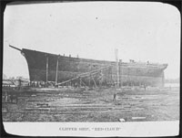
Waterfront, Southerly Section, "..The clipper ship “Red Cloud” built on the land known at various times as Bents Point, Shipyard Point, and now called Powerhouse Point, situated on the Weymouth Fore river at the entrance to Town River...", Warren S. Parker - Thomas Crane Public Library |
| • |
Quincy Point As I Knew It Maritime (PDF), "...At the lower end of Wharf Street was where people went to cross over to Germantown in the little ferry...", Joseph L. Whiton, Quincy History Society Newsletters, 1986 - Thomas Crane Public Library |
| • |
Quincy's Shipbuilding Heritage - Thomas Crane Public Library |
| • |
A History of Shipbuilding at Fore River, "...History records that shipbuilding has been carried on in the Quincy area since 1696 when the ketch Unity was launched from Ship's Cove (Quincy Neck)...", Anthony F. Sarcone, Lawrence S. Rines, 1975 - Thomas Crane Public Library |
| • |
History of Shipbuilding in Quincy, "...On September 21, 1789, the 116 ft. MASSACHUSETTS was launched from Germantown. It was the largest mercantile vessel built in North America. Several clipper ships were built locally, the RED CLOUD built in 1877 at the Thomas Shipyard was the final clipper ship built (site of the former Procter & Gamble Company)...", USS Salem CA-139 - United States Naval Shipbuilding Museum |
| • |
Shipbuilding Quincy's Largest Industry, Historic Quincy Massachusetts, Chp. 17, William C. Edwards, 1957 - Thomas Crane Public Library |
| • |
South Shore Maritime-A Brief History (PDF), H. Hobart Holly, Quincy History Society Newsletters, 1988 - Thomas Crane Public Library |
| • |
Power Generating and Distributing System of the Old Colony Street Railwayl, "...The main station at Quincy Point contains five Curtis vertical steam turbines, each of 2000 kw normal capacity, and each direct connected to an alternating generator delivering threephase 25 cycle 13,200 volt current. This station by the way was the first plant of its kind in this country to use steam turbines exclusively for electric railway purposes...", Street Railway Journal, pg. 1022, 1905 - Google ebook |
| • |
Procter & Gamble Manufacturing, "...The location of the factory on Quincy Point, where the Town and Fore rivers
converge, offers the plant excellent wharf facilities for unloading raw materials, while rail access to the former Old Colony's Railroad's South Shore Division is provided by the Fore River Railroad (also serving the General Dynamics shipyard). The plant incorporates the former powerhouse of the Old Colony Street Railway Company, built in 1901/1902..." - Massachusetts Cultural Resource Information System (MACRIS) |
| • |
About Twin Rivers Technologies (PDF), "...Twin Rivers Technologies (TRT) was founded in 1994. The Quincy, MA site, previously owned and operated by Procter & Gamble, was acquired by the original Twin Rivers Limited Partnership. In 2007, TRT was purchased by Felda Global Ventures..." - Twin Rivers Technologies |
| • |
Shipyard Point (Cape) - USGS Geographic Names Information System |
|
| Slide Notch |
|
| Southeast Ridge |
|
| Squantum |
| • |
USGS identified - MassMapper MassGIS |
| • |
Google Maps | Google Earth - Google |
| • |
"... take second left into Huckins Avenue, passing the Squantum School-building on the left, and along to Bellevue Avenue; then turn left to top of Squantum Hill, where a magnificent view of the surrounding country and the Harbor is laid out before one...", Quincy Historical Society Route Map, pg. 27, 1921 - Internet Archive |
| • |
Squantum (Cliff) - USGS Geographic Names Information System
Variant name: Massachusetts Hill |
|
| Squantum Peninsula |
|
| Squantum Point |
|
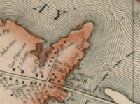
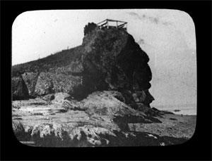
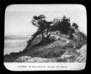
| Squaw Rock |
| • |
USGS identified - MassMapper MassGIS |
| • |
Google Maps | Google Earth - Google |
| • |
"... Squaw Rock, at the extreme end of the peninsula; a clearly defined profile of an Indian Head may be seen at the outer end of this rock...", Quincy Historical Society Route Map, pg. 28, 1921 - Internet Archive |
| • |
"...The area is named Squaw Rock because some see a silhouette of a native american's face in the rock foundation...", Pepe, pg. 36, 2008 - Internet Archive |
| • |
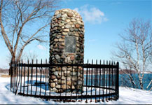
Miles Standish Cairn, "...The Myles Standish Cairn was erected in 1895 to commemorate his visit here with a party from Plymouth on September 30, 1621, the first recorded visit of white men to this locality...", - Massachusetts Cultural Resource Information System (MACRIS) |
| • |
Squaw Rock (Island) - USGS Geographic Names Information System |
|
| The Broken Hills |
|
| The Crags |
|
| Tucker Hill |
|
| Wampatuck Hill |
|
| Wollaston Heights - See Mount Wollaston and Mount Wollaston (historic) |
| • |
Google Maps | Google Earth - Google |
| • |
Wollaston Hill, "...The Wollaston Land Company was established in 1870 for the purpose of developing Wollaston Heights (now called Wollaston Hill) which was a portion of the tract, including 600 acres, allotted in 1636 by the town of Boston to William Hutchinson, the husband of mistress Anne Hutchinson, the most important woman in the early history of Massachusetts...", - Massachusetts Cultural Resource Information System (MACRIS) |
| • |
Wollaston as it was in 1870 (PDF), "..Wollaston Hill, about 1870. This view is from the intersection of the present Standish Avenue and Warren Avenue Extension. On the skyline may be seen the nearly framed-up house that was being built for Quincy A. Faunce at 109 Grandview Avenue...", Quincy History Society Newsletters, 1985 - Thomas Crane Public Library |
| • |
Wollaston, "...Wollaston, Massachusetts, is a neighborhood in the city of Quincy, Massachusetts. Divided by Hancock Street/Route 3A, the Wollaston Beach side is called Wollaston Park, while the Wollaston Hill side is called Wollaston Heights..." - Wikipedia |
|
|
|
 |
|
 |
|
 |
|
 |
|
 |
|
 |
|
 |
|
| Forbes Hill |
 |
|
 |
|
| Germantown Point |
 |
|
| Hole Point |
 |
|
| Moswetuset Hummock |
 |
|
| Mount Wollaston (historic) |
 |
|
 |
|
 |
|
 |
|
| Penns Hill |
 |
|
| Shipyard Point |
 |
|
 |
|
| Squaw Rock |
 |
|
 |
|
| Wollaston Heights |
 |
|
| |
| |
| |
| |
|
|
| More about Quincy's USGS-listed hills |
| |
Quincy has 41 USGS-listed hills, more than any other town or city in the Boston Basin. Several factors contribute to this high number. First, 18 of the hills are in the Blue Hills Reservation where there are a lot of hills, and most have been named. Second, Quincy has three peninsulas that extend into the greater Boston Harbor. They contain a collection of USGS-listed capes, heads, points, necks, rocks, islands now connected to the mainland, and one hummock. |
| |
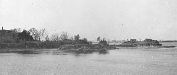
One the three peninsulas, Squantum, has a monument on it that reads, “Captain Myles Standish, with his men, guided by the Indian Squanto landed here September 30, 1621.” Installed by the Daughters of the Revolution (note, a different group than the Daughters of the American Revolution), it marks the location of what is thought to be the first recorded landing by Europeans in Boston Harbor. Most sources consider it likely that there was early contact. John Smith visited he harbor in 1614, and later produced a map showing many features of the harbor including a river he named the Charles River (the Native American name was Quinobequin, often translated as meandering or winding water). Other sources speculate that explorers, fishermen, and traders from Portugal, France, and Italy could have visited the harbor as early as the 1500s. Even maybe the Vikings. The full name of Squanto from the monument was Tisquantum,1 a Native American in the Patuxet tribe. He had been abducted by the English by 1614 or possibly earlier, sold into slavery in Spain, then escaped or was smuggled to England by 1618. Fluent by then in English, he was soon back in New England acting as a negotiator and interpreter for early unsuccessful English colonization efforts. Left in New England, he was living near the site of his old village when in 1620 the Pilgrim settlers decided to make that location their new home. Acting as an intermediary between the Pilgrims and the Native Americans, he was instrumental in the friendship treaty that the two signed. By most accounts, Squantum was named for him. The USGS lists three hill-like features with Squantum in their name. They are, Squantum (79 ft. Cliff), Squantum Peninsula (7 ft. Cape), and Squantum Point (0 ft. Cape). |
| |
One the three peninsulas, Squantum, has a monument on it that reads, “Captain Myles Standish, with his men, guided by the Indian Squanto landed here September 30, 1621.”2 Installed by the Daughters of the Revolution (note, a different group than the Daughters of the American Revolution), it marks the location of what is thought to be the first recorded landing by Europeans in Boston Harbor. Most sources consider it likely that there was early contact. John Smith visited he harbor in 1614, and later produced a map showing many features of the harbor including a river he named the Charles River (the Native American name was Quinobequin, often translated as meandering or winding water). Other sources speculate that explorers, fishermen, and traders from Portugal, France, and Italy could have visited the harbor as early as the 1500s. Even maybe the Vikings. The full name of Squanto from the monument was Tisquantum, a Native American in the Patuxet tribe. He had been abducted by the English by 1614 or possibly earlier, sold into slavery in Spain, then escaped or was smuggled to England by 1618. Fluent by then in English, he was soon back in New England acting as a negotiator and interpreter for early unsuccessful English colonization efforts. Left in New England, he was living near the site of his old village when in 1620 the Pilgrim settlers decided to make that location their new home. Acting as an intermediary between the Pilgrims and the Native Americans, he was instrumental in the friendship treaty that the two signed. By most accounts, Squantum was named for him. The USGS lists three hill-like features with Squantum in their name. They are, Squantum (79 ft. Cliff), Squantum Peninsula (7 ft. Cape), and Squantum Point (0 ft. Cape). |
| |
Along with the three hill-like USGS features with Squantum in their name, there are three more “hills” that are associated with that first contact. They are, Chapel Rocks (0 ft. Bar), Mosswetusset Hummock (26 ft. Island), and Squaw Rock (39 ft. Island).3 In 1621, Myles Standish was looking for a sachem of the Massachusetts tribe. The woman they met was a Wampanoag, and she gave them directions to her local sachem, Obbatinewat, who that day was on Savin Hill, or possibly Dorchester Heights. The home of the Wampanogs was in southern Massachusetts, not in the southern part of Boston harbor, the ancestral home of the Massachusetts. The Pilgrims had arrived in New England at a calamitous time for the Native American population in southeastern Massachusetts. A series of plagues from 1614 to 1620 had been devasting. Mortality rates in places were 90%. Whole tribes were wiped out. Squanto is thought have been the last from the Patuxet tribe to have ever lived. Traditional boundaries were likely of less importance to people who were struggling to merely survive and deal with aggressive neighbors less affected by the plagues. It is not known how far Standish and his party walked landward that day before meeting the Wampanoag woman. But almost exactly one mile away from the place where they landed was the summer home of the Massachusetts sachem, Chickatawbut. Mosswetusset Hummock is small hill that except for now being covered by trees, likely looks much like it did in 1621. It is not known if Chickatawbut was there that day |
| |
Chapel Rocks and Squaw Rock are near the spot where Standish landed, and are part of the same outcropping of bedrock known as Squantum Tillite, a type of Roxbury Puddingstone. They were not named in Edward Winslows's 1621. Mourt’s Relation,4 and their first mention in a 1632 Dorchester court document adds to the confusion on how they were named. In the fall of that year, Roger Ludlow (1590-1664) received 100 acres of land between “Musquantum chappell” and the mouth of the Neponset river, leading to the area initially being called Ludlow’s Point. Musquantum has been translated as meaning “god is angry,” and some suggest that is where the name for Squantum comes from. For Chapel Rocks, their vertically stacked shape is most given as a reason for their name. More fanciful reasons have been given for how Squaw Rock got its name. The most common is that a profile of a Native American woman can be seen when viewed from a specific angle. Thomas Morton (c.1579-1647), who will play a key role in the first settlement of Mount Wollaston in Quincy, in 1628 called the rock formation, “Squanto’s Chapel,” and warned that if you drank the water from a fountain there, you would fall asleep for 48 hours. One of the oddest appears in a 1937 WPA Federal Writers' Project guide book which says, “According to one tale, an Indian woman fell into the sea from the rock, which then became known as Squaw Rock and the whole district was called Squaw Tumble or Squan-Tum.” |
| |
Moon Island off the end of Squantum was an island when Myles Standish sailed by in 1621. Moon Head (39 ft. Cliff) and Moon Island (43 ft. Island) were connected by a causeway to the mainland in 1878 as part of a major wastewater treatment effort. The island was named for Edmund Munnings who was granted the land for use as pasture in 1641. |
| |
The USGS lists two hills in Quincy with Wollaston in their names, Mount Wollaston (121 ft.) and Wollaston Heights (82 ft.). Mount Wollaston is location of the first settlement in what would become Quincy and is named for Richard Wollaston. With very little known about Wollaston, his life, or the event, the various narratives that have been written about him range from either praising his accomplishment, to downplaying his importance. He and his group of men are thought to have arrived in January 1625. Wollaston would leave for Virginia before spring and never return. The actions of the man who took over the small colony next, Thomas Morton (c.1579–1647), was be so despised by the Puritans of the time that Wollaston’s reputation, good or bad, would be ignored. Recent research into what Wollaston was doing in New England waters in late 1624 raises the question of if he was even planning on starting a colony. While given the title captain, Wollaston was not captain of the ship, he was in charge of the men the ship was transporting. Those men were indentured servants, but not the type who are bound to master to learn a craft. These were men, some convicted criminals, who were being sent to work in the fishing industry in the summer, and then be delivered to Virginia to work on the tobacco farms. |
| |
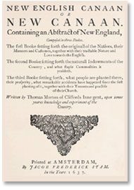
What Thomas Morton’s connection was to Richard Wollaston is not known for certain. Initially it was thought they landed at Mount Wollaston. Now it appears that Morton arrived just after Wollaston left. He was well educated, a lawyer, and a man of some means. It is thought that he arrived in New England possibly as early as 1622 as member of one of the failed colonization attempts at Weymouth. In 1625 Morton arrived at Mount Wollaston and convinced the indentured servants still there to expel the man Wollaston had put in charge and follow him. With a promise of freedom, they did. Now renamed Ma-re Mount (a pun using the Latin words for sea and mountain) or Merrymount, for the next three years the men of traded alcohol and firearms for furs with the local tribes, and famously erected a maypole - in keeping with old rural English customs - around which they drank liquor, sang bawdy songs, and danced with their Algonquian neighbors. The Pilgrims in Plymouth, and the Puritans in Boston, could not tolerate such “pagan” behavior and Morton was arrested, tried, convicted and banished to an island and left to die. Fed by local Native Americans, Morton would escape to England where he had support among politicians who were frustrated with the Puritans. The book he wrote, New English Canaan, criticized the Puritans for their policy of land enclosure that benefited the wealthy, and near genocide of the Native Americans. Remarkably, his lawsuit would lead to the Massachusetts Bay Company having its charter revoked. Politicians in New England would ignore the decision, but it did lead to greater isolation of the colony. Morton would return to New England, be tried and imprisoned again, then released to spend his last days in a royalist settlement in Maine. |
| |
In Quincy, the name Wollaston is affixed to much more than a small hill. In other categories, the USGS lists a Wollaston channel, cemetery, train station, beach, post office, fire department, school, library branch, theater, several churches, and yacht club. All for a man who local Quincy historian H. Hobart Holly described as, “of minor importance, and whose stay here was very short.”5 He believed reason for its wide use was the selection of Wollaston Heights as the name of a new train station on line then recently extended into Quincy. A Wollaston Land Associates company was not far behind offering lots on an undeveloped hill they also called Wollaston Heights. The real estate development company arranged a deal with the railroad company where anyone buying a lot would receive free passes good for three years on the train. Another possibility was use of the name Mount Wollaston for the area before it called Braintree, and then later Quincy. An apparent, but unusual discrepancy in the USGS information is the location of the original Mount Wollaston. Historic town and county maps, and NOAA nautical charts, identify a Mount Wollaston and place it just south of the Black’s Creek inlet, not at the USGS location near Forbes Hill. The Quincy city seal contains a drawing of a tilted old cedar tree that was supposed to have been on Mount Wollaston when Wollaston first arrived. The tree was is recorded as being on the John Q. Adams estate shown in the 1897 George W. Stadly & Co. Quincy atlas. The tree blew down in a storm in 1898, and there is a picture of the fallen tree in the Adams estate. While the name Wollaston lives on, Thomas Morton, on the other hand, is only honored with a small plaque in the Mount Wollaston cemetery wall. |
| |
USGS-listed Houghs Neck (23 ft. Cape) was named for Atherton Hough (c.1593-1650). He had been mayor of Boston in England before immigrating in 1633. He first lived in Charlestown and moved to Boston in 1635. That year Hough also was granted the land that would become known as Hough’s Neck in what was then Braintree. He also received land in East Cambridge. Both properties were used as farms. He served as assistant to the general court and as a selectman. USGS-listed hills on Houghs Neck are Nut Island (10 ft. Cape), Quincy Great Hill (92 ft.), and Rock Island (0 ft. Cape). Great Hill is a name early settlers would give to a hill they thought was the tallest in the town. Hingham, Hull, Malden, Weymouth, all have, or had, a Great Hill. The name Nut Island was used in 1637 by Thomas Morton in his, The New English Canaan, but he does not say where the name came from. The island, later also called Hough’s Thumb, was reachable at low tide and was used for grazing animals. In 1793 a causeway was building connecting the island to Squantum. In the middle of the 1800s the island was used as a proving ground for Army ordinance. Large cannons pointed towards the end of Peddock’s Island would be fired at metal targets. An incident in September of 1874 likely lead to end of the use of the island for that purpose. In testimony before the U.S. Congressional report the gun’s inventor, Norman Wiard, reported a test where the projectile had passed over the target a mile away, skipped across the water and landed in Hull four miles away, “greatly endangering life, and causing alarm to the inhabitants.” Rock Island is name for another outcropping of bedrock similar to nearby Chapel Rocks on Squantum. An 1897 map shows the island reachable by a road. |
| |
The other USGS-listed peninsula in Quincy is Germantown Point (10 ft. Cape). An early name of the area was Sheds Neck. That for Daniel Shedd (c.1620-1708). There is no record of his passage to New England, but he is recorded as being “of Brantre” in 1643. The land he lived on, in what was then Braintree, had been granted to William Thompson, the first pastor of the Braintree church. In 1658 Shedd was granted his own land in Billerica and moved there with his family. That family included seven children. His first wife had died just before he moved, he married again having four more children. Billerica had recently been settled and the increasing numbers of people looking for land was leading to increased tensions with Native Americans. Members of Shedd family would be killed by Native Americans in the 1690s. Descendants of Daniel Shedd include J. Herbert Shedd (1834-1916). He was a civil engineer who was involved in major water and sanitary projects in New England. John G. Shedd (1850-1926), born in New Hampshire, became a stock clerk at Chicago’s Marshall Field wholesale store in 1871. By 1901 he was vice president, and in 1906, president. Under his leadership, Marshall Field became the largest department stores in Chicago and the largest wholesale and dry goods company in the world. John Shedd was also one of Chicago's major philanthropists. Among his contributions was the money to build the Shedd Aquarium, for a long time the largest indoor aquarium in the world. In 1916 the Shedd Family Association dedicated a memorial with a plaque for their ancestor that read, “Daniel Shed, an original settler and resident here in old Braintree…for whom it was for the first century called Sheds Neck. A name that hoped may now be restored.” That hasn’t happened. |
| |
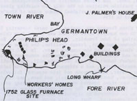
Germantown, the name that replaced Sheds Neck for the peninsula, was given to it by developers of one of earliest planned industrial colonies in the country. They had hoped to profit from both recruiting needed immigrants and exploiting their skills. In 1750, Massachusetts state officials approved a scheme promoting immigration that offered land and money to agents who could bring settlers to the colony. The settlers had to be Protestants, and they would have to live in new settlements in the northern and western part of the colony. Skilled labor was needed, and it was thought the immigrants could act as a buffer in the frontier against the French and Native Americans. A Boston group was formed lead by German-born Joseph Crellius (?-1765). It included prominent citizens, John Franklin (1690–1756), Benjamin Franklin’s older brother, Norton Quincy (1716–1801) of the Quincy political family, and whose father was then owner of Sheds Neck, and Joshua Winslow (1694-1769), his brother Isaac Winslow (1709-1777) was a successful Boston merchant who as a loyalist would later flee to Nova Scotia. Protestant Germans, known as Palatines from the region they were from, had been emigrating to England and then the New York region since the early 1700s. The first efforts to recruit these Germans for Massachusetts did not results in enough people to fulfill the requirements for the new frontier settlements. Prominent local Quincy citizens Richard Cranch (1726-1811), and his brother-in-law, Joseph Palmer (1716-1788) purchased the rights to the immigration scheme after this and focused on having the German immigrants live in housing they had built and run the glass factory on the site. The business failed after three years, and then a second attempt in the 1760s also failed. Many of the Germans moved to New Hampshire and Maine. |
| |
The USGS lists two other capes on Germantown Point, Gull Point (0 ft. Cape) and Philip Head (0 ft. Cape). Gull Point appears on NOAA maps in 1850s and in descriptions of how to navigate into the Fore river. Philip Head in one telling received its name as the spot where the Native American Metacomet feasted and had clam bakes, and where he planted a row of willow trees. Metacomet was also known as King Philip, the protagonist in the war the carries his name. |
| |
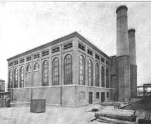
The USGS-listed Shipyard Point (13 ft. Cape) is located at the convergence of the Town and Fore Rivers. The whole area has been a center of shipbuilding since the launching of the ketch Unity in 1696. In 1789, the 116 ft. Massachusetts was launched from the Germantown side. It was the largest mercantile vessel built in North America. The clipper ship red Cloud was built in 1877 at the Thomas Shipyard at Shipyard Point. In 1901, with the opening of the Fore River Shipyard, most major shipbuilding moved up the Fore River. In its place on Shipyard Point, the Old Colony Street Railway Company built a power station to run its electric trains. Next in 1939 Proctor & Gamble built a plant to produced soaps and detergents on the site. That plant was bought by Twin Rivers Technologies in 1994 to make oleochemical products such as fatty acids and glycerin used in the production of laundry detergent and personal care items like toothpaste, soap bars, shower cream, and shampoo. They in turn were bought by Felda Global Ventures in 2007. The Malaysia-based conglomerate is the third largest grower of palm trees for palm oil in the world. |
| |
Just up the Town River from Shipyard Point is the USGS-listed Hole Point (0 ft. Cape). An 1891 U.S. Corps of Engineers report describes a “remarkable formation” in the river, a “Deep Hole”, 1,100 ft. long, 600 ft. wide, and 48 ft. deep at low tide. This in area of the bay when shallow mud fats are typical. The report goes on to say, “a series of similar "pot holes" are found on the shore (Hole Point).” |
| |
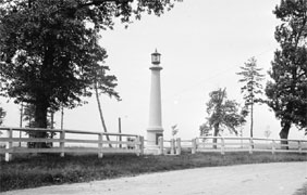
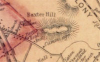
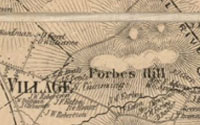
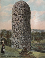
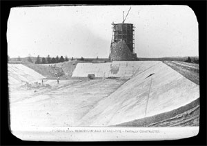
Forbes Hill (167 ft.) is one of two USGS-listed hills in Quincy, not including hills in the Blue Hills Reservation, that carry a family name. The hill is best-known today for a castle-like granite water tower on its summit built by the Boston Metropolitan Water Board between 1899-1902. The hill was purchased by John Murray F. (1813-1898) in 1846. He was the third son of Ralph Bennet Forbes (1773-1824) and Margaret (Perkins) Forbes (1773-1856). Margaret was the sister of the noted, wealthy china merchant (also slave trader and opium smuggler) Thomas H. Perkins (1764-1854), and when Ralph B. Forbes died young, their uncle Thomas Perkins brought the three boys into the business. The youngest of the brothers, Thomas T. Forbes (1802-1829), would die in typhoon off the coast of China. The second son, Robert B. Forbes (1804-1889), would also become a major China merchant and ship owner. John M. Forbes would start in the China trade but instead would become a major investor in American railroads in the Midwest. Ownership of the hill would pass to John’s son, William H. Forbes (1840-1897), an early investor in the Bell Telephone Company and later its president. The final Forbes family owner of Forbes Hill before it was over by the state was William’s son, W. Cameron Forbes (1870-1959), he started out in the investment firm his father founded, but also served as a diplomat in the Philippines and then Japan. |
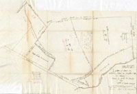
| |
A hand-drawn map of the Forbes Hill area by a surveyor in 1872 is titled, “A plan of lands on Wilcocks, Shaws or Baxters Hill in Quincy owned by John M. Forbes 1846.” The Baxter’s are one of the founding families of Quincy. Gregory Baxter (1606-1659) immigrated to the New England possibly as early as 1630, first living in Roxbury, then moving to what was then Braintree in 1640. The name Baxter Hill appears on an 1853 Henry F. Walling map of Norfolk County. And in John G. Hales 1819 Map of Boston and its Vicinity, there is a house marked Baxter next to the otherwise unnamed hill. There is little information on anyone named Wilcox in the area, but there is a similar name used to identify a hill in Albert K. Teele’s 1887 book, The History of Milton, Mass. In a section about the boundaries of Milton, he says one the boundaries are, “a straight line drawn from near the north-east base of Woodcock Hill (now Forbes Hill) to the top of Great Blue Hill, separating the town from Braintree.” The time frame in 1660s. A connection to the name Shaw for the hill is more obscure. Members of the Shaw family were early settlers in Weymouth, but not Quincy. There was an Abraham Shaw (c.1585-1638) who immigrated as early as 1635 living first in Watertown, then Dedham. He died not long after. His sons and daughters, Abraham’s wife also died in 1638, sold the land in Dedham and moved and settled in Weymouth. Another name for Forbes Hill was Third Hill. There was a local newspaper in early 1900s called the, “Third Hill Searchlight”, and postcards of era call it, Wollaston’s Third Hill. The nearby Broads Meadows Marsh used to be called Three Hill Marsh, but that for three hummocks in the area. Edmund H. Garrett in his 1900 book, The Pilgrim Shore, likely provides the origin on the name. In a chapter on Quincy, he describes a plaque in front of the Wollaston Unitarian Church, “at the foot of First Hill.” Then later, “Grand View Avenue, shady and pleasant, leads on to Second Hill.” Oddly, Garrett doesn’t mention Third Hill. |
| |
The other hill with a family name is Penns Hill (200 ft.). James Penniman’s (c.1600-1664) name is first in the 1640 document that created the town of Braintree. He, his wife Lydia (Eliot) Penniman and children, had likely arrived in 1631 first living in Charlestown, then Boston. By 1637 the Pennimans were living in what was then called Mount Wollaston. The move was most likely in response to James getting caught up in the Antinomian Controversy. The religious and political conflict was triggered by conflicting interpretations of clerical doctrine, and it resulted in the banishment from the Massachusetts colony of the most fervent supporters. Many of these people would become founders of the colony of Rhode Island. James wasn’t banished, but he was accused of signing a document supporting the Antinomians, and for that he was disarmed, meaning he had to turn in any weapons and could no longer vote in town affairs. In an unusual defense, James said he never signed the petition. For less fervent believers, moving to nearby Mount Wollaston was an acceptable alternative. James and Lydia would have nine children, most of whom survived childhood. In 1720, one of their grandsons would sell his house to John Adams, second president of the United States. Also of note, Lydia’s brother was John Eliot (1604-1690). He was known as the “Apostle to the Indians,” for his role in converting Native Americans to Christianity. |
| |
Penns Hill had an earlier name, Paynes Hill. What is unusual is that it was consistently labelled Paynes Hill on maps up until 1900, then it switched. Moses Payne (1581-1643) arrived in Braintree not long after Penniman, and owned land in the same area. He was a widower when he arrived, and in a coincidence, he married Judith (Pares) Quincy (1606-1654), the widow of Edmund Quincy (1602–1636), the progenitor of the Quincy family in New England. They didn’t have any children together, but it was Edmund’s grandson John Quincy (1689-1767), who the town would be named after, and John’s granddaughter Abigail Smith (1744-1818) would marry John Adams. |
| |
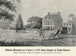
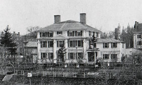
USGS-listed Presidents Hill (131 ft.) is on land that came with a house John Adams bought in 1787, two years before he became George Washington’s vice president. The house had been built by Leonard Vassall (1678-1737) in 1731 as a country residence. Leonard was the grandson of William Vassall (1592-1656). Both William and his brother Samuel were original investors in the Massachusetts Bay Company. William was on a ship in John Winthrop’s fleet in 1630. Samuel’s fleet of ships would regularly supply the colonists. William and Samuel were two sons John Vassall (1544-1625). He was a French Huguenots who had escaped to England before the purges of protestants in France. Once there, he outfitted two ships at his own expense to fight against the Spanish Armada, earning a grant of arms from the Queen. The name Vassall seldom appears in the written history of early New England. He was an important figure at the time, but history typically is written by the victor, and what is recorded are the criticisms of Vassall by Puritan leader John Winthrop and Pilgrim leader Edward Winslow. They thought he was a, “busy, factious spirit, and always opposed to Civil Government of the country and the of the churches here.” Why did they “utterly abhor” him? Because of Vassall’s idea of religious tolerance. He is quoted believing that the colony should, “allow and maintain full and free tolerance of religion to all men that would preserve the civil peace, and submit unto Government, and there was no limitation or exceptions against Turk, Jew, Papist, Arian, Socinian, Nicholaytan, Familist, or any other.” A concept that would have shocked religious and political leaders of the time. Puritans and Pilgrims had left England looking for religious freedom, but what they really wanted was the freedom to live in a place where all citizens would practice the religion they chose. Vassall was a religious man, and would settle with his family in Scituate, halfway between the Pilgrims and the Puritans. There were no Papists in Scituate, but there were Episcopalians. That was problem enough for the Pilgrim church, but the crisis that would lead to Vassall’s departure was the pastor’s insistence on full body immersion for baptisms. Vassall would leave for England, and author a petition demanding that the colonies offer greater religious and political freedom and closer adherence to the laws of England. Nothing would come of it, and he and his family would settle in Barbados. The British capture of Jamaica from the Spanish in 1657 provided the next generation of the Vassal family the opportunity to establish lucrative sugar plantations. |
| |
The grandson of William Vassall, Leonard Vassall (1678-1737), would return to New England, and this time, while not being ignored by history, would head a family that would be disparaged by history for their loyalty to England. There is a Vassall connection to almost every house on Tory Row in Cambridge, Mass. In the early 1720s, Leonard left Jamaica and moved to a changed Boston. The Puritans grip on religion had weakened, though not before authorities had hung a woman in 1660 for being a Quaker. Changes were occurring. In 1665, a Baptist church was organized. In early 1720s a Quaker meeting house was opened. For Catholics, it wouldn’t be until 1788 before a public mass was held in Boston. Arians, Socinians, Nicholaytans, and Familists never became an issue. Unlike in his grandfather’s time, Episcopalians were the mainstream, and Leonard Vassall would be one of founders of Trinity Church purchasing the land where the first building was located. When Leonard died in 1737, he left the summer house in Braintree, with its formal garden and orchard, to his youngest daughter Anna Vassall (1735-1823). She was two years old at the time and would marry her step brother John Borland (1729-1775) in 1749 at age 13. The Borland’s lived in one of the most famous Cambridge Tory houses, the Apthorp House, now part of Harvard, where many of next two generations of Vassalls would attend. Unfortunately for the Vassalls, their wealth and perceived extravagant lifestyle made them targets of the revolutionary-era mobs. Not all of Leonard Vassall’s descendant were loyalists, but the ones that were fled to Boston for protection, and then left the country. The disaster was worse for Anna Vassall Borland when her husband fell off a ladder in 1775 and died. Many loyalists lost all their property and would have to start again. The Vassalls had it easier that most. Their wealth was partially based on sugar plantations in the West Indies, which they still owned. For Anna Vassall Borland, she was able to not lose ownership of house in Braintree. Possibly because the property had been given to her, and as a woman, while her legal rights were not good, the law did view her as neutral in matters of her husband. Or, possibly because her son Leonard V. Borland (1759-c.1801) married Sara Lloyd (1766-1839). Her brother was James Lloyd (1769-1831), he was a Boston merchant, businessman, politician, and would become a U.S. Senator from Massachusetts. |
|
|
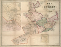
| Quincy Maps |
| • |
Quincy - Google Maps, Terrain |
| • |
Quincy - MassMapper MassGIS |
| • |
Quincy - USGS - The National Map |
| • |
Blue Hills Quadrangle - 2018 (60 MB PDF) - USGS Topo Download |
| • |
Boston South Quadrangle - 2018 (60 MB PDF) - USGS Topo Download |
| • |
Weymouth Quadrangle - 2018 (60 MB PDF) - USGS Topo Download |
| • |
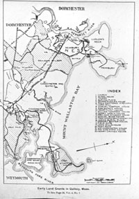
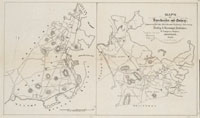
Early Land Grants in Quincy, Mass., Thomas Crane Public Library - Digital Commonwealth |
| • |
Map of Boston and its Vicinity from Actual Survey, John G. Hales, 1819 - Norman B. Leventhal Map Center, Boston Public Library |
| • |
Map of the Town of Quincy, Henry F. Walling, 1857 - Norman B. Leventhal Map Center, Boston Public Library |
| • |
Map of Dorchester and Quincy, Massachusetts, Dudley & Greenbough, 1868 - Norman B. Leventhal Map Center, Boston Public Library |
| • |
Map of Quincy, W. A. Greenough & Co., 1897 - Thomas Crane Public Library, Digital Commonwealth |
| • |
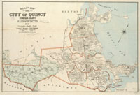
Map of Quincy, Massachusetts, Geo. H. Walker & Co., 1898 - Norman B. Leventhal Map Center, Boston Public Library |
| • |
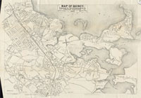
Map of the city of Quincy, Norfolk County, Massachusetts, Ernest W. Branch, Civil Engineer, 1907 - Norman B. Leventhal Map Center, Boston Public Library |
| • |
Atlas of Quincy, Massachusetts, Geo. W. Stadly & Co., 1897 - State Library of Massachusetts |
| • |
Map of Norfolk County, Massachusetts, Henry F. Walling, 1853 - Library of Congress |
| • |
Map of Norfolk County, Massachusetts, Smith & Bumstead, 1858 - Library of Congress |
| • |
Surficial Geology Map of Quincy, Massachusetts, 1964, Donald E. Reed, 1964 - MIT Institute Archives & Special Collections |
| • |
Blue Hills Reservation Trail Map (PDF) - State of Massachusetts |
| • |
Topographical map of Blue Hills Reservation, Massachusetts. Metropolitan Park Commission, 1895 - Norman B. Leventhal Map Center, Boston Public Library |
| • |
Guide to View from Great Blue Hill, Milton, E.G. Chamberlain, 1904 - Collection of Historical Scientific Instruments, Harvard University |
| • |
Blue Hills Reservation, Massachusetts. Metropolitan Park Commission, 1905 - Norman B. Leventhal Map Center, Boston Public Library |
| • |
Blue Hills Reservation; Massachusetts, E.G. Chamberlain,1885 - Olmstead Archives, NHS, NPS |
| • |
About the Blue Hills - Friends of the Blue Hills |
| • |
Surficial Geology Map of Quincy, Massachusetts: 1964 - Massachusetts Institute of Technology |
|
|
| Quincy Sources |
| • |
Some Account of the Early History and Present State of the Town of Quincy in the Commonwealth of Massachusetts, George Whitney, 1827 - Internet Archive |
| • |
A History of old Braintree and Quincy, with a Sketch of Randolph and Holbrook, William F. Pattee, 1878 - Internet Archive |
| • |
Records of the Town of Braintree, 1640-1793, Samuel A. Bates, 1886 - HathiTrust |
| • |
Quincy, King's Handbook of Boston Harbor, pg. 93, M.F. Sweester, 1889 - HathiTrust |
| • |
History of Braintree, Massachusetts, the north precinct of Braintree, and the town of Quincy, Charles F. Adams, 1891 - Internet Archive |
| • |
Quincy, A City of Progress, William T. Atwood, New England Magazine, pg. 163, 1910 - Google ebook |
| • |
Quincy's Waterfront, Frank F. Crane, New England Magazine, pg. 171, 1910 - Google ebook |
| • |
Three hundred years of Quincy, 1625-1925, Historical Retrospect of Mount Wollaston, Braintree, and Quincy, Daniel M. Wilson, 1926 - HathiTrust |
| • |
Quincy, Massachusetts, Historical Information with Route Map, Quincy Historical Society, 1921 - Internet Archive |
| • |
Quincy, Old Braintree, and Merry-Mount, Daniel M. Wilson, 1906 - Internet Archive |
| • |
Quincy, History of Norfolk County, Massachusetts, with Biographical Sketches of Many of its Pioneers and Prominent Men, Duane Hurd, 1884 - Internet Archive |
| • |
Quincy, History of Norfolk County, Massachusetts, 1622-1918, Louis A. Cook, Vol. 1, 1918 - Internet Archive |
| • |
Quincy Historical Society Newsletters - Thomas Crane Public Library |
| • |
The New English Canaan of Thomas Morton with Introductory Matter and Notes, Thomas Morton (1637), Charles F. Adams (1883) - Project Gutenberg |
| • |
Quincy: Postcard History Series, William J. and Elaine A. Pepe, 2008 - Google ebook preveiw |
| • |
Quincy: A Past Carved in Stone, Patricia H. Browne, 1996 - Google ebook preveiw |
| • |
Quincy Through Time, John Galluzzo, Donald Cann, 2013 - Google ebook preveiw |
| • |
Quincy, MHC Reconnaissance Survey Town Report (PDF), 1981 - Massachusetts Historical Commission |
| • |
History of the Town of Canton, Norfolk County, Mass., Daniel T.V. Huntoon, 1893 - Internet Archive |
| • |
The Blue Hills, Walks and rides in the country round about Boston, pg. 333, Edwin M. Bacon, 1897 - Internet Archive |
| • |
The Blue Hills, E.G. Chamberlain, Appalachian Mountain Club, Appalachia, Vol. 3, pg. 122, 1882 - HathiTrust |
| • |
Researched Meaning of Some Local Native American Names: Squantum, Moswetusett, Mattachuset, Massachusetts, Neponset, Chickataubut (PDF), Quincy History, George R. Horner, 1989 - Thomas Crane Public Library |
|
|
| |
|
| 1 |
Squanto's Story, Three Episodes of Massachusetts History, Vol. 1, pg 23, Charles F. Adams, 1896 - Google ebook |
|
Notes of 17th Century Massachusetts, Maypole Links , Errol Lincoln Uys - Imaging Boston |
|
Native Americans of Southeaster New England in the Contact Period, Boston Harbor Navigation Improvement Project, U.S. Army Corps of Engineers, 2008 - Google ebook |
|
The Converging Cultures of the Neponset River Estuary, Richard Heath - Dorchester Antheneum |
| 2 |
The Miles Standish Monument - Google ebook |
|
The Argonauts of Boston Bay, Three Episodes of Massachusetts History, Vol. 1, pg 13, Charles F. Adams, 1896 - Google ebook |
|
A Relation of our Voyage to the Massachusetts and what happened there, Mourt's Relation, pg. 124/57, Edward Winslow, 1622 - HathiTrust |
|
Pilgrims and Puritans: The Story of the Planting of Plymouth and Boston, pg. 171, Nina Moore, 1888 - Google ebook |
|
Their Miliary Expeduitions, Captain Myles Standish on, pg. 127, Tudor Jenks, 1905 - Google ebook |
|
The Indians, Miles Standish: The Puritan Captain, pg. 117, John S. C. Abbott, 1875 - Google ebook |
|
The Archaeology of Thompson Island (PDF), Barbara E. Leedtke, Dept. of Anthropology, 1996 - ScholarWorks, University of Massachusetts Boston |
|
History of Plymouth Plantation, pg. 104, William Bradford, 1626 - HathiTrust |
| 3 |
The Converging Cultures of the Neponset River Estuary, Richard Heath, 1996 - Dorchester Atheneum |
| 4 |
A Relation of our Voyage to the Massachusetts and what happened there, Mourt's Relation, pg. 124/57, Edward Winslow, 1622 - HathiTrust |
| 5 |
Wollaston and Morton (PDF), H. Hobart Holly, Quincy History Society Newsletters, 1995 - Thomas Crane Public Library |
|
|