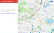
| Hills of Belmont, Mass. |
| | Hills | More about Belmont's USGS-listed hills | Maps | Sources | |
| Clark Hill |
|
| Lone Tree Hill |
|
| Orchard Hill |
|
| Pequossette Hill |
| • |
Google Maps | Google Earth - Google |
| • |
"..There was a way leading to it, sometimes called Pequusset Road, and likewise a Pequusset Hill. The extent of the meadow, which bore this name, has not been ascertained...", Bond, pg, 694 - Internet Archive |
| • |
"...Continuing upon Common Street we may come again to the Payson Park; but Washington Street -- one of the oldest streets in the town --” anciently called Hill Street, from Pequossette Hill, near whose summit it passes, turns here to the east...", Hurd, pg, 694 - Internet Archive |
| • |
Payson Park -"...the Payson Park subdivision which occupies land that was originally part of J.P. Cushing’s estate, 'Bellmont'. After Cushing’s death in 1862, the estate was purchased by Samuel Payson who sold the property to the Payson Park Land Company in 1886..."
"The City of Cambridge's distribution reservoir, though no longer
technically part of Belmont, is completely surrounded by Payson Park." - Massachusetts Cultural Resource Information System (MACRIS) |
| • |
...Another family bought Bellmont, Samuel R. Payson, owner of a woollen mill, lived there happily for twenty years, unit his business failed...", pg, 65 - Brief Dynasty, John Perkins Cushing's Bellmont, So Fine a Prospect: Historic New England Gardens, Alan Emmet, 1996 - Google ebook |
| • |
"..At the very foot of Pequossette Hill is the Hitlinger residence, where Jacob Hittinger lived at the time when, for five successive years, he headed the list of those who sought for recognition as an independent town...", Hurd, pg, 694 - Internet Archive |
| • |
"...a winding walk among the trees led to a rustic summer-house upon the highland anciently called Pequossette Hill, from which a varied and extended view of Boston and its suburbs wiw revealed to the observer...", Hurd, pg, 691 - Internet Archive |
| • |
"..It merits its same, which was derived from the residence of John P. Cushing, later known as the Payson estate, upon the street separating Belmont from Watertown...", Hurd, pg, 691 - Internet Archive |
| • |
"Not all of the historic resources in Payson Park are residential. The Payson Park Reservoir was constructed by the City of Cambridge on Pequossette Hill between 1894 and 1897. The 163-acre parcel is owned by the City of Cambridge and the reservoir holds 43 million gallons of drinkable water..." (PDF), pg, 40 - Payson park, Town of Belmont |
| • |
"...William Shattuck, s. of William, was b. in Watertown in 1653. He lived in the easterly parish upon the old
homestead on Common Hill, "on the highway to the pond," where he died Oct. 19, 1732, aged 79...." Lemuel Shattuck, 1855, pg. 74 - Memorials of the Descendants of William Shattuck - Internet Archive |
|
| Snake Hill |
| • |
Google Maps | Google Earth - Google |
| • |
"...The May 31, 1940, edition of the Belmont Citizen explains the origins of Koch’s development as follows: “Two Harvard instructors and three graduates have purchased ‘Snake Hill’ as a joint venture for a planned community.” The group changed the name of the street from Witsend Road to Snake Hill Road in honor of the many snakes that once inhabited the hillside...." (PDF), 2005, pg, 4 - Belmont Citizen Forum |
| • |
Snake Hill Road -"...Carl Koch, architect and designer of the project, selected the Snake Hill location in Belmont because it 'has a magnificent view of Boston, is within one-quarter mile of transportation and stores and was for sale cheap because its rocky ledges were not believed suitable for conventional houses.'..." - Massachusetts Cultural Resource Information System (MACRIS) |
|
| Walnut Hill |
|
| Wellington Hill |
| • |
USGS identified - MassMapper MassGIS |
| • |
Google Maps | Google Earth - Google |
| • |
"...Town occupies approximately 4.6 square miles. The northern half of the town is occupied by Wellington, or Belmont Hill, the southward face of which marks the beginning of the Fells Upland district..." - Belmont, MHC Reconnaissance Survey Town Report (PDF), 1980 - Massachusetts Historical Commission |
| • |
"..In recent times it obtained the name of Wellington Hill, from this circumstance: At the bottom of this hill lived, in the last century, Colonel Jeduthan Wellington, a somewhat prominent citizen, who was first and foremost in procuring a
chartered turnpike road from Harvard Square in Cambridge to Concord, through this valley, thus making a little shorter route to Boston than the old roads through Waltham and Watertown, or Lexington and Arlington....", Drake, pg, 251 - Internet Archive |
| • |
"...Roger Wellington, the founder of his family in America, was born in England about 1609. He came to tins country in 1630, and in 1636 bought fourteen acres pf land on the border of Watertown and Cambridge, now called Belmont..." (PDF), pg, 7 - A few Facts Concerning Roger Wellington and Some of his Descendants, A.W. Grisworld, 1892 - Ex Libris Rosetta |
| • |
Wellington Hill - USGS Geographic Names Information System |
|
|
|
|
|
| More about Belmont's USGS-listed hills |
|
Unlike many of other towns and cities in the Boston Basin, Belmont is not simply a section of a larger entity. For example Wakefield, it was initially part of Lynn, then it was part of Reading, before eventually splitting off and become its own town. Though, Belmont does have something in common with Wakefield. |
| In 1854 a group of citizens applied to create a town that included parts of Watertown, West Cambridge (Arlington) and Waltham. The affected communities resisted giving up the land, and the struggle continued until 1859 when approval was finally given.1 During the drawn-out process, one of the most enthusiastic advocates, and biggest financial supporters, was John Perkins Cushing (1787-1862).2 |
| The Cushing’s and the Perkins’ were elite Boston Brahmin families, and John, in 1830, had recently returned after 30 years running a successful trading house in Canton, China. His uncle, Thomas Handasyd Perkins (1764-1854) had been one of the first Boston merchants to begin trading in China. John had skillfully expanded the business eventually focusing on the opium trade. Upon his return, John built a mansion on Sumner Street in Boston, and another in what was then Watertown. While Cyrus Wakefield was a major supporter of town that was named after him, the condition John Perkins Cushing set for his financial support was that it be named after his country estate, Bellmont. The second “l” was dropped.3 |
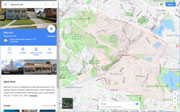
| Belmont has one USGS listed hill, Wellington Hill (295 ft.). The Wellingtons in the area date back to Roger Wellington (1609-1698) when, in 1636, when he bought land on the border or Watertown and Cambridge, now Belmont.4 The Wellington associates with the hill in Belmont was Jeduthan Wellington (1750-1838). In 1803, he headed a corporation that was given the authority to build and charge tolls on a turnpike from Cambridge to Concord.5 The portion on Concord Turnpike path Jeduthan laid out lead directly to his home and tavern at the base of the escarpment that separates the relative flats of Cambridge to hills of Concord. It became a popular stagecoach layover stop and Jeduthan provided extra oxen to help climb the steep grade. The hill became known as Wellington Hill.6 |
| In Belmont the Wellington name has been fixed to, an elementary school, former high school, railroad station, subdivision, brook, park, homestead, historic marker, and lane. Wellington naming fatigue appeared to have set in when Lone Tree Hill was chosen for the name of a new public open space on the McLean Hospital land in 2011. Local open-space advocate Judith Record suggested the name after seeing a single tree in the middle of a meadow.7 |
|
|
| Belmont Maps |
| • |
Belmont - Google Maps, Terrain |
| • |
Belmont - MassMapper MassGIS |
| • |
Belmont - Mapjunction |
| • |
Lexington Quadrangle - 2018 (60 MB PDF) - USGS TopoView Download | All USGS maps |
| • |
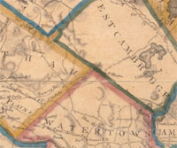
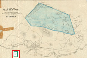
Map of Watertown/Belmont 1830 - Digital Commonwealth |
| • |
Map of Watertown/Belmont 1850 - Digital Commonwealth |
| • |
Map of Watertown/Belmont 1853 - Digital Commonwealth |
| • |
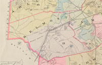
Belmont maps 19, 21, Atlas of Middlesex County, Volume 1, Geo. W. Stadly & Co., 1900 - State Library of Massachusetts |
| • |
Belmont, Atlas of Middlesex County, Volume 2, Geo. H. Walker & Co., 1906 - State Library of Massachusetts |
|
|
| Belmont Sources |
| • |
Belmont, History of Middlesex County, Massachusetts, with Biographical Sketches of Many of its Pioneers and Prominent Men, Duane Hurd, 1890 - Internet Archive |
| • |
Belmont, History of Middlesex County, Massachusetts: Containing Carefully Prepared Histories of Every City and Town in the County, Samuel A. Drake, 1880 - Internet Archive |
| • |
Historical Sketches of Watertown, Massachusetts, Solon F. Whitney, 1893 - Internet Archive |
| • |
Genealogies of the Families and Descendants of the Early Settlers of Watertown, Massachusetts, including Waltham and Weston, Henry Bond, 1860 - Internet Archive |
| • |
Then & Now - Belmont, Belmont Historical Society, 2004 - Google ebook preview |
| • |
Belmont Historical Society |
| • |
Belmont Historical Society presents: The Streets of Belmont by RIchard B. Betts (Video), 1996, Belmont Historical Society - Internet Archive |
| • |
Belmont, MHC Reconnaissance Survey Town Report (PDF), 1980 - Massachusetts Historical Commission |
|
|
| Footnotes |
| 1 |
Hurd, pg. 683, 1890 - Internet Archive |
| 2 |
History & Facts - Town or Belmomt, Massaschusetts |
| 3 |
John Perkins Cushing - Wikipedia |
| 4 |
The Wellingtons, Cambrdige Tribune, November 15, 1913 - Cambridge Public Library |
| 5 |
The Turnpikes of New England, pg. 119, Frederic J. Wood, 1919 - Belmont Historical Society |
| 6 |
Massachusetts State Highway 2, "The Concord Turnpike" (PDF) - Belmont Historical Society |
| 7 |
McLean Open Space's New Name: Lone Tree Hill, Franklin Tucker, 2011 - Belmont Patch |
|
|