| Hills of Everett, Mass. |
| | Hills | More about Everett's USGS-listed hills | Maps | Sources | |
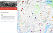
| Belmont Hill |
| • |
Google Maps | Google Earth - Google |
| • |
"...Belmont Hill is one hundred and thirty-three feet above mean low water level. It was first called Sargent's hill in honor of Everett's
earliest settler. Later, it became known as Nelson's Hill after Ebenezer Nelson, a preacher, and then it was called Belmont Hill. The
first meeting house and the first school were situated on this hill. ..", De Giacomo, pg. 33, 1953 - Boston University |
| • |
"...William Sargent, a haberdasher and a preacher, who is described by Edward Johnson as a 'godly Christian,' was upon the pleasant highland in Everett which long bore his name, but which has since been known as Nelson's Hill from a later resident, the Rev. Ebenezer Nelson of the First Baptist Church; and James Barrett, with his house at the present corner of Main and School Streets, has been mentioned.....", Corey, pg. 102, 1899 - Internet Archive |
| • |
"...it seems probable that they began about this time to build a meeting house upon the hill in Everett known at various times as Sargeant's, Nelson's, or Belmont Hill. Here, on a spot near the present easterly corner of High Street and Broadway, Jonathan Sargeant had set apart a piece of land near the centre of the farm which had descended from.....", Corey, pg. 527, 1899 - Internet Archive |
| • |
"... William Sargeant, who soon after sold his farm on the Everett slope of Belmont Hill and moved to Cape Cod, although his
descendants remain among us....", Register of the Malden Historical Society, No. 1-4, pg. 55, 1910-1916 - Hathitrust |
| • |
"...In 1796 a county road was laid out, three rods wide, from Main Street to what is now Everett Square, and then northerly in nearly a straight line over Belmont and Corbett Hills, (now known as the first and second Broadway Hills) through the swamp, then turning easterly to Linden.....", Kyle, pg. 4, 1927 - Internet Archive |
| • |
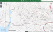
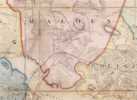
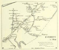
Map of Everett in 1842, Everett Souvenir, 1870-1893, pg. 15, 1893 - Internet Archive |
|
| Corbett Hill |
| • |
Google Maps | Google Earth - Google |
| • |
"...The lowest of the three hills, Corbett Hill, is situated in North Everett. At the crest of Corbett Hill, which overlooks Glendale Park,
is the new Veteran's Housing Project. Glendale Park was once a part of the Corbett Farm. ..", De Giacomo, pg. 33 - Boston University |
| • |
"...Elm Street, which runs between Corbett Hill and Mount Washington to Ferry Street, was an old lane...", De Giacomo, pg. 26, 1953 - Boston University |
| • |
"...This land was for forty years the home of the Mudges, then of the Chittendens. Lastly, it was the farm of Leavitt Corbett, who will be remembered by many. It is now a portion of the Woodlawn Cemetery
Company's lands...", Corey, pg. 70, 1899 - Internet Archive |
| • |
Map of Everett in 1842, Everett Souvenir, 1870-1893, pg. 15, 1893 - Internet Archive |
|
| Mount Washington |
| • |
USGS identified - MassMapper MassGIS |
| • |
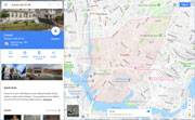
Google Maps | Google Earth - Google |
| • |
"...Mount Washington was once the seat of the great Indian Sachem, leader of all the tribes in the area, Nanapashamet. It was called Sagamore Hill until 1855 when it was given its present name by Caleb Pratt, a carpenter, who owned considerable land there ..", De Giacomo, pg. 33, 1953 - Boston University |
| • |
"...This area was ruled by the last great Indian Sachem, Nanapaehamet who lived in the area of Saugus Marsh. This area. was named Rumney Marsh by the English. He later made hie headquarters on the top of Sagamore Hill which is now a. part of Everett and Chelsea. Sagamore Hill is now called Mount Washington. ..", De Giacomo, pg. 10, 1953 - Boston University |
| • |
"...The hill was variously called Sagamore Hill, and in 1740 Chelsea Hill, and from 1855 Mount Washington in honor of General Washington...", Everett During the American Revolution (PDF) - City of Everett |
| • |
"...Mount Washington in Everett was known as Sagamore Hill; a name one might wish it had never lost, as it implies
that on, or near it, the Indians had one of their seats...", Chamberlain, pg. 71, 1908 - Internet Archive |
| • |
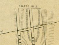
Pratt's Hill, Map of Chelsea, Mass., 1867 - Norman B. Leventhal Map Center, Boston Public Library |
| • |
Mount Washington - USGS Geographic Names Information System |
|
|
|
 |
|
 |
|
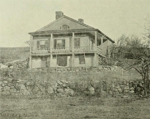
| Belmont Hill |
 |
|
 |
|
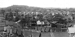
| Corbett Hill |
 |
|
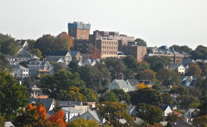
| Mount Washington |
 |
|
 |
|
 |
|
|
|
| More about Everett's USGS-listed hills |
|
Everett, Mass. was originally part of Charlestown, and later Malden. It separated from Malden in 1870 and incorporated as a city in 1892. It was named after Edward Everett, who served as U.S. Representative, U.S. Senator, Governor of Massachusetts, Minister to Great Britain, U.S. Secretary of State, and taught and served as the President of Harvard University. He is also the man who gave the two-hour speech at Gettysburg before Abraham Lincoln’s more famous two-minute speech.1 Considered one of the greatest and most popular American orators of the era, it was Everett who had received most prominent billing at the dedication.2 |
| Everett has one USGS-listed hill, Mount Washington (164 ft.). Part of the hill is in neighboring Chelsea and how it got its name is a result of events in that town. On June 17, 1775 colonial forces lose the Battle of Bunker Hill and British troops occupy and fortify both Breeds and Bunker Hill. Two days earlier, George Washington had been selected as Commander in Chief of the Continental Army. On July 2, 1775 he arrives in Cambridge, Mass. and takes command of the Army the next day. The encirclement strategy he devises has troops stationed on the eastern slope in Chelsea of what was first called Sagamore Hill, then Chelsea Hill. The western slope is in what was then Malden, now Everett. Sometime in July or August of 1775 George Washington was in Chelsea inspecting the troops and is reported to have stayed at the house of Thomas Pratt.4 |
| The Pratts were an important family in Chelsea. The family had immigrated to Malden in 1636. The first Pratts settled in Chelsea, then Winnisimmet, in 1695.3 In the 1850s, Caleb Pratt bought enough land on Sagamore Hill where an 1867 map identifies it as Pratt’s Hill. Caleb lobbied for the creation of a Washington Park to honor Chelsea’s part in the Revolutionary War, and likely help in sales of lots on the hill he owned, and those owned by the Mt. Washington Land Company. It would take his grandson, Hermon Pratt, then the Chelsea mayor, to get the park built in 1887, in the Prattville neighborhood.4 |
| The earlier name for Mount Washington, Sagamore Hill, dates back to a 1641 record for approval to build a county highway, “…to the Powder Horne Hill, & from thence about the west end of said hill, & over the east end of Sagamore Hill... “.5 Sagamore, from the Algonquian language, is a term used to describe the rank of tribal leader or chief.6 There is also a Sagamore Hill in Hull, Lynn, and Quincy. Likely all named by the settlers for places where they would have met with Native Americans, and the Sagamore. |
| Mount Washington is also known as Hospital Hill, named for the Whidden Hospital (now CHA Everett) on its summit. In 1850, Andrew Whidden (born 1822) and his brother Stephen started a shipwrights and caulkers business on the docks of East Boston. With Boston one of leading ports in the country, the shipping and shipbuilding industries were expanding rapidly.”7 Over the next 32 years, the two brothers ran one of the largest wooden ship repair facilities in the country. When Andrew died in 1895, it was said, “No man in the country knew a wooden vessel technically and practically better than Mr. Whidden.”8 In 1897 Georgia, his daughter, donated the estate and old homestead on top of Mount Washington for hospital purposes with the stipulation that it maintains a policy of “open admission of patients without distinction as to creed, color or race.”9 |
|
|
| Everett Maps |
| • |
Everettt - Google Maps, Terrain |
| • |
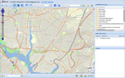
Everett - MassMapper MassGIS |
| • |
Everett - USGS - The National Map |
| • |
Boston North Quadrangle - 2018 (60 MB PDF) - USGS Topo Download |
| • |
Map of Everett in 1842, Everett Souvenir, 1870-1893, pg. 15, 1893 - Internet Archive |
| • |
Everett Maps: 25, 26, 27, 28, Atlas of Middlesex County, Volume 1, George W. Stadly & Co., 1900 - State Library of Massachusetts |
| • |
Map of Middlesex County, Massachusetts, Henry W. Walling, Ferd. Mayer & Co., 1856 - Norman B. Leventhal Map Center, Boston Public |
| • |
Everett, Middlesex County Atlas, F.W. Beers, 1875 - Historic Map Works |
|
|
| Everett Sources |
| • |
An Historial Sketch, Everett Souvenir, 1870-1893, Dudley P. Bailey, 1893 - Internet Archive |
| • |
A Social History of Everett, Massachusetts 1614-1952, John De Giacomo, 1953 - Boston University |
| • |
History of Everett, Massachusetts, Ruth G. Hines, 1932 - Boston University |
| • |
The History of Malden, Massachusetts, 1633-1785, Deloraine P. Corey, 1899 - Internet Archive |
| • |
The Register of the Malden Historical Society, Malden, Massachusetts - Hathitrust |
| • |
The Straight Road, A short account of the Newburyport Turnpike and early days in Everett, Massachusetts, George A. Kyle, 1927 - Internet Archive |
| • |
Everett, History of Middlesex County, Massachusetts, with Biographical Sketches of Many of its Pioneers and Prominent Men, Duane Hurd, 1890, Vol. 3 - Internet Archive |
| • |
Everett, History of Middlesex County, Massachusetts: Containing Carefully Prepared Histories of Every City and Town in the County, Samuel A. Drake, 1880, Vol. 1 - Internet Archive |
| • |
Everett, MHC Reconnaissance Survey Town Report (PDF), 1981 - Massachusetts Historical Commission |
| • |
A Documentary History of Chelsea: including the Boston Precincts of Winnisimmet, Rumney Marsh, and Pullen Point, 1624-1824, Vol. 1, Mellen Chamberlain, 1908 - Internet Archive |
|
|
| Footnotes |
| 1 |
Edward Everett’s “Gettysburg Address” (19 November 1863) - Voices of Democracy |
|
The Other Gettysburg Address, Tedd Widmer, 2013 - New York Times |
| 2 |
Edward Everett Interpretation , 1997 - CSPAN |
| 3 |
Washington Park - Town of Chelsea |
| 4 |
The Chelsea Gazette, Souvenir Edition, pg. 8, Charles B. Gillespie, 1898 - Hathitrust |
| 5 |
The Encyclopedia of North American Indian Wars, 1607–1890, pg. 698, Spencer C. Tucker, 2011 - Google ebook preview |
| 6 |
Records of the governor and company of the Massachusetts bay in New England, Vol. 1. 1628-1641, No. 481, pg. 340, Nathaniel B. Shurtleff, 1853 - Internet Archive |
| 7 |
Stephen Huse Widden House, (PDF), 1991 - Boston Landmark Commission, City of Boston |
| 8 |
The Granite Monthly, Vol. 19, pg. 486, 1895 - HathiTrust |
| 9 |
The Whidden Memorial Hospital Legacy - Cambridge Health Alliance |
|
|