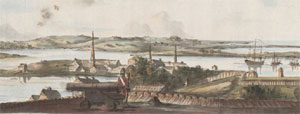
| East Boston today was originally made up of five islands: Noddle's; Hog's (which later known as Breed's Island, and would become Orient Heights); Governor's; Bird; and Apple. |
|
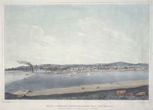
| Hills of East Boston - Boston, Mass. |
| Apple Island |
| • |
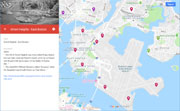
USGS identified - MassMapper MassGIS |
| • |
Google Maps | Google Earth - Google |
| • |
"...Apple Island was a small wooded mound that originally belonged to the City of Boston. It became private property and was sold by Thomas Hutchinson to Estes Hatch in 1723; the Hatch estate sold it to James Mortimer of Boston in 1750....". Moffett, pg. 17 (PDF), 1973 - Massachusetts Institute of Technolog |
| • |
Apple Island (Massachusetts), "...Apple Island was an island in Boston Harbor in Massachusetts, one of five islands that were integrated with landfill over the years to form East Boston and Logan International Airport. Noddle's Island, Hog Island, Bird's Island and Governor's Island were the others...Abandoned for years, Apple Island was reacquired by the City of Boston in 1867 and sold to private citizens. Inhabitants were known to haul wrecked steamships onto the island and burn them for their copper and iron parts...In the 1940s, Apple Island was subsumed into land reclamation for the extension of Boston Airport..." - Wikipedia |
| • |
Apple Island, Snow, pg. 201, 1935 - HathiTrust |
| • |
Apple Island (Island) - USGS Geographic Names Information System |
|
| Bird Island Flats |
|
| Camp Hill |
| • |
USGS location - MassMapper MassGIS |
| • |
Google Maps | Google Earth - Google |
| • |
"...[Noddle Island] was originally about 600 acres composed of several drumlins. Two drumlins were at the southern end of the island - the one on the southeastern promotory came to be know as Camp Hill because of a military encampment there in 1711 during Queen Anne's War and is now Jeffries Point...". Seasholes, pg. 355, 2003 - Google ebook preview |
| • |
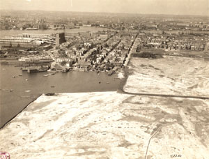
Noddle's Island, "..The original contours of Noddle's Island were also greatly obscured by the 20th-century construction of Logan International Airport, which filled the tidal flats between Noddle's Island and Governor's, Bird, and Apple islands to its east. In some sources it is spelled "Noodle's Island"..." - Wikipedia |
| • |
Camp Hill - USGS Geographic Names Information System |
|
| Eagle Hill |
| • |
Google Maps | Google Earth - Google |
| • |
Eagle Hill Historic District, "..Early maps depict Eagle Hill as the northern drumlin on Noodles Island, one of several inner harbor islands subsumed into East Boston's land mass...This gentle hill, home to shipbuilders, carpenters, and merchants, is associated with East Boston's 19th-century maritime economy and culture..." - Wikipedia |
|
| East Wood Island |
|
| Governors Island |
| • |
USGS identified - MassMapper MassGIS |
| • |
Google Maps | Google Earth - Google |
| • |
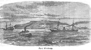
"...Governor's Island was granted by the colonists to John Winthrop on
3 April 1632...The Winthrop family retained possession of the island until 1808,
when it was bought by the U.S. Government as the site for Fort Warren. That name was later transferred to the fort on George's Island...", Moffett, pg. 16 (PDF), 1973 - Massachusetts Institute of Technology |
| • |
Fort Winthrop, "..The fort was renamed Fort Winthrop in 1833 because a larger Fort Warren was being being built further out in the harbor..." - Wikipedia |
| • |
Governors Island (now part of Logan Airport), "..Governor's Island was taken down in the 1920s to create Logan Airport. It was a high green island, conspicuous in all views of the upper harbor..." - Friends of the Boston Harbor Islands |
| • |
Governors Island (Massachusetts), "..Governor's Island was the site of Fort Winthrop, a defensive fortification named after Governor John Winthrop, whose family was granted the island in 1632 and owned it until 1808, when it was acquired for the construction of the fort..." - Wikipedia |
| • |
Governor's Island, Snow, pg. 185 , 1935 - HathiTrust |
| • |
Governors Island (Cape) - USGS Geographic Names Information System |
|
| Orient Heights |
| • |
USGS identified - MassMapper MassGIS |
| • |
Google Maps | Google Earth - Google |
| • |
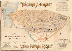
"...The island [Sir William} Brereton called "Susanna" (after his daughter) was locally known as Hog Island. Joseph Russell, who owned it in the late 1700's, renamed it Belle Isle, and that designation continues as the name of the inlet running between the island, Winthrop and Revere. John Breed of Charlestown purchased the island after Russell's death and
lived there "in a large one-story stone house of great length, built by himself." It remained in the Breed family for some time, thus coming to be known as Breed's Island. The chief feature of the island is a 150 foot hill, or drumlin...". Moffett, pg. 16 (PDF), 1973 - Massachusetts Institute of Technology |
| • |
Orient Heights, "..The hill of Orient Heights was once called Hog's Island, but was later renamed Breed's Island, not to be confused with Breed's Hill, the location of the Battle of Bunker Hill. The hill was one of the five islands that comprised East Boston prior to its annexation by Boston in 1836..." - Wikipedia |
| • |
"...Orient Heights...named in recognition of the China Trade with the Orient during the nineteenth century...". Sammarco, 1997 - Google ebook preview |
| • |
Hog or Susanna Island, Snow, pg. 248 , 1935 - HathiTrust |
| • |
Orient Heights - USGS Geographic Names Information System
Variant name: Breeds Island |
|
| Shays Hill |
| • |
Google Maps | Google Earth - Google |
| • |
"...Shay's Hill. Superintendent of streets McDonald reported the cost of cutting down and grading Shay's Hill on Saratoga street, ward 1, to be $8,125, exclusive of grade damages...", Boston Globe, pg. 2. Jan. 22, 1889 - Boston Globe (Subscription) |
| • |
"...that the superintendent of streets proceed at once to remove Shea's Hill and grade the Bennington Street extension at east Boston... ", Boston Globe, pg.2. Jul. 2, 1889 - Boston Globe (Subscription) |
| • |
"...Originally East Boston consisted of two islands, which have been united by filling in for streets and railroads. Breed's Island contains one small hill, Shay's Hill, and one large hill, Orient Heights...", East Boston, A Survey and Comprehensive Plan, , Boston City Planning Board, pg. 60, 1915 - Internet Archive |
| • |
"...The Bayswater area, known as Shay's Hill, was sold as one piece early in 1912 to a developer who subsequently laid out the streets...". Moffett, pg. 63 (PDF), 1973 - Massachusetts Institute of Technology |
|
| Smith Hill |
| • |
Google Maps | Google Earth - Google |
| • |
"...Noddle Island...Two drumlins were at the southern end of the island...and the other was Smith Hill, now leveled to form Maverick Square...". Seasholes, pg. 355, 2003 - Google ebook preview |
| • |
"...Smith's Hill was cut level to fill the marsh area between it and Camp Hill...". Moffett, pg. 24 (PDF), 1973 - Massachusetts Institute of Technology |
|
| West Wood Island |
|
|
|
 |
|
 |
|
 |
|
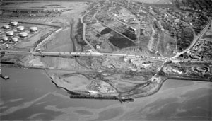
| Apple Island |
 |
|
| Camp Hill |
 |
|
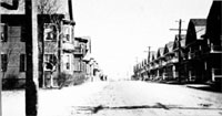
| Eagle Hill |
 |
|
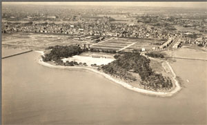
| Governors Island |
 |
|
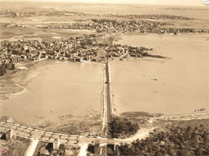
| Orient Heights |
 |
|
 |
|
| Shays Hill |
 |
|
| Wood Island |
 |
|
 |
|
|
| East Boston Maps |
| • |
East Boston - Google Maps, Terrain |
| • |
East Boston - MassMapper MassGIS |
| • |
East Boston - USGS - The National Map |
| • |
Hull Quadrangle - 2018 (60 MB PDF) - USGS Topo Download |
| • |
Boston North Quadrangle - 2018 (60 MB PDF) - USGS Topo Download |
| • |
Boston South Quadrangle - 2018 (60 MB PDF) - USGS Topo Download |
| • |
USGS Historical Topographic Map Explorer |
| • |
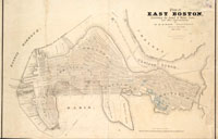
Atlas of East Boston, G.W. Bromley & Co., 1892 - State Library of Massachusetts |
| • |
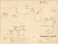
A Plan of a Survey of Noddles Island, William Taylor, 1891 - Norman B. Leventhal Map Center, Boston Public Library |
| • |
Atlas of Charlestown and East Boston, G.W. Bromley & Co., 1922 - State Library of Massachusetts |
| • |
Plan of East Boston Showing the Land and Water Lots Sold and Unsold, Robert H. Eddy, 1837 - Norman B. Leventhal Map Center, Boston Public Library |
| • |
West Wood Island Park, East Boston district, Boston Park Commissioners, 1876 - Norman B. Leventhal Map Center, Boston Public Library |
| • |
A Plan of a Survey of Noddle's Island (Taken for David Greenough by William Taylor, 1801), The Physical Development of East Boston, pg. 20 (PDF), Marian S. Moffett, 1973 - Massachusetts Institute of Technology |
| • |
East Boston Original Islands, The Physical Development of East Boston, pg. 10 (PDF), Marian S. Moffett, 1973 - Massachusetts Institute of Technology |
| • |
A New & Complete Map of the City of Boston with Part of Charlestown, Cambridge and Roxbury George W. Boynton, Nathaniel Dearborn, 1846 - Salem State University Library |
| • |
Plan or Orient Heights, Boston Mass., H. T. Whitman, 1894 - Norman B. Leventhal Map Center, Boston Public Library |
|
|
| East Boston Sources |
| • |
History of East Boston with Biographical Sketches of its Early Proprietors, William H. Sumner, 1858 - Internet Archive |
| • |
Gaining Ground: A History of Landmaking in Boston, Nancy S. Seasholes, 2003 - Google ebook perview |
| • |
East Boston: Exploring Boston's Neighborhoods (PDF), Boston Landmarks Commission, 1994 - City of Boston |
| • |
The Islands of Boston Harbor, Edward R. Snow, 1935 - HathiTrust |
| • |
The Physical Development of East Boston (PDF), Marian S. Moffett, 1973 - Massachusetts Institute of Technology |
| • |
East Boston, Boston 200 Neighborhood History Series, 1976 - Internet Archive |
| • |
East Boston: Images of America, Anthony M. Sammarco, 1997 - Google ebook perview |
| • |
Historic Eagle Hill |
| • |
East Boston Museum |
|
|
|