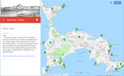
| Hills of Nahant, Mass. |
| | Hills | More about Nahant's USGS-listed hills | Maps | Sources | |
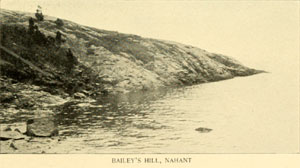
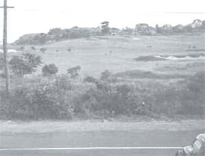
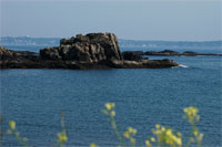
| Baileys Hill |
| • |
USGS identified - MassMapper MassGIS |
| • |
Google Maps | Google Earth - Google |
| • |
"...On the southwest, Bayley's Hill rises one hundred feet above the sea...", Lewis, pg. 479, 1829 - Internet Archive |
| • |
"...At the southeast this rises into a bold promontory about 100 feet in height, called Bailey's, or, later, Nahant Hill...", Nason, pg. 479, 1890 - Internet Archive |
| • |
Battery Gardner #2 - Bailey's Hill North Battery, "...The North Battery on Bailey Hill is one of four concrete batteries that were built into earthworks in Nahant in the 1920s and utilized through World War II...." - Massachusetts Historical Commission Information System (MACRIS) |
| • |
"...Easterly from this is Lewis Beach, and other coves and cliffs break the shore line to Bailey's Hill. This hill, a real hill, projects its entire bulk into the water, and is surrounded by cliffs and ledges against which
great seas lash out in fury when tossed shoreward by storm and
gale.....", Wison, pg. 201, 1928 - Hathitrust |
| • |
"...Many of these old place names seem to have an origin past discovery. A search in vain has been made for Joseph's Beach and Bailey's Hill, for example, yet some one reading these lines may know all about it and wonder at the ignorance of others...", Wison, pg. 202, 1928 - Hathitrust |
| • |
Fort Ruckman, "...A Nike target tracking radar was also erected on Bayley's Hill (the eastern edge of the fort) during the 1950s....." - Wikipedia |
| • |
Baileys Hill - USGS Geographic Names Information System
Variant name: Bayleys Hill |
|
| Bass Beach Hill |
| • |
Google Maps | Google Earth - Google |
| • |
"...A flagstaff was raised on Bass Beach Hill, and when the Stars and Stripes were first hoisted on it, old Captain Henry Dunham, a veteran of the Mexican War, fired the cannon that assisted in the ceremonies.....", Wison, pg 103, 1928 - Hathitrust |
| • |
"...The Abner Hood house, up Bass Beach Hill, was later owned and occupied by a summer resident, John C. Gray, who sold it and built what was commonly known as the Blanchard
house in the early 50's......", Wison, pg 277, 1928 - Hathitrust |
|
| Bass Point |
|
| Bass Rock |
|
| Black Mine |
| • |
Google Maps | Google Earth - Google |
| • |
"...then Black Mine, the latter near the northeast end of Summer Street. These are the black rocks sometimes called the "Iron Mine," which seem to have attracted the attention of the Saugus Iron Works, way back in colonial days....", Wison, pg 198, 1928 - Hathitrust |
| • |
"...In 1691 iron ore, called rock mine, was taken from the ledge at Nahant for the forge at Braintree...Although the quality of the ore smelted in these furnaces may have been good,
there was not sufficient iron in the rock to make it profitable. The town records give no further account of the iron mine at Nabant...",Hurd, pg. 1438, 1888 - Internet Archive |
| • |
Black Mine (Bar) - USGS Geographic Names Information System
Variant name: Iron Mine |
|
| Black Rock Point |
|
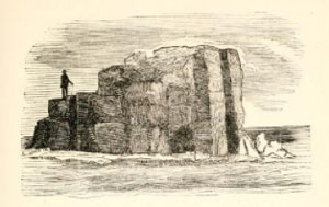
| Castle Rock |
| • |
USGS identified - MassMapper MassGIS |
| • |
Google Maps | Google Earth - Google |
| • |
"...The next beach is Bass Beach, and the two are separated by Castle Rock, a projecting point which allows a half acre or more of land between the road and the sea...", Wison, pg 197, 1928 - Hathitrust |
| • |
Castle Rock (Island) - USGS Geographic Names Information System
Variant names: Castle Peak, Cedar Point |
|
| Colby Hill |
| • |
Google Maps | Google Earth - Google |
| • |
"...The Bass Point amusement district is one of the most beautiful parts of the town. Bass Point itself and all the adjacent shores, and Colby Hill, with its wonderful outlook,
were jammed with cottages, mostly small, and many of them so flimsily built that they were practically summer camps. In fact, forty years ago or so a large section of this district was a tent colony, and from tents came shanties, from shanties, camps, and from camps some cottages of good appearance. Colby Hill was mostly owned by Miss L. Hortense Colby,
a daughter of Alonzo Colby, an old Nahanter....", Wison, pg 22, 1928 - Hathitrust |
| • |
"...Considered part of Fort Ruckman, Site 1A, Harris estate, was on top of Colby Hill, directly to the rear of Battery Gardner. Six stories high, the rectangular, reinforced-concrete tower was formally transferred to the artillery May 29, 1943...", Nahant Harbor Review, June 2009, pg. 18 (PDF) - Nahant Online |
|
| East Cliff |
|
| East Point |
| • |
USGS identified - MassMapper MassGIS |
| • |
Google Maps | Google Earth - Google |
| • |
"...Henry Cabot Lodge, Jr. Memorial Park is located at East Point and has a long, rich history. Originally the site of the Nahant Hotel, it then became the home estate of Henry Cabot Lodge, Jr. This was then followed by the site being converted to the Nike Military Base with missile silos. The Town then established the area as the Henry Cabot Lodge, Jr. Memorial Park in 1986 after it was decommissioned...", Nahant Open Space & Recreation Plan, 2016 - Town of Nahant |
| • |
"...John Ellerton Lodge was one of the best-known ship-merchants of Boston, engaging in commerce chiefly with China...",Other Merchants and Sea Captains of Old Boston, pg. 39, 1919 - Google ebook |
| • |
"...John Ellerton Lodge...In 1850 Mr. Lodge bought some land adjoining Mr. Cabot's house, where he lived, and amused, himself by cultivating and improving it...In I861 the hotel at Nahant on East Point was destroyed by fire, and the property was thrown upon the market. Mr. Lodge...immediately bought the hotel estate for the mortgages then upon it...",Hurd, pg. 1427, 1888 - Internet Archive |
| • |
Lodge Family, "...The Boston Brahmin Lodge family are closely related with the Cabot family. George Cabot had a great-granddaughter named Anna Cabot, who married the wealthy Boston merchant John Ellerton Lodge. Their son Henry Cabot Lodge was a U.S. Senator from Massachusetts....." - Wikipedia |
| • |
East Point Military Reservation, "...The East Point Military Reservation was originally acquired by the US Army from the Lodge family in 1917....The site was planned to be named Fort Henry Cabot Lodge for the prominent senator on whose land part of the facility was built, but this was never acted upon....." - Wikipedia |
| • |
East Point (Cape) - USGS Geographic Names Information System |
|
| Eastern Point |
|
| Forty Steps |
| • |
USGS identified - MassMapper MassGIS |
| • |
Google Maps | Google Earth - Google |
| • |
Nahant, Massachusetts, "...Forty Steps - A wooden staircase, originally consisting of forty steps, leading down to a pocket beach found heading towards East Point; it now has more than forty steps due to beach erosion..." - Wikipedia |
| • |
40 Steps Beach in Nahant, "...We find this cove interesting for a few reasons. The west side shows a fascinating outcropping. At first glance the rocks may appear to be of one type. As you look more closely, you'll notice a few different rock types with lots of evidence of deformation..." - Boston Geology |
| • |
Forty Steps (Cliff) - USGS Geographic Names Information System |
|
| Fox Hill |
| • |
Google Maps | Google Earth - Google |
| • |
"...The hill which the report mentions with this road is now called Sunset Hill. By some curious and now unknown accident the name of this hill was changed. Formerly it was Fox Hill, and it was so entered upon the Alonzo Lewis map. Sunset Hill was on High Street just above the cemetery chapel. Today Fox Hill is the hill over near Castle Road and Fox Hill Road; Sunset Hill is the former Fox Hill; while the former Sunset Hill has no place name....", Wison, pg. 31, 1928 - Hathitrust |
| • |
Map of Lynn and Saugus, Alonzo Lewis, 1829 - Norman B. Leventhal Map Center, Boston Public Library |
|
| Glyns Bluff |
|
| Great Furnace |
| • |
Google Maps | Google Earth - Google |
| • |
"...Near this is the Great Furnace, a chasm in the rock, fifty feet deep, and twenty feet wide, in which, during an easterly storm, the water dashes and boils with astonishing fury....", Lewis, pg. 247 1829 - Internet Archive |
|
| Great Ledge |
|
| Johns Peril |
| • |
Google Maps | Google Earth - Google |
| • |
"...John's Peril...This cliff is called John's Peril from the following incident: John Breed, a member of the Breed family, then living at Nahant, while one day going along the shore with his oxen and cart, in search of drift-wood, came to this cliff, and to shorten the distance, attempted to make his oxen drag the cart up the steep ascent above the clift leading to the road; but halfway up the cart and load proved too much for the oxen; Mr. Breed saw bis peril and with great presence of mind detached the cart-tongue from the yoke of oxen, letting the cart and load go over the cliff, where they were dashed to pieces on the rocks
below. The name of John's Peril has ever since been attached to the cliff...",Hurd, pg. 1437, 1888 - Internet Archive |
| • |
Johns Peril (Bar) - USGS Geographic Names Information System |
|
| Lindseys Hill |
| • |
Google Maps | Google Earth - Google |
| • |
"...This year also saw Christopher Lindsey here, an employee of Thomas Dexter, usually called servant in those days. Lindsey kept his master's cattle on Nahant, and a hill was once
called Lindsey's Hill. E. J. Johnson says Lindsey lived on the hillside westward from Bass Beach until his death. Many think Spouting Horn hill was 'Lindsey's Hill'....", Wison, pg 22, 1928 - Hathitrust |
| • |
"...Cadet week was always in July, except in 1870. In 1869, July 13 to 17, the camp was near Mrs. Moering's house on Pond Street, later owned and occupied by Charles Thorndike. This was Cannon Hill, and perhaps earlier called Lindsey's Hill...", Wison, pg 322, 1928 - Hathitrust |
| • |
"...The elevation formerly called Cannon Hill is in the same class. It is the vicinity of the Moering estate, above the standpipe...", Wison, pg. 201, 1928 - Hathitrust |
| • |
"...The Sprouting Horn is another peculiar fissure in the rocks, on the eastern shore of Nahant, near Lindsey's Hill...",Wheildon, pg. 40,1842 - HathiTrust |
| • |
"...Nearly up the hill, to the right, is Green Lawn Cemetery...The hill to the left, formerly called Cannon Hill, was the early camping-ground of the First Corps of the Boston Cadets...",Hurd, pg. 1437, 1888 - Internet Archive |
|
| Little Nahant |
| • |
Google Maps | Google Earth - Google |
| • |
"...Little Nahant is one hundred and forty rods long and seventy broad, containing forty acres. It is a hill consisting of two graceful elevations rising eighty feet above the sea, and defended by great battlements of rock, from twenty to sixty feet in height...", Wison, pg 200, 1928 - Hathitrust |
|
| Marjoram Hill |
|
| Pulpit Rock |
| • |
Google Maps | Google Earth - Google |
| • |
"...Here we see an 1890s view of Pulpit Rock, located at East Point...It collapsed into the sea durign a violent storm in 1951...", Nahant: Images of America, Mathias, Turino, pg. 20, 1999 - Google ebook preview |
|
| Snake Hill |
| • |
"...This latter slight elevation was at one time known as Snake Hill, so relates one old Nahanter, and it is only more recently that the hill around the corner of Willow and Cliff Streets has been called Snake Hill....", Wison, pg. 274, 1928 - Hathitrust |
|
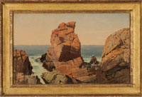
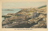
| Spouting Horn |
| • |
Google Maps | Google Earth - Google |
| • |
"..Spouting Horn...also shown here in the 1890s. This was a rock formation that, when hit by surging waves at high tide, would dramatically spew water into the air. It no longer spouts...", Nahant: Images of America, Mathias, Turino, pg. 20, 1999 - Google ebook preview |
| • |
Spouting Horn (Cape) - USGS Geographic Names Information System
Variant name: Shouting Rock |
|
| Sunset Hill |
| • |
Google Maps | Google Earth - Google |
| • |
Map of Lynn and Saugus, Alonzo Lewis, 1829 - Norman B. Leventhal Map Center, Boston Public Library |
| • |
"...The hill which the report mentions with this road is now called Sunset Hill. By some curious and now unknown accident the name of this hill was changed. Formerly it was Fox Hill, and it was so entered upon the Alonzo Lewis map. Sunset Hill was on High Street just above the cemetery chapel. Today Fox Hill is the hill over near Castle Road and Fox Hill Road; Sunset Hill is the former Fox Hill; while the former Sunset Hill has no place name....", Wison, pg. 31, 1928 - Hathitrust |
|
| West Cliff |
|
|
|
 |
|
 |
|
 |
|
 |
|
 |
|
 |
|
 |
|
| Baileys Hill |
 |
|
 |
|
| Castle Rock |
 |
|
 |
|
 |
|
 |
|
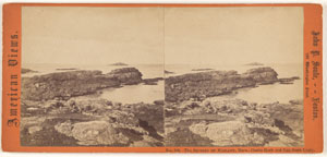
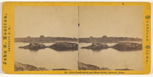
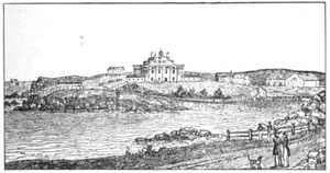
| East Point |
 |
|
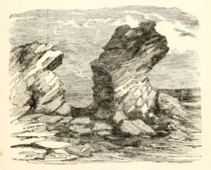
| Pulpit Rock |
 |
|
 |
|
 |
|
 |
|
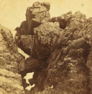
| Spouting Horn |
 |
|
|
|
| More about Nahant's USGS-listed hills |
|
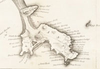
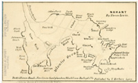
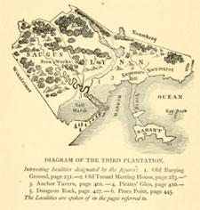
Nahant’s 13 USGS-listed features – not including off-shore islands or beaches – are a collection of capes, islands, bars, ridges, cliffs, and only one summit, Baileys Hill (62 ft.). Alonzo Lewis (1794-1861) – Lynn, surveyor, newspaperman, publisher, and teacher – identified Bayley's Hill on his 1829 map of Nahant, and mentioned it in his book History of Lynn written the same year. But he did not say who the hill was named after. He does identify a man named Theophilius Bayley, who in 1664 received a license for a public house to sell liquor, but not in Nahant. Only one other USGS-listed feature incorporates a person’s name, and it’s a first name, Johns Peril (0 ft. Bar). The tale is written of a John Breed who lost a cart off a cliff at the location, hence his peril. The USGS calls it a bar (which can include a ledge), but not a cliff, and the coordinates place the feature slightly offshore. The Breed family has an interesting place in Nahant history. They are identified as one of three families living in Nahant in 1800. The other two were the Johnsons and the Hoods. Allen Breed (Bread) (c.1599-1691) was an early immigrant to New England arriving possibly with the Winthrop fleet in 1630, though his name is on none of the existing passenger lists.1 In 1638, he is recorded as receiving land in the part of Saugus that would become Lynn. In 1639, he is part of a group of men from Lynn who chartered a boat and sailed to Southampton, New York to establish a new settlement there. But Breed returned to Lynn. Two of Allen Breed’s descendants living on Nahant in the early 1700s were the brothers Samuel Breed (1692-1768) and Jabez Breed (1696-1778). They both were Quakers and they both married descendants of another early settler in Lynn, William Basset (1621-1684). Samuel’s wife was Deliverance Bassett (1695-1724). Her mother Sarah (Hood) Bassett was accused and tried for witchcraft. Jailed for almost six months, she gave birth shortly after she was released, and named the baby girl Deliverance.2 |
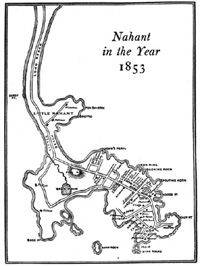
| Though officially listed as being settled in 1630, there were periods of time when no one lived in Nahant. The peninsula was initially cleared of all its trees, then used as a place to keep cattle, collect seaweed for fertilizer, and fish. The name Nahant is Native American with some difference of opinions on its origin. Nahanteau, or Nahanten, has been translated as meaning united or twins, referring in the case of Nahant to the two islands. Others think that Nahant means "the point" or "almost an island." Then there is a Nahanton Hill in the Blue Hills Reservation named after a Native America sachem. Originally part of Lynn, when the temperance movement threatened the summer resort trade in 1853, Nahant incorporated as a separate town. |
| Except for the one hill, Baileys Hill, all the other USGS-listed geographic names are features of Nahant’s rocky shoreline. The names of six relate to their physical appearance, Black Mine (10 ft. Bar), Black Rock Point (0 ft. Cape), Castle Rock (0 ft. Island), Forty Steps (23 ft. Cliff), Great Ledge (3 ft. Island), and Spouting Horn (0 ft. Cape). Two were likely named for the abundant fish that could be caught there, Bass Point (10 ft. Cape) and Bass Rock (0 ft. Island). The names of the three relate to their ordinal directions – East Point (16 ft. Cape), Eastern Point (23 ft. Ridge), and West Cliff (0 ft.) – and not interesting in themselves, but there are interesting people who lived on them. |
| Visitors to Nahant in the late 1700s who wanted to stay overnight, could find accommodations with one of the three Quaker families living on the peninsula. One of those visitors was Thomas H. Perkins (1764-1854). To put a time reference on his life, he was six years old when a neighbor took him to see the body of one of the men that had been killed the day before at the Boston Massacre, March 5, 1770. One of ten children, and starting with very little money or no college education, he would create a business that would help transform Boston from a small port in New England to one of the most influential cities in America. He is known as the Merchant Prince of Boston and is credited as one of the first American merchants to open a permanent trading office in Canton (now Guangzhou) shortly after China opened the port.3 He became tremendously wealthy, as did members of his extended family that he brought into the business. Perkins & Co. would employ Ralph B. Forbes (1773-1824), he married Thomas’ sister Margaret (1773-1856). Their three sons, James, Thomas, and Robert, all worked for company. Thomas Perkins’ daughter Eliza Perkins (1781-1885), married Samuel Cabot Jr. (1784-1863). He entered the family business in 1838. As did John P. Cushing (1787-1862), also a nephew of Thomas Perkins, after the death of his mother, he had been raised by his uncle. At 16 he sailed to China to become a clerk at Perkins & Co, office. The family names that made their fortunes at Perkins & Co. read like a who’s who of the Boston elites who would become known as the Boston Brahmin. The wealth of Cabot, Cushing, Forbes, and Perkins families provided much of the wealth that transformed Boston. |
| Thomas H. Perkins was a philanthropist. He is the Perkins in Perkins School for the Blind, named in his honor after he donated his Boston mansion to the institution. He donated money for the building of the Bunker Hill Monument, and he owned the Granite Railway that was used to carry granite for its construction. One of the first commercial railroads in America. He was benefactor to the Boston Athenaeum, Boston Museum of Fine Arts, McLean Hospital, and helped found the Massachusetts General Hospital. On the darker side, Thomas Perkins earlier worked in the slave trade, and later made much of his money in the China trade smuggling in Turkish opium. |
|
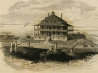
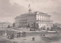
Thomas H. Perkins interest in Nahant started with his first stays with the Hood family in the late 1700s. As early as 1817 he bought land above the Spouting Horn and built a cottage. In 1821 he bought all of East Point with partners and in 1823 opened the Nahant Hotel there, one of the first ocean resort hotels in America.4 This less than 10 years after the end of the War of 1812, and well before the popularity of resort hotels in the late 1800s. The hotel would be remodeled, updated, enlarged, and remain in operation until the mid-1850s. But the economic downturn of Panic of 1857, signs of a possible Civil War, and changing consumer trends would ultimately lead to the demise of the hotel. It burned to the ground in 1861 and wasn’t rebuilt. Perkins had sold out his interest in 1843. Nahant was falling out of favor as a hotel destination but would remain popular as a place for a summer retreat. |
|
The early cottages built in Nahant were just that, cottages. The Perkins’ cottage has been demolished, but it was not an imposing structure. One cottage from approximately the same period that still exists was built by John E. Lodge (1807-1862).5 Another merchant who became wealthy in the China trade. Lodge owned multiple clipper ships including the Don Quixote, built in Medford, Mass. A first-generation American, he married Anna Sophia Cabot (1821-1900) in 1842.6 Their son, Henry C. Lodge (1850-1924), would become a U.S. Senator. John Lodge in the year he died purchased East Point after the hotel burned down. He divided the property between his two children, Henry and Elizabeth (1843-1908). She would marry George A. James (1838-1917), and both families would build substantial houses on East Point.7 Both houses would be demolished when the U.S. Military built a military base there. After the military abandoned the base, East Point became the location of the Northeastern University Marine Science Center, and Lodge Park, named for native son Henry C. Lodge, Jr. (1902-1985), a U.S. Senator. |
|
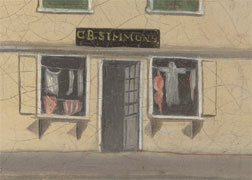
The other USGS-listed feature with “east” in its name is Eastern Point (23 ft. Ridge), located at the end of Little Nahant. In the 1880 G.M. Hopkins Atlas for Nahant almost all Little Nahant is shown as being owned by George W. Simmons (1810-1882). He and his uncle John Simmons (1796 -1870) are credited with revolutionizing the way clothes were made, how clothes were merchandized, and where clothes were bought. George Simmons’ family were not wealthy merchants or China traders. His father, Cornelius B. Simmons (1785-1822), moved from Little Compton, R.I. to Boston in 1810 to learn the tailor trade. He opened what was called a slop-shop. At that time, most clothing was made for an individual and would take days or weeks to be completed. This wasn’t practical for the most sailors in Boston who could leave at any time for long voyages. They bought cheap ready-made clothing and bedding called slops, named for the short, baggy trousers sailors wore, at Simmons’ shop. |
| In 1814, John Simmons, George’s uncle, followed his older brother up to Boston to work in his tailor shop.8 The idea he capitalized on was to manufacture finer ready-to-wear clothing and make available in common sizes to be sold at set prices. To make his clothing, he first had cloth cut to pre-determined patterns at his shop in Boston, then it was sent out to be sewn by women who could make money doing piece work. Garments would then be returned and pressed into proper shape. John was an early adopter of the new sewing machine and was one the first to send out traveling sales agents. Within 20 years, John was running the largest wholesale clothing business in New England. He was a wealthy man, and in the early 1840s began to withdraw from the business to focus on real estate investing in Boston. |
|
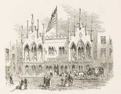
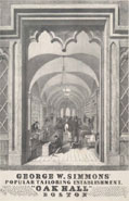
George Simmons took over the ready-to-wear clothing business from his uncle and focused on retail sales.9 In 1842 he replaced the old slop-shop with a new enlarged and renovated store featuring large display windows, an ornate oak entrance, oak paneling inside, a full selection of fashionable men’s and boy’s ready-to-wear clothing (women’s ready-to-wear clothing would not be available until later in the 1800s), and attentive sales clerks. Named Oak Hall for its extensive use of oak, it was a precursor of modern stores, and Simmons clearly understood destination shopping. His vigorously marketed the store using newspaper advertising, flyers, catalogs, calendars, mailers, children’s coloring books. He was a pioneer in outdoor advertising having handbills and posters pasted in locations across New England. Henry Thoreau described seeing one wrapped around a tree while hiking is his story, The Maine Woods, commenting wryly that now moose and otter could learn where to buy fashionable clothes. There is another story that a tourist after climbing to the nose of “the Old Man in Mountain” in New Hampshire, looked up and saw a handbill saying, “Visit Oak Hall, Boston.” Back in Boston, Simmons would stage events releasing balloons from the top of his store, some carrying coupons for a free overcoat. Simmons was so successful in equating the brand “Oak Hall” with fashionable, high quality, lost-cost clothing, that other stores in the country opened with the same name. Even today there are Oak Hall stores and clothing lines, likely sold without an understanding on where the name originated. |
| Both John and George Simmons made additional contributions to Boston. John Simmons was the founder of Simmons College. When he died in 1870, his estate provided for the establishment of a college where women could study subjects they could use to support themselves. The opening of the college was delayed until 1899 because the Great Boston fire of 1872 destroyed much of the property he owned. Ironically, it was George Simmons who played in a role in saving the historic Old South Meeting House in Boston after it was almost destroyed in the same fire. The building had been sold at auction and dismantling had already begun when George Simmons secured a seven-day delay by saying he would be responsible for raising the last $100,000 needed for its purchase. The funds were raised, and the building was saved. One of the noted speakers at the meeting to save the old church was the abolitionist Wendell Phillips, and he has also has a connection to Nahant. |
| In the 1880 G.M. Hopkins Atlas for Nahant the label for the USGS-listed West Cliff (0 ft. Cliff) is on the property of the J.C. Phillips estate. The Phillips family in New England dates back to the very beginnings of the Puritan migration. George Phillips (1593–1644) immigrated to New England in 1630 onboard the Arbella with John Winthrop. He was the first pastor of the church in Watertown, Mass. and preached a more tolerant form of puritanism that was a precursor of Congregationalism in New England.10 The Phillips of Nahant are descendants of John Phillips (1770–1823). He was descended from the John Phillips (1719-1795) that founded Phillips Academy Exeter. That John Phillips’ nephew, Samuel Phillips, Jr. (1752–1802), founded Phillips Academy Andover. The John Phillips of Nahant was president of Massachusetts Senate and the first mayor of the city of Boston. But is likely he never lived in Nahant, possibly never visited. He and his wife Sarah (Walley) Phillips (1772-1845), married in 1794, had nine children from 1797 to 1816. He died in 1823, and it isn’t until 1838, when their son Wendell Phillips (1811-1884), the orator that helped save the Old South Meeting House, mentions visiting his mother's estate on Nahant. |
| Even though he doesn’t have a connection to a USGS-listed hill in Nahant, Frederic Tudor (1783-1864) does have an interesting connection to an important feature of Nahant, its trees.11 And, he was an interesting individual who came to be known as the Ice King. The Tudor family in New England dates back to 1715 when six-year old John Tudor (1709-1795) was brought by his widowed mother Mary (____) Tudor (c.1679-1715) to Boston. She was a baker, and she set up shop on White Bread Alley (today’s Harris St.) where she is credited as being the first baker in Boston to sell Penny Rolls (also called Penny Buns), small loaves of bread sold for a penny. John became very successful as a baker and as an investor in real estate in Boston owning valuable wharf space. He also purchased land in Lynn (now Saugus) establishing a farm he called Rockwood, and in 1787, began can buying land in Nahant (also then part of Lynn). John Tudor married Jane Varney (1714-1795) in 1732. Their surviving son was William Tudor (1750-1819). Harvard graduate, studied law in the office of John Adams, appointed by George Washington Judge Advocate of the Continental army, State Senator, Secretary of the Commonwealth, one of the founders the Massachusetts Historical Society, clearly a prominent citizen. He married Delia Jarvis (1752-1843) and one of their sons was Frederic Tudor. |
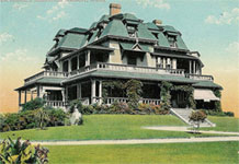
|
In 1805, at age 22, Frederic Tudor pioneered, and was widely ridiculed for, the idea of cutting ice from ponds around Boston and shipping it to ports in the Caribbean. His initial shipments reached their destination but melted before being sold. Overcoming obstacles, including bankruptcies and stints in debtor’s prison, by 1816 he was successfully shipping ice insulated with sawdust to the special warehouses in the Caribbean and southern U.S. cities, and eventually, by the 1840s, to England, South America, China, and Australia. In 1825, now a wealthy man, Tudor built a stone cottage on family land in Nahant as a summer residence. The building still exists, now expanded, it is used as the Nahant Country Club. The Nahant peninsula at that time was completely stripped of all large trees. Initially forested, the trees had been chopped down in the 1650s as part of a plan by early Lynn town officials to use the peninsula for pasture and farming. Despite critics would said trees would never survive the winds from ocean storms, Tudor began a life-long campaign to reforest the peninsula. First planting fast-growing poplars as windbreaks, he methodically spent the rest of his life planting an estimated 4,000 trees on the peninsula. Starting saplings in his own nursey, he gave away trees for free to anyone who would plant them. He had orchards with apple, pear, and plum trees. In 1860 Tudor opened one of the earliest amusements parks he called Maolis Gardens. Visitors could picnic by the ocean, ride swings and tilt boards, view trained bears and other animals in cages. There were ice cream parlors, dining halls, a tea house, fountains, pavilions and a small hotel. By the later 1800s, larger, easier-to-get-to amusements parks were opening, and Maolis Gardens was closed and the land sub-divided for houses. |
| Not included in this survey are USGS-listed off-shore islands and ledges, and beaches and coves. Caverns, caves, or grottos are not listed by the USGS in its GNIS database. |
|
|
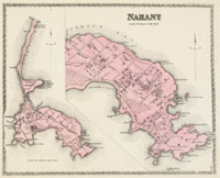
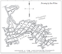
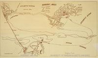
| Nahant Maps |
| • |
Nahant - Google Maps, Terrain |
| • |
Nahant - MassMapper MassGIS |
| • |
Nahant - USGS - The National Map |
| • |
Lynn Quadrangle - 2018 (40 MB PDF) - USGS Topo Download |
| • |
Map of Lynn and Saugus, Alonzo Lewis, 1829 - Norman B. Leventhal Map Center, Boston Public Library |
| • |
Nahant, D.G. Beers & Co., 1872 - Salem State University Library |
| • |
Atlas of Nahant, Massachusetts, G.M. Hopkins, 1880 - State Library of Massachusetts |
| • |
Nahant Town, Geo.H. Walker, 1884 - Historic Map Works |
| • |
Atlas of Nahant, Massachusetts, Geo. W. Stadly, 1896 - State Library of Massachusetts |
| • |
Atlas of Nahant, Massachusetts - State Library of Massachusetts |
| • |
Nahant Heritage Trail Map (PDF) - Nahant Open Space Committee, Town of Nahant |
| • |
Atlases - Southern Essex District Registry of Deeds |
| • |
MapJunction |
|
|
| Nahant Sources |
| • |
History of Lynn, Alonzo Lewis, 1829 - Internet Archive |
| • |
Nahant, Standard History of Essex County, Massachusetts, Embracing a History of the County from its First Settlement to the Present Time, Cyrus M. Tracy, 1878 - Internet Archive |
| • |
Letters from Nahant, Historical, Descriptive and Miscellaneous, William W. Wheildon, 1842 - Hathitrust |
| • |
Nahant, A Collection from Sundry Sources of some Noteworthy Descriptions of the Town, Nahant Public Library, 1899 - Hathitrust |
| • |
Some Annals of Nahant, Massachusetts, Fred A. Wilson, Nahant Historical Society, 1928 - Hathitrust |
| • |
Lovely Nahant, Hotel Tudor, 1897 - Hathitrust |
| • |
An Historical Address Delivered at the Celebration of the Fiftieth Anniversary of the Incorporation of the Town of Nahant, July 14, 1903, Henry C. Lodge, 1904 - Hathitrust |
| • |
The Picture of Nahant, Alonzo Lewis, 1855 - Hathitrust |
| • |
Nahant, History of Essex County, Massachusetts, with Biographical Sketches of Many of its Pioneers and Prominent Men, Edward J. Johnson, Duane Hurd, 1888, Vol. 2 - Internet Archive, HathiTrust |
| • |
Sketches of Nahant Showing Many Points of Interest, Eugene H. Brann, 1911 - Hathitrust |
| • |
History of Lynn, Essex County, Massachusetts, including Lynnfield, Saugus, Swampscott, and Nahant, 1629-1864, Alonzo Lewis, James R. Newhall, 1890 - Internet Archive |
| • |
History of Lynn, including Nahant, Alonzo Lewis, 1844 - Internet Archive |
| • |
Nahant, and other places of the North-Shore, James L. Homer, 1848 - HathiTrust |
| • |
The Nahant Public Library, Fred A. Wilson, 1895 - HathiTrust |
| • |
The Geology of Nahant, Alfred C. Lane, 1888 - Hathitrust |
| • |
Geology of the Igneous Rocks of Essex County, Massachusetts, Charles H. Clapp, USGS, Dept. of the Interior, 1921 - Google ebook |
| • |
Nahant S.W.I.M. Inc. (Safer Waters in Massachusetts) |
| • |
Nahant: Images of America, Christopher R. Mathias, Kenneth C Turino, 1999 - Google ebook preview |
| • |
Nahant, Poetry of Places in Essex Count - North Shore Community College |
| • |
Nahant, A Gazetteer of the State of Massachusetts with Numerous Illustrations, Elias Nason, 1890 - Internet Archive |
| • |
Nahant Harbor View Archive - Nahant Online |
| • |
History of Egg Rock Light, Nahant, Massachusetts - New England Lighthouses: A Virtual Guide |
| • |
Nahant Open Space & Recreation Plan, 2016 - Town of Nahant |
| • |
Nahant Reconnaissance Survey Town Report (PDF), 2005 - Massachusetts Department of Conservation and Recreation |
|
|
| Footnotes |
| 1 |
A Record of the Descendants of Allen Bread who came to America from England in 1630 , John H. Bread, 1892 - Internet Archive |
|
Breed Genealogy, Genealogical and Personal Memoirs Relating to the Families of Boston and Eastern Massashusetts, Vol. 4, 1908, pg. 1732, William R. Cutter - Google ebook |
|
Breed, Sidney Perley, The Essex Antiquarian, Vol. 11, pg. 145, 1907 - Google ebook |
|
Breed Family (PDF) - The Earlville Post |
|
Historical Document Collection - Town of Southhampton, Long Island, New York |
|
Samuel Breed (1669-1755) - Kristin C. Hall |
| 2 |
Sarah Hood Bassett (1657-1721) - Salem Witch Museum |
|
Deliverane Bassett (1695- ) - Bassett Family Association |
| 3 |
Merchant Prince of Boston : Colonel T.H. Perkins, 1764-1854, Carl Seaburg, Stanley Patterson, 1971 - Internet Archive |
|
How Profits From Opium Shaped 19th-Century Boston, Martha Bebinger, 2017 - WBUR |
| 4 |
Resort Architecture at Nahant 1815-1850 - Historic New England |
|
Nahant Hotel, c. 1824 - Tides Institute and Museum of Art |
|
Nahant: A Report Forerunner, Summer by the Seaside: The Architecture of New England Coastal Resort Hotels, Bryant F. Tolles, Jr., 2008 - Google ebook preview |
|
The Eastern Shore, Illustrated Hand-book of American Summer Resorts, Vol. 21, pg. 104, 1896 - Google ebook |
|
The Nahant Quadrilles, 1836 - Fitz Henry Lane |
|
Some Background on Nahant’s History as a Summer Resort and the history of the Nahant Vintage Dance Balls - Vintage Victorian |
| 5 |
Henry Cabot Lodge Residence - MACRIS, Massachusetts Historical Commission |
| 6 |
Spotlight on Collections: The Lodge Papers, Part 2 - Massachusetts Historical Society |
| 7 |
Henry Cabot Lodge House, Porter Lodge, Outbuilding and Stable Renovation - David J. Russo |
| 8 |
The Ancestry of John Simmons, Founder of Simmons College, Henry S. Rowe, 1933 - HathiTrust |
|
Guide to the John Simmons Papers, 1813-2005 - Simmons Library |
|
About John Simmons, Denise D. Pappas - John Simmons, The Measure of a Man |
|
Benoni Simmons (1755-1835), Chuck Simmons, John Concannon - Gaspii Virtual Archives |
|
How Clothing Innovation Helped Educate Thousands of Women: John Simmons and the Founding of Simmons College - Computer Images |
|
John Simmons, Founder of the Boston Women's College, Phrenological Journal, pg. 367, 1871 - Google ebook |
|
Simmons College Boston - Lost New England |
|
The slop shop and the almshouse: ready-made menswear in Philadelphia, 1780-1820, Tyler Putman, 2011 - University of Deleware Library |
| 9 |
Oak Hall, or The Glory of Boston; a Poem: by a Young Gentleman of Boston, George W. Simmons, 1846 - Google ebook, HathiTrust |
|
An Epitome of Times and Fashions, Crossings in Text and Textile, pg. 36, Katherine Joslin, Daneen Wardrop, 2015 - Google ebook preview |
|
The Boston Clothing Industry, The Clothier and Furnisher, Vol. 11, pg. 13, 1881 - Google ebook |
|
The Clothing Manufacturer, Bulletin of the National Association of Wool Manufacturers, Vol. 4, pg. 17, 1873 - Google ebook |
|
Boston and the East, The American Hatter, Vol. 38, pg. 81, 1909 - Google ebook |
|
Oak Hall, or The Glory of Boston; a Poem: by a Young Gentleman of Boston, George W. Simmons, 1846 - Google ebook, HathiTrust |
|
Oak Hall Pictorial, George W. Simmons, 1854 - HathiTrust |
|
The Bandsmen Series, George W. Simmons, 1888 - Brown University Library |
|
Oak Hall Clothing Co., Stamp holder and pocket calendar, 1900 - The National Museum of American History |
|
George W. Simmons' Popular Tailoring Establishment, Oak Hall, 1844 - Fitz Henry Lane |
|
Oak Hall Outline Book for Juvenile Artists, G.W. Simmons & Son, Oak Hall, c. 1880s - Internet Archive |
|
Oak Hall Bill, George W. Simmons, Oak Hall, 1855 - Columbia University Libraries |
|
The New Bicycle Buttons, G.W. Simmons, Oak Hall, The Bicycling World, 1883 - Internet Archive |
|
The Oak Hall Ballons, The Pilot, 1873 - Boston College Libraries |
|
Oak Hall, Boston Gentlemen's Clothing, Boston Evening Transcript, 1878 - Google News |
| |
The Maine Woods - Henry David Thoreau Online |
|
Second Paper, Forty years an advertising agent, 1865-1905, pg. 27, George P. Rowell, 1906 - Google ebook |
|
History of the Old South Meeting-house in Boston, Vol. 50; Vol. 282, pg. 89, Everett W. Burdett, 1877 - Google ebook |
|
The Heroic Last-Minute Rescue of the Old South Meeting House - New England Historical Society |
| 10 |
Memoir of John Phillips, First Mayor of the City of Boston, The New England Historical and Genealogical Register, Vol. 20, pg. 26, 1866 -Google ebook |
|
John Phillips, Boston's 45 Mayors: From John Phillips to Kevin H. White, pg. 3, Joseph J. Fahey, 1975 - Internet Archive |
|
Wendell Phillips: The Agitator, pg. 148, W. Carlos Martyn. 1890 - HathiTrust |
| 1` |
Frederic Tudor, The Ice King Cometh, The Ice Entrepreneu (PDF), pg. 15, 2005 - Nahant Harbor Review |
|
Frederic Tudor, The Ice King Cometh, The Ice Entrepreneu (PDF), pg. 15, 2005 - Nahant Harbor Review |
|
Frederic Tudor Ice King, Taken from the Proceedings of the Massachusetts Historical Society November, 1933 - Ice Harvesting U.S.A. |
|
Frederic Tudor, the Ice King, W. Carlos, 2003 - Harvard Business School |
|
Frederic Tudor House - MACRIS, Massachusetts Historical Commission |
|
The Tudor Family - Nahant Country Club |
|
Tudor Barn - MACRIS, Massachusetts Historical Commission |
|
Frederic Tudor Ice King - Ice Harvesting USA |
|
Industry and Invention, pg. 77, Milestone Memorisla akong Newburyport Turnpike, pg. 130, The Register of the Lynn Historical Society, Lynn, Massachusetts, 1913 - Google ebook |
|
William Tudor Papers - Massachusetts Historical Society |
|
Cool Customer, Frederic Tudor and the frozen-water trade, Jason Zasky, 2003 - Failure Magazine |
|
The Ice King - Frederic Tudor, Yankee entrepreneur/ - BridgeSEC |
|
William Tudor (1779-1830) - Harvard University Archives |
|
In Love With A Loyalist - New England Historical Society |
|
Deacon Tudor's Diary, William Tudor, 1896 - Internet Archive |
|
John Tudor - Massachusetts Historical Society |
|
Bakers and Baking in Massachusetts, pg. 84, Arthur Brayley, 1909 - Google ebook |
|
A Call to the Sea, Claude G. Berube, John Rodgaard, 2006 - Google ebook preview |
|
The Trees of America, Richard V. Piper, 1855 - HathiTrust |
|
Mr. Tudor's Garden at Nahant, Rural Essays, A.J. Downing, 1847 - Google ebook |
|
Trees in Nahant (PDF), Barbara Warren, 2016 - Nahant SWIM |
|
|