| Hills of Melrose, Mass. |
| | Hills | More about Melrose's USGS-listed hills | Maps | Sources | |
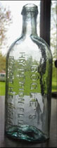
| Atlantic Rock |
| • |
"...These local summits are Mount Zion, Mount Hood, Boston Rock, Atlantic Rock, Barrett Mount and Vinton Hill or West Rock...", Hurd, pg. 206, 1890 - Internet Archive |
|
| Barrett Mount |
| • |
Google Maps | Google Earth - Google |
| • |
"...His homestead stood near Barrett Mount, on the southerly side of Maple Street, about twenty rods west of Vinton Street...", Ancient Melrose, pg. 39, 1914 - Internet Archive |
| • |
"...These local summits are Mount Zion, Mount Hood, Boston Rock, Atlantic Rock, Barrett Mount and Vinton Hill or West Rock...", Hurd, pg. 206, 1890 - Internet Archive |
|
| Black Rock |
|
| Boston Rock |
| • |
Google Maps | Google Earth - Google |
| • |
"...Nearer the center of the town, yet in the southerly part, on the easterly side of the valley), Boston Rock commands a wonderfully charming landscape; the valley below with the extensive plant of the Boston Rubber Shoe Company, and the still remaining old-time Lynde homesteads, and many highly cultivated acres...", Goss, pg. 25, 1902 - Internet Archive |
| • |
"...Capt. John Lynde, who received from his father, Ensign Thomas, the northern part
of the farm, left the old original house at the foot of Boston Rock and built his new house
in 1693, and it stood where lived the late Warren Lynde...", Ancient Melrose, pg. 24, 1914 - Internet Archive |
|
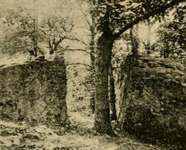
| Cleft Bolder |
| • |
Google Maps | Google Earth - Google |
| • |
"...A natural curiosity existed on the southern part of this Vinton farm, and now belongs to the estate of Mrs. Benjamin F. Dyer, No. 44 Orris Street. It is an immense 'Cleft Boulder,' or natural gateway to the woods beyond, a view of which is here given. The space between its walls is wide enough for
a carriage drive, and it has a large oak tree growing therein. It is an interesting specimen and relic of the glacial age. It has been called by some "Chapel Rock" - why I know not...", Goss, pg. 128, 1902 - Internet Archive |
|
| Dexters Rocks |
|
| High Rock |
| • |
USGS identified - MassMapper MassGIS |
| • |
Google Maps | Google Earth - Google |
| • |
"...Jonathan and Peter Green resided on Green Lane; near the foot of Vinton's Hill now in Melrose Highlands was the house of Ezra Vinton...", History of Stoneham, Massachusetts, pg. 67, William B. Stevens, 1891 - Internet Archive |
| • |
"...West Hill, erstwhile called 'Vinton Hill,' then 'High Rock,' situated in the northwest corner of Melrose, near the Stoneham and Wakefield line, easily accessible from Franklin Street, affords another view of this charming scenery...", Goss, pg. 28, 1902 - Internet Archive |
| • |
Melrose Open Space & Trails Pocket Guide (PDF), 2009 - City of Melrose |
| • |
Thomas Vinton House: "...The original Vintons were very prominent in civic affairs in Melrose and Stoneham in the 18th century. Thomas and his brothers, Timothy and Ezra, belonged to Captain Sprague's "Minute Men" who marched from Stoneham to Lexington when the alarm was sounded in 1775...." - Massachusetts Historical Commission Information System (MACRIS) |
| • |
High Rock - USGS Geographic Names Information System |
|
| Melrose Rock |
|
| Mount Ephraim |
| • |
Google Maps | Google Earth - Google |
| • |
"...On its eastern border rises Mt. Ephraim, up which a carriage road has been constructed to the top...", Goss, pg. 68, 1902 - Internet Archive |
| • |
About the Park: "...Some of the natural features of Pine Banks Park are hundreds of large evergreens, especially white pines and cedars, rocky ledges, Mount Ephraim, lookouts, a pond and wildlife. ...." - Pine Banks Park |
| • |
Pine Banks, "...The largest cliff, which is made of solid bedrock, rises 40–50 feet straight up to form Mount Ephraim, which overlooks the whole park...." - Wikipedia |
| • |
Pine Banks Park : "...Two sections have higher elevations, including the large area surrounding Mount Ephraim to the east and another high area on the west surrounding a small pond, once known as the Summit and Island Pond, respectively...." - Massachusetts Historical Commission Information System (MACRIS) |
|
| Mount Hood |
| • |
USGS identified - MassMapper MassGIS |
| • |
Google Maps | Google Earth - Google |
| • |
Mt. Hood "...Tradition states that upon this summit the Wampanoag Indians, whose Sachem in early Colonial times was Massasoit, lighted the signal fires by which they comnumicated with other friendly tribes as far away as Mt. Wachusett, near the foot of which dwelt another tribe of "good" Indians with whom they engaged in barter and exchange....", Ancient Melrose, pg. 13, 1915 - Internet Archive |
| • |
"...Some fifteen years ago, Mr. Wendell P. Hood built a small house on the top of this mount,
sunk a well, set out fruit trees, and ploughed and sowed several of the surrounding acres with grain...", Goss, pg. 24, 1902 - Internet Archive |
| • |
History of Mount Hood Park: "...Mount Hood was known as “Bear Hill” by the Wampanoag Indians, who used its elevation to signal native tribes as far west as Mount Wachusett. In 1907, John C. Slayton purchased 25 acres of land from Wendell P. Hood and constructed a tower at the summit and an access road..." - Mount Hood Park Association |
| • |
Mount Hood Recreational Center: "...Once known as Bear Hill, Mount Hood is located in the southeastern part of Melrose near the Saugus line..." - Melrose Public Library, NOBLE Digitak Heritage |
| • |
Mount Hood - USGS Geographic Names Information System |
|
| Mount Zion |
| • |
Google Maps | Google Earth - Google |
| • |
"...Mt. Zion, in the extreme northeast...." - Goss, pg. 29, 1902 - Internet Archive |
| • |
"...These local summits are Mount Zion, Mount Hood, Boston Rock, Atlantic Rock, Barrett Mount and Vinton Hill or West Rock...", Hurd, pg. 206, 1890 - Internet Archive |
|
| Pine Banks |
| • |
USGS identified - MassMapper MassGIS |
| • |
Google Maps | Google Earth - Google |
| • |
About the Park: "...The site reportedly belonged originally to the Wampanoags in the early 1660s and the Lynde family in the early 1700s...." - Pine Banks Park |
| • |
"...The original Ensign Thomns Lynde farm was large, embracing what is now the Wyoming Cemetery, Pine Banks Park, and extended to and beyond Forest Street...", Goss, pg. 45, 1902 - Internet Archive |
| • |
Pine Banks Park, "...Its earliest history was as a traditional New England farmstead, but it was acquired by a wealthy philanthropist in 1881 and was designated a public park by about 1889...
...Two sections have higher elevations, including the large area surrounding Mount Ephraim to the east and another high area on the west surrounding a small pond, once known as the Summit and Island Pond, respectively..." - Massachusetts Historical Commission Information System (MACRIS) |
| • |
Pine Banks Park Gatekeeper Lodge, "...The Lodge serves as gate keeper's hose to Pint Banks Park established 1884 as a provide wwodland preserve by Elisha S. Converse..." - Massachusetts Historical Commission Information System (MACRIS) |
| • |
Pine Banks - USGS Geographic Names Information System |
| • |
Pine Banks Park (Park) - USGS Geographic Names Information System |
|
| Pine Hill |
| • |
USGS identified - MassMapper MassGIS |
| • |
Google Maps | Google Earth - Google |
| • |
"...the old Jonathan Barrett homestead lot of twenty-one acres, the Pine Hill lot of fourteen acres, and a few other small lots....", Ancient Melrose, pg. 39, 1902 - Internet Archive |
| • |
"...This rolling land, lying between Porter and Howard Streets, on the slope of Pine or Rattlesnake Hill, is admirably adapted to this purpose, giving ample scope for its course....", Golf History - Belleve Golf Club |
| • |
Pine Hill - USGS Geographic Names Information System |
|
| Reading Hill |
| • |
Google Maps | Google Earth - Google |
| • |
"...Francis Hemenway, whose farm was on the easterly side of East Street, corner of Porter, was born in Stoneham in 1797, but came to Melrose when he was a year old. In 1815, there occurred an Indian mock fight, in which Mr. Hemenway took part. Some six hundred Maiden and Reading men, arrayed in war-paint and feathers, tomahawks and scalping knives, were pitted against several mihtary companies from Charlestown and other towns. The battle began on Reading Hill, north of Green Street....", Ancient Melrose, pg. 60, 1915 - Internet Archive |
|
| Upham Hill |
|
| White Rock |
|
|
|
 |
|
 |
|
| Cleft Boulder |
 |
|
| Mount Ephraim |
 |
|
| Mount Hood |
 |
|
 |
|
 |
|
| White Rock |
 |
|
 |
|
|
|
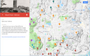
| More about Melrose's USGS-listed hills |
|
Melrose was part of Malden when it split off from Charlestown in 1649. North Malden, as it was known, was sparsely populated when in 1845 the Boston and Maine Railroad ran a line north through Malden into Wakefield. Easy access to Boston encouraged rapid growth and in 1850 a citizen petition to separate from Malden was accepted with the new town taking the name Melrose. It was named after a small town in Scotland, but which of two citizens suggested the name is a matter of some controversy. Both were recent immigrants from Scotland, and both had recently moved to the area. One was John McLeish (1809-1867), pastor of the Methodist Church, and the other, William Bogle (1817-1891), a wig maker, hairdresser, and manufacturer of “hair dyes, perfumery, and proprietary articles.”1 Three histories of Melrose - written in 1902, 1915, and 1950 – each give credit differently. |
|
In one telling, Bogle and McLeish were both at a meeting where it was McLeish who said, “I know a beautiful little town in Scotland…”. In another telling, McLeish wasn’t at a meeting where the final decision was made, and Bogle suggested the name. This makes some sense because in 1849 McLeish caught “gold fever”, formed the Middlesex and California Gold Company, and with his son boarded the Sea Eagle bound for California around Cape Horn.2 They never did find gold, and the two returned in 1851. So McLeish would have been gone when in 1850 North Malden became Melrose. The two are reported to have been friends and involved in a land deal. It is Bogle who is credited with naming Wyoming Ave. in 1843, possibly basing it on the valley in Pennsylvania that was a site of revolutionary war battle. At some point in time McLeish left Melrose, his wife died in New York in 1865, and he died in New Orleans in 1867. Bogle would stay in area making a fortune selling “Hyperion Fuild” for “the preservation, growth and beauty of the Hair.” In his 1846 pamphlet, The Anatomy and Physiology of the Hair,3 the "Artist in Hair" touts his knowledge. Bogle would stay in Melrose for the rest of life, become a prominent citizen, benefactor to the Melrose Public Library, the Scots Charitable Society, a Mason, and member of the Ancient and Honorable Artillery Company of Massachusetts. In 1899, Melrose became incorporated as a city. |
| Melrose has six USGS-listed hills, Black Rock (246 ft.), High Rock (230 ft.), Melrose Rock (197 ft.), Mount Hood (256 ft.), Pine Banks (203 ft.), Pine Hill (187 ft.). Mount Hood is the only hill will a family name. |
| Wendell P. Hood (1839-1899) was a descendant of the John Hood (c.1600-1683).4 who had immigrated by 1638 settling first in Cambridge, then in 1650 is living in Lynn. Many generations later, in 1883, Wendell Hood is living in Melrose where he bought land near his house in hope of improving it to become a farm. On that land is a hill that since colonial times appears to only have been known as Bear Hill. There are a number of Bear Hills surrounding the Boston Basin. It is possible that more bears in colonial times were living on those specific hills than other hills. But it is also possible that the early settlers either noticed, or were told by the Native Americans, that certain hills were bare hills, meaning no trees. Melrose historian Goss basically all but admits the incorrect name in his 1902 book when he says that the area contains “numerous high and unwooded summits” and that “Bear Hill…affords the most interesting and far-reaching of these views.” |
|
Wendell Hood had graduated from Phillips Academy in 1860 and entered Dartmouth College. In 1861, just before the start of the Civil War, he transferred to Brown University. Leaving there in 1862, he enlisted in the Rhode Island Volunteers serving in Virginia protecting Washington, D.C. He re-enlisted in 1862 this time with the Massachusetts Volunteers, and served under Major General Nathaniel P. Banks in the unsuccessful Red River Campaign in Louisiana. He caught malaria and was discharged. Back in New England he returned to Dartmouth graduating in 1865, and in the following year married Maria P. Putnam (1843-1929). Then comes a remarkable decision. The couple moves to Red River, Minnesota, well north up the Mississippi River. There is no information readily available on how or why he chose Minnesota, it had become a state less than 10 years earlier. Once there he became Superintendent and Principal of Schools in Red Wing, and Rochester and Winona, nearby towns. What could have been the motivation for the move was the creation of the Red Wing Collegiate Institute in 1870. Hood is on the board and its first principal (his wife was a teacher). Likely modelled after his alma mater Phillips Academy, it was for pupils who lived in rural districts “destitute of first-class educational privileges”, and for those who “seek the culture of Eastern Institutions.” Interestingly the school was co-ed. Phillips would not go co-ed until 1973. But it failed after three years, the building was sold to become a Lutheran Theological Seminary. No reason is given for the failure. Unlike in the Boston area, the Midwest developed a tradition of public land-grant universities and public high schools. The University of Minnesota was established in 1865, and Red Wing’s High School was launched in 1866. Possibly the idea of attending a private prep school to get into a public university was not viable. In 1878 the family in the Boston area, James becomes principal in Nahant, Maria a teacher in Melrose. One other of his accomplishments when he was in Minnesota was to design and patent an improved school desk. |
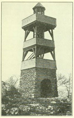
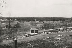
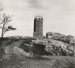
| After Hood died in1889 the farm fell into neglect and was purchased in 1907 by John C. F. Slayton (1856-1922).5 Born in Calais, Vt., Slayton moved to Boston when he was 22 and became very wealthy as commission merchant in the egg and butter business. Settling in Melrose he became active local affairs and great philanthropist in the town. Slayton built a road to the summit of the hill and an observation tower on top. It was destroyed by fire and rebuilt in 1934 as the Slayton Memorial Tower. The park and golf course were completed by the WPA (Works Progress Administration) in 1937. |
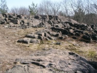
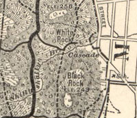
| Black Rock logically gets its name from the geology of the hill. The exposed rock in Middlesex Fells is volcanic in origin and most of it light-colored, but there are intrusions of black rock.6 This specific hill of black rock, one of the highest points in the park, is mentioned in 1640 as the location of grist mill built by Thomas Coytmore (c.1611-1645). An earlier settler in what was then Charlestown, Coytmore unfortunately died in shipwreck off the coast of Spain. His widow Martha remarried John Winthrop, governor of Massachusetts. Upon his death, and the death of a third husband, and of all her children, stricken with grief, she took her own life. 7 |
| Years afterward, in 1806, Black Rock was purchased by three brothers from New Hampshire, George (1764-1846), Thomas (1769-1851) and Ebenezer (1773-1817) Odiorne.8 At the site of the old mill, they established a water-powered cut nail-making factory using a new process that cut and headed nails in one operation. They had purchased the rights to the patent, and it proved very successful making the brothers very wealthy. Unfortunately. Ebenezer would die in an accident at the mill. Along with the land along the Malden river, the brothers also bought the water rights giving them ownership of Spot Pond. The nail-making venture was a success, but technologies would change, and the business expanded elsewhere. What didn’t change was the need for water, not to power mills, but to satisfy the demands from a growing population. In 1843, the Odiornes formed the Spot Pond Aqueduct Company, and offered to sell to Boston a one-third share with rights to Spot Pond and its water.9 Boston passed on the deal, partly because they didn’t believe the pond held enough water, and partly because of the debate if water should be supplied by a public or private entity. The towns or Medford, Malden, and Melrose would tap Spot Pond for a water supply. Then in 1895, the Massachusetts Metropolitan Water would be created and Spot Pond would be absorbed into a regional solution and deepened. |
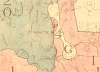
| Black Rock and the hill opposite it were glowingly described in late 1800’s travel commentaries as the “twin sentinels” to the eastern entrance of the Middlesex Fells. The other hill in these travelogues, and on early maps, is identified as White Rock. White Rock is shown on the modern-day Middlesex Fells trail map, but its nearby Melrose Rock that is listed by the USGS. |
| The three remaining USGS-listed hills in Melrose are High Rock, Pine Banks and Pine Hill. All three have connections to the earliest settlers in the “Mistic Syde” (Mystic Side) area of colonial Charlestown. High Rock, located in the north west corner of Melrose near the Stoneham and Wakefield borders, was in the past called Vintons Hill. John Vinton and his wife Ann are recorded living in Lynn in 1649.10 One of their sons, John, born 1650, worked as a “forgeman” likely at the Iron Works in Saugus. He married Hannah Green in 1677. She was the daughter of Thomas and Rebecca Green, of Malden (Rebecca’s father Joseph Hill was the person who selected Malden as the name for the town).11 John and Hannah would move to Woburn, but descendants of the Vintons and Greens would become prominent citizens and major land owners in Malden, Melrose, and Stoneham through the 1700s and 1800s. Several generations later, in 1771, Thomas Vinton would marry Mary Green, and later that same year, his brother Ezra Vinton would marry Mary’s sister, Sarah Green. The two couples, and Timothy Vinton, would live side-by-side at base of was then called Vinton Hill. The location of the hill is based on geological surveys. Not so for Pine Banks and Pine Hill. |
|
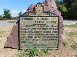
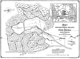
The USGS lists two Pine Banks, a summit and a park. The location of Pine Banks Park is based on geological surveys. The source of the location of Pine Banks hill is identified as an 1871 Topographical Atlas of Massachusetts. Pine Banks is not shown in that atlas, and the USGS coordinates given for the hill place the summit at same location in the official Pine Banks trail map as Mount Ephraim. The hill and park have a unique history. Since the land was first granted to Thomas Lynde in 1639, ownership of the land remained in one family until the 1880s.12 Lynde immigrated with his wife and two sons in 1634, settling in Charlestown. He became a deacon in the church and was elected selectman. His occupation was a malster, the person who produces malt from barley which is used in the. production of beer. As a prominent citizen, he was granted the land in Mystic Side that included Pine Banks. In 1670, it would be son, also named Thomas, who built was is thought to be the first house on land that would become Melrose. The land remained owned by descendants of the Lynde family until the 1880s when it was bought by a company looking to build a new factory. |
| In the early 1880s, Elisha S. Converse and his Boston Rubber Shoe Company, on track to become the worlds largest manufacturer of rubber boots and shoes, was looking for a second location for a factory near there Malden facility.13 Starting from a humble background, Elisa has worked on a farm, then in a clothing business before moving to Boston in 1844 to work with his elder brother James W. Converse and his uncles in their shoe and leather business. In 1847, with a partner and financial help from his brother, he bought the William Barrett’s grinding and rolling mill in Stoneham to process drugs and spices. In 1851, he became one of the founders of the First Malden Bank. In 1853 Elisha was offered the position of treasurer of the Malden Manufacturing Company. It had bought the building, machinery, and business of the failed Edgeworth Rubber Company. |
|
It’s difficult to imagine a time now, with our non-slip toothbrush handles and memory foam beds, when rubber was brand new. In the early 1800s, the flexible waterproof substance from the Amazon rain forest promised to revolutionize both consumer and industrial products, with millions being invested in the “rubber boom.” Unfortunately, natural rubber melted in warm weather and froze in the cold, leading to the failure of business attempting to use the new substance. It was in locations around Boston that Charles Goodyear developed his vulcanization process that revolutionized the industry. The Roxbury Rubber Company in 1833 and 1834 had produced and sold large quantities of shoes and coats using a different process. In the succeeding summer, most melted and were returned, ultimately buried in a landfill. It was officials at the Roxbury Company that initially funded Goodyear, and it was in Woburn in 1839 that he made his momentous discovery, reportedly by accident when he dropped some uncured rubber onto a hot stove. It would be at a small factory in Springfield, Mass. in 1844 when Goodyear was confident enough in the development of the process that he would apply for a patent. |
|
For Elisha Converse in 1853, two considerations likely influenced his decision to work in an industry where so many companies had failed before. First, the company had access to the Goodyear patent based on its board of directors including, a personal friend and legal advisor to Charles Goodyear, and Nathaniel Hayward, the person who worked with Goodyear in Woburn, and who some think should be entitled to equal credit for the discoveries of the process to vulcanize rubber. Second, Elisha, and his brother James, knew the shoe business, and likely had a good idea how revolutionary their product would be. The name of the company was changed to the Boston Rubber Shoe Company in 1855, and Elisha took on the additional roles of buying and selling agent, and eventually general manager and president. By 1880 the company was well on its way to becoming the world’s largest manufacturer of rubber boots and shoes, and looking to build another factory. The area around Pine Banks was available and Elisha purchased it and built a new factory between the hills of Pine Banks and the Middlesex Fells. Pine Banks itself was initially laid out to be subdivided into individual lots, but that never happened. Elisha and his wife Mary had a large mansion in Malden, and initially used Pine Banks as an exclusive park, building several log cabin retreats. But by 1890, Elisha had opened the park to the public, and when he died in 1904, his will proposed a public park jointly run by Malden and Melrose. |
| For the citizens of Malden, Elisha Converse was a respected citizen and a notable philanthropist. He was elected Malden’s first mayor when it became a city in 1882. Earlier, he had been elected to the Massachusetts house of representatives, and then state senate. A tragic incident for the Converse family happened in 1863 when Harry Converse, Elisha’s and Mary’s first-born son was murdered while he was working as a cashier at his father’s bank. As a tribute to their son, Elisha purchased the land and paid for the design (by noted architect Henry R. Richardson), construction, and furnishing of the Malden Public Library. He also made substantial contributions for the establishment and construction of the Malden Hospital, City Hall, Historical Society, Home for Aged Persons, Day Nursery, a public school, and a Baptist Church. After a fire destroyed his factory is 1875, he constructed a reservoir and donated it to the town with that understanding that the water if needed could be used to fight another fire, today’s Fellsmere Park. |
| While Elisha’s brother James W. Converse had the title president of the Boston Rubber Shoe Company, it appears that he was more active in other endeavors.12 He still was president of the original Field Converse leather company, also founder, director and eventually president of the Mechanics Bank in Boston. A Deacon in the Baptist church, he was a major benefactor to the Tremont Temple Church in Boston with Converse Hall named for him. Elisha donated the organ in the hall. in 1850, James went to Grand Rapids, Mich. to straighten out a land ownership issue of the Baptist Mission. While there he noticed the significant gypsum deposits in the area used for stucco and plaster. He purchased large tracts of land for development, and gypsum mills. He then financed a railroad providing access to the area and established the Phoenix Furniture Company. Back in Boston, he and his son were trustees in the Boston Land Company and its efforts to develop the recently filled marshes in east Boston and Orient Heights. He was appointed receiver of the Hartford and Erie railroad, and made speculative investments in the Colorado Smelting Company. |
|
|
| Melrose Maps |
| • |
Melrose - Google Maps, Terrain |
| • |
Melrose - MassMapper MassGIS |
| • |
Melrose - USGS - The National Map |
| • |
Boston North Quadrangle - 2018 (60 MB PDF) - USGS Topo Download |
| • |
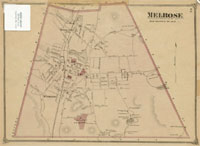
Atlas of the Town of Melrose, Middlesex County, George H. Walker & Co., 1899 - State Library of Massachusetts |
| • |
Melrose, 1875 - Lucius Beebe Memorial Library Historic Maps, Digital Commonwealth |
| • |
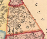
Map of Middlesex County, Mass., Henry F. Walling, 1856 - Library of Congress |
| • |
Maiddlesex Fells Reservation, C.J. Peters & Son, 1919 - Library of Congress |
| • |
Middlesex Fells Reservation Map (PDF) - Commonwealth of Massachusetts |
| • |
Middlesex Reservation Forest and Road Plan - Olmsted Archives, NHS, NPS |
| • |
Flora of the Middlesex Fells Reservation, Metropolitan Park Commission, 1896 - WikiMedia Commons |
| • |
Melrose Maps: 2, 3, 4, 5, 6, 7, Atlas of Middlesex County, Volume 2, published by Geo. W. Walker & Co., 1906 - State Library of Massachusetts |
| • |
Pine Banks Trail Map - Pine Banks Park |
| • |
MapJunction |
| • |
See: Hills of the Middlesex Fells Reservation |
|
|
| Melrose Sources |
| • |
The History of Melrose, County of Middlesex, Massachusetts, Elbridge H. Goss, 1902 - Internet Archive |
| • |
Ancient Melrose and some Information about its Old Homesteads, Families & Furnishings, Melrose Historical Society, 1915 - Internet Archive |
| • |
Melrose, Massachusetts, 1900-1950, Edwin C. Kemp, 1950 - HathiTrust |
| • |
The History of Malden, Massachusetts, 1633-1785, Deloraine P. Corey, 1899 - Internet Archive |
| • |
Melrose, History of Middlesex County, Massachusetts, with Biographical Sketches of Many of its Pioneers and Prominent Men, Duane Hurd, 1890, Vol. 3 - Internet Archive |
| • |
Melrose, History of Middlesex County, Massachusetts: Containing Carefully Prepared Histories of Every City and Town in the County, Samuel A. Drake, 1880, Vol. 2 - Internet Archive |
| • |
Echoes from Mystic Side: Malden, Melrose, Everett, Helen M. Hill , 1890 - HathiTrust |
| • |
Melrose, Images of America, Anthony J. Pagano, 1998 - Google ebook preview |
| • |
Melrose, Images of America, Vol. 2, Anthony J.Pagano, 1998 - Google ebook preview |
| • |
Melrose, MHC Reconnaissance Survey Town Report (PDF), 1981 - Massachusetts Historical Commission |
| • |
Melrose Open Space and Recreation Plan (PDF), 2015 - City of Melrose |
| • |
Melrose Open Space & Trails Pocket Guide (PDF), 2009 - City of Melrose |
| • |
See: Hills of the Middlesex Fells Reservation |
|
|
| Footnotes |
| 1 |
History of The Military Company of Massachusetts now called The Ancient and Honorable Artillery Company of Massachusetts, 1637-1888, pg. 220, 1898 - HathiTrust |
| 2 |
Immigrant Rev. John McLeish, Climbing My Family Tree, Part 11 A, 2017 - Alan deMeurers |
| 2 |
The Anatomy and Physiology of the Hair, William Bogle, 1846 - Google ebook |
| 4 |
Wendell P. Hood, Memorialia of the Class of '64 in Dartmouth College, John C. Webster, 1884 - Google ebook |
|
John Hood of Lynn, Massachusetts and Some of His Descendant, Mary J. H. Bosson, 1909 - Google ebbok |
|
Annual catalogue of Red Wing Collegiate Institute, 1872/73, 1873 - HathiTrust |
|
Red Wing Collegiate Institute, History of Goodhue County, Minnesota, pg. 291, Franklyn C. Wedge, 1909 - Google ebook |
| 5 |
John Charles Fremont Slayton, Biographical history of Massachusetts, Vol. 5, pg. 337, Samuel A. Eliot, 1914 - Google ebook |
| 6 |
Middlesex Fells - Boston Rocks! An exploration into the geology, land use and engineering of the Boston area |
|
Roadside Geology of Boston: The Medford Dike and the Breakup of Pangaea, 2015 - Written in Stone |
|
Middlesex Fells Reservation, 2015 - Dani McDonlad |
| 7 |
Thomas Coitmore, pg. 87, History of the Military Company of the Massachusettsn, Vol. 1, 1637-1738, 1895 - Internet Archive |
| |
The Governor's Lady, Why one of Malden's Public Parks is called "Coytmore Lea", pg. 13, Register of the Malden Historical Society. Vol. 6, 1919-1920 - HathiTrust |
| 8 |
Genealogy of the Odiorne Family, pg. 75, James C. Odiorne, 1875 - HathiTrust |
| |
Rockdale: The Growth of an American Village in the Early Industrial Revolution, pg. 208 , Anthony F.C. Wallace, 1972 - Google preview |
| 9 |
Petition of the stockholders of Spot Pond Aqueduct Company, 1845 - Internet Archive |
|
Corruption and Reform: Lessons from America's Economic History, pg. 163, Edward L. Glaeser, Claudia Goldin, 2006 - Google ebook preview |
|
The Lost Mill Village of Middlesex Fells, pg. 61, Douglas L. Heath, Alison C. Simcox, 2006 - Google ebook preview |
|
First A nnual Report of the Metropolitan Water Board, pg. 24, 1896 - HathiTrust |
|
Commonwealth of Massachusetts - Documentary History of American Water-works |
| 10 |
The Vinton Memorial, Comprising a Genealogy of the Descendants of John Vinton of Lynn, 1648, John A. Vinton, 1858 - Internet Archive |
| 11 |
A Genealogical Sketch of the Descendants of Thomas Green[e] of Malden, Mass., Samuel S. Greene, 1858 - Internet Archive |
| 12 |
Ancient Melrose, pg. 22 - Internet Archive |
|
Thomas Lynde - RootsWeb |
|
Deacon Thomas Lynde - Kristin C. Hall |
| 11 |
Elisha Slade Converse, pg. 173, Family record of Deacons James W. Converse and Elisha S. Converse, William G. Hill, 1887 - Internet Archive |
|
Malden Past and Present, Issued on the Occasion of the Two Hundred and Fiftieth Annivesary, Deloraine P. Corey, 1899 - HathiTrust |
|
Elisha Slade Converse, pg. 731, Men of Progress: One Thousand Biographical Sketches and Portraits of Leaders in Business and Professional Life in the Commonwealth of Massachusetts, Richard Herndon, Edwin M. Bacon, 1896 - Google ebook |
|
New England Manufacturers and Manufactories, Vol. 1, pg. 120, Edwin M. Bacon - Google ebook |
|
The Great Workshop: Boston's Victorian Age, pg. 143, Chaim M. Rosenberg, 2004 - Google ebook preview |
|
Making Rubber Work, Part 1, Part 2, Chuck Slaybaugh, 2012 - Rubber Plastics News |
|
The India-Rubber Industry in New England, PG. 334, The New England States, Vol. 1, William T. Davis, 1897 - Google ebook |
|
Running over waves: Mary Parker Converse, Inna Babitskaya, 2014 - Wicked Local Malden |
|
The Maiden Murder. Arrest of the Culprit Green, 1864 - New York Times |
|
Nathaniel Manley Hayward, pg. 560, Biographical Dictionary of American Business Leaders, Volume 2, John N. Ingham, 1983 - Google ebook preview |
| 12 |
James Wheaton Converse, pg. 161, Family record of Deacons James W. Converse and Elisha S. Converse, William G. Hill, 1887 - Internet Archive |
|
The Standard, Volume 47, pg. 12, 1900 - Google ebook |
|
History of the City of Grand Rapids, Michigan, Albert Baxter, 1891- HathiTrust |
|
What is the Converse Addition?, 2014 - Valley City |
|
Phoenix Furniture Co., 1872-1953 - Furniture City History, Grand Rapids Chamber of Commerce |
|
Tremont Temple Sketch Book, Rev. Geo. C. Lorimer, C.H. Blackall, 1896 - Internet Archive |
|
Plan of Orient Heights, Boston, H.T. Whitman, 1894 - Norman B. Leventhal Map Center, Boston Public Library |
| |
|
|
|