| Hills of Winchester, Mass. |
| | Hills | More about Winchester's USGS-listed hills | Maps | Sources | |
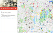
| Andrews Hill |
| • |
USGS identified - MassMapper MassGIS |
| • |
Google Maps | Google Earth - Google |
| • |
"...which lies level beneath the slopes of Andrews Hill, was one of these open, grassy areas...", Chapman, pg. 4, 1936 - Haithtrust |
| • |
Asa Locke House,"...After Asa Lockets death in 1857, Elbridge inherited it. It was sold to his sister Almira and her husband Hiram Andrews...." - Massachusetts Historical Commission Information System (MACRIS) |
| • |
"...which lies level beneath the slopes of Andrews Hill, was one of these open, grassy areas...", Chapman, pg. 4, 1936 - Haithtrust |
| • |
"...There was strong opposition by a minority, and the minority included most of the families on Indian
or Andrews Hill and along Cambridge Street in the western part of the town...", Chapman, pg. 164, 1936 - Haithtrust |
| • |
Andrews Hill - USGS Geographic Names Information System |
|
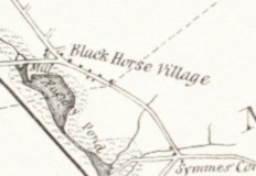
| Black Horse Hill |
| • |
Google Maps | Google Earth - Google |
| • |
"...The celebrated Black Horse Tavern was situated on this Great Road, on
Black Horse Hill...", Winchester Record, pg. 280, 1885 - Haithtrust |
| • |
Black Horse Village,"...A famous tavern known as the "Black Horse Tavern" stood at the north corner of Main Street and Black Horse Terrace from about 1728 until 1892. It was the only meeting place for the farmers of southern Woburn and northern Medford during Colonial times and it served as the mustering place for those who fought at Lexington, and soldiers in the Revolution...." - Massachusetts Historical Commission Information System (MACRIS) |
| • |
Black Horse Tavern Barn,"...The barn is the only remaining part of the Black Horse Tavern, an era with great significance in much of Winchester's past. For a time the town was even called Black Horse Village after the well-known tavern which provided a center for community life in the 18th and early 19th centuries...." - Massachusetts Historical Commission Information System (MACRIS) |
| • |
The Black Horse Tavern (PDF), Ellen Knight, 2018 - Town of Winchester |
|
| Grinding Rock Hill |
|
| Gypsy Moth Hill |
|
| Money Hill |
|
| Mount Pisgah |
| • |
USGS identified - MassMapper MassGIS |
| • |
Google Maps | Google Earth - Google |
| • |
"...Mount Pisgah. Bearing a Biblical name, this hill was acquired in 1903 by the town which built water standpipe on top in 1912 to provide water for the west side of town. It was abandoned in 1945...", Names of Places in Winchester - Town of Winchester, Massachusetts/Internet Archive | PDF - Town of Winchester, Massachusetts |
| • |
Mount Pisgah: "...The summit of Mt. Pisgah, about 350 feet, is the highest point in Winchester and in the winter, there is a view of the Boston skyline from some places on the hill. The stone walls and cedars suggest that this land was used as pasture in the early days of Winchester..." - Winchester Trails/Internet Archive |
| • |
"...Indian Hill. One of the Western Hills...", Names of Places in Winchester - Town of Winchester, Massachusetts/Internet Archive | PDF - Town of Winchester, Massachusetts |
| • |
"...Indian Hill, 1663, Location - westerly part of Winchesters, in Winchester Hill so called, one of the highest points there. ...", Cutter, pg. 8, 1892 - Internet Archive |
| • |
"...Indian Hill, 1663. Location – westerly part of Winchester, on Winchester Hill so called; one of the highest points there....", Woburn Historic Sites and Old Houses, pg. 8, William R. Cutter, 1892 - Internet Archive |
| • |
"...Andrews Hill. Now known as Mount Pisgah, this hill (like Andrews Road) was named for Hiram Andrews, a farmer who owned much of the land in the area in the early 19th century...", Names of Places in Winchester - Town of Winchester, Massachusetts/Internet Archive | PDF - Town of Winchester, Massachusetts |
| • |
"The Indian Hill referred to is in Winchester. On July 30, 1850, there was a conveyance from Ruth
Wyman to Gardner Symmmes of 18.5 acres of the 'Indian Hill pasture' in Winchester...", Hurd, pg 748, 1890 - Internet Archive |
| • |
Mount Pisgah - USGS Geographic Names Information System |
|
| Myopia Hill |
| • |
Google Maps | Google Earth - Google |
| • |
"...Myopia Hill . Overlooking the Mystic Lakes, this hill was named for the Myopia Club. The club originated with a group of boys who used to play together, at first around Wedge Pond, and who took on the name “Myopia” - since they were all near-sighted - in 1876 when they took up baseball...", Names of Places in Winchester - Town of Winchester, Massachusetts/Internet Archive | PDF - Town of Winchester, Massachusetts |
| • |
"...The singular but melodious name is the physician's word, derived from the Greek, for the affliction of near-sightedness; it is said to have been suggested to the club from the fact that most of its members had to wear glasses! Mr. Skillings became interested in the Myopia Club, and offered to build for it a clubhouse and stables on land belonging to him at the top of the hill overlooking Mystic Lake — the hill that has ever since been called Myopia Hill. ...", Chapman, pg. 225, 1936 - Haithtrust |
| • |
"...Everett Heights, This name was applied for a short time to Myopia Hill while Edward Everett owned land on either side of Cambridge Street. Everett (1794-1865) - former president of Harvard University, Governor of Massachusetts, U.S. Senator, Secretary of State, minister to Great Britain, candidate for vice-president, and orator at Gettysburg along with President Lincoln - purchased 16 acres of the original Squaw Sachem farm from the Wyman family in 1858. Everett Avenue was also named for him....", Names of Places in Winchester - Town of Winchester, Massachusetts/Internet Archive | PDF - Town of Winchester, Massachusetts |
|
| Nanepashemet Hill |
|
| Quigley Hill |
|
| Ridge Hill |
| • |
Google Maps location | Google Earth - Google |
| • |
"...Ridge Hill (near the site of the Unitarian Church) was the evident successor of Elbow Hill, and is remembered by persons now living, though the height itself has been levelled...", 250th Anniversary, pg. 12 - HathiTrust |
| • |
"...Elbow Hill a neighboring height of the former. Supposed to the height latterly called Ridge Hill, but now mostly dug down. The Winchester Unitarian Church edifice occupies a part of the spot...", Hurd, pg. 342, 1890 - Google ebook |
|
| Wedge Pond Hill |
|
|
|
 |
|
 |
|
Middlesex Fells
Reservation |
 |
|
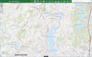
| Black Horse Hill |
 |
|
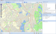
| Mount Pisgah |
 |
|
 |
|
 |
|
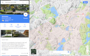
| Myopia Hill |
 |
|
|
|
| More about Winchester's USGS-listed hills |
|
Winchester is one of eight towns in the Boston Basin Hills survey area that were the last to become incorporated. Somerville would lead the way for this group splitting off from Charlestown in 1842. Everett would be the last splitting off from Malden in 1870. Winchester was settled by 1640 as part of Charlestown. It wouldn't be incorporated as a town until 1850. In early land grants the area was known as Waterfield for the abundance of marshes, lakes, and ponds next to the Aberjona River.1 The Native American term is thought to mean “junction or confluence” possibly describing the point the fresh water river joins the tidal Mystic River, its name likely derived from “misstuk” or “great tidal river.” In 1642, when Woburn split off from Charlestown, Winchester became South Woburn, or South Village. In the mid-1700s the area became known as known Black Horse Village,2 named for a tavern located in the town on a stage coach route. The Middlesex Canal was built through the town in 1803 connecting the manufacturing center of Lowell with Boston. In 1835 a railroad line would follow almost the same route through the town and before long make the canal obsolete. This was of the earliest railroad lines in the country and while initially used primarily for shipping freight, once the equipment and the service became reliable, passenger traffic increased rapidly. Reaching South Woburn became a quick train ride from Boston. |
|
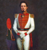
One Bostonian attracted to the South Woburn area by the railroad was Frederick O. Prince (1818-1899). Recently married, the wealthy Boston lawyer built a summer house on Wedge Pond in 1848. Interested in politics, he became involved with the local citizens' efforts to seperate from Woburn and become a separate town. When that eventually happened, Prince would become the town’s first member of the Massachusetts House, then a Senator, and finally mayor of Boston in 1877. Before that, in 1849 the problem was coming up with a name for the new town. It was over 200 years since immigrants would name their new town after one they had left in England. The first list of named considered was quite long including, Harmony, Linden, Alton, Winthrop, Wyoming, Mystic, Sheffield, South Woburn, Waterville and Columbus. Waterville and Columbus got the most votes from the committee, but a final decision was postponed. At that point Prince suggested that they name the town Winchester after his friend William P. Winchester (1801-1850) in hope that in recognition of the compliment he might give the town a gift of money.3 |
|
William P. Winchester was the scion of his father’s and uncle’s meat packing business. Edmund Winchester (1772-1839) had made a fortune provisioning the U.S. Navy with salted pork during the War of 1812. The company E.A.&W. Winchester (Edmund, his brother Amasa, and William) also used the byproducts of butchering to become a leading manufacturer of soaps and candles. William was one of richest men in Boston at the time and socialized with the elite. He and his wife Eliza Gill Bradlee (1802-1850) were given a townhouse to live in by her father in the exclusive Franklin Place designed by noted American architect, Charles Bulfinch. William enjoyed yacht racing and in 1839 had a schooner, Northern Light, built. Starting in 1845 he started buying land in Watertown (today part of Cambridge) along the Charles River where he had built a country mansion he called Fern Hill. When he told about the town adopting the Winchester family name, he was flattered and offered $3,000 for the town to spend as they needed. That’s a lot of money, worth about $100,000 today, but less than half what he had spent on his yacht, and really quite cheap for naming rights. In 1859, it’s not recorded how much China-merchant John P. Cushing paid, other than saying he contributed, to have the name of his estate Belmont selected for the town, but he did pay all the real estate taxes in the town for a year. Rattan factory-owner Cyrus Wakefield in 1867 was so pleased that South Reading was changing its name to Wakefield, he promised the town $100,000, worth today about $1.7 million. In Winchester’s defense, he didn’t live in the town, he had no businesses there, and he would, sadly, never visit dying of typhoid fever only months after the town was incorporated with his name. |
|
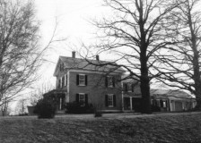
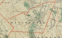
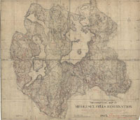
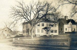
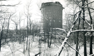
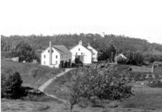
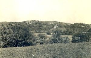
Winchester has three USGS-listed hills. Grinding Rock Hill (213 ft.) is located in the Middlesex Fells Reservation (see listing here). The other two hills are Andrews Hill (203 ft.) and Mount Pisgah (338 ft.). The USGS first identified and labeled both hills on the Boston sheet of their 1900 topographic map. Mount Pisgah is a name from the Bible referring to the mountain summit Moses reached to view the promised land. Not an uncommon name, there are several in Mount Pisgah’s in Massachusetts. In the Boston Basin Hills survey area, Prospect Hill in Somerville was called Mount Pisgah during the Revolutionary War by the British to taunt the Continental troops that they could see Boston but would never reach it. That proved false. Andrews Hill is recorded as being named for Hiram Andrews (1802-1881). Andrews is not old family name from either Winchester or Woburn, and Hiram was born in Essex, Mass., formerly the Chebacco section of Ipswich. Andrews is an old family name in Ipswich dating back to the 1630s.4 The coordinates given by the USGS for the summit of Andrews Hill provides a clue. The top of Andrews Hill is in the backyard of the Asa Locke House listed on the Massachusetts Cultural Resources Information System (MACRIS) database. Locke is an old family name in Winchester when it was South Woburn, and the description in the historical significance of the house links it to another old family name in Winchester, the Wymans. Asa Locke bought the land from Benjamin, Wyman a relative of Asa’s wife Lucy. Asa’s eldest son inherited the house and sold it to his sister, Almira Wyman Locke (1809-1888). She was the wife of Hiram Andrews. He married into two of the oldest families in Winchester. The hill probably should have been named for either the Locke or Wyman families, but possibly when the USGS were surveying the area, at that point in time it was owned by Hiram Andrews. |
|
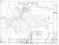
This would all be a simple solution for the naming of Andrews Hill except for the fact that the town of Winchester says the hill doesn’t exist and instead was the earlier name for Mount Pisgah. Andrews Hill is over a hundred feet shorter than Mount Pisgah and topographically more of spur of the higher summit, but the USGS will name a spur. A hill not listed by the USGS plays role in the confusion and is likely the original name for one or the other of the two USGS-listed hills. Edward Converse (1590-1663)5 is credited as the first settler of Winchester, and Woburn, in 1640. He built a house and a mill next to the Aberjona River near, it is thought, where the modern Converse bridge is located. The bridge you see today, and the unique stepped semi-circular Center Falls Dam and Mill Pond Park, was designed by landscape architect Herbert J. Kellaway (1867-1947) in 1914.6 After Converse died, and inventory was made of his estate and one item was, “Land on ye Indian Hill.” That would likely make Indian Hill the first named hill in both Winchester and Woburn. Unfortunately, it wasn’t recorded which hill he meant. Winchester Historical Society member George Cooke, in The Winchester Record of 1885, writes, “The ground designated is to be identified and reason to be explained.” Five years later the Historical Society must have found some information because in their publication on 250th Anniversary of the settlement of the town they write, “Indian Hill, now Andrews Hill.” Jump forward in time to 1912, and in both the Winchester Star and Boston Globe coverage of a new standpipe in Winchester, the location identified is on Indian Hill.7 Mount Pisgah had the standpipe, not Andrews Hill. The Winchester Archival Center has a 1915 map labeled Indian Hill and it shows land area west of Cambridge St. up to the summit of Mount Pisgah. It’s likely that the location of Edward Converse’s Indian Hill will never conclusively be known. |
|
|
| Winchester Maps |
| • |
Winchester - Google Maps, Terrain |
| • |
Winchester - MassMapper: MassGIS |
| • |
Winchester - USGS - The National Map |
| • |
Boston North Quadrangle - 2018 (60 MB PDF) - USGS Topo Download |
| • |
Lexington Quadrangle -: 2018 (60 MB PDF) - USGS Topo Download |
| • |
Town of Winchester, Middlesex County, Mass., Henry F. Walling, 1854 - Digital Commonwealth |
| • |
Map of the Town of Winchester Issued by the Winchester National Bank, 1939 - Chase Map Collection, Winchester Public Library |
| • |
Middlesex Fells Reservation, Prepared by C.J. Peters & Son Co., 1905 - Digital Commonwealth |
| • |
Winchester Maps: 26, 27, 28, 29, 30, 22, 23, 24, 25, Atlas of Middlesex County, Volume 2, published by Geo. W. Walker & Co., 1906 - State Library of Massachusetts |
| • |
Boston Sheet, Massachusetts. Topographical Survey Commission - Library of Congress, David Rumsey |
|
|
| Winchester Sources |
| • |
250th Anniversary of the First White Settlement Within the Territory of Winchester: July 4th, 1890, Winchester Historical Society, 1890 - HaithiTrust |
| • |
The Winchester Record, Winchester Historical and Genealogical Society, 1885-1887 - HaithiTrust |
| • |
Winchester, History of Middlesex County, Massachusetts, with Biographical Sketches of Many of its Pioneers and Prominent Men, Duane Hurd, 1890, Vol. 2 - Internet Archive |
| • |
Wincherster, History of Middlesex County, Massachusetts: Containing Carefully Prepared Histories of Every City and Town in the County, Samuel A. Drake, 1880, Vol. 2 - Internet Archive |
| • |
Woburn Historic Sites and Old Houses, William R. Cutter, 1892 - Internet Archive |
| • |
Family of Col. William P. Winchester, Winchester Notes, Fanny W. Hotchkiss, pg. 111, 1912 - HaithiTrust |
| • |
History of Winchester, Massachusetts, Henry S. Chapman, 1936 - HaithiTrust |
| • |
Winchester, Images of America, Frank H. Sleeper, 1995 - Google ebook preview |
| • |
Winchester Archives Online Catalog - Town of Winchester |
| • |
Archival Center - Town of Winchester |
| • |
Winchester Historical Scoiety |
| • |
Winchester, MHC Reconnaissance Survey Town Report (PDF), 1981 - Massachusetts Historical Commission |
| • |
Walks and Rides in the Country Round about Boston, Edwin M. Bacon, 1897 - Internet Archive |
|
|
| Footnotes |
| 1 |
Why Aberjona?, Sylvester Baxter, Madford Historical Register, pg. 57, 1919 - Google ebook |
|
Aberjona River Historicaal Background (PDF), Ellen Knight, 2016 - Town of Winchester |
| 2 |
New restaurant brings back memories of old Winchester, Ellen Knight, Feb. 1, 2010- Daily Times Chronicle |
| 3 |
Colonel Williiam P. Winchester, Winchester Historial Society - Winchester Community Acceess & Media, IMCOTEK Digital Films |
|
Lt. Col. William Parson Winchester (PDF), Ellen Knight - Town of Winchester |
|
Col. Winchester's 200th Birthday (PDF), Ellen Knight, Black Horse Bulletin, 2002 - Winchester Historical Society |
|
Historic American Yachts: Early Boston Vessels, the Northern Light and Coquette, Winfield M. Thompson, The Rudder, Vol. 15, pg. 387, 1904 - Google ebook |
| |
The Yacht "Northern Light" in Boston Harbor, F.H. Lane, 1845 - Fitz Henry Lane |
| |
My Winchester Family of Brookline, Annie B. Winchester, 1927 - Brookline Historical Society |
| 4 |
Lieutenant John Andrews of Chebacco, Massachusetts, 1637-1708, Henry F. Andrews, 1909 - Internet Archive |
| |
Book of the Lockes. A Genealogical and Historical Record of the Descendants of William Locke of Woburn, John G. Locke, pg. 136, 1853 - Google ebook, Internet Archive |
| 5 |
An Inventory of the Estate lately possessed by Edward Convers, The Winchester Record, Vol. 1, pg. 58, 1885 - HathiTrust |
|
Our Aborigines, George Cooke, The Winchester Record, Vol. 1, pg. 275, 1885 - HathiTrust |
| 6 |
Herbert J. Kellaway: Linking Water, Parks and Parkways in the Olmsted Tradition, Julie Khuen, 1995 - Winchester Historical Society |
| 7 |
Newsy Paragraphs, Winchester Star, Oct. 23, 1903, pg. 8, Winchester Public Libraries - Internet Archive |
| |
Winchester, Boston Globe, Sep. 7, 1912, pg. 3 - Boston Globe (subscription) |
|
|