| Hills of Chelsea, Mass. |
| | Hills | More about Chelsea's USGS-listed hills | Maps | Sources | |
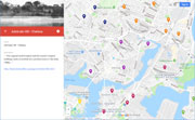
| Admirals Hill |
| • |
Google Maps | Google Earth - Google |
| • |
"...Admirals Hill sits atop a point of land between the Mystic River and Island End River...On the south slope of the hill is the site of the historic Chelsea Naval Hospital....", Chelsea Open Space and Recreation Plan 2010-2016 (PDF), pg. 26, 2010 - City of Chelsea |
| • |
Naval Hospital Boston Historic District (Chelsea Naval Hospital), "...The original naval hospital and the marine hospital buildings were converted into condominiums in the early 1980s...." - National Park Service |
| • |
"...On Government hill are the United States Marine and the United States Naval hospitals.....", Gillespie, 1898, Pg. 33 - Hathitrust |
| • |
"...The northerly side of the Government Hill has been reduced to form the plateau for the Marine Hospital....", Chamberlain, 1908, Pg. 2 - Internet Archive |
| • |
"...From the salt marshes the surface of the town rises to four considerable drumlins which dominate the town: Mts. Washington and Bellingham, Powder Horn Hill (the
highest, at 230 feet), and Nasal Hosptal Hill..", pg. 1, Chelsea, MHC Reconnaissance Survey Town Report (PDF), 1980 - Massachusetts Historical Commission |
| • |
Naval Hospital Boston Historic District (Chelsea Naval Hospital) National Park Service |
| • |
"...The northerly side of the Government Hill has been reduced to form the plateau for the Marine Hospital....", Chamberlain, 1908, Pg. 2 - Internet Archive |
| • |
"..A Captain Morton who had recently arrived in Chelsea reported that he had heard the British were considering taking Green’s Hill in Chelsea, slightly west of the Winnisimmet Ferry... ", Katie T. Getty, The House at Penny Ferry, Burnt: Skirmishes on the Mystic, 2018 - Journal of the American Revolution |
|
| Mill Hill |
| • |
USGS identified - MassMapper MassGIS |
| • |
Google Maps | Google Earth - Google |
| • |
Chelsea, Mass., "...A smaller drumlin (Mill Hill) is located on the east side of Chelsea, adjacent to Mill Creek.. .....", - Wikipedia |
| • |
Slade's Mill History, "...1721-1734 The mill was built as a tidal-powered grist mill. 1735-1827 Various owners. 1827 Henry Slade acquired a share of the mill and began to grind snuff as well as corn. 1837 Slade’s sons, David and Levi, joined the business and started to grind spices.. .....", - Slade's Mill Apartments |
| • |
"The Story of the old Slade Spice Mill in Chelsea, "...In 1734, Thomas Pratt at his own expense, built a tide-water mill, originally known as "The Mill," the forerunner of Slade's Mill..." - Slade Genealogy |
| • |
Slade Spice Mill, "..The first structure constructed on this site, c.1734, was a grist mill. The location was intrinsic to the operation of the mill by providing the tide, which supplied the mill with power...
...In 1775 a naval engagement was fought just downstream from the mill and resulted in one of the earliest naval victories of the Revolution. The presence of the dam prevented the British warships from proceeding up the Mill Creek, which would have put them in firing range of Chelsea... " - Massachusetts Historical Commission Information System (MACRIS) |
| • |
The Colonial Slade Mill - Foundation of a Spice Empire - New England Historical Society |
| • |
Tidal Power in Colonial Boston - The West End Museum |
| • |
Ensign Thomas Pratt, Cutter, pg. 1576, Vol. 3, 1908 - Internet Archive |
| • |
Mill Hill - USGS Geographic Names Information System |
|
| Mount Bellingham |
| • |
USGS identified - MassMapper MassGIS |
| • |
Google Maps | Google Earth - Google |
| • |
Bellingham Hill Park - City of Chelsea |
| • |
Governor Richard Bellingham (1592-1672), "...Bellingham lived in a town house on what is now Tremont Street in Boston...During the summer months, he also spent time in a home believed to have been near the Ferry on Marginal Street, Chelsea. In 1635, he purchased large tracts of land from Samuel Maverick and John Blackleach in the still largely unsettled area around Powder Horn Hill in Rumney Marsh and Winnisimmet, now Chelsea..." - Governor Bellingham-Cary House Association |
| • |
"...Richard Bellingham, for thirteen years deputy governor of Massachusetts and ten years its governor, was once the owner of all Chelsea. His name still clings to one of our highest hills and to one of our most beautiful streets...", Gillespie, 1898, Pg. 33 - Hathitrust |
| • |
Who Were the Real Founders of Boston? "...two years after Maverick had sold the premises to Richard Bellingham, afterward governor..." - Samuel Maverick Blog |
| • |
Governor Richard Bellingham, "...The major portion of these holdings, including the purchase from Maverick were in what is now Chelsea. He attempted an unusual arrangement with his land. In the English manorial fashion, he divided the land into four parts and leased each portion to a tenant farmer...", History of the Town of Bellinhgam, 1660-1780, Bruce W. Lord - Town of Bellingham, Mass. |
| • |
Gov. Bellingham-Cary House, " - Massachusetts Historical Commission Information System (MACRIS) |
| • |
"...[Bellingham] left behind him as his final self-assertion a last will and testament that was to torment legal minds for a century to come. The contest over this memorable will had no parallel in the country, and by tying up the property it effectively retarded the development of early Chelsea...", Chelsea, City of Transformation, pg. 205, Massachusetts, A Guide to its Places and People, WPA Federal Writers' Project, 1937 - HathiTrust |
| • |
Mount Bellingham - USGS Geographic Names Information System |
|
| Powder Horn Hill |
| • |
USGS identified - MassMapper MassGIS |
| • |
Google Maps | Google Earth - Google |
| • |
"...The name of Powderhorn Hill has been the subject of much discussion, and its origin is not definitely known. One of the traditions is that it was once sold for a horn of powder, but this cannot be traced to an authentic source. Another theory is that its shape was considered as resembling a powder horn...", Gillespie, 1898, Pg. 10 - Hathitrust |
| • |
"...Powderhorn Hill, which tradition says was once sold for a horn of powder. The top of this hill, which was purchased by the city in 1897, is set aside to be enjoyed forever as a public park. From the top of this hill during the Revolution signals were made to the people in Roxbury and Cambridge, giving the news of any movements of the British army in Boston. During the winter of 1775-6 three companies of Colonial troops had their quarters on the south side of this hill...", Pratt, pg. 26, 1908 - Internet Archive |
| • |
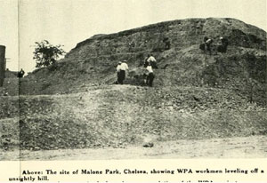
Malone Park - Powderhorn Hill - Massachusetts Historical Commission Information System (MACRIS) |
| • |
Malone Park, "...Powderhorn Hill at the Soldiers' Home..." - City of Chelsea |
| • |
Powder Horn Hill - USGS Geographic Names Information System |
|
|
|
 |
|
 |
|
| Admirals Hill |
 |
|
| Mount Bellingham |
 |
|
 |
|
| Powder Horn Hill |
 |
|
 |
|
 |
|
|
|
| More about Chelsea's USGS-listed hills |
|
In 1630 when John Winthrop sailed into Boston harbor at the beginning the Puritan migration, he found three small groups of people already living there. One of them was led by Samuel Maverick (c.1602-c.1670). He had built a house, one of the first in the Massachusetts Bay, on the side of Admirals Hill in Chelsea possibly as early as 1624. The area wasn’t called Chelsea at the time, that wouldn’t happen until 1739 when Chelsea was incorporated as a town. The Native Americans called the area Winnisimmet, thought to mean "at the good spring."1 Maverick and the two others Winthrop found living in the area, William Blaxton (1595-1675) at Shawmut (today’s downtown Boston) and Thomas Walford (c.1599-1666) at Mishawum (today’s Charlestown), are thought to members of earlier English settlement efforts that failed, and they stayed in the area. Unlike the Puritans, all three were Episcopalians and supporters of the Church of England. That did not bode well for their relations with the ever-increasing numbers of Puritans arriving, not known for their tolerance of other religions. The Puritans would hang a Quaker in 1660. All three would provide help that was indispensable to the survival of the new colony but all three would be effectively banished from the Boston area. In 1631 Walford, a blacksmith, and his wife would leave for Strawberry Bank (in today’s Portsmouth, N.H.). The area, while still legally under the Massachusetts Bay land grant, had become home for a number of people who dissented from the strict rule Puritan rule. Blaxton, an Episcopalian minister, would become the first European settler in Rhode Island after he left Boston in 1635. Maverick would stay until 1648, then leave for England where he attempted enlist the support of the government in breaking the Puritans stranglehold on Boston. His efforts were unsuccessful and later became a merchant in Dutch-controlled New Amsterdam, today’s New York City. |
| Admirals Hill is not a USGS listed hill, and the name only dates to the early 1980s when the former Chelsea Naval Hospital was converted to condominiums. The hospital itself was opened in the 1836, that lead to the hill being called Naval Hospital Hill and Government Hill. An early name, Greens Hill, dates to the Revolutionary War. Jonathan Green (1719-1795) had moved from Stoneham to Chelsea in 1772 and built a house on the hill. The Battle of Bunker Hill took place directly across the Mystic River from his home. That summer the British staged two raids up the Mystic River as far as Malden burning a ferry house. There was fear that the British would attack Chelsea. That never happened, and shortly after the war Green returned to Stoneham. Though not before filing a claim lost property, crops, and livestock damaged and lost to plundering groups of soldiers from both sides. |
|
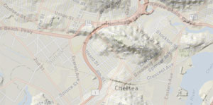
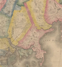
USGS-listed Power Horn Hill (161 ft.) is one earliest named hills in the Boston Basin. In the same year, 1632, that John Winthrop was naming Mount Feake in Waltham for his son-in-law, the General Court ordered that “the necke of land betwixte Powder Horne Hill and Pullen Poynte shall belonge to Boston to be enjoyed by the inhabitants thereof forever.”2 One tradition is that the hill got its name because it was bought from the Native Americas for a horn of gunpowder. This seems highly unlikely. For Puritans in 1632 trade with the Native Americans was restricted, and no Native Americans could carry firearms.3 It is much more likely Powder Horn Hill got its name from its shape. Filling, leveling, road cuts, and development make it difficult to imagine the outline of the hill as viewed from town of Winnisimmet in 1630. The 1867 NOAA Nautical Map shows how much of modern-day Chelsea, even at that much later date, was marsh land. Leaving the town Winnisimmet in the 1600s on the road to Salem, the hill ahead of you would sweep in a long arc to your left, much like the shape of a common powder horn. |
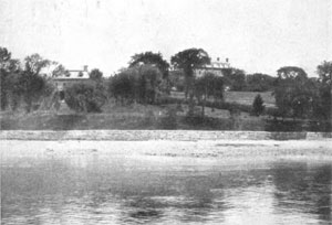
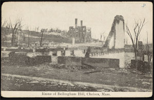
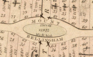
| USGS listed Mount Bellingham (108 ft.) is named for Richard Bellingham (c.1592-1672)4 In 1635 he purchased most of Winnisimmet from Samuel Maverick. While not as well-known a colonial figure as John Winthrop, Richard Bellingham was one of the original investors in the Massachusetts Bay Colony, served as governor of Massachusetts, in total, ten years, thirteen years as deputy governor, and held multiple other prominent positions. He also repeatedly clashed with Winthrop on political matters. People remember Winthrop for his statement, "We shall be as a city upon a hill, the eyes of all people are upon us." They don’t remember he also said that democracy was “the meanest and worst of all forms of government.” It was Bellingham, not Winthrop who pushed for the Massachusetts Body of Liberties, one of the earliest protections of individual rights in America. And it was Bellingham and not Winthrop who wanted to enact laws to increase religious tolerance. Bellingham lived in Boston and used the former Maverick house in Winnisimmet as a summer retreat. He also built a hunting lodge at the base of Powder Horn Hill in 1659. If the function of these buildings is true, they must have been one the earliest summer houses and hunting lodges built in New England. Samuel Cary converted and expanded the lodge in 1791 and it still stands today. Neither of these buildings are near USGS-listed Mount Bellingham (108 ft.). Bellingham Street runs across the hill and Bellingham Hill Park is near its summit. The hill is part of development effort in the 1830s and was likely given its name at the time. |
| USGS listed Mill Hill (62 ft.) is named for the site of a grist mill built by Thomas Pratt (1699-1780) in 1734, one of the earliest tidal mills in Massachusetts. The Pratts were early settlers in the area and many generations have held prominent positions in Chelsea, so much so that there is a section of the city called Prattville. Though the mill is not located there. Rebuilt multiple times after fires, it is known today as the Slade Spice Mill. Henry Slade (1791-1868) began grinding corn and snuff there in 1827. His sons David (1819-1912) and Levi (1822-1884) took over the business and starting grinding spices in 1837. |
|
|
| Chelsea Maps |
| • |
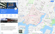
Chelsea - Google Maps, Terrain |
| • |
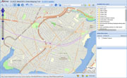
Chelsea - MassMapper MassGIS |
| • |
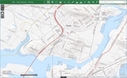
Chelsea - USGS - The National Map |
| • |
Boston North Quadrangle - 2018 (60 MB PDF) - USGS Topo Download |
| • |
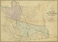
Map of Chelsea, Mass., 1867 - Norman B. Leventhal Map Center, Boston Public Library |
| • |
Chelsea Maps: 1, 2, 3, 4, 5, 6, 7, 8, 9, 10, 11, Atlas of The City of Chelsea and the Towns of Revere & Winthrop, G.W. Bromley & Co., 1914 - State Library of Massachusetts |
| • |
Atlas of the boundaries of the city of Chelsea, Suffolk County, 1898 - State Library of Massachusetts |
|
|
| Chelsea Sources |
| • |
A Documentary History of Chelsea: including the Boston Precincts of Winnisimmet, Rumney Marsh, and Pullen Point, 1624-1824, Vol. 1, Vol. 2, Mellen Chamberlain, 1908 - Internet Archive |
| • |
The Chelsea Gazette, Souvenir Edition, Charles B. Gillespie, 1898 - Hathitrust |
| • |
The Burning of Chelsea, Walter M. Pratt, 1908 - Internet Archive |
| • |
Chelsea, Edison Electric Illuminating Co., 1909 - Internet Archive |
| • |
Chelsea, Images of Amercia, Margaret H. Clarke, 1998 - Google ebook preview |
| • |
Chelsea, Postcard History Series, Gerard W. Brown, 2004 - Google ebook preview |
| • |
Chelsea Open Space and Recreation Plan 2010-2016 (PDF), 2010 - City of Chelsea |
| • |
Public Improvements for the Metropolitan District, Massachusetts. Metropolitan Improvements Commission, 1909 - Internet Archive |
| • |
Chelsea, MHC Reconnaissance Survey Town Report (PDF), 1980 - Massachusetts Historical Commission |
| • |
Genealogical and Personal Memoirs Relating to the Famlies of Boston and Eastern Massachusetts, Volumes 1-3, William R. Cutter, 1908 - Internet Archive |
|
|
| Footnotes |
| 1 |
Dictionary of American-Indian Place and Proper Names in New England, pg. 179, R. A. Douglas-Lithgow, 1909 - Internet Archive |
| 2 |
Records of the Court of Assistants of the Colony of the Massachusetts Bay, 1630-1692, pg. 29, County of Suffolk, 1904 - Google ebook |
| 3 |
Armed America: The Remarkable Story of How and Why Guns Became as American as Apple Pie, pg. 43 , 20006 - Google ebook preview |
| 4 |
Governor Richard Bellingham, History of the Town of Bellinhgam, 1660-1780, Bruce W. Lord - Town of Bellingham, Mass. |
|
|