| Hills of the Middlesex Fells Reservation, Mass. |
| | Introduction | Hills | Maps | Sources | |
| "At the midpoint of the 19th century commerce was on the move in New England, as elsewhere. Expanding cities and towns were swallowing up available land at a rapid rate. The impact on forests and water resources was immense, as rivers and streams were dammed, and land cleared and subdivided at an increasing rate. Towns and cities were densely packed and increasingly polluted." |
| "How the pristine area now known as the Middlesex Fells, the Blue Hills, and the vast network of greater metropolitan green space was saved from the destructive forces of the march of history is testament to the foresight, dedication and generosity of a group of remarkably practical visionaries. Their efforts fostered a great movement that has allowed us to live in an area graced with natural beauty and
spaciousness." Read all > > |
|
| Hills of the Middlesex Fells Reservation, Mass. |
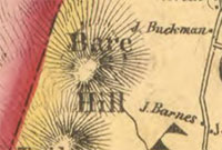
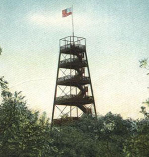
| Bear Hill - Stoneham |
| • |
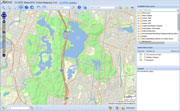
USGS identified - MassMapper MassGIS |
| • |
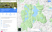
Google Maps | Google Earth - Google |
| • |
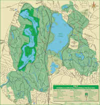
Middlesex Fells Reservation Map (PDF), DCR, 2017 - Commonwealth of Massachusetts |
| • |
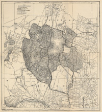
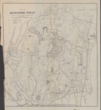
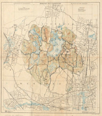
Topographical Map of Middlesex Fells Reservation, Franch, Bryant & Taylor, Metropolitan Park Commission,1895 - Norman B. Leventhal Map Center, Boston Public Library |
| • |
"...From thence (towards the N.W. about half a mile,) they came to the top of a very high rock, beneath which, (towards the N.) lies a goodly plain, part open land, and part woody, from whence there is a fair prospect, but it being then close and rainy, they could see but a small distance. This place they called Cheese Rock, because, when they went to eat somewhat, they had only cheese, (the governor's man forgetting, for haste, to put up some bread)...., Robert C. Winthrop, Life and letters of John Winthrop, Vol. 2, pg. 104, 1867 - HathiTrust |
| • |
"...To us they handed down;"Cheese Rock" they named that lovely hill,
Those men of high renown.
Some smaller men cut off the trees.
And then they named it " Bare";
And when the bushes wildly grew,
The spelled it "B-e-a-r."....", The Legend of "Cheese Rock", Forest Festival, June 17, 1882, The Medford Historical Register, Vol. 14, pg. 103, 1911 - HathiTrust |
| • |
"...This place they called Cheese Rock, because, when they went to eat somewhat, they had only cheese, (the governor's man forgetting, for haste, to put up some bread)...",Winthrop's Journal, "History of New England" 1630-1649, pg. 74, James K. Hosmer, 1946 - HathiTrust |
| • |
"...to Bear Hill (320 feet). This is the highest point in the Fells, and embraces Governor Winthrop's historic Cheese Rock, distant about two miles by the carriage-road from Winchester station...." - Bacon, pg. 56, 1897 - Internet Archive |
| • |
"...During the year 1620 if a white man could have stood upon the summit of Bear Hill a grand and lovely view would have stretched out before him..." - Hurd, pg. 461, 1890 - Internet Archive |
| • |
"...This pit lies north from what is now called Bear Hill. This was formely called Bears Hill, from the fact of its having been a noted place for the residence of those animals. Gov. Winthrop states in his history of Massachusetts, that he was travelling this way on a certain occasion, and stopped upon Bears Hill, to rest and
refresh himself with food. On examining for his provisions it seems his servant forgot to put up anything but some cheese, from which circumstance he called Bear Hill Cheese Rock...", Dean, pg. 21, 1870 - HathiTrust |
| • |
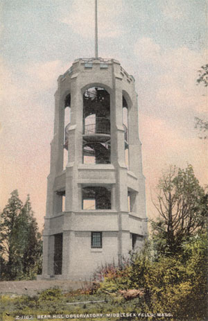
"...Bare Hill Obervatory. This station is situated on Bare hill, in the southwestern part of Stoneham, about 1'4 of a mile south of Marble street, on land belonging to the Metropolitan park system. It is a square frame stru cture, built of hard or yellow pine. The triangulation point is marked by a copper tack enclosed in a triangle in the northeasterly corner of the upper floor...", Atlas of the boundaries of the town of Stoneham, Middlesex County<, Sheet 3, 1899 - State Library of Massachusetts |
| • |
"...From Spot Pond, Governor Winthrop and his party went to what is now called Bear Hill. This is the highest elevation in the Pells, being about 370 feet above sea-level, and is distant from the State House exactly 7-3/4 miles.... " - Lawrence, pg. 205, 1886 - Internet Archive |
| • |
"...So first stop was Bear Hill in The Fells where the historic Cheese Rock (so named by early Massachusetts Governor John Winthrop) was reportedly located. Generally, it is thought to be Bear Hill, or a ledge of that hill, overlooking to the north/northwest. However, one old book has a picture of it being an isolated boulder. That boulder was not uncovered on my trip, and I move on to the south..." - The Return, Jim Moore, 2015 - Memoirs of a Rolling Stone |
| • |
Bear Hill, - USGS Geographic Names Information System
Variant name: Bare Hill |
|
| Black Rock - Melrose |
| • |
USGS identified - MassMapper MassGIS |
| • |
Google Maps | Google Earth - Google |
| • |
Middlesex Fells Reservation Map (PDF), DCR, 2017 - Commonwealth of Massachusetts |
| • |
Topographical Map of Middlesex Fells Reservation, Franch, Bryant & Taylor, Metropolitan Park Commission,1895 - Norman B. Leventhal Map Center, Boston Public Library |
| • |
"...In 1640, Thomas Coytmore, quite often spelled Coitmore, who became a freeman in that year, and who was one of the Deputies to the General Court from Charlestown, in 1640 and 1641, built first a dam, and then a mill at Black Rock, on Three Myle Brook..." - Ancient Melrose, pg. 29, 1915 - Internet Archive |
| • |
"...Between the summits of Black Rock and White Rock, the charming Cascade, previously described, comes tumbling down from the top of these rocks, during each spring and autumn....." - Goss, pg. 224, 1902 - Internet Archive |
| • |
Black Rock - USGS Geographic Names Information System |
|
| Boojum Rock - Malden |
| • |
USGS identified - MassMapper MassGIS |
| • |
Google Maps | Google Earth - Google |
| • |
Middlesex Fells Reservation Map (PDF), DCR, 2017 - Commonwealth of Massachusetts |
| • |
Topographical Map of Middlesex Fells Reservation, Franch, Bryant & Taylor, Metropolitan Park Commission,1895 - Norman B. Leventhal Map Center, Boston Public Library |
| • |
"... Its northern extremity has been christened "Boojum Rock." The story is that on approaching this elevation, it suddenly disappears from view, and then as suddenly re-appears, without any apparent reason for so strange an action; but this is, of course, purely imaginary, and dependent on the particular point of view from which one approaches it...", Davenport, pg. 15, 1893 - Internet Archive |
| • |
Boojum, "...fictional creature in 'The Hunting of the Snark' (1876), a narrative nonsense poem by Lewis Carroll. In the poem, the elusive Snark turns out to be a mysterious monster called a Boojum... " - Encyclopædia Britannica |
| • |
Middlesex Fells Reservation Map (PDF) - Commonwealth of Massachusetts |
| • |
Boojum Rock - USGS Geographic Names Information System |
|
| Cairn Hill - Stoneham |
| • |
Google Maps | Google Earth - Google |
| • |
Middlesex Fells Reservation, Gorden H. Taylor, Olmsted and Eliot, 1895 - Norman B. Leventhal Map Center, Boston Public Library |
| • |
Map of the towns of Wakefield, Stoneham, Reading, North Reading, and Lynnfield, H.T. Whitman, 1907 Norman B. Leventhal Map Center, Boston Public Library |
|
| Deer Hill - Stoneham |
| • |
Google Maps | Google Earth - Google |
| • |
Middlesex Fells Reservation Map (PDF), DCR, 2017 - Commonwealth of Massachusetts |
| • |
Topographical Map of Middlesex Fells Reservation, Franch, Bryant & Taylor, Metropolitan Park Commission,1895 - Norman B. Leventhal Map Center, Boston Public Library |
| • |
"...electric railway line follows route from Main Street between Winthrop and Deer Hills with original roadbed and concrete bridge still intact from early 1900s...." , Stoneham, MHC Reconnaissance Survey Town Report (PDF), 1981 - Massachusetts Historical Commission |
|
| Ellen Hill |
| • |
"...View of the south west side of Ellen Hill, showing the birches which have come to occupy the old pasture land...", Job #1513, Fells (Middlesex) Reservation, A.A. Shurtleff, 1898 - Frederick L. Olmsted Archives NHS, NPS |
|
| Flagstaff Hill - Medford |
|
| Gerry Hill - Medford |
| • |
USGS identified - MassMapper MassGIS |
| • |
Google Maps | Google Earth - Google |
| • |
Middlesex Fells Reservation Map (PDF), DCR, 2017 - Commonwealth of Massachusetts |
| • |
Topographical Map of Middlesex Fells Reservation, Franch, Bryant & Taylor, Metropolitan Park Commission,1895 - Norman B. Leventhal Map Center, Boston Public Library |
| • |
Perhaps: Ira Gerry (1806-1875), "...Ira Gerry, the youngest son of Captain David and Sarah Richardson Gerry, was born in Stoneham June 29, 1806, and was a descendant in the fifth generation from the original settler, Thomas Gerry...He was a large owner and dealer in real estate, inheriting from his father land which afterwards became some of the
most valuable of the town. Like his brother, Col. Elbridge Gerry, he was an ardent sportsman, and from his gun and dog derived through life the greater part of his recreation", Hurd, vol.3, pg. 498, 1890 - Internet Archive |
| • |
Perhaps: Elbridge Gerry, (1744-1814) Member of the U.S. House of Representatives from Massachusetts's 3rd district. 9th Governor of Massachusetts, 5th Vice President of the United States - Wikipedia |
| • |
Gerry Hill - USGS Geographic Names Information System |
|
| Grinding Rock Hill - Winchester |
|
| Little Pine Hill - Medford |
|
| Melrose Rock - Melrose |
|
| MIT Geodetic Observatory - Malden |
| • |
Google Maps | Google Earth - Google |
| • |
Middlesex Fells Reservation Map (PDF), DCR, 2017 - Commonwealth of Massachusetts |
| • |
"...The occasion is the completion of a geodetic observatory at Middlesex Fells, where instruction is now given in astronomical observations such as will prepare students for the career of observer in geodetic work...", The Geodetic Observatory at Middlesex Fells, George L. Hosmer, Technology Quarterly and Proceedings of the Society of Arts, Vol. 12, pg. 135, 1899 - Google ebook |
| • |
MIT’s Mysterious Observatory Rediscovered, "...The 15 square foot stone observatory was built in 1899 by MIT to research geodesy, the study and measurement of the earth’s shape. Very few hikers have actually found the observatory, which lies at a high point within the Fells’ 2,575 acres and more than 20 miles of hiking trails..." - Slice of MIT |
| • |
Uncovering the MIT Geodetic Observatory in the Middlesex Fells, "...The hill that the observatory sits on is arguably the highest point in the Malden area, allowing the research and observation conducted there to have a large periphery of vision...." - Friends of the Middlesex Fells Reservation |
|
| Money Hill - Winchester |
| • |
Google Maps | Google Earth - Google |
| • |
Middlesex Fells Reservation Map (PDF), DCR, 2017 - Commonwealth of Massachusetts |
| • |
Topographical Map of Middlesex Fells Reservation, Franch, Bryant & Taylor, Metropolitan Park Commission,1895 - Norman B. Leventhal Map Center, Boston Public Library |
| • |
"...Money Hill is said to owe its name to the custom, during the days of the gypsy moth epidemic, of paying off the workers at that point...", The Medford historical Register, vol. 38., pg. 71, 1898 - Internet Archive |
|
| Nanepashemet Hill - Winchester |
| • |
Google Maps | Google Earth - Google |
| • |
Middlesex Fells Reservation Map (PDF), DCR, 2017 - Commonwealth of Massachusetts |
| • |
Topographical Map of Middlesex Fells Reservation, Franch, Bryant & Taylor, Metropolitan Park Commission,1895 - Norman B. Leventhal Map Center, Boston Public Library |
| • |
Nanepashemet, "...Nanepashemet (died 1619) was the leader, or Great Sachem, of the Pawtucket Confederation of Abenaki peoples in present-day New England before the landing of the Pilgrims. He ruled over a large part of what is now coastal Northeastern Massachusetts..." - Wikipedia |
|
| 90mm Site - Medford |
| • |
Google Maps | Google Earth - Google |
| • |
Middlesex Fells Reservation Map (PDF), DCR, 2017 - Commonwealth of Massachusetts |
| • |
"...Cold War AAA Defenses of Boston: Several permanent sites were established for the Army's Anti-Aircraft Artillery (AAA) Gun Site Program, the precursor to the NIKE missile defense program. Four 90mm AA guns were positioned at each site, with troop barracks and other support buildings. Known sites include: Medford (1952 - 1958): at Middle Fells Park...", Boston Harbor II - North American Forts |
|
| Old Man of the Fells |
| • |
"..a short-distance from Forest street and the new boulevard is a rare combination of the natural and the artificial, or rather accidental, an object of interest and one rarely seen, the 'Old Man of the Fells'....", Medford Historical Society Papers, Vol. 15, pg. 23, 1912 - Internet Archive |
|
| Pasture Hill - Fells Reservation - Medford |
|
| Pickerel Rock - Stoneham |
|
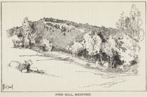
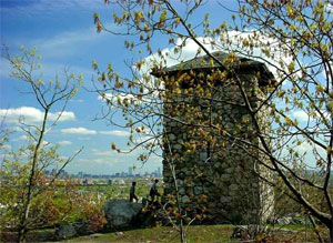
| Pine Hill - Medford |
| • |
USGS identified - MassMapper MassGIS |
| • |
Google Maps | Google Earth - Google |
| • |
Middlesex Fells Reservation Map (PDF), DCR, 2017 - Commonwealth of Massachusetts |
| • |
Topographical Map of Middlesex Fells Reservation, Franch, Bryant & Taylor, Metropolitan Park Commission,1895 - Norman B. Leventhal Map Center, Boston Public Library |
| • |
"...Pine Hill is the most elevated of the many small elevations in Medford. It is in the northerly part of the City, and about one mile from the Square. Forest Street runs close by its easterly slope. It commands a fine view from its east, south and west sides.....", Hooper, pg. 12, 1906 - Internet Archive |
| • |
History of Middlesex Fells: "...Wright's Tower (located on Pine Hill), paid for by Elizur Wright's family to commemorate his work for the Fells, was built by the WPA....", - Friends of the Fells |
| • |
Pine Hill - USGS Geographic Names Information System |
|
| Pinnacle Rock - Malden |
|
| Quigley Hill - Winchester |
|
| Rams Head Hill - Medford |
| • |
Google Maps | Google Earth - Google |
| • |
Middlesex Fells Reservation Map (PDF), DCR, 2017 - Commonwealth of Massachusetts |
| • |
A Midwinter Ramble, "...Farther up, the brook is crossed by the road leading from Forest street to Ram's Head hill. Here is a rustic bridge, and for some distance the declivity is but slight, and the stream broadens and lingers in the shady groves.....", Medford Historical Society Papers, Vol. 22 - Persus Digital Library |
| • |
The towers of Medford, "...But higher and more remote is the great steel tower on the so-called Ram-head hill, erected by the late General S. C. Lawrence, and commonly called the Lawrence Observatory. The top of this hill is variously stated as being two hundred and five or two hundred and twenty-nine feet above sea level....", Medford Historical Society Papers, Vol. 24 - Persus Digital Library |
|
| Rock Hill - Fells Reservation - Medford |
|
| Saddleback Hill - Stoneham |
|
| Silver Mine Hill - Medford |
|
| Taylor Mountain - Stoneham |
| • |
USGS identified - MassMapper MassGIS |
| • |
Google Maps | Google Earth - Google |
| • |
"...Taylor Mountain might well be called the southern end of Bear Hill, being part of the same mass. From this so-called mountain we have a charming bit of scenery..." - Lawrence, pg. 206, 1886 - Internet Archive |
| • |
Taylor Mountain - USGS Geographic Names Information System |
|
| Wamoset Hill - Stoneham |
| • |
USGS identified - MassMapper MassGIS |
| • |
Google Maps | Google Earth - Google |
| • |
Topographical Map of Middlesex Fells Reservation, Franch, Bryant & Taylor, Metropolitan Park Commission,1895 - Norman B. Leventhal Map Center, Boston Public Library |
| • |
"...Colonists who encountered “the people” in their permanent winter village of Wamesit (Wah me sit) in what is now Lowell at the junction of the Merrimack and Concord rivers...called them the Wamesit after the name of their village of around 2,500 acres. Wamesit (also Wamoset) was said to mean “Here is space for all”, referring to all the people who otherwise lived on the coastal saltmarshes..." - What do our Algonquian place names really mean?, Mary Ellen Lepionka, 2018 - Native Americans of Cape Ann |
| • |
"...Wamoset, a variant of the wamesit, Algonquian meaning perhaps 'there is room for all'...." - Native American Placenames of the United States, William Bright, pg. 544, 2004 - Google ebook preview |
| • |
"...and then proceed onward through the sag between Wamoset Hill and Whip Hill...." - Bacon, pg. 64, 1897 - Internet Archive |
| • |
Wamoset Hill - USGS Geographic Names Information System |
|
| Wanapanaquin Hill - Stoneham |
| • |
USGS identified - MassMapper MassGIS |
| • |
Google Maps | Google Earth - Google |
| • |
Topographical Map of Middlesex Fells Reservation, Franch, Bryant & Taylor, Metropolitan Park Commission,1895 - Norman B. Leventhal Map Center, Boston Public Library |
| |
"...Wenepoykin was taken prisoner in the Wampanoag war, in 1676, and died in 1684. He married Ahawayet, daughter of Poquanum, who lived on Nahant.She presented him with one son, Manatahqua, and three daughters, Petagunsk, Wattaquattinusk, and Petagoonaquah...They were called Wanapanaquin, or the plumed ones. This word is but another spelling of Wenepoykin, their father's name, which signifies a wing, or a feather. I suppose they were
the belles of the forest, in their day, and wore finer plumes than any of their tribe...", History of Lynn, Essex County, Massachusetts, including Lynnfield, Saugus, Swampscott, and Nahant, pg. 39, Alonzo Lewis, James R. Newhall, 1865 - Internet Archive |
| • |
"...Wanapanaquin, a name applied to the three daughters of Winepoykin, and means 'The plumed ones'..." - Dictionary of American-Indian place and proper names in New England, Robert A. Douglas-Lithgow, pg. 361 , 1909 - Google ebook preview |
| • |
Wanapanaquin Hill - USGS Geographic Names Information System |
|
| Wenepoykin Hill - Medford |
| • |
Google Maps | Google Earth - Google |
| • |
Middlesex Fells Reservation Map (PDF), DCR, 2017 - Commonwealth of Massachusetts |
| • |
Topographical Map of Middlesex Fells Reservation, Franch, Bryant & Taylor, Metropolitan Park Commission,1895 - Norman B. Leventhal Map Center, Boston Public Library |
| • |
Wenepoykin, "...Born in 1616, Wenepoykin was the youngest son of Nanapashemet and Squaw Sachem. At a very young age he was installed as Sachem of Naumkeag, or in the present-day areas of Danvers, Andover, and south to Spot Pond...." - The Menotomy Journal |
|
| Whip Hill - Stoneham |
| • |
USGS identified - MassMapper MassGIS |
| • |
Google Maps | Google Earth - Google |
| • |
Middlesex Fells Reservation Map (PDF), DCR, 2017 - Commonwealth of Massachusetts |
| • |
Topographical Map of Middlesex Fells Reservation, French, Bryant & Taylor, Metropolitan Park Commission,1895 - Norman B. Leventhal Map Center, Boston Public Library |
| • |
"...and then proceed onward through the sag between Wamoset Hill and Whip Hill..." - Bacon, pg. 64, 1897 - Internet Archive |
| • |
Whip Hill Park: "...The Whip Hill estate was built in the 1930's by James and Angie Crockett and was used a a family residence until 1968 when it was presented to the Town of Stoneham by Mrs. Crockett as a memorial to her husband..." - Town of Stoneham, Massachusetts |
| • |
Whip Hill - USGS Geographic Names Information System |
|
| White Rock - Melrose |
| • |
Google Maps | Google Earth - Google |
| • |
Middlesex Fells Reservation Map (PDF), DCR, 2017 - Commonwealth of Massachusetts |
| • |
Topographical Map of Middlesex Fells Reservation, Franch, Bryant & Taylor, Metropolitan Park Commission,1895 - Norman B. Leventhal Map Center, Boston Public Library |
| • |
"...Between the summits of Black Rock and White Rock, the charming Cascade, previously described, comes tumbling down from the top of these rocks, during each spring and autumn....." - Goss, pg. 224, 1902 - Internet Archive |
| • |
"...This is a natural entrance, between two bold elevations - Black Rock (243 feet) and White Rock, of a nearly equal altitude - the *' Twin Sentinels," as they have been called, - rising abruptly above the valley on either side of the steep and narrow passage thick with trees; and is to be made only by foot passers....." - Bacon, pg. 48, 1897 - Internet Archive |
| • |
Middlesex Reservation Forest and Road Plan, Sec. C-5 - Olmsted Archives, NHS, NPS |
|
| Winthrop Hill - Stoneham |
|
|
|
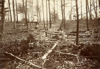
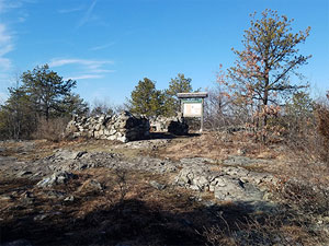
| Bear Hill |
 |
|
 |
|
 |
|
| Deer Hill |
 |
|
| Ellen Hill |
 |
|
| Geodetic Observatory |
 |
|
| Old Man of the Fells |
 |
|
| Pasture Hill (Fells) |
 |
|
| Pickerl Rock |
 |
|
| Pine Hill |
 |
|
 |
|
 |
|
| Pinnacle Rock |
 |
|
| Rams Head Hill |
 |
|
| Wenepoykin Hill |
 |
|
| |
| |
| |
|
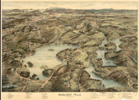
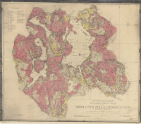
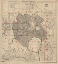
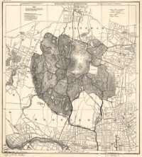
| Middlesex Fells Reservation Maps |
| • |
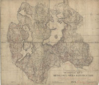
Map of the Middlesex Fells, Rosewell B. Lawrence, Appalachian Mountain Club, 1886 - Havard Library | Googe ebook |
| • |
Topographical Map of Middlesex Fells Reservation, French, Bryant & Taylor, Metropolitan Park Commission,1895 - Norman B. Leventhal Map Center, Boston Public Library |
| • |
Middlesex Fells Reservation, Gorden H. Taylor, Olmsted and Eliot, 1895 - Norman B. Leventhal Map Center, Boston Public Library |
| • |
Flora of the Middlesex Fells Reservation, Metropolitan Park Commission, 1896 - WikiMedia Commons |
| • |
Middlesex Fells, Geo. H. Walker & Co., c 1903 - Library of Congress |
| |
Preliminary Forest Plan of Middlesex Fells Reservation, Job #1513,1905 - Frederick L. Olmsted Archives NHS, NPS |
| |
Middlesex Fells Reservation Forest and Road Plans, Job #1513, 1905 - Frederick L. Olmsted Archives NHS, NPS |
| • |
Map of the towns of Wakefield, Stoneham, Reading, North Reading, and Lynnfield, H.T. Whitman, 1907 Norman B. Leventhal Map Center, Boston Public Library |
| • |
Maiddlesex Fells Reservation, C.J. Peters & Son, 1919 - Library of Congress |
| • |
Map of Middlesex Fells Reservation, Commonwealth of Massachusetts, Metropolitan District Commission, Parks Divisio, 1928 - State Library of Massachusetts |
| • |
The Original FellsBiker Trail Map of the Middlesex Fells Reservation, 2004 - FellsBiker.com |
| • |
Middlesex Fells Reservation Map (PDF), DCR, 2017 - Commonwealth of Massachusetts |
|
|
| Middlesex Fells Reservation Sources |
| • |
A Forest Preserve - A Proposal to State and City Governments, Wilson Flagg, Magazine of Horticulture, Botany, and All Useful Discoveries and Improvements in Rural Affairs, Vol. 22, pg. 11, 1856 - Google ebook |
| • |
The Voice of a tree from the Middlesex Fells, Elizur Wright, 1883 - HathiTrust |
| • |
Middlesex Fells, Appalachia. Vol. 4, Appalachian Mountain Club, Rosewell B. Lawrence, 1886 - Internet Archive / Havard Library / Google ebook |
| • |
Elizur Wright's appeals for the Middlesex Fells, Ellen Wright, 1893 - HathiTrust |
| • |
A Lecture on the Middlesex Fells, George E. Davenport, 1893 - Internet Archive |
| • |
The Middlesex Fells, Boston Park Guide: Including the Municipal and Metropolitan Systems of Greater Boston, Sylvester Baxter, 1896 - Internet Archive |
| • |
Notes on the New Public Forests Near Boston, Charles Eliot, Proceedings of the American Forestry Association, Vol. 40, pg. 114, 1896 - Google ebook |
| • |
Vegetation and scenery in the metropolitan reservations of Boston, Charles Eliot, 1897 - HathiTrust |
| • |
Middlesex Fells, Walks and rides in the country round about Boston, pg. 47, Edwin M. Bacon, 1897 - Internet Archive |
| • |
The Middlesex Fells, William B. de las Casas, Bay State Monthly, pg. 701, 1898 - Googe ebook |
| • |
Charles Eliot, Landscape Architect, Charles W. Eliot, 1902 - HathiTrust |
| • |
The Development of Middlesex Fells, Frederick W. Coburn, New England Magazine, pg. 813, 1910 - Googe ebook |
| • |
Job #1513, Fells (Middlesex) Reservation - Olmsted Archives, NHS, NPS |
| • |
The Middlesex Fells: The Case for a Resource Management & Maintenance Plan (PDF), Vanessa Bittermann, Ryan Christenberry, Sean Sylver, Abby Yenco, Tufts University Department of Urban and Environmental Policy and Planning (UEP), 2006 - Tufts University |
| • |
You can't always get what you want: Managing recreational use in the Middlesex Fells, Andrea L. Christenson, Massachusetts Institute of Technology. Dept. of Urban Studies and Planning, 2011 - DSpace@MIT |
| • |
Resource Management Plan, Middlesex Fells Planning Unit (PDF), 2012 - Massachusetts Department of Conservation and Recreation (DCR) |
| • |
The Middlesex Fells, a Flourishing Urban Foreset (PDF), Arnoldia, Walter Kittridge, 2013 - The Arnold Aboretum, Harvard University |
| • |
History of the Fells, Mike Ryan, 2014 - Friends of the Middlesex Reservation |
| • |
The Sachems of Massachusetts Bay (PDF), Ellen Knight, 2018 - Town of Winchester |
| • |
The Impact of Preserving the Middlesex Fells, pg. 65, The Boston & Maine and Malden: The Railroad's Impact on the Development of Malden's West End
Neighborhood, 1845-1900, Rebecca Solo, 2017 - Harvard DAHS |
| • |
Middlesex Fells: Images of America, Alison C. Simcox, Douglas L. Heath, 2015 - Google ebook preview |
|
MACRIS, Massachusetts Cultural Resource Information System |
| • |
Malden: Middlesex Fells Reservation Parkways - MACRIS |
| • |
Medford: Middlesex Fells Reservation - MACRIS |
| • |
Medford: Middlesex Fells Reservation Parkways - MACRIS |
| • |
Stoneham: Middlesex Fells Reservoirs Historic District - MACRIS |
| • |
Stoneham: Middlesex Fells Reservoir and Gatehouse - MACRIS |
| • |
Stoneham: Middlesex Fells Reservation Parkways - MACRIS |
| • |
Winchester: Middlesex Fells Reservation Parkways - MACRIS |
| • |
Atlas of the boundaries of the town of Stoneham, Middlesex County, 1899 - State Library of Massachusetts |
| • |
Middlesex Fells: Images of America, Douglas L. Heath, Alison C. Simcox, 2015 - Google ebook preview |
| • |
The Lost Mill Village of Middlesex Fells, Douglas L. Heath, Alison C. Simcox, 2017 - Google ebook preview |
| • |
Friends of the Middlesex Fells Reservation |
|
|
| |
|
_BHL40352842.jpg)