| The peninsula that would become Charlestown was called Mishawum (Great neck) by the Native Americans. It was first settled by Thomas and Jane Walford in 1623. The town incorporated in 1630, and was named after the English King Charles I. The original territory of Charlestown included what is now Melrose and Malden (both until 1649), Stoneham (until 1725), Somerville (until 1842), Medford, Everett, Woburn, Burlington, and parts of Arlington and Cambridge. Charlestown became a city in 1848, and was annexed by Boston in 1874. |
|
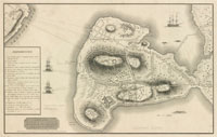
| Hills of Charlestown - Boston, Mass. |
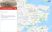
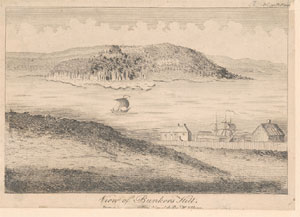
| Breeds Hill |
| • |
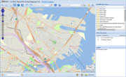
USGS identified - MassMapper MassGIS |
| • |
Google Maps | Google Earth - Google |
| • |
Breed's Hill - Wikipedia |
| • |
Battle of "Bunker Hill", "..That the hill was named for the Breed pastures south of the redoubt, which were owned by Ebenezer Breed, the great-grandson of John Breed, who was the second child of that family name born on American Soil, and the fourth son of the father of all the Breeds in America..." - Breed Family Record |
| • |
"...Not so with 'Breed's Hill,' for it is not named in any description of streets previous to 1775, and appears to have been called after the owners of the pastures into which it was divided, rather than by the common name of Breed's Hill...This hill is called Green's Hill in a British description of the town in 1775...:", Frothingham, pg. 325, 1845 - Internet Archive |
| • |
Colonel William Prescott, "..After marching from Cambridge he gathered his field officers at the top of Bunker Hill. They decided to build the fortification on Breed's Hill (un-named at that time, but part of it was known as Breed's pasture)..." - Celebrate Boston |
| • |
Breeds Hill - USGS Geographic Names Information System |
|
| Bunker Hill |
|
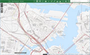
| Mortons Hill |
| • |
Google Maps | Google Earth - Google |
| • |
"...The purchase made by the United States was originally called Moulton's Point, from Robert Moulton, the ship-carpenter; it has also been indifferently styled Moreton's and Morton's Point, in connection with accounts of the battle of Bunker Hill, it being the place where Howe's main body landed on that day.....", Historic Fields and Mansions of Middlesex, pg. 27, 1874 - Internet Archive |
| • |
Charlestown Public Housing Projects (PDF), "...Two of the three original hills, Bunker Hill and Breed’s Hill remain today, but Morton’s Hill has disappeared. Similar to Beacon Hill in Boston, Morton’s Hill was probably leveled to expand Charlestown’s land area....", Julie Proulx, 2006 - DSpace@MIT |
|
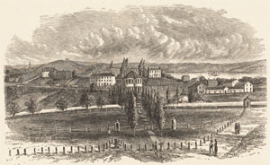
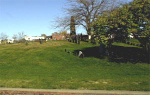
| School Hill |
|
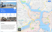
| Town Hill |
| • |
Google Maps | Google Earth - Google |
| • |
Full Historic Timeline, "...Thomas Graves builds a fort with “palisadoes and flankers” atop Fort Hill (now Town Hill) for protection from the Indians...." - Charlestown Historical Socirty |
| • |
"...The Town Hill was then called the 'Windmill Hill,' from the mill that Robert Hawkins built upon it in 1635. For a century,
estates in this vicinity, are described in deeds, as being on or near 'the Windmill Hill.' In a few years (1646) it was determined that this Hill 'should lie common to the town forever;' and that 'no more gravel should be digged or fetched from it.' Large quantities of gravel were carried from this Hill about the year 1782, when it was much higher than it now is. It must have been very much higher at the time of the settlement of the town.....", Frothingham, Pg. 94, 1845 - Internet Archive |
| • |
Town Hill District, "...Town Hill was laid out by Charlestown engineer Thomas Graves in 1629 and was the site of Boston's first settlement. The unique elliptical street plan forms a tightly delineated neighborhood that survives to this day, one of the few colonial aspects to have survived...." - Wikipedia |
|
|
|
|
| Charlestown Maps |
| • |
Charlestown - Google Maps, Terrain |
| • |
Charlestown - MassMapper MassGIS |
| • |
Charlestown - USGS - The National Map |
| • |
Boston North Quadrangle - 2018 (60 MB PDF) - USGS Topo Download |
| • |
Boston South Quadrangle - 2018 (60 MB PDF) - USGS Topo Download |
| • |
Array of American Forces on the Field at the Battle of Breeds Hill, Charlies E. Frye, 2011 - Wikipedia |
| • |
The attack on Bunker Hill in the peninsula of Charlestown the 17th of June 1775, Mildred G. Burrage, 1926 - Norman B. Leventhal Map Center, Boston Public Library |
| • |
Sketch of the Battle of Bunker Hill, George G. Smith, 1843 - Norman B. Leventhal Map Center, Boston Public Library |
| • |
A Plan of the Battle, on Bunkers Hill, R. Sayer & J. Bennett, 1775 - Massachusetts Historical Society |
| • |
A Plan of the Battle, on Bunkers Hill, S. Biggs, 1775 - Massachusetts Historical Society |
| • |
Plan of the peninsula of Charles Town shewing the three posts that His Majesty's troops have kept and fortified with buildings therein for guard rooms, John Montrésor, 1775 - Library of Congress |
| • |
Plan of the heights of Charles Town, Richard Williams, 1775 - Library of Congress |
| • |
Battle of Bunker Hill, 1775 - Library of Congress |
| • |
Rough draft of Charlestown, in water colour, 1775 - Library of Congress |
| • |
Plan of the action which happen'd 17th. June 1775, at Charles Town, N. America, Thomas H. Page, 1775 - Library of Congress |
|
|
| Charlestown Sources |
| • |
The History of Charlestown, Massachusetts, Richard Frothingham, Jr., 1845 - Internet Archive |
| • |
The Genealogies and Estates of Charlestown, Vol. 1 (A-J), Vol. 2 (K-Z), Thomas B. Wyman, 1879 - Internet Archive |
| • |
Charlestown, Boston 200 Neighborhood History Series, 1976 - Internet Archive |
|
|
|