| Hills of Weymouth, Mass. |
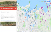
| | Hills | More about Weymouth's USGS-listed hills | Maps | Sources | |
| Brandy Hill |
| • |
Google Maps | Google Earth - Google |
| • |
"...Names and Nicknames - Brandy Hill, Madison Street...", Joy, Vol. 1, pg. 301 , 1923 - HathiTrust |
| • |
"...This locality was called Brandy Hill, though what gave it the name I never knew...", Joy, Vol. 2, pg. 918, 1923 - HathiTrust |
|
| Eastern Neck |
|
| Ferry Point |
| • |
USGS identified - Oliver MassGIS Online Mapping Tool |
| • |
Google Maps | Google Earth - Google |
| • |
"...Between Old Spain and Quincy Point, or Wessagusset and Mount Wollaston as they then were called, a ferry was authorized as earlv as 1635, and the rate of ferriage was fixed at a penny for each person and at threepence for each horse...", Adams, pg. 44, 1874 - HathiTrust |
| • |
"...As early as 1635 there was a ferry between Weymouth and Wollaston...", Joy, Vol. 1, pg. 301, 1923 - HathiTrust |
| • |
Ferry Point (Cape) - USGS Geographic Names Information System |
|
| Fort Point |
|
| Gravel Hill |
| • |
Google Maps | Google Earth - Google |
| • |
"...About 1859 the first church was built in a place called 'Gravel Hill' which is now St. Francis Cemetery...", Kevett, pg. 155, 1981 - Internet Archive |
|
| Great Esker Park |
|
| Hardings Hill |
| • |
Google Maps | Google Earth - Google |
| • |
"...Names and Nicknames - Harding's Hill, off Sea Street...", Joy, Vol. 1, pg. 301 , 1923 - HathiTrust |
| • |
"...John Harding was made a freeman of the Massachusetts Bay Colony, 13 May, 1640. He early settled in Weymouth...", Joy, Vol. 3, pg.254, 1923 - HathiTrust |
|
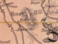
| Honey Hill |
| • |
Google Maps | Google Earth - Google |
| • |
"...Names and Nicknames - Honey Hill, south of Broad Street, Weymouth Landing...", Joy, Vol. 1, pg. 301 , 1923 - HathiTrust |
| • |
"...His father, in his will dated 9 Feb. 1740, bequeathed 'my son Ephraim Pratt shall have that piece of land that he has fenced in at the north end of his land at the place called Honey Hill, there being a steep ledge of Rocks which will serve the making a considerable deal of fence, that ledge of Rocks to be his bounds'...", Joy, Vol. 4, pg. 513 , 1923 - HathiTrust |
|
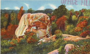
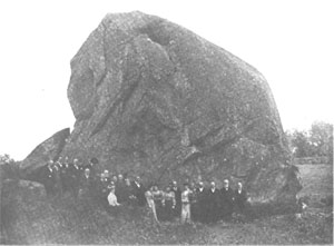
| House Rock |
| • |
Google Maps | Google Earth - Google |
| • |
"...It is now House Rock, Queen Rock and Sphinx Rock. Geology tells us that it is not native to Weymouth, but is a great boulder which had been brought where it is by the great mass of ice that moved over Weymouth in what may be called a 'glacial age,' and was dumped where it now
is when the ice was melting...", Joy, Vol. 2, pg. 120, 1923 - HathiTrust |
| • |
"...the Watching Rock, as the Indians called it. This is a great boulder as big as a very large house, and looking at it from a certain position there is the profile of a woman's face...", Joy, Vol. 1, pg. 119, 1923 - HathiTrust |
| • |
"..Several years ago a son of Mr. John J. Loud was taking some views of the rock with a camera. One of these views happened to get the profile of the face, and this led to the discovery of the profile, and it was found that the face was like that of Queen Victoria, so the rock has become still more famous. It is now House Rock, Queen Rock and Sphinx Rock...", Joy, Vol. 1, pg. 120, 1923 - HathiTrust |
|
| Hunt Hill Point |
| • |
USGS identified - Oliver MassGIS Online Mapping Tool |
| • |
Google Maps | Google Earth - Google |
| • |
Manuscript Map of the Town of Weymouth, circa 1800 - Massachusetts Historical Society |
| • |
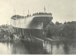
"...the two-masted schooner 'Clara B. Kennard', built at Weymouth in 1886, was wrecked at old Fort Point, on the same beach where she was launched at Hunt's Hill... Edmund S. Hunt, a well-known Weymouth manufacturer, developed a life saving cannon and projectile for reaching shipwrecks...", Weymouth Weymouth 350th Anniversary Booklet (PDF), Weymouth Historic Preservation - Town of Weymouth |
| • |
"...Onward moved the boats "Charity" and "Swan," passing Rose Hill and at last reaching the point of land afterward known as Hunt's Hill. Around the hook of this hill into the cove or bay, later called King's Cove...", Joy, Vol. 1, pg. 111, 1923 - HathiTrust |
| • |
Weymouth Ways and Weymouth People, Reminiscences, Edmund S. Hunt, 1907 - Internet Archive |
| • |
Hunt Hill Point (Cape) - USGS Geographic Names Information System
Variant name: Hunts Hill |
|
| Idlewell |
| • |
Google Maps | Google Earth - Google |
| • |
"...In the distance is the railroad cut at White's Neck where the quartz veins are to be found; to the right of the cut is the hill now known as Idlewell, probably a kame...", Joy, Vol. 1, pg. 152, 1923 - HathiTrust |
|
| Iron Hill |
|
| King Oak Hill |
| • |
USGS identified - Oliver MassGIS Online Mapping Tool |
| • |
Google Maps | Google Earth - Google |
| • |
"...John King, for instance, came to Wessagusset in the 'Charity' in 1622. In 1623 he went to the fishing station on the coast of Maine. From there he went back to England, and later returned to Wessagusset, but this time his wife Mary was with him. He had ten acres of land adjoining land of Joseph Shaw. This land was
bounded by the sea and included King's Cove, named after him...He also had land on King Oak Hill and in other parts of Weymouth...", Joy, Vol. 1, pg. 48, 1923 - HathiTrust |
| • |
King Oak Hill Park, "...The Emery Estate is a 24-acre property located on King Oak Hill in East Weymouth. The property was owned by the Emery family and operated as a single-family home (and at times, a working farm) for nearly 100 years..." - Town of Weymouth |
| • |
Binnian, William - Emery, Allan C. House,"...The Binnian House is a two and one half story Georgian Revival style residence modelled after George Washington's 'Mt. Vernon' mansion. Rectangular in plan, the house sits high on King Oak Hill...In 1916, after the death of firs. Binnian, the house and furnishings were sold to Allan C. Emery. Emery, who was active in the wool business, added approximately 10 acres tothe property...." - Massachusetts Historical Commission Information System (MACRIS) |
| • |
King Oak Hill - USGS Geographic Names Information System |
|
| Locust Hill |
| • |
"...The South Shore Railroad Company are hereby authorized to commence their railroad at some convenient point on the Old Colony Railroad, in the town of Quincy or Braintree, and to continue the same through the towns of Braintree and Weymouth, by Weymouth Landing and East Weymouth, and north of Locust Hill in North Weymouth...", Joy, Vol. 1, pg. 468, 1923 - HathiTrust |
|
| Louds Hill |
| • |
Google Maps | Google Earth - Google |
| • |
"...In front of this house, on the other side of Commercial Street, there stretches another hill which in those early days was covered with trees, and down in the valley to the south of the hill there was a pond which has since been called Cranberry Pond. From this a little stream runs through the meadows, and in the time of Morton it emptied itself into the river. The hill has since been called Loud's Hill...", Joy, Vol. 1, pg. 121, 1923 - HathiTrust |
| • |
"...Francis Loud appeared at Weymouth as early as 1722..", Chamberlain, Vol. 3, pg. 373, 1923 - HathiTrust |
|
| Low Hill |
|
| Lower Neck |
|
| Lower Neck (Historic) |
|
| Monatiquot Bluffs |
| • |
"...At that section of the shore known as Monatiquot Bluffs the greater part of the cottages have been become all the-year-round residents...", Weymouth Gazette, July 18, 1919, Weymouth Public Libraries - Internet Archive
|
|
| Pine Point |
| • |
USGS identified - Oliver MassGIS Online Mapping Tool |
| • |
Google Maps | Google Earth - Google |
| • |
"...they came to the point of land already mentioned as being called Lovell's Grove, named after a member of the Lovell family who had land in the vicinity. This place was noted for its trees, and in one part there was a beautiful grove of pine trees. In later years Lovell's Grove became a great resort for picnics and pleasure parties, and at one time was one of the most charming resorts in the harbor...at the north side of the grove, and at that point on the north side of the street was built the Pine Point Hotel which kept in memory the pine grove...", Joy, Vol. 1, pg. 117, 1923 - HathiTrust |
| • |
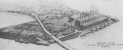
"...The Weymouth Light & Power Company is reported to have purchased the old Pine Point hotel property on the Weymouth side of the Quincy Point bridge on which it proposes to erect a large power plant...", Electrical World, Volume 57, pg. 263, 1911 - Google ebook |
| • |
Pine Point (Cape) - USGS Geographic Names Information System |
|
| Pratts Hill |
| • |
"...Names and Nicknames - Pratt's Hill, later known as the Mountain, Commercial Street, East Weymouth...", Joy, Vol. 1, pg. 301, 1923 - HathiTrust |
| • |
"...The name of Pratt occurs upon the records oi Wymouth more frequently than that of any other name, and the family has had from the early settlement a larger membership than any other family, and at the present day it counts its numbers among the largest...", The Pratt Family, A Genealogical Record of Mathew Pratt of Weymouth, Mass., Gilbert Nash, 1890 - HathiTrust |
|
| Richmond hill |
| • |
Google Maps | Google Earth - Google |
| • |
"...Richmond Hill, off Richmond...", Joy, Vol. 1, pg. 298, 1923 - HathiTrust |
| • |
"...The old Indian trails became the foundation for the roads in Weymouth. The hill over which we had just come was later called Mount Pleasant and Richmond Hill...", Joy, Vol. 1, pg. 122, 1923 - HathiTrust |
| • |
"...About the year 1820 Micah Richmond, a currier by trade, owned a large tract of land on the turnpike, now called Washington Street...and extending back on Richmond Hill, so called...", Joy, Vol. 1, pg. 318, 1923 - HathiTrust |
|
| Rose Cliff |
| • |
USGS identified - Oliver MassGIS Online Mapping Tool |
| • |
Google Maps | Google Earth - Google |
| • |
"...Next over a high hill from which a splendid view of the harbor with its islands is seen, and passing a place where houses have since been built, and in later days called Rose Cliff...", Joy, Vol. 1, pg. 114, 1923 - HathiTrust |
| • |
Rose Clff (Cliff) - USGS Geographic Names Information System |
|
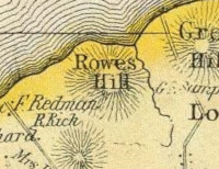
| Rowes Hill |
| • |
Google Maps | Google Earth - Google |
| • |
"...The shore line by Rose Hill is passed, and we come down into alovely little bay which has since been called Wessagusset Beach...", Joy, Vol. 1, pg. 114, 1923 - HathiTrust |
| • |
"...Names and Nicknames - Roes Hill, west of Great Hill...", Joy, Vol. 1, pg. 301, 1923 - HathiTrust |
| • |
"...Hugh Rowe (Roe) had land granted to him at Weymouth, west of John Burrell's, north of Richard Waling's, on King Oke Hill,
north of John Whitman's, south of Robert Lovell's...", Chamberlain, Vol. 4, pg. 606, 1923 - HathiTrust |
|
| Upper Neck |
|
| Watch House Hill |
| • |
Google Maps | Google Earth - Google |
| • |
"...The first Meeting House was built on Watch House Hill before 1645. The Meeting House was used for religious services and also town affairs were conducted there. Watch House Hill is part of the North Weymouth Cemetery, also known as "Old North" Cemetery...", Historic Sites, Weymouth, Massachusetts - Google Maps |
| • |
"...Old North Cemetery, once called 'Burying Hill,' east of the highway being the site of the First Church, is understood...", Weymouth 300th Anniversary Booklet (PDF), Weymouth Historic Preservation - Town of Weymouth |
| • |
"...Behind him when he turned, the land was spread out in its natural beauty, and in the distance could be seen the hill later called Watch House Hill and Church Hill, and beyond it, rising higher into the air, was what is now King Oak Hill...", Joy, Vol. 1, pg. 114, 1923 - HathiTrust |
|
| Weymouth Great Hill |
| • |
USGS location - Oliver MassGIS Online Mapping Tool |
| • |
Google Maps | Google Earth - Google |
| • |
"...To the left extended what we now call Bradley's Neck and the mouth of Back River, and in full view rose the great hill, later called Smith's Hill, and now Weymouth Great Hill...", Joy, Vol. 1, pg. 111, 1923 - HathiTrust |
| • |
Weymouth Great Hill - USGS Geographic Names Information System |
|
| Whites Neck |
| • |
USGS location - Oliver MassGIS Online Mapping Tool |
| • |
Google Maps | Google Earth - Google |
| • |
"...This neck is very important. It is now a little settlement called
Idlewell, but away back in 1630, somewhere near the neck, Capt.
Thomas White, one of the early settlers, lived...Old residents tell how people were in the habit of
standing on White's Neck watching the Indians in their canoes
coming up and down the river into Mill Cove and through the Mill
Creek...", Joy, Vol. 1, pg. 121, 1923 - HathiTrust |
| • |
Whites Neck (Cape) - USGS Geographic Names Information System |
|
|
|
 |
|
 |
|
 |
|
 |
|
| Great Esker |
 |
|
| Honey Hill |
 |
|
| House Rock |
 |
|
 |
|
| Rowes Hill |
 |
|
| Weymouth Great Hill |
 |
|
 |
|
 |
|
| |
|
|
| More about Weymouth's USGS-listed hills |
|
Weymouth was first settled in 1622 making it the second-oldest European settlement in Massachusetts after Plymouth, and the oldest in the Boston Basin Hills survey area. Unlike at Plymouth, there were fits and starts in the settlement of Weymouth. The first group that arrived, all men, was there not in search of religious freedom religious freedom but to make money trading with the Native Americans. Unfortunately, they were ill prepared for a harsh winter and by spring the trading post they had established was abandoned. That fall a new group, this time with families, arrived with a goal of starting a new colony. The plan had been to settle somewhere along the Charles river, but faced with bad weather and the need to find housing quickly before winter, the group moved into buildings abandoned by the earlier settlers. Unlike the separatists Pilgrims in Plymouth, and the yet to arrive Puritans, the second group of settlers at Wessagusset, the Native American name for the place, were Anglicans attempting to expand the influence of the Church of England in the new world. Again, unfortunately, support from England disappeared and the harsh winter took its toll. Many of settlers returned to England, some moved to more-Anglican friendly Maine and Virginia, a few moved to locations on the Charles river becoming the “old planters” John Winthrop encountered when he arrived in 1630, and a small group stayed starting a new village. |
| In 1635 the Massachusetts Bay Colony incorporated the village as a town giving it the name Weymouth. This coincided with the arrival of a Puritan group of 21 families lead by the minister Joseph Hull. Like many other towns in New England, Weymouth was named after a town or city in England. Often it was the home town of the minister, but not in the case of Weymouth. Hull was from Crewkerne in Somerset, England. There were families from Weymouth in the group, and there also are records of the name Weymouth being used for the area before 1635. |
| Unlike the story of the Pilgrims and their famous first step on Plymouth Rock, there are contradictory interpretations of where the first settlement was located.1 Some put the settlement in what is now called Kings Cove on banks of the outer Fore River and nearer Hingham Bay. Others say the settlement was in a more sheltered area further up the Fore River in what is now called Mill Cove. The area of the original village was called Old Spain. Why Old Spain? The common explanation, no one knows. There are some suggestions made, two seem almost seem humorous and the other makes perfect sense.2 One explanation, it was common at the time for people to say, “there is nothing between us and Spain” but ocean, even though Weymouth is located well into the harbor with no direct view of the Atlantic Ocean. The second possible explanation, the village is located where Native American trails met at the ocean. There could have been a yet undiscovered Spanish camp there where trade took place with the Native Americans, who then would have had to have told the later arriving English settlers about its existence. There has never been any proof that such a camp ever existed. The third possible origin for the name Old Spain makes the most sense but none will say it’s the most likely reason. The leader of the second settlement effort was Robert Gorges (1595-c.1628), the son of Ferdinando Gorges (c.1567-1647), a man who had a royal charter for that portion of New England. Even though the Gorges were English, the name sounded Spanish. |
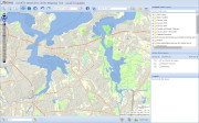
Necks, Points and Capes
| |
 |
|
 |
| |
|
|
|
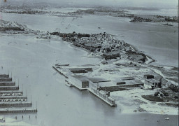
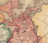
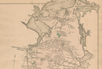
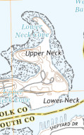
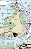
The Native American word Wessagusset is commonly translated to mean a small salt water cove. The USGS recognizes both Mill Cove and Kings Cove classifying them as Bays. The companion to a Bay for the USGS is a Cape, and USGS recognizes eight Capes in Weymouth. In any Boston Basin town not on the coast these wouldn’t even be considered hills. Several have elevations under 10 feet. Eastern Neck (7 ft., Cape) is the peninsula between the Weymouth Fore and Back Rivers. There is little or no mention of a complimentary Western Neck today, but records from the 1600s there are references to a “Wester” neck and land some of which was owned by John King (c.1600-c.1670).3 The King of Kings Cove. He was the servant of John Humphrey (c.1597-1661), a Deputy Governor of the Massachusetts Bay Colony. Humphrey settled in New England in 1631 so likely King did also. King had land granted to him in Saugus but was settled in Weymouth by 1639. At the end of Eastern Neck and two more Necks, Lower Neck (13 ft., Cape) and Upper Neck (33 ft., Cape). There is an interesting conflict between the latest USGS National Map and earlier topographic maps as well as NOAA chart in the location of Lower Neck. Except for the National Map, Lower Neck is further out the neck than Upper Neck. On the National Map Lower Neck is south of Upper Neck. Logically its lower on the map, but not if you are in a boat. Midway out Eastern Neck, on the Fore River side, is Fort Point (10 ft., Cape). There is reference to fort being located there during any of the settlement efforts in the 1600s. Howard Joy in the Names and Nicknames section of his 1923 History of Weymouth identifies ar alternative name for the location, Trufants Point.4 After the British left Boston during the Revolutionary War, independent military companies were stationed along the coast at Dorchester Height, Braintree (now Quincy), Weymouth and Hingham. Joseph Trufant (1701-1778) was in a command of the company stationed in Weymouth. Perhaps Fort Point is where they were located. |
|
Hunt Hill Point (0 ft., Cape) is one of the two locations suggested for the first settlement in Wessagusset, though there were no Hunt’s among the first three groups of settlers. Enoch Hunt (c.1595-c.1650) and his son Ephraim Hunt (c.1610-1687) were in Weymouth by 1640.5 Enoch went back to England. Ephraim stayed and married Anna Richards (1626-c.1654). It is not clear if they one of their many descendants possibly owned land on the cover that would carry their name. Their son, Ephraim Hunt, Jr. (1650-1713), was a shipbuilder with a yard further back of Fore River. Edward S. Hunt. Generations later, Edmund S.S. Hunt (1827-1909) developed a line throwing cannon to rescue distressed ships. He also operated a fireworks factory in Weymouth, was an author, and a manufacturer of ladies’ fans. But it couldn’t have been Edmund because a circa 1800 map labels the point as Hunts Hill. |
|
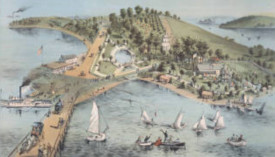
Looking at the area between Ferry Point (0 ft., Cape) and Pine Point (0 ft., Cape) today it’s difficult to imagine that the current flat, industrial site once featured “extensive groves, beneath whose arching bowers fully a thousand people can be sheltered from the sun’s rays.” It was Lovell’s Grove where “swings, flying horses, billiards, bowling, boating and bathing furnish an endless source of amusement.” In the middle-to-late 1800s Boston city dwellers could take a steamboat to the popular resort area and if they wanted, stay at the Pine Point Hotel located there. In the early 1900s interest in the resort waned when Paragon Park on Nantasket Beach opened with its larger variety of rides and amusements. Opposite the growing Fore River Shipyard, the Lovell’s Grove area was becoming more industrial, and in 1911 the land was bought by an electric company for a location to build a large power plant. Two family names are connected with the area. One is obviously Lovell. Robert Lovell (1595-1672)6 with his wife Elizabeth (Dunkley) Lovell (1601-1657) and their four children were one of the 21 families in the Joseph Hull group arriving in Weymouth of 1635. The other family name is Kingman.7 Steamboats going to Lovell’s Grove tied up at a place known as Ferry Point in Weymouth. That location was also the Weymouth end of bridge that had been constructed in 1812 across the Fore River to Quincy Point. Before 1812 if you wanted to get across the river you had to take a ferry. The first ferry was run by Henry Kingman (1595-1667). He and his wife Joanna (Drake) Kingman (c.1596-1659) with their five children were also in Hull’s first group of 21 families. |
|
|
The final USGS-listed hill-like feature on the Weymouth Neck is Rose Cliff (3 ft., Cliff). Discovering the origin of its name presents a challenge. There is a nearby non-USGS-listed hill that appears on maps called, alternately, Rowe, Rowes, and Roes Hill. That hill was likely named for Hugh Roe (c.1617-1689). He immigrated to Weymouth c.1642 and would leave in 1657 with his family for Suffield, Conn. on the Connecticut River. Rose Cliff is located further out on the Weymouth Eastern Neck, but exactly where varies by map. On some maps Rose Cliff is shown next to Fort Point, on others it’s near the end of the Upper Neck Cove, and on still others it’s right in the middle on or next to a low hill. There is no mention of Rose Cliff in the early histories written about Weymouth. The area is mentioned about an incident during the Revolutionary War known as the Battle of Grape Island. Now part of Hingham the island had been part of Weymouth. When British troops raided there to collect hay they were fired on by Colonialist assembled near Rose Cliff, though not identified by that name at the time. There were no casualties, and the British left before the colonialist could get to island by boat. Rose Cliff begins to be mentioned in the 1890s as a place for summer cottages and sailing. In the 1909 Atlas for Weymouth and Braintree Rose Cliff is a road well to the eastern end of the neck and very close to the Bradley Fertilizer Factory. In the 1870s William L. Bradley (1826-1894) had relocated his fertilizer manufacturing business from South Boston to the Weymouth. It would become the largest fertilizer factory in the world and Bradley would own much of the Eastern Neck. NOAA charts also locate Rose Cliff in this same area to the east. |
| Whites Neck (13 ft., Cape) forms one side of Mill Cove in the inner Weymouth Fore River harbor. Mill Cove thought by some the location of the first settlement at Wessagusset. Thomas White (c.1599-1679)8 immigrated to Weymouth in 1635, though his name does not appear as part Hull group. Numerous generations of Whites lived in the area. A White from a different family with a unique story lived in Weymouth for a time. Peregrine White, Jr. (1660-1727) was the of Peregrine White (1620-1704)9. He was the first baby boy born on the Mayflower in the harbor of Massachusetts, the second baby born on the Mayflower's historic voyage, and the first known English child born to the Pilgrims in America. His son lived in Weymouth for a time before moving to Middleborough and then Boston. |
| Weymouth, along with its capes, points, and necks, has two USGS-listed features that are categorized as Summits. |
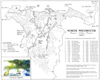
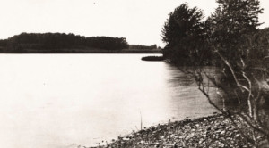
| Owing to what appears an omission in the USGS system, there is no elevation given in the GNIS record for Weymouth Great Hill (NA ft.). The hill is also not labelled on the National Map. Based on contour lines on the topographic map the elevation is between 140 and 150 feet. Great Hill is popular name for a hill. The nearby towns of Quincy, Hingham, and Hull all have hills that are, or were, named Great Hill. The explanation is that early settlers called whatever hill they thought was the tallest in their town, Great Hill. In the case Weymouth’s Great Hill, it was first known as Smiths Hill. There were multiple Smiths who were early immigrants in New England. Weymouth’s most famous Smith is Abigail Smith (1744-1818), the wife of the second president of the United States, John Adams (1735-1826). But it wasn’t one of her ancestors that gave their name to the hill. She is a descendant of Thomas Smith (1645-1690) who immigrated to Charlestown. James Smith (1610-1676)10 was in Weymouth as early as 1639. He is the Smith of Smith’s Hill. |
| King Oak Hill (151 ft.), Weymouth’s tallest, was likely named for John King (c.1600-1669).11 Histories written about the town identify him as the source of the name of King’s Cove and a forested area called King’s Grove. He also owned land on what has been called from the very earliest time, King Oak Hill. The histories do not identify him as the source of the name for the hill, but they don’t identify a different source. John King was a member of the very first 1622 settlement effort at Wessagusset. When that failed he first moved to Maine, then back to England. Jump to 1639, he’s married and back in now Weymouth the beneficiary of some of the first land grants. Its thought that he with his wife were back in New England as early as 1631 both as servants to Deputy Governor John Humphrey (1597-1661). |
|
|
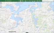
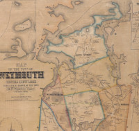
| Weymouth Maps |
| • |
Weymouth - Google Maps, Terrain |
| • |
Weymouth - OLIVER: MassGIS's Online Mapping Tool |
| • |
Weymouth - USGS - The National Map |
| • |
Hull Quadrangle - 2018 (60 MB PDF) - USGS Topo Download |
| • |
Weymouth Quadrangle: 2018 (60 MB PDF) - USGS Topo Download |
| • |
North Weymouth History Map, 1622 (PDF) - Town of Weymouth |
| • |
Manuscript Map of the Town of Weymouth, circa 1800 - Massachusetts Historical Society |
| • |
Map of the Town of Weymouth, Norfolk County, Mass, Henry F. Walling, 1853 Weymouth Public Libraries, Tufts Library, Digital Commonwealth |
| • |
Map of Norfolk County, Massachusetts, Henry F. Walling, 1853 - Library of Congress |
| • |
Weymouth, Atlas of Norfolk County, Massachusetts, Comstock & Cline, 1876 - Old Maps |
| • |
Map of Norfolk County, Massachusetts, Henry F. Walling, 1858 - David Ramsey Map Collection |
| • |
Map of Norfolk County, Massachusetts, Smith & Bumstead, 1858 - Library of Congress |
| • |
Atlas of Braintree and Weymouth, Massachusetts, Walker Lithograph Co., 1909 - State Library of Massachusetts |
| • |
Historic Sites, Weymouth, Massachusetts - Google Maps |
| • |
Atlas of the boundaries of the towns of Cohasset - Weymouth, Norfolk County Hingham - Hull, Plymouth County, 1901 - State Library of Massachusetts |
|
|
| Weymouth Sources |
| • |
Proceedings on the Two Hundred and Fiftieth Anniversary of the Permanent Settlement of Weymouth, Charles F. Adams, 1874 - HathiTrust, Internet Archive |
| • |
Weymouth in its First Twenty Years, with some Facts and Queries Concerning its First Church and Ministers, Gilbert Nash, 1883 - HathiTrust |
| • |
Historical Sketch of the Town of Weymouth, Massachusetts, from 1622-1884, Gilbert Nash, 1885 - Internet Archive |
| • |
History of Weymouth, Massachusetts, Vol. 1, Vol. 2, Howard H. Joy, 1923 - HathiTrust |
| • |
History of Weymouth, Massachusetts, Vol. 3, Vol. 4, George W, Chamberlain, 1923 - HathiTrust |
| • |
Weymouth, History of Norfolk County, Massachusetts, with Biographical Sketches of Many of its Pioneers and Prominent Men, Duane Hurd, 1884 - Internet Archive |
| • |
Weymouth Ways and Weymouth People: Reminiscences, Edmund S. Hunt, 1907 - HathiTrust |
| • |
Weymouth, History of Norfolk County, Massachusetts, 1622-1918, Louis A. Cook, Vol. 1, 1918 - Internet Archive |
| • |
Weymouth Massachusetts, A New Englad Town, Chester B. Kevitt, 1981 - Internet Archive |
| • |
Weymouth: Images of America, Debbie Sargent Sullivan, Joanne Palmieri Tighe, 2001 - Google ebook preview |
| • |
Weymouth: Postcard History Series, William J. and Elaine A. Pepe, 2004 - Google ebook preview |
| • |
Weymouth:Masschusetts, Legendary Locals, Debbis Sargent Sullivan, Erica Jill Dumont, 2013 - Google ebook preview |
| • |
Weymouth Historical Society Publications, 1810, 1885, 1905 - HathiTrust |
| • |
Weymouth Gazette, 1867-1921, Weymouth Public Libraries - Internet Archive |
| • |
History, A brief survey of Weymouth's past - Town of Weymouth |
| • |
Weymouth Historic and Digital Collections, Weymouth Public Libraries - Town of Weymouth |
| • |
Weymouth Historic Preservation - Town of Weymouth |
| • |
A Brief History of Weymouth, Building a Healthy Weymouth - Boston University |
| • |
Weymouth, MHC Reconnaissance Survey Town Report (PDF), 1979 - Massachusetts Historical Commission |
| • |
Weymouth Open Space and Recreation Plan, 2014 - Town of Weymouth |
| • |
Weymouth History (video) Mary Heinrichs - WETC |
| • |
Weymouth Historical Society |
| • |
Weymouth Historic Preservation - Town of Weymouth |
|
|
| Footnotes |
| 1 |
An Investigation into Weston's Colony at Wessagussett (PDF), Craig S. Chartier , 2011 - Plymouth Archaeological Rediscovery Project (PARP), SCRIB |
|
The Wessagussett Plantation - Plymouth Archaeological Rediscovery Project (PARP) |
|
The Hull Company, 2011 - Miner Descent |
| |
Site of Weston's plantation of 1622 at Wessaguscus, Charles F. Adams, Proceedings of the Massachusetts Historical Society, pg. 23, 1891 - Google ebook |
| 2 |
Trees, Animals and Fish, Joy, Vol. 1, pg. 128, 1923 - HathiTrust |
| 3 |
John King, Chamberlain, Vol. 3, pg. 349, 1923 - HathiTrust |
| |
The Passengers on Weston's Ships, William Hyde, Weymouth Gazette and Transcript, Nov. 4, 1921, Weymouth Public Libraries - Internet Archive |
| 4 |
Names and Nicknames, Joy, Vol. 1, pg. 301, 1923 - HathiTrust |
|
Joseph Trufant, Massachusetts Soldiers and Sailors of the Revolutionary War, pg. 82, 1896 - Internet Archive |
|
The Revolutionary War, Military History of Weymouth, (doc) - Genealogy Trivia of Karolyn Roberts |
| 5 |
Enoch Hunt, Chamberlain, Vol. 3, pg. 312, 1923 - HathiTrust |
| |
Weymouth Ways and Weymouth People: Reminiscence, Edward S. Hunt, 1907 - Google ebook |
| |
Life-saving Guns and Rockets, New International Encyclopedia, Volume 14, pg. 105, 1905 - Google ebook |
| |
Manufacturers, Fire-Works, Nash, pg. 312, 1885 - HathiTrust |
| |
Edmund S. Hunt Fireworks Company Building - Massachusetts Historical Commission Information System (MACRIS) |
| 6 |
Robert Lovell, Chamberlain, Vol. 3, pg. 392, 1923 - HathiTrust |
| |
A Biographical Genealogy of the Lovell family in England and America, Mary L. Rhodes, T.D. Toberts, 1924 - HathiTrust |
| 7 |
Henry Kingman, Chamberlain, Vol. 3, pg. 354, 1923 - HathiTrust |
| 8 |
Thomas White, Chamberlain, Vol. 4, pg. 731, 1923 - HathiTrust |
| 9 |
Peregrine White, Joy, Vol. 2, pg. 341, 1923 - HathiTrust |
| |
The story of one immigrant family, Andrew A. White, 2006 - The 10,000 Things |
| 10 |
James Smith, Chamberlain, Vol. 4, pg. 632, 1923 - HathiTrust |
| |
Smiths in Massachusetts Bay Colony, New England, Jane Smith Harrell, 2015 - Kinfolk Stories |
| |
James Smith of Weymouth, Jane Smith Harrell, 2015 - The Peter and Sally Family |
| 11 |
John King, Chamberlain, Vol. 3, pg. 349, 1923 - HathiTrust |
|
|