| The Town of Hyde Park was incorporated in 1868 in Norfolk County from settled land in Dorchester (Grew's Woods and the Hyde Park Land Company development), Milton (Fairmount) and Dedham (Readville). It remained a part of Norfolk County until 1912, when the town voted in favor of annexation to the City of Boston in Suffolk County. |
|
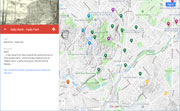
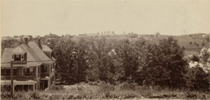
| Hills of Hyde Park - Boston, Mass. |
| Bald Knob |
|
| Bearberry Hill |
|
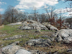
| Clarendon Hills |
| • |
Google Maps | Google Earth - Google |
| • |
"...Clarendon Hills, Fairmount and Mount Neponset, as well as the higher portions of Sunnyside, are composed of drift material brought here during the Glacial Age. Fairmount and Clarendon Hills are typical drumlins...", Hyde Park Historical Record, Vol. 2, pg. 9 , 1892, Ella F. Boyd - Internet Archive |
|
| Dell Avenue Rock |
| • |
Google Maps | Google Earth - Google |
| • |
Dell Avenue Rock, "...Dell Avenue Rock is a steep, rocky bluff of Mattapan volcanic rock that juts up nearly 40 feet from the street where three residential streets converge on Hyde Park Avenue...", Boston Urban Wilds Report, pg. 87, Boston Natural Areas Fund, 1990 - Internet Archive |
| • |
Dell Avenue Rock, "...Dell Avenue Rock consists primarily of a puddingstone ledge arising approximately 40 feet above Hyde Park Avenue...", Boston Urban Wilds - City of Boston |
|
| Fairmount Hill |
| • |
Google Maps | Google Earth - Google |
| • |
"...East of the Neponset River the land rise somewhat abruptly forming Fairmout Heights, the place where the pioneers of this new town first founded their homes...", Memorial Sketch of Hyde Park, Mass., pg. 10, Joseph K. Knight, 1888 - Google ebook |
| • |
"...They begin the first speculative housing development in the United States on Fairmount Hill. Their leader is 23 year old Alpheus Perley Blake (b. 1832), Hyde Park's founder ...", Hyde Park, Boston Family History - Boston History & Innovation Collaborative |
| • |
"...Clarendon Hills, Fairmount and Mount Neponset, as well as the higher portions of Sunnyside, are composed of drift material brought here during the Glacial Age. Fairmount and Clarendon Hills are typical drumlins...", Hyde Park Historical Record, Vol. 2, pg. 9 , 1892, Ella F. Boyd - Internet Archive |
|
| Greenwood Hill |
| • |
Google Maps | Google Earth - Google |
| • |
"...the biggest Sunday-school in town was on the Greenwood hill...", Hyde Park Historical Record, Vol. 5, pg. 42, 1905, William A. Mowry - Internet Archive |
| • |
"...Elihu Greenwood...The Greenwood School, Greenwood Avenue, and Greenwood Square, were all named in honor of him...", Hyde Park Historical Record, Vol. 6, pg. 54, 1908, William A. Mowry - Internet Archive |
|
| Monterey Hill |
|
| Mount Neponset |
| • |
Google Maps | Google Earth - Google |
| • |
"...The Unitarian Church Building...occupies a slightly and pleasant position at the junction of Oak and Pine Streets on Mount Neponset...", Memorial Sketch of Hyde Park, Mass., pg. 41, Joseph K. Knight, 1888 - Google ebook |
| • |
"...Clarendon Hills, Fairmount and Mount Neponset, as well as the higher portions of Sunnyside, are composed of drift material brought here during the Glacial Age. Fairmount and Clarendon Hills are typical drumlins...", Hyde Park Historical Record, Vol. 2, pg. 9 , 1892, Ella F. Boyd - Internet Archive |
|
| Pine Rock |
|
| Rooney Rock |
|
| Sally Rock |
| • |
MassGIS identified - MassMapper MassGIS |
| • |
Google Maps | Google Earth - Google |
| • |
"...Aunt Sally Sumner was the daughter of William Sumner of Hyde Park, and grew up and went to school from the old homestead on River St. Just south of the Tileston & Hollingsworth paper mill. She was of the family of the famous Senator Charles Sumner of Massachusetts and was noted for her interest in public affairs, especially in the antislavery agitation....", "Aunt Sally Sumner's Rock," Hyde Park, to be blown up, Boston Globe, Jul. 26, 1924 - Boston Globe (Subscription) |
| • |
"...1874: John Gately arrives from England and becomes a squatter on Henry S. Grew's property. Known as the "Hermit of Sally's Rock," Gately is eventually given an old shed from Grew which was listed as "The Hermitage" on many of the old maps of Grew's land ...", Hyde Park, Boston Family History - Boston History & Innovation Collaborative |
| • |
"...A few steps from here towards the west is the top of "Pine Garden Rock," which is today widely known as "Sallie's Rock," a spite name given it by the Hermit Gateley, and taken up by the people in ignorance of any other...", Hyde Park Historical Record, Vol. 8, pg. 26, 1912, Horace Sumner - Internet Archive |
| • |
"...On Feb. 2, 1875, James Gatley quietly died in Grew's Woods, a vast expanse of woods and hills on what was then the Hyde Park/West Roxbury town line, where he'd lived in a 10x12 hut for nearly three decades, studying and stuffing the local birds and reptiles....", The anniversary of the death of the Hermit of Grew's Woods will probably pass quietly today, Feb. 2, 2107 - Universal Hub |
| • |
Sally Rock - USGS Geographic Names Information System |
| • |
"...Eight parcels for play space, small park, urban wild, bike and pedestrian paths, and vista adjacent to the Roslindale Stop and Shop on American Legion Parkway in Hyde Park – Crane Ledge 23 acres.....", Vision for American Legion Parkway: Protect, Reclaim, Enhance, 2015 - WalkUP Roslindale |
| • |
"...On a sunny, but cool Saturday in March, a group of us from Hyde Park and Jamaica Plain explored Hyde Park's Crane Ledge and the surrounding neighborhood...", Stony Brook Valley from Crane Ledge Saturday, March 7, 2020 - MassPaths |
| • |
Possibly, “Lemuel Crane, eldest son of Elijah and Sarah (Houghton) Crane, was born in Milton, March 18th, 1757….was a soldier in a company of militia which was detailed to guard the troops of Burgoyne, when they were prisoners at Cambridge, and was called out on various alarms at other times…. In the year 1782 he bought a tract of land in the westerly part of the town, being a portion of the " Dorchester common land," sold by the town about that time. He subdued and cultivated a large farm, and attended the Boston market, occupying a stall in the westerly corner of Faneuil Hall building for many years. Mr. Crane was very fond of pomological pursuits, and a large number of apple trees, now in a thrifty and bearing state, remain as monuments of his industry and perseverance…. Mr. C. taught the first school established in. his neighborhood, in winter, from 1790 to 1797, and occasionally evening schools for apprentices in the paper mill, and other boys, and also a singing school, for which he was well qualified. He was a collector of town taxes for the years 1790 and 1792 — selectman and assessor in 1793, 1803, '4 and '5; assessor, 1807-12; representative to the General Court in 1811 — was usually one of the surveyors of the highways, and a member of the school committee of the district…”, History of the Town of Dorchester, Massachusetts, pg. 539, Ebenezer Clapp, 1859 - Internet Archive |
|
| The Perch |
|
|
|
 |
|
 |
|
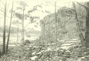
| Clarendon Hill |
 |
|
| Dell Avenue Rock |
 |
|
| Sally Rock |
 |
|
|
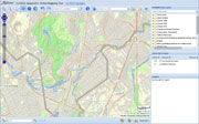
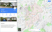
| Hyde Park Maps |
| • |
Hyde Park - Google Maps, Terrain |
| • |
Hyde Park - MassMapper MassGIS |
| • |
Hyde Park - USGS - The National Map |
| • |
Boston South Quadrangle - 2018 (60 MB PDF) - USGS Topo Download |
| • |
Newton Quadrangle - 2018 (60 MB PDF) - USGS Topo Download |
| • |
Norwood Quadrangle - 2018 (60 MB PDF) - USGS Topo Download |
| • |
USGS Historical Topographic Map Explorer |
| • |
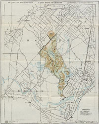
Atlas of Hyde Park, Norfolk County, Mass., Geo. W. Stadley & Co., 1899 - State Library of Massachusetts |
| • |
Atlas of Hyde Park, City of Boston, G.W. Bromley & Co., 1912 - State Library of Massachusetts |
| • |
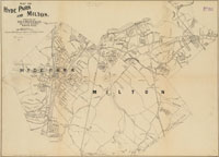
Map of Hyde Park and Milton, Edward A. Jones, 1904 - Norman B. Leventhal Map Center, Boston Public Library |
| • |
City of Roxbury, Massachusetts, Charles Whitney, 1849 - Norman B. Leventhal Map Center, Boston Public Library |
| • |
Flora of the Stony Brook Reservation, Metropolitan Park Commission, 1896 - WikiMedia Commons |
| • |
Plan of Boston and its Vicinity, Showing the Drainage Area of Stony Brook, H.M. Wightman, 1863 - Norman B. Leventhal Map Center, Boston Public Library |
| • |
Atlas of Dorchester, West Roxbury, and Brighton, West Roxbury, L.J. Richards, 1899 - State Library of Massachusetts |
|
|
| Hyde Park Sources |
| • |
Hyde Park Historical Record, Vol. 1, No. 1-4, 1891-1893, William A. Mowry - Internet Archive |
| • |
Hyde Park Historical Record, Vol. 5, 1905, William A. Mowry - Internet Archive |
| • |
Hyde Park Historical Record, Vol. 6, 1908, William A. Mowry - Internet Archive |
| • |
Hyde Park Historical Record, Vol. 8, 1912, William A. Mowry - Internet Archive |
| • |
Memorial Sketch of Hyde Park, Mass. Joseph K. Knight, 1888 - Google ebook |
| • |
Hyde Park, Boston 200 Neighborhood History Series, 1976 - Internet Archive |
| • |
Hyde Park: Images of America, Anthony M. Sammarco, 1996 - Internet Archive |
| • |
Hyde Park: Then & Now, Anthony M. Sammarco, 2011 - Google ebook preview |
| • |
Hyde Park, Boston Family History - Boston History & Innovation Collaborative |
| • |
Stony Brook Reservation Trail Map (PDF), Stony Brook Reservation - DCR, Commonwealth of Massachusetts |
| • |
1990 Boston Urban Wilds Report, Boston Natural Areas Fund, 1990 - Internet Archive |
|
|
|