| Hills of Woburn, Mass. |
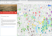
| | Hills | More about Woburn's USGS-listed hills | Maps | Sources | |
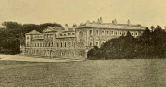
| Academy Hill |
| • |
Google Maps | Google Earth - Google |
| • |
"...Academy Hill, so named from the old Warren Academy, a famous institution in its day, is a short by-walk from Pleasant Street. The academy building is now used for a Free Industrial School, which is supported from the interest of Warren Academy funds in the hands of trustees....", Bacon, pg. 142, 1897 - Internet Archive |
|
| Blueberry Mountain |
| • |
USGS identified - MassMapper MassGIS |
| • |
Google Maps | Google Earth - Google |
| • |
"...To son John Brooks he gives that piece of land called by the name of English Hills...", William R. Cutter, Arthur G. Loring, The Brooks Family of Woburn, Mass., pg. 5, 1904 - Google ebook |
| • |
"...The earlier name of the English Hills applied to the present Mt. Pleasant, Judge Johnson found, first appears of record in the will of John Brooks, Sr., dated July, 1690. In a deed of date December, 1698, from Nathaniel Richardson to his son James, mention is made of " The Great Hill," by which was meant the highest of the Mt. Pleasant elevations, more commonly referred to in deeds of that period as "The Mountain." After the Revolution, when the name "English" fell into disfavor, the height was called "Brooks Mountain," because, as Judge Johnson shows, the whole or the greater part of it was owned by members of the Brooks family, who held it for about two hundred years. This name was retained until the middle of the present century. After that it came to be called indifferently Frog Hole Mountain, Blueberry Mountain, and Mt. Pleasant....", Bacon, pg. 134, 1897 - Internet Archive |
| • |
"...Further south-eastward, the prospect is bounded by Mt. Pleasant (270 feet), -- the series of tree-clad elevations which until the Revolution went by the name of the English Hills...", Bacon, pg. 134, 1897 - Internet Archive |
| • |
Blueberry Mountain Quarry (Blueberry Hill): "...Former stone quarries located in southeastern Woburn, on the Woburn-Winchester line. Some sources call the locality 'Winchester Highlands.'....." - Mindat.org |
| • |
Blueberry Mountain - USGS Geographic Names Information System
Variant names: Blueberry Hill, Mount Pleasant |
|
| Horn Pond Mountain |
| • |
USGS identified - MassMapper MassGIS |
| • |
Google Maps | Google Earth - Google |
| • |
"...The name of Horn Pond is more ancient than the town itself, being named in connection with the above lands in 1638, and also in Wood's Map of Massachusetts in 1633...", William R. Cutter, Winchester Record, Vol. 2, pg. 266, 1886 - HathiTrust |
| • |
"...They are crude drawings. Spot Pond, Mistick Pond and Horn Pond are named on both maps. Horn Pond is the name given to a pond which is plainly Spy Pond, in Arlington, and the true Horn Pond is not represented. The use of its name, however, shows that the cognomen is of greater antiquity than the town itself and older
even than the year 1638, when it was used in the description of the Waterfield lots. The map-makers of 1633 evidently did not have an intimate acquaintance
with the actual pond, or they would not have left it out of their maps. It is presumed that the whites had by that time penetrated to it and named it. Horn
Pond Mountain, though unnamed, is shown as a hill in Winthrbp's map, and three small ponds are represented near, intended to be the ponds in Winchester,
known as Wedge and Winter Ponds....", Hurd, Vol. 1, pg. 340, 1890 - Internet Archive |
| • |
"...The [Wakima] legend...'Occasionally at night strange sounds were heard from the top of Mianomo (Rag Rock), while ever and anon flashes of light appeared on the crest of Towanda (Horn Pond Mountain)'...", Converse, Vol 2, pg. 65, 1896 - Internet Archive |
| • |
"...It was at Lake Innitou or Horn Pond, that the long sharp descent presented the greatest engineering difficulties on the route....", Converse, Vol 2, pg. 89 , 1896 - Internet Archive |
| • |
The Swan of Light, "...There was no island on Horn Pond, Massachusetts, in the long ago. When it was
Lake Initou the red men worshipped so many lesser gods that they had no time to praise the one Master of Life...", American Myths & Legends, Vol.1, pg. 83, Charles M. Skinner, 1903 - HathiTrust |
| • |
Horn Pond Mountain: "...in the late 40's and early 50's they had a tow rope and an annual 'winter fest' ski contest on "Mount Towanda'.....", New England Lost Ski Areas Project |
| • |
Horn Pound Mountain - USGS Geographic Names Information System |
|
| Listening Hill |
| • |
Google Maps | Google Earth - Google |
| • |
"...There are in the present limits of Woburn several elevations over 200 feet in height above mean sea level, according to the results obtained by the United
States Coast and Geoditic survey. Listening: Hill, the highest point, attains a height of 300 feet above sea level. The earliest mention we have found of the name "Listening Hill," is 1720, in an unrecorded deed, in which the "old Sawmill dam" and "upper millpond" are mentioned (Never's Pepers, Woburn Public Library), the dam and pond being located in the present Shaker Glen, where their remains may be seen today. Whispering Hill is sometimes confounded with Listening Hill being a part or extension of the same elevation. This is undoubtedly an old name...", Cutter, pg. 9, 1892 - Internet Archive |
| • |
"...to a slightly more elevated point, the eye sweeps over Cummingsville to the lovely country beyond, with Whispering and Listening Hills toward the southwest...
...The hill, rising 260 feet, is slightly higher than Rag Rock, but the view from it is more contracted because of higher hills in the neighborhood...
...Occasionally we can discern farms and pastures in opens on the slopes and in the grand sweep of trees below, and we may hear the tinkling of cow-bells, as the early settlers heard them when they came up here to listen for their strayed cattle, and so gave
the hill its poetic name two and a half centuries ago...", Bacon, pg. 134, 1897 - Internet Archive |
| • |
"...The first one took place on June 17, 1876, in the glen near Listening Hill in Woburn, known as Shaker Glen, with about fifty people participating...", Charles Hudson, History of the Town of Lexington, pg. 484, 1913 - Internet Archive |
| • |
"...The name "Listening Hill" is as ancient as the town itself. It is said that it derives from early farmers who would climb to the 300-foot summit to "listen" for the cowbells of stray livestock in the meadows and pastures below...", The Quail Runner, Sep. 2010 (PDF), (from, Woburn: Forgotten Tales & Untold Stories, Tom Smith) - The Quail Runner |
|
| Meeting-House Hill |
|
| Mount Gilboa |
| • |
Google Maps | Google Earth - Google |
| • |
"...Before reaching the Centre we turn at the left into Charles Street, our route being to the eastward section and the picturesque height known as Mt. Gilboa (220 feet)...The path up Gilboa starts in the field just beyond the first house on the rise (that of Mr. Elmore A. Pierce, of the park commission). It is an easy ascent to the summit with an expanding-view to the north and northwest, as it is approached... Mt. Gilboa is commonly known in the neighborhood as Converse Hill, from its long ownership, in large part, by the Converse family. Joshua Converse, the first to acquire the hill, lived to the remarkable age of one hundred and one years and sixteen days...", Bacon, pg. 140, 1897 - Internet Archive |
| • |
Likely reference to Biblical Mount Gilboa - Wikipedia |
|
| Powder-House Hill |
| • |
Google Maps | Google Earth - Google |
| • |
"...The hill, upon the side of which this burying-ground lies, was anciently called Mt. Seir, but for many years it went by the name of Powder-House Hill; and on its very apex, a little outside of the limits of the burying-ground, still stands one of the old brick powder-houses, so many of which were erected in assachusetts
towns during the War of 1812...", Bacon, pg. 142, 1897 - Internet Archive |
| • |
"...Bell Hill, 1678; otherwise known in the seventeenth century as the "Rock" and "Mount Seir." In 1812 the town powder-house was built upon it, and hence it acquired its present name of Powder House Hill. It adjoins the Central House estate on the north. The bell for the church-going public of the early time was placed on the hill, so that it could be better heard: hence the name Bell Hill… ", Cutter, pg. 8, 1892 - Internet Archive |
| • |
"...The people were called to worship by a bell which was erected on Bell Hill, later Powder House Hill, and now being the height of land to the top of Mann's Court....", Patricia Ann Deehan, pg. 25 (PDF), 1950 - Boston University |
| • |
"...they were notified of the hour by a bell hung on a hill in the neighborhood, (probably that back of the old Fowle tavern stand,) which was called from this circumstance many years after, Bell Hill...", Sewall, pg. 79, 1860 - Internet Archive |
| • |
"...Powder House, 1812, Hill Called Mount Seir, 1675 and Site of First Bell Tower in Rear of this spot ...", On Independent Baptist Church, 446 Main Street - Woburn 250th Anniversary, pg. 201, 1893 - Internet Archive |
|
| Rag Rock Hill |
| • |
USGS identified - MassMapper MassGIS |
| • |
Google Maps | Google Earth - Google |
| • |
"..."Rag" (Old English) seems to mean "rugged, or rocky." Example: Rag-dale, Leicester. It indicates the character of Woburn's rocky height —"RagRock." This name appears in our Woburn Records as early as the year 1648...", William R. Cutter, Winchester Record, Vol. 2, pg. 266, 1886 - HathiTrust |
| • |
"...The underlying rock is sienite, a huge mass of which called "Rag Rock" lifts its head near the central village...", Elias Nason, A Gazetteer of the State of Massachusetts, pg. 563, 1874 - Google ebook |
| • |
Wabanowi, The Seer. A Legend of Mt. Mianomo (Rag Rock), "...over whose flashing waters glided several canoes filled with Aberginian Indians, returning to their village in the shadow of Mianomo (Rag Rock)...", Converse, Vol. 1, pg. 1, 1892 - HathiTrust |
| • |
Rag Rock,"...Rag Rock, once known as Mount Mianomo by the Pawtucket Indians, was a vast area that included wooded hills and rocky slopes that spread over much of West Woburn...", Woburn Residents' Environmental Network (WREN) |
| • |
"...Perhaps a favorite hike of every youngster is the trip to the top of Rag Rock in the West Side. From the top of this rock on a clear day can be seen the dome of the State House and also in the distance, Mount Wachusett. This rock was kriown to the Aberjinians as Mount Mianomo....", Patricia Ann Deehan, pg. 11, 1950 (PDF) - Boston University |
| • |
The Long Sleep, "...Mount Mianomo, or Rag Rock, in eastern Massachusetts, was one of the dead monsters that had crawled down from the north with ice and stones on its back to desolate the sun god's land...", American Myths & Legends, Vol.1, pg. 63, Charles M. Skinner, 1903 - HathiTrust |
| • |
Rag Rock Hill - USGS Geographic Names Information System |
|
| Snow Hill |
|
| The Island |
| • |
"...The Island, 1657; adjoining New Bridge Field. It was also near the swamp in Boggy Meadow Field, between that and Step Rock. Gershom Flagg was granted an “island” at Step Rock in 1684, evidently referring to the same. The recent State map … shows an elevation of 100 feet… known as the “Island,” but not as an island surrounded by water, but as an island surrounded by swamp or level land… ", Cutter, pg. 6, 1892 - Internet Archive |
|
| Turkey Hill |
| • |
"...Turkey Hill, 1650. The location of William Johnson's old Sawmill (1680) in present Shaker Glen, in the westerly part of present Woburn...", Cutter, pg. 7 , 1892 - Internet Archive |
| • |
"...At length we reach an open where our brook — Turkey Hill Saw-Mill Brook, by name, given it by the early settlers — meets the John Johnson Saw-Mill Brook, coming over from the old Kendall Mill region...", Bacon, pg. 137, 1897 - Internet Archive |
|
| Walnut Hill |
| • |
Google Maps | Google Earth - Google |
| • |
"...To the south of us lies the Walnut Hill shooting-range, of the Massachusetts Rifle Association, occupying a large tract of land in the quarter anciently known as " Button End," with its targets in the neighborhood of " Buck Meadow " in the Aberjona
valley not far from the John Harvard lands...", Bacon, pg. 139, 1897 - Internet Archive |
| • |
Massachusetts Rifle Association History, "...The Massachusetts Rifle Association, "America's Oldest Active Gun Club", has undergone many changes but still remains to this day on "Walnut Hill" in Woburn, Massachusetts just north of Boston near the intersection of routes 128 and 93..." - Massachusetts Rifle Association |
|
| Whispering Hill |
| • |
USGS identified - MassMapper MassGIS |
| • |
Google Maps | Google Earth - Google |
| • |
"...Adjacent to Mary Cummings Park itself is another 100 acres of protected conservation and recreation land, including a 75-acre parcel known as Whispering Hill.....", About the Park - Friends of Mary Cummings Park |
| • |
John Cummings, Treasurer of the Institute 1872-1889, The Technology Review Vol. 1, pg.184, Massachusetts Instute of Technology,1899 - HathiTrust |
| • |
John Cummings, Samuel A. Eliot, Biographical history of Massachusetts, 1914 - Google ebook |
| • |
The Portrait of John Cummings, The Technology Review, Vol. 42, pg. 291, Massachusetts Instute of Technology,1920 - Internet Archive |
| • |
The Cummings Memorial, a Genealogical History of the Descendants of Isaac Cummings, George Mooar, 1903 - Internet Archive |
| • |
Cummings Genealogy: Isaac Cummings, 1601-1677 of Ipswich in 1638 and some of his Descendants, 1893 - Internet Archive |
| • |
John Cummings, "...The western part of Woburn was known as Cummingsville due to the influence of the Cummings family. David Cummings established the tanning business in the area shortly before the War for Independence..." - Massachusetts Historical Commission Information System (MACRIS) |
| • |
Whispering Hill - USGS Geographic Names Information System |
|
| Woods Hill |
| • |
Google Maps | Google Earth - Google |
| • |
"...From this report as recorded, it appears that they had laid out about 141 acres,lying in Wilmington "great lot," Wood Hill, on the west side of Clear Meadow brook, and on the east and west sides of Map!e Meadow River...", Sewall, pg. 41, 1860 - Internet Archive |
| • |
"...Wood Hill, 1668. Another name of the present time. Lcoation, Burlington, on line of Wilmington and Woburn… ", Cutter, pg. 8, 1892 - Internet Archive |
| • |
Wood Street: "...William Wood who lived at the foot of Wood's Hill and from whom the hill gets its name...", List of Accepted Streets in Woburn, Mass. 1898 (PDF) - City of Woburn |
|
| Zion Hill |
| • |
USGS identified - MassMapper MassGIS |
| • |
Google Maps | Google Earth - Google |
| • |
"...Zion’s Hill, Like Mt. Pisgah, a biblical name for one of the western cluster of hills...", Names of Places in Winchester - Town of Winchester, Massachusetts |
| • |
"......to a narrow path between the trees on the left of the road, where we enter the woods of the Zion's
Hill (325 feet) region. From this entrance-path we make a sharp turn to the right and, going northward, ascend the hill gradually, at length reaching the summit at a point from which we get the fairest outlook...", Bacon, pg. 144, 1897 - Internet Archive |
| • |
Laurence G Hanscom Field (BED) Navaids Info: Shaker Hill NDB - AirportDatabase.net |
| • |
Zion Hill - USGS Geographic Names Information System |
|
|
|
 |
|
 |
|
 |
|
 |
|
 |
|
 |
|
 |
|
 |
|
| Academy Hill |
 |
|
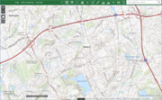
| Horn Pond Mountain |
 |
|
 |
|
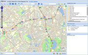
| Blueberry Mountain |
 |
|
| Powder-House Hill |
 |
|
| Rag Rock Hill |
 |
|
 |
|
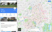
| Walnut Hill |
 |
|
| Whispering Hill |
 |
|
| Zion Hill |
 |
|
|
|
| More about Woburn's USGS-listed hills |
|
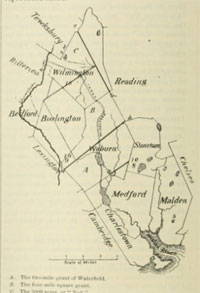
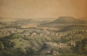
Officially settled in 1640, then incorporated in 1642, Woburn was the first of the expansion towns created from the original Charlestown land grant, and one of the earliest towns incorporated overall in the Boston Basin Hills survey area. From the original Woburn would split off Winchester, Burlington, and parts of Stoneham and Wilmington. By the mid-1630s, only five short years after John Winthrop first set foot in the Charlestown, there was no land on the peninsula available for newly arriving Puritans. The land in what would become Somerville was quickly being allocated, Medford was already a town, and the Cradock Plantation (today’s Medford) was already spoken for. Land further north into the rim of the Boston Basin was available, but barely explored. For settlers anxious to claim land, to the east was the Lynn land grant (today’s Reading and Wakefield), and to the west the Cambridge land grant (today’s Lexington). In 1635 a first group from Charlestown got approval from officials to explore the area, then in 1638 permission to survey for a road and layout lots for citizens of Charlestown. Approval to settle the area was delayed when the availability of a land just for the asking lead to concerns among Charlestown officials that too many people would leave their town. And there were other delays including, a disagreement on where the center of the new town should be located, needed negotiations with Lynn and Cambridge officials on the new town's borders, and then problems finding a minister that was required before a town could be officially incorporated. By 1642 everything was in place and the town of “Wooburne” was created. |
|
It is not recorded why the name Woburn, as it is now spelled, was chosen. The area along the Aberjona River had been called Waterfield, and just to the east was Rockfield, today’s Middlesex Fells. Then, for a short time, the area was called Charlestown Village. Typically, colonial towns in New England were named for the town in England where either the first settlers came from, or the minister who lead them. But that’s not the case for Woburn. There is a village in England named Woburn, but neither the first settler, Edward Converse (1588-1663), nor the first minister, Thomas Carter (1608-1684), was from there. Lacking a definitive explanation for the naming, several theories have been proposed, some very unique. The most widely accepted explanation is that Woburn was named for the hometown of Robert Sedgwick (1613-1656). A prominent citizen of Charlestown, he was a military man, captain of the Charlestown “train band”, active in the construction of the early defenses of Boston, and one of the founders of the Ancient and Honorable Artillery Company of Massachusetts. He never lived in Woburn, Mass., but played an important role in its founding. It is possible that Woburn named in honor of another prominent citizen from Charlestown, Richard Russell (1611-1676). He was elected representative to the Massachusetts General Court, a speaker of the House of Deputies, and served as the Colony’s treasurer. His relatives in England were a noble family and proprietors of the Woburn Abbey, a substantial estate still in the Russell family today. Richard Frothingham in his 1845 History of Charlestown put a political spin on the selection noting that Woburn in England was the home of John Goodwin (1564-1634), a politician at the center of a constitutional crisis. His case established the doctrine that the English House of Commons, not the King, had the sole right to validate elections. The Puritans would have appreciated the dissent. William R. Cutter, writing in the 1885 Winchester Record, proposed that the name Woburn corresponded to the physical location of the first settlement in the town at a bend in the Aberjona River. In his reasoning it matched the Old English “wo” meaning turning, and “bourne” for brook, matching the location along the Aberjona River where Edward Converse built the first house in Woburn. |
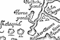
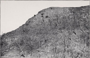
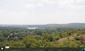
| One of earliest maps that showed features of the interior of New England appeared in William Wood’s book, New England’s Prospect, published in 1634. On the map a body of the water in the interior is labeled, “Horne ponds.” It is not known why Wood’s gave the pond that name, but it is how the nearby USGS-listed Horn Pond Mountain (279 ft.) received its name. Another hill in Woburn that received a name very early, and has never changed, is USGS-listed Rag Rock Hill (239 ft.). According again to Cutter in the Winchester Record, the hill appears by that name in town records as early as 1648. Both of these hills share another distinction, they were given different names by Parker L. Converse (1822-1899) in his 1892 book, Legends of Woburn. According to him, Native Americans called Horn Pond Hill, Mount Towanda, Rag Rock Hill was Mount Mianomo, and Horn Pond, Lake Innitou. The fantastical stories he wrote dealt with, “children of the forest”, “works of the Great Spirit”, brilliant lights from “deep beneath the water”, and an “enormous bird” slowly expanding its “gorgeous wings of light.” Other than for identifying actual Native American tribes, there is no evidence that any of the people he mentions ever existed, or the events ever occurred. In the preface of the book he explains that the stories “were mostly handed down in times, when the telling of them constituted part of the evening amusements of the winter fireside, and the delight of boys and girls of a summer night.” Converse was a prominent citizen of Woburn and had been a respected District Court Judge. Also, an excellent story teller. It would be interesting to know if there was any historical accuracy to his tales of Native Americans. |
|
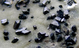
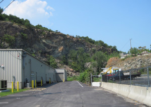
A trivia question that likely most people would not be able to answer is, what is the Massachusetts state mineral? It’s Babingtonite, and the small black crystals could be found among the crushed rock that was the primary product of the quarry at USGS-listed Blueberry Mountain (272 ft.) in Woburn. In operation from 1913 until the mid-1960s, the quarry was not a good neighbor because of blasting involved. Efforts were made to close it in the late 1920s and then again in March of 1950 when the company quarrying there made the front page of the Boston Globe when they set of seven tons of dynamite. The blast shook houses and buildings up to three miles away. In an official statement made the next day, the president of the company said the stone was needed for construction of Route 128, was done in accordance of state rules and regulations, and was supervised by a professor in charge of a seismological station at Harvard University. The hill has gone through a number of name changes, though none related to Native Americans. It was labeled Blueberry Mountain on the 1903 USGS topographic map, but Mount Pleasant on an 1893 map. An earlier name was Brooks Mountain in honor of John Brooks (c.1623-1691). He was the son of the immigrant Henry Brooks (1591-1683), who called the area English Hills in his will. It was thought the name was changed when it became unpopular during the Revolutionary War. |
| USGS-listed Whispering Hill (269 ft.) is in the western part of Woburn called “World’s End” by William R. Cutter (1847-1918), the Woburn town librarian from 1882-1909, in his 1892 book, Woburn Historic Sites and Old Houses. The area was primarily farms and woodlands up until almost the 1950s. Whispering Hill today is in a park owned by the City of Woburn, and it, combined with the land of the adjacent Mary Cummings Park in Woburn and Burlington, make it the 10th largest open space in the Boston Basin area, just behind the Stony Brook Reservation in West Roxbury and Hyde Park. Keeping it open space hasn’t been easy. The area has seen disputes over real estate taxes, multiple lawsuits, and continued development pressure. The name of Whispering Hill is likely connected to a nearby hill that is seldom mentioned today but was probably named first. In his 1897 book, Walks and Rides in the Country Round about Boston, Edwin M. Bacon gives accurate directions to Listening Hill in Woburn, where he says, early settlers could hear the cow bells of strayed cattle in the pastures below. Cutter in his book notes that the Listening Hill appears in town records as early as 1720. What becomes confusing is Cutter’s statement that surveys put the elevation of Listening Hill at over 300 feet. Only nearby USGS-listed Zion Hill (348 ft.) is that tall. |
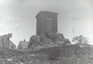
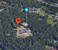
| A navigational aid for pilots flying into Hanscom Field airport in Bedford, Mass. is a radio beacon on top of Zion Hill in Woburn. For pilots, the location is known as the Shaker Hill NDB (non-directional beacon). For everyone else, and on all atlases and topographic maps where it’s labeled, the summit has always been Zion Hill. The reference to the Shakers does have an historical origin. Nathan Kendall (1723-1794) lived on Mill Brook (today’s Shaker Glen Brook). He was a descendant of Francis Kendall (1620-1708), one of earliest settlers of Woburn. Nathan and his wife Sarah White (1730-?), described as wealthy and prominent citizens of the town, gave up that lifestyle for the simple gifts of the Shakers after a visit in 1781 from Ann Lee (1736-1784), the founder of the sect in the United States. Local residents were suspicious of the Shakers and passed a petition to, “Exterminate a Meeting of Quakers... whose Conduct (if Reports are true) is contrary to the Laws of God & of this Commonwealth.” In 1790 the Kendall family left for Shaker communities in Harvard, Mass. and Mount Lebanon, N.Y. One of their daughter Hannah Kendall (1760-1816) stayed active in the Shaker community, and as sect dictated, never married. Nathan and Sarah’s youngest son Paul Kendall (1775-1825) did not follow the sect instead getting married and moving to Providence, R.I., where he started the Kendall Mfg. Co. They made soap and candle products from whale blubber. While Zion Hill, or Mount Zion, is a fairly common name, Hingham and Medford each have one, the name given to the hill in Woburn in the mid-1850s seems particulary relevant. |
|
|
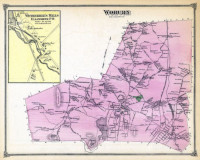
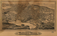
| Woburn Maps |
| • |
Woburn - Google Maps, Terrain |
| • |
Woburn - MassMapper MassGIS |
| • |
Woburn - USGS - The National Map |
| • |
Boston North Quadrangle - 2018 (60 MB PDF) - USGS Topo Download |
| • |
Lexington Quadrangle - 2018 (60 MB PDF) - USGS Topo Download |
| • |
Reading Quadrangle - 2018 (60 MB PDF) - USGS Topo Download |
| • |
Wilmington Quadrangle - 2018 (60 MB PDF) - USGS Topo Download |
| • |
Woburn Maps - Woburn Maps |
| • |
1875 Atlas of Woburn, published by G. M. Hopkins, 1875 - State Library of Massachusetts |
| • |
Woburn Maps: 17, 18, 19, 20, 21, 22, 23, 24, 25, Atlas of Middlesex County, Volume 2, published by Geo. W. Walker & Co., 1906 - State Library of Massachusetts |
| • |
Map of Middlesex County, Massachusetts, Henry F. Walling, 1856 - Norman B. Leventhal Map Center | Library of Congress |
| • |
Atlas of the Boundaries of the City of Woburn, Middlesex County, 1899 - State Library of Massachusetts |
|
|
| Woburn Sources |
| • |
The History of Woburn, Middlesex County, Mass., from the Grant of Its Territory to Charlestown, in 1640, to the Year 1860, Samuel Sewall, 1860 - Internet Archive |
| • |
1642-1892: Legends of Woburn, Vol. 1, Vol. 2, Parker L. Converse, 1892, 1896 - HathiTrust | Internet Archive, Vol. 1, Vol. 2 |
| • |
Proceedings, October Second to Seventh, 1892, at the Two Hundred and Fiftieth Anniversary of the Incorporation of the Town of Woburn, Massachusetts, 1893 - HathiTrust | Google ebooks |
| • |
Woburn, History of Middlesex County, Massachusetts: Containing Carefully Prepared Histories of Every City and Town in the County, George M. Champney. Samuel A. Drake, 1880, Vol. 2 - Internet Archive |
| • |
The Winchester Record, Vol. 1-3, Winchester Historical and Genealogical Society, 1885-1887 - HathiTrust |
| • |
Wobun, History of Middlesex County, Massachusetts, with Biographical Sketches of Many of its Pioneers and Prominent Men, William R. Cutter, Duane Hurd, 1890, Vol. 1 - Internet Archive |
| • |
Woburn Historic Sites and Old Houses, William R. Cutter, 1892 - Internet Archive |
| • |
Walks and Rides in the Country Round about Boston, Edwin M. Bacon, 1897 - Internet Archive |
| • |
List of Accepted Streets in Woburn, Mass. 1898 (PDF) - City of Woburn |
| • |
Woburn, Edison Electric Illuminating Co., 1909 - Internet Archive |
| • |
Woburn, Massachusetts, Allan Forbes, Towns of New England and old England, Ireland and Scotland, pg. 214, 1920 - HathiTrust | Internet Archive |
| • |
Woburn, Massachusetts, Towns of New England and old England, Ireland and Scotland, Vol. 2, pg. 214, State Street Bank, 1921 - HathiTrust |
| • |
A History of Woburn, Massachusetts Adapted for Use in the Junior High School (PDF), Patricia Ann Deehan, 1950 - OpenBU, Boston University |
| • |
Woburn, Hidden Tales of a Tannery Town, Maria Coady, 2008 - Google ebook preview |
| • |
Woburn, Images of America, Kathleen M. O'Doherty, 2000 - Google ebook preview |
| • |
Woburn Vision 2020 Community Development Plan (PDF), 2005 - Metropolitan Area Planning Council |
| • |
Woburn, MHC Reconnaissance Survey Town Report (PDF), 1980 - Massachusetts Historical Commission |
| • |
A Chronological History of Woburn, Massachusetts - Woburn Public Library |
| • |
A Vision for Mary Cummings Park (PDF), 2012 - The Friends of the Mary Cummings Park |
| • |
Woburn Open Space and Recreation Plan (PDF), 2004 - Metropolitan Area Planning Council |
| • |
Western Woburn Greenway Study, Jack Ahern, 2010 - Scholar Works, UMass Amherst |
| • |
History - City of Woburn |
| • |
Digital Collections - Woburn Public Library |
| • |
The Grand Affair : The Celebration of Woburn's 250th Anniversary of Incorporation, Dr. Thomas J. Glennon Archives - Woburn Public Library |
| • |
Woburn Historical Society |
| • |
Woburn Residents' Environmental Network (WREN) |
| • |
Waterfield (PDF), Ellen Knight, 2018 - Winchester Historical Society |
|
|
| |
|