| Hills of Wakefield, Mass. |
| | Hills | More about Wakefield's USGS-listed hills | Maps | Sources | |
| Academy Hill |
| • |
Google Maps | Google Earth - Google |
| • |
Academy Hill (Internet Archive): "...Academy Hill is the historic name for the small hill immediately to the east of Wakefield Square, between Main Street and Vernon Street. The northern part of the hill centered on the intersection of Salem and Pleasant Streets was once known as Fitch's Hill after the first owner of the lands on either side of Salem Street (then called Fitch's Lane). Academy Hill gets its name from the South Reading Academy, built in 1828-1829 on the site where the Lincoln School now stands...." - Lucius Beebe Memorial Library |
|
| Boyntons Hill |
|
| Candle Hill |
| • |
USGS identified - MassMapper MassGIS |
| • |
Google Maps | Google Earth - Google |
| • |
"...Candle Hill. This station is situated in the extreme southern part of Wakefield on the summit of a hill by that name, which is on the westerly side of Main street about 1 mile from Melrose town hall...", Atlas of the Boundries of the Town of Stoneham, Sheet 3, Topographical Survey Commission Commonwealth of Massachusetts, 1899 - State Library of Massachusetts |
| • |
Also called: "...1925. Tamworth Hill home building development started..." Eaton, pg 81, 1944 - Internet Archive |
| • |
Candle Hill - USGS Geographic Names Information System |
|
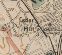
| Cedar Hill |
| • |
Google Maps | Google Earth - Google |
| • |
"...The principal elevations are Cowdrey's Hill, Cedar Hill, Hart's Hill, Prospect Hill, Castle Rock (just over the Wakefield-Saugus line) and Tudor's Hill..." Eaton, pg 14 , 1885 - Internet Archive |
| • |
Atlas of Massachusetts, Geo. H. Walker, 1891 - USGS Historical Topographic Map Explorer / MapJunction |
|
| Cowdry Hill |
|
| Cowdry Hill (historic) |
| • |
Google Maps | Google Earth - Google |
| • |
"...Dea. Cowdrey did not long remain on this location, but in a few years removed to what is now known as " Cowdrey's Hill......", Wakefield Souvenir of the Celebration of the 250th anniversary, 1894 - Internet Archive |
| • |
"...Toward the east we pass over Cowdrey's Hill, so-called from a son of William Cowdrey, an early settler, who had his homestead there...On the brow of the hill look down over the lake, not, as now, obscured by the railway, the ice houses, the gas house, which add no beauty to the landscap...", Wadlin, pg. 8, 1920s - Internet Archive |
| • |
First settlers homesteads: "...William Cowdrey (northern side of Prospect Street and east of Parker Road)...." - Lucius Beebe Memorial Library, NOBLE Digital Heritage |
| • |
First Settlers: "..William Cowdrey (1602-1687), a lawyer and the best educated of the settlers was undoubtedly the most politically and socially active of the first settlers...." - Lucius Beebe Memorial Library, NOBLE Digital Heritage |
|
| Crescent Hill |
|
| Golden Hills |
| • |
Google Maps | Google Earth - Google |
| • |
"...1933 - That part of Saugus known as 'Golden Hills' annexed to Wakefield..." Eaton, pg 83 , 1944 - Internet Archive |
| • |
Golden Hills,"...The approximately 500 acres of the Golden Hills ACEC contain an unusual blend of residential and ecological resources within the heavily urbanized Boston metropolitan area...Bedrock outcrops, or ledges, are prevalent throughout the area, especially in hilly sections...." - Office of Energy and Environmental Affairs, Commonwealth of Massachusetts |
|
| Greenwood Hill |
| • |
USGS identified - MassMapper MassGIS |
| • |
Google Maps | Google Earth - Google |
| • |
"...[Deacon Daniel Green}... We know, from Stoneham records, that about that time he removed from Stoneham to South
Reading, just over the line... The locality has within a few years received the name of Greenwood, we suppose from respect to him and his family. The Boston and Maine Railroad now passes through the place, and the cars stop many times a day at the "Greenwood Railroad Station." It is close upon the borders of Stoneham ; and some of the Stoneham people are accommodated by it...", A Genealogical Sketch of the Descendants of Thomas Green[e] of Malden, Mass., pg. 42, Samuel S. Greene, 1858 - Internet Archive |
| • |
Green - Brown - White House, "...The Green family was among the early settlers of South Reading, arriving before 1700. They settled south of Crystal Lake in the area which later came to be known as Greenwood. This part of town had belonged to Maiden until it was annexed by Reading in 1729..." - Massachusetts Historical Commission Information System (MACRIS) |
| • |
Capt. William Green House, "...At one time the Green property included nearly 30 acres of land on the west side of Vernon Street as well as about 10 acres on the side on which the house is situated..." - Massachusetts Historical Commission Information System (MACRIS) |
| • |
Dea. Daniel Green House, "...The Green family as a whole came to South Reading before 1700 and settled in this area south of Crystal Lake, called then Smith's Pond, an area which came to be known as Greenwood..." - Massachusetts Historical Commission Information System (MACRIS) |
| • |
"...The highest points are Harts Hill, which is 230 feet above mean sea level (MSL); Greenwood Hill, which is about 250 feet above MSL..." Wakefield Open Space and Recreation Plan (PDF), pg. 23, 2004 - Metropolitan Area Planning Council |
| • |
Greenwood Hill - USGS Geographic Names Information System |
|
| Harts Hill |
| • |
USGS identified - MassMapper MassGIS Online |
| • |
Google Maps | Google Earth - Google |
| • |
"...The view from Hart's Hill at Wakefield Junction, looking westward, is said to excel many world-renowned sights which are seen in the European World..." Eaton, pg 74 , 1885 - Internet Archive |
| • |
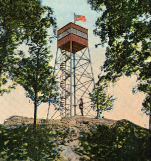
Hart's Hill Tower : "...Postcard shows the Hart's Hill forest fire watch tower built at the summit of Hart's Hill in 1913 by the state Forestry Department....." - Lucius Beebe Memorial Library, NOBLE Digital Heritage |
| • |
History of the Hartshore House: "...Between 1792 and 1802, the house was owned by the locally famous Dr. John Hart. The doctor, for whom Hart’s Hill was named, was a Revolutionary War surgeon of considerable renown — he was closely affiliated with George Washington...." - Wakefield Historical Society |
| • |
"...He was a surgeon in the Army of the Revolution, and had, I think, a personal acquaintance with
General Washington...", Wakefield Souvenir of the Celebration of the 250th anniversary, 1894 - Internet Archive |
| • |
Dr John Hart, "...For more than fifty years he was a well-known and esteemed physician in that part
of Reading which is now Wakefield, Mass., his practise being widely extended. He was much interested in all public matters, political, local, or general. He was elected eight times to the House of Representatives, and five times to the Senate of Massachusetts. He was a justice of the peace and of the quorum, and also of the Court of Sessions , was school committee and selectman of the town of Reading,,,:", Proceedings of the 250th Anniversary of the Ancient town of Redding, pg. 366, Chester W. Eaton, Warren E. Eaton, William E. Eaton, 1896 - HathiTrust |
| • |
"...Hart's Hill is named for Dr. John Hart..." Eaton, pg 257 , 1944 - Internet Archive |
| • |
Dr. John Hart House, "...After the war he came to South Reading and was prominent in the town from 1790-1830. Townspeople called him 'the King' for his strong personality and influence in town affairs..." - Massachusetts Historical Commission Information System (MACRIS) |
| • |
Harts Hill - USGS Geographic Names Information System |
|
| Rattlesnake Hill |
|
| Shingle Hill |
| • |
Google Maps | Google Earth - Google |
| • |
"...The hill at the intersection of Salem and Pleasant Streets has long been known as 'Shingle Hill'..." Eaton, pg 259, 1944 - Internet Archive |
| • |
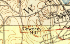
"...is located on the terrace plain between Wakefield's two lakes and extends up the slopes of Shingle Hill to the east and Cowdry's Hill to the west...." Wakefield Multiple Resource Area (PDF), 1989 - National Park Service |
|
| Round Hill |
|
| Tudors Hill |
|
| Wests Hill |
|
|
|
 |
|
 |
|
 |
|
 |
|
 |
|
 |
|
 |
|
 |
|
 |
|
| Candle Hill |
 |
|
 |
|
| Cowdrys Hill (historic) |
 |
|
 |
|
| Cedar Hill |
 |
|
| Greenwood Hill |
 |
|
| Harts Hill |
 |
|
 |
|
 |
|
| Tudors Hill |
 |
|
|
|
| More about Wakefield's USGS-listed hills |
|
Settlers moving inland established a place they called Lynn Village at the southern end on the large pond now called Lake Quannapowitt in 1638. In 1644 the area was incorpoated as the town of Reading. Today’s Wakefield split off from Reading in 1812 taking the name South Reading. In 1846 an effort was made to change the name of the town. A vote was held, and the name Winthrop received by far the largest support. But when thestate was petitioned to make the change, the Legislature refused to act on the request. Why Winthrop? That is not recorded. At the time Robert C. Winthrop (1809-1894), a descendant of John Winthrop, was a powerful political figure in the state. He had been elected a Massachusetts State Representative, then a U.S. State Representative, was soon to be Speaker of the House, and then a U.S. Senator. It’s not clear why the name change was not accepted. In that same year, 1846, the town that would become Winthrop was part of North Chelsea when it split off from Chelsea. It wouldn’t be until 1852 that the Pullen Poynt/Chelsea Point area would spilt off and become Winthrop. Possibly the Legislature felt that because Deane Winthrop (1623-1704), one of John Winthrop’s sons, had lived in Pullen Poynt, that town should have the right to claim the name. The idea of a name change would not come up again until after the Civil War. |
|
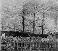
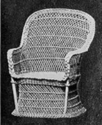
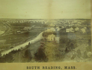
In 1868 the South Reading voted to change its name to Wakefield to honor local businessman and philanthropist Cyrus Wakefield (1811-1873).2 The Wakefield Historical Society excerpts a 1994 book by Nancy Bertrand, Wakefield: 350 Years by the Lake, and describes Wakefield saying, his life was a “rag-to-riches” story of "...a poor New Hampshire farm boy who built a part-time industrial refuse business into no less than four multi-million-dollar empires, in East Indies spices, Boston real estate, railroads, and the rattan goods business..." Starting by using discarded bundles of rattan found on the docks of Boston, Wakefield would originate and then dominate the wicker furniture business in the United States. At its peak, his manufacturing plants and warehouses covered ten acres in South Reading and employed over a thousand men and women. This, along with his gift of the land and money to build a new Town Hall with a Civil War Memorial, convinced the towns people to rename their town in his honor. Along with the rattan furniture business, Wakefield was one of the so-called Merchant Princes of Boston. He would be the owner of the cargo on a fleet of ships carrying rattan, pepper, tin, sugar, coffee, and spices traveling between the East Indies and New England; on the Board of Directors of the Boston and Maine Railroad; and one of a consortium of businessmen who founded the Boston Globe. |
|
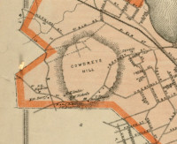
Wakefield has six USGS-listed hills, three of which are named for families. Cowdry Hill (184 ft.) is named for William Cowdrey (1602-1687). He is said to have immigrated to New England in 1630, the same year that John Winthrop arrived at the head of the Puritan migration. Cowdrey did not follow Winthrop to Boston instead settling in Lynn. In 1640 he is one of group of men who received land in Lynn Village, this before it became Reading, or Wakefield. A lawyer and the best educated of the settlers he had a major role in shaping the early policies, rules and regulations, having served as Clerk of Writs, Deacon of the Church, Alcoholic Commissioners, Town Clerk, Selectman, Representative to the General Court and Justice of the Peace. The location of Cowdry Hill is very accurately described in the historic record and is shown on many maps. It appears on the 1893 USGS topographic map, but then is not labelled on any of the newer USGS maps up until it reappears in the latest National Map, in a different place. The citation in the USGS-GNIS record does not reference a geological survey, like with more than a few other hills on the northern rim of the Boston Basin with questionable locations, it’s Aden T. Vaughan and his 1965 book, which doesn’t mention the hill. And there might be a problem with another Vaughan-located hill in Wakefield, Round Hill (138 ft.). In none of the historic writings about Wakefield is Round Hill mentioned. On the other hand, in next-door Saugus there is documented evidence of Native American presence at what is known as Round Hill. |
| Boyntons Hill (253 ft.), and the Boyntonville neighborhood, is named for family that live in the area in the late 1800s. The Boynton name in America dates back to a William Boynton (1605-1672) who immigrated in 1638. He was likely in the group that first settled Rowley, Mass., but there is no information other than a last name that links that Boynton to the Boynton’s of Wakefield. A 1924 obituary for Sarah H. Boynton, age 93, says she and her husband Charles S. Boynton were “pioneer residents of Greenwood” in Wakefield.3 It appears that the people of Boyntonville in the late 1800s, located well south of Wakefield center, were not content with the “facilities and accommodations” they were receiving from town officials. Newspaper articles and town reports from the time record an effort by the citizens of the neighborhood to split off from Wakefield and join Melrose. It never happened possibly because Melrose was less than enthused about the idea. Boyntons Hill is not mentioned in the early histories of the town, and it is possible that it was given its name during surveys conducted by the Massachusetts Board of Harbor and Land Commission in the very early 1900s. Their Atlas of Boundaries for Wakefield used the hill as a triangulation station and would have needed a name. |
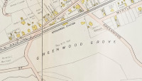
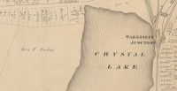
| The name of USGS-listed Greenwood Hill (239 ft.), located on the southern edge of Crystal Lake, is attributed to Daniel Green (1733-1818) who moved with his family from nearby Stoneham to South Reading in 1785, and then quickly petitioned that his land be annexed to Stoneham. That didn’t happen but it does given an indication how fluid town borders were. Daniel was the fifth-generation descendant of Thomas Green (c. 1606-1667) who had immigrated around 1636 and settled in the northern part of Malden, now Melrose. There were numerous related Greens living in the area, and there were numerous unrelated Greens, including Henry Green (1618-1648) who was the first minister of South Reading. Along with Greenwood Hill, the nearby neighborhood is also called Greenwood, and it’s the name of the railroad station opened on the new line in 1850. Early maps label the area Greenwood Grove, and it is possible that the hill only received its name after the railroad company named their station. |
|
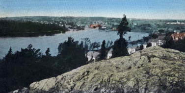
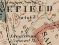
Located on the eastern side of Crystal Lake is USGS-listed Harts Hill (230 ft.). It was named for John Hart (1751-1836), born in Ipswich, Mass., he studied to be a doctor and served as a surgeon during the Revolutionary War.4 After the war he married Mary Gould (1753-1838) and settled in South Reading. There is practiced medicine for more than fifty years and served in multiple local and states political roles. He was elected eight times to the House of Representatives, and five times to the Senate of Massachusetts. Over his life he also served as a justice of the peace, town selectman, and school committee member. Though not the summit of Harts Hill, much of the area around the hill, and the land around nearby Crystal Lake, has been preserved thanks to John J. Round (1872-1958), a major benefactor to the town.5 A Boston jeweler, he was very active in local affairs, and generous in donations of land and trees to the town. Much of Harts Hill is in the John J. Round Park. |
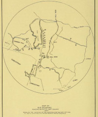
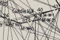
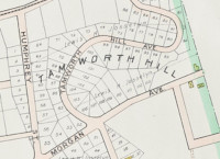
| How USGS-listed Candle Hill (200 ft.) was named is not clear. The hill is identified with that name as a triangulation station in the early 1900’s Atlas of Boundaries survey. But in 1896 its called Tamworth Hill in a short article in the Boston Globe announcing, “one of the largest sales of vacant land that has taken place in a long time.” There is a Candle in West Roxbury, its name supposedly derived from stories told by the early settlers of seeing lighted candles at night on the hill. In Scotland there are several Candle Hills, all containing large stones, possibly megalithic in origin. Tamworth, N.H. was named to honor a British nobleman. |
|
|
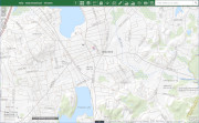
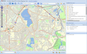
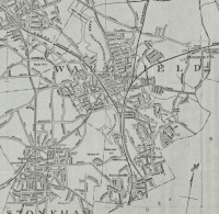
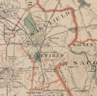
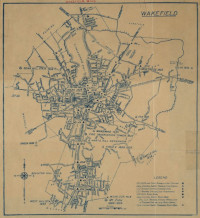
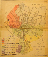
| Wakefield Maps |
| • |
Wakefield - Google Maps, Terrain |
| • |
Wakefield - MassMapper MassGIS |
| • |
Wakefield - USGS - The National Map |
| • |
Boston North Quadrangle - 2018 (60 MB PDF) - USGS Topo Download |
| • |
Reading Quadrangle - 2018 (60 MB PDF) - USGS Topo Download |
| • |
1890 Topographicsl Atlas of Massachusetts,
Boston Sheet - Library of Congress, David Rumsey
Lawrence Sheet - Library of Congress, David Rumsey |
| • |
South Reading as it was: 1750 - Lucius Beebe Memorial Library Historic Maps, Digital Commonwealth |
| • |
Facsimile of Col. Nichols' plan of the First Parish of Reading, the present towns of Wakefield and Reading, plotted in 1765 - Lucius Beebe Memorial Library Historic Maps, Digital Commonwealth |
| • |
A plan of South Reading in the County of Middlesex, 1830 - Lucius Beebe Memorial Library Historic Maps, Digital Commonwealth |
| • |
Wakefield, George H. Walker & Co., 1874 - Lucius Beebe Memorial Library, Norman B. Leventhal Map Center |
| • |
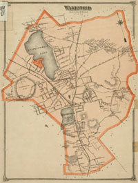
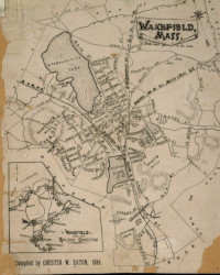
Wakefield, Chester W. Eaton, 1889 - Lucius Beebe Memorial Library Historic Maps, Digital Commonwealth |
| • |
Atlas of Massachusetts, Geo. H. Walker, 1891 - USGS Historical Topographic Map Explorer / MapJunction |
| • |
Wakefield Maps: 12, 13, 14, 15, Atlas of Middlesex County, Vol. 2, Geo. W. Walker & Co., 1906 - State Library of Massachusetts |
| • |
Map of the towns of Wakefield, Stoneham, Reading, North Reading, and Lynnfield, H.T. Whitman, 1907 Norman B. Leventhal Map Center, Boston Public Library |
| • |
Wakefield, U.S. Coast and Geodetic Survey, 1936 - Lucius Beebe Memorial Library Historic Maps, Norman B. Leventhal Map Center |
| • |
Wakefield Maps & Images - Lucius Beebe Memorial Library |
| • |
Atlas of the boundaries of the city of Lynn and towns of Nahant, Saugus, and Swampscott, Essex County and Wakefield, Middlesex County, 1902 - State Library of Massachusetts |
|
|
| Wakefield Sources |
| • |
Hand-Book of Wakefield, Mass., Will E. Eaton, 1885 - Internet Archive |
| • |
Wakefield Souvenir of the Celebration of the 250th anniversary of ancient Reading, 1894 - Internet Archive |
| • |
Proceedings of the 250th Anniversary of the Ancient town of Redding, once including the Territory now Comprising the Towns of Reading, Wakefield, and North Reading, Chester W. Eaton, Warren E. Eaton, William E. Eaton, 1896 - Internet Archive / HathiTrust |
| • |
Wakefield, History of Middlesex County, Massachusetts, with Biographical Sketches of Many of its Pioneers and Prominent Men, Duane Hurd, 1890, Vol. 2 - Internet Archive |
| • |
Wakefield, History of Middlesex County, Massachusetts: Containing Carefully Prepared Histories of Every City and Town in the County, Samuel A. Drake, 1880, Vol. 2 - Internet Archive |
| • |
Concerning the Past, Horace G. Wadlin, 1920s - Internet Archive |
| • |
Geology of Wakefield, Massachusetts, Ernest E. Fairbanks, 1922 - Internet Archive |
| • |
History of Wakefield (Middlesex County) Massachusetts, William E. Eaton, 1944 - Internet Archive |
| • |
Ancient Redding in Massachusetts Bay Colony, Loea P. Howard, 1944 - Internet Archive |
| • |
Wakefield, MHC Reconnaissance Survey Town Report (PDF), 1980 - Massachusetts Historical Commission |
| • |
Wakefield Multiple Resource Area (PDF), 1989 - National Park Service |
| • |
Wakefield Open Space and Recreation Plan (PDF), 2004 - Metropolitan Area Planning Council |
| • |
Wakefield, Images of America, Betsy J. Cutter - Google ebook preview |
| • |
Wakefield Revisited, Images of America, Nancy Bertand, 2010 - Google ebook preview |
| • |
Lucius Beebe Memorial Library |
| • |
Lucius Beebe Memorial Library Photostream - Flickr |
| • |
Wakefield Historical Society |
| • |
Wakefield Historical Society News |
| • |
Nancy Bertand Columns - Wakefield Patch |
| • |
Digitized Books on Reading History - Reading Public Library |
|
|
| Footnotes |
| 1 |
Wakefield's Early Identity Crisis, or the Town of South Reading, Nancy Bertrand, 2011 - Wakefield Patch |
| |
Chronicle/What's in a Name: A Local Town's Identity Crisis, 2016 - WCVB |
| 2 |
The Remarkable Mr. Wakefield, Jim Wulff, excerpted from Wakefield: 350 Years by the Lake, 1994 - Wakefield Historical Society |
|
The Remarkable Cyrus Wakefield, John Wall, 2013 - Mark Sardella |
|
The Wakefield Rattan Company, John Wall, excerpted from Wakefield: 350 Years by the Lake, 1994 - Town of Wakefield |
|
Wakefield Rattan Company, In Pursuit of Beauty, Dictionary of Architects, Artisans, Artists and Manufacturers, pg. 478, Catherine H. Voorsanger, Metropolitan Museum of Art, 1986 - Google ebook |
|
The Merchant Princes, Cyrus Wakefield and George Peabody, Helen Breen, 2016 - Historic Ipswich |
|
A Completed Century, 1826-1926; the Story of Heywood-Wakefield Company, 1926 - Internet Archive |
| 3 |
Mrs Sarah H. Boynton of Wakefield Dead (Subscription), 1924 - Boston Globe |
| 4 |
Revolutionary War Doctor John Hart , Nancy Bertrand, 2012 - Wakefield Patch |
| 5 |
John J. Hart, The Jewelers' Circular, Vol. 85, pg. 113, 1922 - Google ebook |
|
|