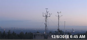
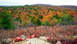
| Hills of the Blue Hills Reservation, Mass. |
| | Introduction | Hills | Maps | Sources | |
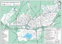
| "The Blue Hills Reservation forms a public domain of 3.953 acres. It was taken by the Metropolitan Park Commission in the autumn of 1893, a few months after the passage of the law establishing that board with the authority to lay out public open spaces in the Metropolitan Parks District. It is the largest of the several public reservations and parks in the metropolitan district, and the largest recreation ground possessed by any American city. It comprises nearly the entire range of the Blue Hills, and lies within the limits of the towns of Milton and Canton, and the city of Quincy. It is a diversilied tract of hills and woodland, and the greater portion of the region has a mountain-like character, which gives the reservation its distinctive charm." Read all > > |
|
| Hills of the Blue Hills Reservation, Mass. |
| Babel Rock - Quincy |
| • |
USGS identified - MassMapper MassGIS |
| • |
Google Maps | Google Earth - Google |
| • |
"...A granite boulder twenty feet long lies on the north side of the carriage road south of Rattlesnake Hill, and another fifty six feet in circumference and eight feet high, rests upon the summit of Babel Rock, northeast of Rattlesnake Hill...",Geology of the Boston Basin: The Blue Hill Complex, William Otis Crosby, Vol. 1, Part 3, pg. 556, 1900 - Google ebook |
| • |
Babel Rock, Map of the city of Quincy, Norfolk County, Massachusetts, Ernest W. Branch, Civil Engineer, 1907 - Norman B. Leventhal Map Center, Boston Public Library |
| • |
Babel Rock - USGS Geographic Names Information System |
|
| Boyce Hill - Quincy |
| • |
USGS identified - MassMapper MassGIS |
| • |
Google Maps | Google Earth - Google |
| • |
South Boyce Hill, Blue Hills Reservation Trail Map (PDF) - State of Massachusetts |
| • |
Names of the Blue Hills, "...I found a nameless summit, 400 feet, not shown on any map till mine, and overlooked by the surveyors for the recent official map of the State. An old resident of Milton suggested a name I spelled Boyce. It probably should be Boies...". E.G. Chamberlain, Boston Transcript, June 4, 1895 - Google News Archives |
| • |
"...James Boies was recognized as a faithful citizen and earnest patriot a prominent manufacturer and a projector of many valuable enterprises...Mr. Boies was born in Ireland in 1702 and died in Milton, Mass. July 11, 1798 at the advanced age of ninety six years...Mr. Boies was interested in paper mills and the manufacture of paper as early as 1760...Boies may be said to be the founders and early promoters of the paper industry of Dorchester...". The Irish in the American Revolution and theor Early Influence in the Colonies, James Haltigan, pg. 296, 1908 - Google ebook |
| • |
Boyce Hill - USGS Geographic Names Information System |
|
| Breakneck Ledge - Milton |
|
| Breeze Hill - Milton |
|
| Buck Hill - Quincy |
| • |
USGS identified - MassMapper MassGIS |
| • |
Google Maps | Google Earth - Google |
| • |
Blue Hills Reservation Trail Map (PDF) - State of Massachusetts |
| • |
Names of the Blue Hills, "...Northeast of Boies is one of the principal summits of the range, 495 feet, known far and near as Bear Hill, and so designated on most maps, and about the only summit correctly located thereon. A resident of Canton told me the true name was Buck Hill. Now I preferred Buck to bear, the latter name is so common. But with the old maps before me giving Bear in plain print on the only summit except Blue that was named at all, I did not feel authorized to substitute Buck. I do not object to the change to Buck now of the park map...". E.G. Chamberlain, Boston Transcript, June 4, 1895 - Google News Archives |
| • |
Buck Hill - USGS Geographic Names Information System
Variant name: Bear Hill |
|
| Burnt Hill - Quincy |
| • |
USGS identified - MassMapper MassGIS |
| • |
Google Maps | Google Earth - Google |
| • |
"...This old cellar marks the house in the woods built early in the present century by Bugbee, keeper of a tavern in Roxbury, who owned a part of Burnt Hill, and it is the site, perhaps, of a former house built by an earlier Bugbee during the Revolution as a retreat from the British. ...", Bacon, pg. 349, 1897 - Google ebook |
| • |
Blue Hills Reservation Trail Map (PDF) - State of Massachusetts |
| • |
Burnt Hill - USGS Geographic Names Information System |
|
| Chickatawbut Hill - Quincy |
| • |
USGS identified - MassMapper MassGIS |
| • |
Google Maps | Google Earth - Google |
| • |
Blue Hills Reservation Trail Map (PDF) - State of Massachusetts |
| • |
Names of the Blue Hills, "...North of the Glover place, I found a hill which I proved to the second in height of the Blue Hills, 518 feet. It was called Fenno Hill by some of the neighbors, a name also applied to the next summit northeast, 483 feet. To distinguish them, I called the higher one Fenno Peak. After the map went to press, I learned too late that the Fenno estate did not include the higher summit, and I immediately renamed it Chickataubut...Northeast is the trure Fenno Hill, which the recent maps call Nahanton....". E.G. Chamberlain, Boston Transcript, June 4, 1895 - Google News Archives |
| • |
"..This is sometimes called Swan's Hill and Fenno's Hill, but really has no fixed name. How fitting that this hill henceforth bear the name of Chickataubut Hill, a late, but just tribute to the memory of that illustrious chief, and his
departed race...", Teele, pg. 78, 1887 - Internet Archive |
| • |
Researched Meaning of Some Local Native American Names (PDF), "...In the early 1620s, Chickataubut, Sachem of the Massachusetts, moved from Passonageset, in the area of Merrymount, Quincy Shore Drive and Sea Street, with abou sixty of his followers who had survived the 1618 plague to Moswetuset Hummock...", George R. Horner, Quincy History Society Newsletters, 1989 - Thomas Crane Public Library |
| • |
Chickatawbut Hill - USGS Geographic Names Information System
Variant names: Chickabut Hill, Chickataubut Hill |
|
| Fox Hill - Quincy |
|
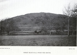
| Great Blue Hill - Milton |
| • |
USGS identified - MassMapper MassGIS |
| • |
Google Maps | Google Earth - Google |
| • |
Blue Hills Reservation Trail Map (PDF) - State of Massachusetts |
| • |
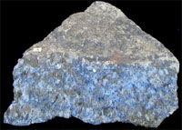
Great Blue Hill, "...The modern name for the hill was given by early European explorers who, while sailing along the coastline, noticed the bluish hue of the exposed granite faces when viewed from a distance (due to Riebeckite)..." - Wikipedia |
| • |
The Hard Truth: The Geology of the Blue Hills (PDF), "...Within the western part of the Reservation, the magma cooled more rapidly giving the minerals lesser time to crystallize. The two sections of the Reservation appear to have formed from the same body of emplaced magma, which means that they share the same mix of minerals. Both rocks, for example, contain the mineral riebeckite, which gives both sections of the Blue Hills its bluish color...." - Friends of the Blue Hills |
| • |
Names of the Blue Hills, "...In a military order, dated Sept. 7, 1778, General Heath requestsa detail of eight men from the Milton or Stoughton militia to attend the beacon just completed on 'Great Blue Hill.'...". E.G. Chamberlain, Boston Transcript, June 4, 1895 - Google News |
| • |
Riebeckite, "...[Riebeckite] was first described in 1888 for an occurrence on Socotra Island, Aden Governorate, Yemen and named for German explorer Emil Riebeck (1853–1885)..." - Wikipedia |
| • |
Obituary: Dr. Emil Riebeck, "...By the death of his father a few years ago the deceased came into possession of a considerable fortune and he determined to employ some of his ample means in the furtherance of anthropological and geographical research....", Proceedings of the Royal Geographical Society and Monthly Record of Geography, Volume 7, pg. 545, 1885 - Google ebook |
| • |
Great Blue Hill - USGS Geographic Names Information System
Variant Names: Big Blue Mountain, Blue Hill, The Blue Hill |
|
| Great Dome - Quincy |
|
| Hancock Hill - Milton |
| • |
USGS identified - MassMapper MassGIS |
| • |
Google Maps | Google Earth - Google |
| • |
Blue Hills Reservation Trail Map (PDF) - State of Massachusetts |
| • |
Names of the Blue Hills, "...The elevated basin west of the summit was known as Hancock Valley, and a lot of the eastern slope had been deeded as the Hancock orchard. So I named the intervening summit Hancock. I afterward learned it had been the property of Governor Hancock and found two old gentleman who had known it by that name..". E.G. Chamberlain, Boston Transcript, June 4, 1895 - Google News |
| • |
"...In the winter of 1780, which was intensely cold, causing great suffering among the destitute in Boston, the harbor and the water approaches being frozen over, John Hancock had a large quantity of wood cut from his lot in Milton, probably this hill, and sledded down the river and over the ice
to Boston, for gratuitous distribution among the poor...", Teele, pg. 69, 1887 - HathiTrust |
| • |
Hancock Hill - USGS Geographic Names Information System |
|
| Hawk Hill - Quincy |
|
| Hemenway Hill - Milton |
| • |
USGS identified - MassMapper MassGIS |
| • |
Google Maps | Google Earth - Google |
| • |
Blue Hills Reservation Trail Map (PDF) - State of Massachusetts |
| • |
The Blue Hill Names, "...The two spurs I called West and South Hancock on the Milton Map. The Park Commission has appropriately named the former Hemenway Hill...", Boston Transcript, June 4, 1895 - Google News |
| • |
"...Augustus Hemenway, Son of Augustus and Mary (Tileston) Hemenway born in Boston Oct. 10, 1853....Since graduation has resided in Milton, Mass., and on his farm in Canton, Mass. during the summer, and in Boston during the winter months...In 1890 and 1891 represented Milton and Canton in the Massachusetts Legislature, and in 1895 was appointed a member of the Metropolitan Park Commission...", Harvard College Secretary's Report, Issue 7, 1875-1899, pg. 53 - Gooogle ebook |
| • |
Augustus Hemenway, "...He supported a number of other institutions in the Boston area, including the Museum of Fine Arts, Massachusetts Eye and Ear Infirmary, Groton School, Metropolitan Park Commission, and MIT...Hemenway married Harriet Lawrence. She became the cofounder of the initial Audubon Society; the Massachusetts Audubon Society..." - Wikipedia |
| • |
History of Ponkapoag Camp, "...On one of his off-season visits to the pond he saw a lone skater approaching the shore, Hailing the stranger, Will explained to him the desirability of having all of the land bordering the pond brought into the reservation. The skater happened to be Mr. Augustus Hemenway, owner of a parcel of land bordering the pond. As a result of Mr. Roger’s eloquence, Mr. Hemenway offered not only to give his own land, assessed at $21,500, to the Reservation, but to do his best in the way of persuading the other land owners to give their..." - Appalachian Mountain Club |
| • |
West Hancock Hill, Blue Hills Reservation; Massachusetts, E.G. Chamberlain,1885 - Olmstead Archives |
| • |
Hemenway Hill - USGS Geographic Names Information System |
|
| Hole in Rock - Quincy |
|
| Houghton Hill - Milton |
| • |
USGS identified - MassMapper MassGIS |
| • |
Google Maps | Google Earth - Google |
| • |
"...Ralph Houghton was born in Lancaster, England, in 1623; died in Milton, Mass., April 15, 1705, aged 82 years...
...After the burning of Lancaster by the Indians, in 1675, and the massacre of a large number of its inhabitants, Ralph and John Houghton, who were away at the time, left with others and went tWoburn and Dorchester. Ralph removed later to Milton where he settled permanently...", The Houghton Family Genealogy (PDF), John W. Houghton, 1912 - Ian MacInnes, Albion College |
| • |
Blue Hills Reservation Trail Map (PDF) - State of Massachusetts |
| • |
The Blue Hill Names, "...On my second Appalachian map, I changed South Hancock to Houghton, although the Houghton estate does not quite include the summit...", Boston Transcript, June 4, 1895 - Google News |
| • |
Houghton Hill - USGS Geographic Names Information System |
|
| Kitchamakin Hill - Quincy |
| • |
USGS identified - MassMapper MassGIS |
| • |
Google Maps | Google Earth - Google |
| • |
Blue Hills Reservation Trail Map (PDF) - State of Massachusetts |
| • |
Names of the Blue Hills, "...The name Kitchamakin is really placed on the nameless eastern spur of Chickataubut. These two chiefs were brothers, and if Fenno is to be supplanted perhaps Kitchamakin would be more appropiate there.....". E.G. Chamberlain, Boston Transcript, June 4, 1895 - Google News Archives |
| • |
"...Chickataubut died of small-pox in 1633, leaving a family of young children. During the minority of his heirs Kitchamakin, his brother, was made chief of the tribe...He seems to have gathered the scattered remnants of the nation near the head of tide-waters, on the Neponset, and to have settled down in quiet subjection to the incoming people. In 1636 he deeded the whole territory of Unquity to Richard Collicot...", The History of Milton, Mass., Pg. 7, Albert K. Teele, 1887 - Internet Archive |
| • |
"...John Fenno, believed to be a son of Rebecca Fenno, was granted twenty acres of
land in Equity (Milton) in 1660, and soon afterward built a house there...The locality of his house long bore the name of Fenno Hill, recently changed by the Metropolitan park commission to Kitchamakin Hill...", Genealogical and Personal Memoirs Relating to the Families of Boston and Eastern Massachusetts, William R. Cutter, Vol. 4. pg. 1680, 1908 - HathiTrust |
| • |
Kitchamakin Hill - USGS Geographic Names Information System |
|
| Little Blue Hill - Canton |
| • |
USGS identified - MassMapper MassGIS |
| • |
Google Maps | Google Earth - Google |
| • |
Blue Hills Reservation Trail Map (PDF) - State of Massachusetts |
| • |
"...The Blue Hills are the highest land in eastern Massachusetts. The entire range is seven miles long, extending from Little Blue Hill in Canton, easterly to President's Hill in Quincy, embracing Hancock, Buck, Chicatawbut, and six other prominent peaks, all contained in the Reservation of 5,000 acres...", Stone & Webster Public Sevice Journal, Vol. 4, pg. 408, 1909 - Google ebook |
| • |
Little Blue Hill - USGS Geographic Names Information System |
|
| Little Dome - Quincy |
|
| Nahanton Hill - Quincy |
| • |
USGS identified - MassMapper MassGIS |
| • |
Google Maps | Google Earth - Google |
| • |
Blue Hills Reservation Trail Map (PDF) - State of Massachusetts |
| • |
Names of the Blue Hills, "...North of the Glover place, I found a hill which I proved to the second in height of the Blue Hills, 518 feet. It was called Fenno Hill by some of the neighbors, a name also applied to the next summit northeast, 483 feet. To distinguish them, I called the higher one Fenno Peak. After the map went to press, I learned too late that the Fenno estate did not include the higher summit, and I immediately renamed it Chickataubut...Northeast is the trure Fenno Hill, which the recent maps call Nahanton....". E.G. Chamberlain, Boston Transcript, June 4, 1895 - Google News Archives |
| • |
The Blue Hill Names, "...The change of Fenno's Hill to Nahanton Hill is a continuance of Mr. Chamberlain's idea of naming hills after Indian chiefs who once lived in the region...", Boston Transcript, June 4, 1895 - Google News Archives |
| • |
"...The facts of Nehoiden’s early life are not always clear. We are not even really sure of his name. There are 23 different transcriptions of his name in the state archives, most of them variations of “Hahaton” (as in Nahaton, Nahanton)...He was born sometime around 1635, in the village of Unquity (now Milton). He and is family were converted to Christianity by the Rev. John Eliot in the 1640s, and he took the Christian name of William – William Nehoiden. His family moved to the “Praying Indian” (Christian convert) village at Ponkapoag...", Happy Nehoiden Day!, Gloria Greis - Needham Historical Society |
| • |
Nahanton Hill - USGS Geographic Names Information System |
|
| North Boyce Hill - Quincy |
| • |
Google Maps | Google Earth - Google |
| • |
North Boyce Hill, Blue Hills Reservation Trail Map (PDF) - State of Massachusetts |
| • |
Names of the Blue Hills, "...I found a nameless summit, 400 feet, not shown on any map till mine, and overlooked by the surveyors for the recent official map of the State. An old resident of Milton suggested a name I spelled Boyce. It probably should be Boies...". E.G. Chamberlain, Boston Transcript, June 4, 1895 - Google News Archives |
|
| Rattlesnake Hill - Quincy |
| • |
USGS identified - MassMapper MassGIS |
| • |
Google Maps | Google Earth - Google |
| • |
Blue Hills Reservation Trail Map (PDF) - State of Massachusetts |
| • |
Names of the Blue Hills, "...The last prominent summit within the reservation, 314 feet, I found to be well known among the quarry men as Rattlesnake. From this hill, a spur projects westerly ending in a notable crage nearly as high as the main summit. Fancying the hill to resemble a snake coiled up, this craig answers for the rattle on the end of the tail, and I referred to it as Rattle Rock on our Appalachian walks, but the name has never appeared in print....". E.G. Chamberlain, Boston Transcript, June 4, 1895 - Google News Archives |
| • |
Rattlesnake Hill - USGS Geographic Names Information System |
|
| Slide Notch - Quincy |
|
| Southeast Ridge - Quincy |
|
| The Broken Hills - Quincy |
|
| The Crags - Quincy |
|
| Tucker Hill - Quincy |
| • |
USGS identified - MassMapper MassGIS |
| • |
Google Maps | Google Earth - Google |
| • |
Blue Hills Reservation Trail Map (PDF) - State of Massachusetts |
| • |
Names of the Blue Hills, "...In 1884, Rev. A.K. Teele engaged me for the togographical work of the History of Milton. He took me to the old [Ebenezer] Bugbee place and instructed me to use the name Bugbee on the historical map. I used this name on my Appalachia map also. The recent map calls it Tucker Hill...". E.G. Chamberlain, Boston Transcript, June 4, 1895 - Google News Archives |
| • |
Bugee's Hill, Blue Hills Reservation; Massachusetts, E.G. Chamberlain,1885 - Olmstead Archives, NHS, NPS |
| • |
Removing Landmark Names, "...Bugbee is now named Tucker. The former was well established, the old Bugbee place lying on its south side...", , Boston Transcript, May 25, 1895 - Google News Archives |
| • |
The Blue Hill Names, "...Bugbee hill is now called Tucker Hill because its summit was once owned by a man of that name. The hill to which the name Bugbee, according the Mr. Taylor, is one to the southeast not shown of Mr. Chamberlain’s map, on the whose western slope the old Bugbee well and cellar are situated..", Boston Transcript, June 4, 1895 - Google News Archives |
| • |
Samuel Tucker House, "...Robert Tucker came to Milton in the late 1650's to found the family line in the town...", - Massachusetts Cultural Resource Information System (MACRIS) |
| • |
Captain Issac Tucker House, "...Capt. Isaac Tucker was born in Oct 1756 according to a family genealogy, being fourth generation from the founder of the family line in Milton...", - Massachusetts Cultural Resource Information System (MACRIS) |
| • |
Tucker Hill - USGS Geographic Names Information System |
|
| Wampatuck Hill - Quincy |
| • |
USGS identified - MassMapper MassGIS |
| • |
Google Maps | Google Earth - Google |
| • |
Blue Hills Reservation Trail Map (PDF) - State of Massachusetts |
| • |
Wompatuck "...Wompatuck (died 1669), known to English settlers as Josiah Sagamore, was a leader of the Mattakeesett tribe of the Massachusetts Indians. He was the son of Massachusett sachem Chickatawbut. His name meant 'snow goose, in the Wampanoag language. Wompatuck was an early friend of European settlers. He sold the British the land upon which the city of Boston, Massachusetts, was established in 1629..." - Wikipedia |
| • |
Names of the Blue Hills, "...I found a nameless summit, 357 feet, to which I gave the name of Wampatuck, th grandson of Chickataubut...", E.G. Chamberlain, Boston Transcript, June 4, 1895 - Google News Archives |
| • |
Wampatuck Hill - USGS Geographic Names Information System |
|
| Wildcat Notch - Milton |
|
| Wolcott Hill - Milton |
|
|
|
|
| Blue Hills Reservation Maps |
| • |
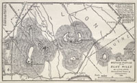
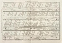
The Blue Hills, E.G. Chamberlain, Appalachian Mountain Club, Appalachia, Vol. 3, pg. 122, 1882 - HathiTrust |
| • |
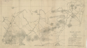
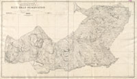
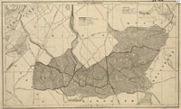
Topographical map of Blue Hills Reservation, Massachusetts. Metropolitan Park Commission, 1895 - Norman B. Leventhal Map Center, Boston Public Library |
| • |
Guide to View from Great Blue Hill, Milton, E.G. Chamberlain, 1904 - Collection of Historical Scientific Instruments, Harvard University |
| • |
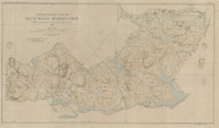
Blue Hills Reservation, Massachusetts. Metropolitan Park Commission, 1905 - Norman B. Leventhal Map Center, Boston Public Library |
| • |
Job #1504, Blue Hills Reservation - Olmstead Archives, NHS, NPS |
| • |
Flora of the Blue Hills Reservation, Metropolitan Park Commission, 1896 - WikiMedia Commons |
| • |
Blue Hills Reservation Trail Map (PDF) - Commonwealth of Massachusetts |
| • |
Historic Writing and Maps - Friends of the Blue Hills |
|
|
| Blue Hills Reservation Sources |
| • |
The Blue Hills, E.G. Chamberlain, Appalachian Mountain Club, Appalachia, Vol. 3, pg. 122, 1882 - HathiTrust |
| • |
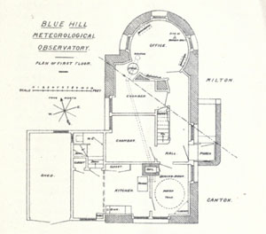
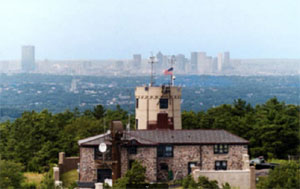
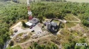
An Account of the Foundation and Work of the Blue Hill Meteorological Observatory, A. Lawrence Rotch, 1887 - HathiTrust |
| • |
A "Massachusetts Forest", Sylvester Baxter, Garden and Forest, Vol. 4, pg. 362, 1891 - HathiTrust |
| • |
Names of the Blue Hillss, E.G. Chamberlain, Boston Transcript, June 4, 1895 - Google News Archives |
| • |
The Blue Hills, Walks and rides in the Country Round about Boston, pg. 333, Edwin M. Bacon, 1897 - Internet Archive |
| • |
The Blue Hills, Sylvester Baxter, Boston Park Guide, pg. 44, 1898 - HathiTrust |
| • |
Pt. 3 Blue Hills Complex, Geology of the Boston Basin, William O. Crosby, 1900 - HathiTrust |
| • |
Charles Eliot, Landscape Architect, Charles W. Eliot, 1902 - Google ebook |
| • |
Blue Hills Reservation -
Department of Conservation & Recreation (DCR), Commonwealth of Massachusetts |
| • |
Friends of the Blue Hills |
| • |
Blue Hills Trailside Museum - Mass Audubon |
| • |
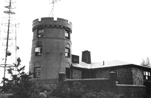
Blue Hills Observatory & Science Center |
| • |
Blue Hills Ski Area |
| • |
Blue Hills Reservation - The Living New Deal |
| • |
Blue Hill Meteorological Observatory - National Park Service |
| • |
The Blue Hill Meteorological Observatory: The First 100 Years, 1885–1985, John H. Conover, 1990 - Google ebook preview |
|
|
| |
|