| Hills of Revere, Mass. |
| | Hills | More about Revere's USGS-listed hills | Maps | Sources | |
| Beachmont Hill |
| • |
Google Maps | Google Earth - Google |
| • |
"...Mr. William Aspinwall...This included all Beachmont. William Aspinwall died about 1662 or later, and his wife's name was Elizabeth. He came over with Winthrop in 1630, was selectman in Boston in 1636-7....", Shurtleff, pg. 33, 1937 - Haithtrust |
| • |
"...Some thirty years after this, on December 16, 1834, John Sale, who owned the present Beachmont .....", Chamberlain, Vol.1 pg. 131 - Internet Archive |
| • |
"...Beachmont was apparently laid out with the general notion that curving streets were bound to fit a steep hill, but the realization of the street system is a melancholy one....", Public Improvements for the Metropolitan District, pg. 239, 1909 - Internet Archive |
| • |
Revere, another time, Beachmont -- a historical overview, "...Any discussion of early Beachmont has to include "The Great Ocean Pier." Approximately from where Elliot Circle is it jutted out into ocean some 1,700 feet .....", Donald Zollo, Sr., 2014 - Facebook |
| • |
William Aspinwal, "...William was also given 164 acres of land in Rumney Marsh encompassing most of what is now the Beachmont section of Revere, Mass....By 1651 William was back in trouble with the Boston Courts and moved with his wife and younger children back to England. There he got caught up in religious fervor after the English Civil War as a supporter of the Fifth Monarchists. It is thought that he died in 1662..." - Winthrop Memorials |
|
| Boutman Hill |
| • |
Google Maps | Google Earth - Google |
| • |
"...The other was known as Boutman Hill, over which Winthrop Avenue formerly ran, and a road running at its foot toward the cemetery, has long since been discontinued. This hill also has been nearly leveled.....", Shurtleff, pg. 12, 1937 - Hathitrust |
|
| Cherry Island Bar |
| • |
USGS identified - MassMapper MassGIS |
| • |
Google Maps | Google Earth - Google |
| • |
"...From this beach near Beachmont, there extended into the sea, a bar of rocks and land known as Cherry Island Bar, so named from a cherry orchard which formerly existed upon it. The soil has long since been washed away by the tides, and only the rocks are left which, in 1881, made a foundation for the great ocean pier...", Shurtleff, pg. 13, 1937 - Hathitrust |
| • |
Cherry Island Bar (Bar) - USGS Geographic Names Information System |
|
| Fennos Hill |
| • |
USGS identified - MassMapper MassGIS |
| • |
Google Maps | Google Earth - Google |
| • |
"...Those in the west were known as Vane Hill, later as Fenno Hill and still later as Mount Revere, with an altitude of one hundred ninety-two feet above mean low tide....", Shurtleff, pg. 12, 1937 - Hathitrust |
| • |
"The Fenno Family - The Fennos who bought the Cheever farm came from Boston, John Fenno and his two sons John and Joseph. Mr. Fenno was a native of Canton .....", Shurtleff, pg. 147, 1937 - HathiTrust |
| • |
"...The Vane allotment has been known for many years as Fenno Hill; but now that it has passed out of the Fenno family, it is worth a thought whether, in honor of a great patriot and friend of the Puritan colonists, it might not well be called Sir Harry Vane Hill .....", Chamberlain, Vol.1 pg. 95, 1908 - Internet Archive |
| • |
Henry Vane the Younger, "...Sir Henry Vane (1613–1662) was an English politician, statesman, and colonial governor. He was briefly present in North America, serving one term as the Governor of the Massachusetts Bay Colony, and supported the creation of Roger Williams' Rhode Island Colony and Harvard College. A proponent of religious tolerance, he returned to England in 1637 following the Antinomian controversy that led to the banning of Anne Hutchinson from Massachusetts...." - Wikipedia |
| • |
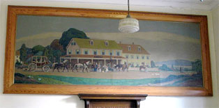
Fenno's Corner Restaurant, "...Erected in 1835, by John Fenno and his son, Joesph, this building has been continuously utilized as a store an inn or restaurant. This inn was a landmark for travellers and served as the 'halfway house' for the stagecoach on the Boston to Lynn run over the Salem Turnpike (now Broadway - Route 107)..." - Massachusetts Historical Commission Information System (MACRIS) |
| • |
Fenno Houise - Massachusetts Historical Commission Information System (MACRIS) |
| • |
The Fenno Family, Allen H. Bent, 1898 - Internet Archive |
| • |
"...This land overlooking the sea and the green marshes and meadows of Rumney Marsh lies upon the southern and eastern slopes of Cheever's Hill, in Revere. It was for many years known as the Fenno farm from its later possessors .....", The History of Malden, Massachusetts, 1633-1785, pg. 272 , Deloraine P. Corey, 1899 - Internet Archive |
| • |
Fennos Hill - USGS Geographic Names Information System |
|
| Janvrin Hill |
| • |
Google Maps | Google Earth - Google |
| • |
"...
There were also two lower elevations, one called in later days Harris or Janvrin Hill, extending from School Street nearly to the Beach, parts of this hill having since been leveled.....", Shurtleff, pg. 12, 1937 - Hathitrust |
| • |
"...
The farm remained in the possession of Samuel Pratt during his life, and then in that of his daughter Martha who married William S. Janvrin. Parts of it to-day are still owned by the Janvrins. The house, in 1912, was turned around so as to face the east, moved a few feet and placed on a new foundation. It originally faced the south.....", Shurtleff, pg. 262, 1937 - Hathitrust |
| • |
"... William Swett Janvrin, a well-known contractor and builder and real estate owner of Revere...The male members of the Janvrin family have been generally noted through several generations for their size and strength, which have been above the average...After his school days were over, he went to Cambridgeport, where he learned the trade of carpenter, completing his apprenticeship at the age of twenty years.", Biographical Sketches of Representative Citizens of the Commonwealth of Massachusetts, pg. 895, 1901 - Hathitrust |
|
| Newgate Hill |
| • |
Google Maps | Google Earth - Google |
| • |
"... Newgate Hill, where now runs Mountain Avenue, with an elevation of one hundred seventy-three fee....", Shurtleff, pg. 12, 1937 - Hathitrust |
| • |
"... Mr. John Newgate, a hundred and twelve acres: This allotment extends from Mountain Avenue to the Shurtleff and Pratt farms, and reaches from Woodlawn nearly to Broadway, and with purchases became the Newgate farm....", Shurtleff, pg. 30, 1937 - Hathitrust |
| • |
"... John Newgate was born in Southwark, England, near London bridge, in 1580, and died in 1665...He was by occupation a felt-maker and became a merchant in Boston in 1632. He was a member of the General Court in 1638....", Shurtleff, pg. 45 , 1937 - Hathitrust |
|
| Point of Pines |
| • |
USGS identified - MassMapper MassGIS |
| • |
Google Maps | Google Earth - Google |
| • |
"...The year 1834 marks the coming to town of one, Solomon Hayes, who purchased the estate known as the Point of Pines, at which time there were no buildings of any sort on the entire beach except here where a tavern was
erected a short time previously. He named the building the Robinson Crusoe House and this tavern became a famed resort...", Shurtleff, pg. 340, 1937 - Hathitrust |
| • |
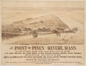
Point of Pines Fire Station, "...Any old-timer will tell you that up to a quarter of a century ago the Point of Pines section of Revere was noted for its clambakes, prizefights, and, as a rendezvous for politicians and excursionists. Its main building was a hotel at which two former presidents, Theodore Roosevelt and William H. Taft stopped to speak during their campaigns...", Works Progress Bulletin, pg. 2, Oct.1937- Internet Archive, The Living New Deal |
| • |
Point of Pines – Massachusetts, "...Point of Pines, situated 5 miles north of Revere Beach’s Wonderland on the north shore of the Bay, was designed by Copeland and Dole, New York architects for the Point of Pines Attraction Company...", Jeffrey Stanton, 2013 - Lost Amusement Parks |
| • |
Point of Pines (Cape) - USGS Geographic Names Information System
Variant name: Pines Point |
|
| Roughans Point |
| • |
Google Maps | Google Earth - Google |
| • |
"...Roughans Point and Cherry Island Bar are the bouldery cobbly erosional remains of a drumlin...", Saugus River and Tributariesm Flood Damage Reduction Study, Vol. 3, pg. E7, 1989 - Google ebook |
| • |
Possibly named for Michael Roughan, "...About 10 years ago [Michael Roughan] bought a large area of land bordering on waterfront at Beachmont, on which he had erected about 50 cottages...", Michael Roughan Dead, Was One of Charlestown's Best Known Citizens - Had Accumulated a Handsome Fortune, Dec. 28, 1912 - Boston Globe |
|
| Shurtleff Hill |
| • |
Google Maps | Google Earth - Google |
| • |
"...Payson Hill, now known as Shurtleff Hill, with its altitude of one hundred feet....", Shurtleff, pg. 12, 1937 - HathiTrust |
| • |
"...Dr. [Benjamin] Shurtleff resided on Tremont Street, Boston opposite the Common but spent much of his time in late life at the farm. In 1837 he built on this
farm the brick house which crowns the brow of the hill and deeded the whole property to his son Benjamin Shurtleff on April 27, 1841....", Shurtleff, pg. 187, 1937 - HathiTrust |
| • |
Benjamin Shurtleff House - Massachusetts Historical Commission Information System (MACRIS) |
| • |
"...[Benjamin Shurtleff] ...His farms at Winnisimmet and North Chelsea were models. He gave a great deal of thought and time to the improvement of the breed of cattle and sheep in this country, and was one of the earliest importers of Ayreshire stock. He had a strong taste for genealogical research and industriously gathered a large amount of information in regard to the ancestry of others as well as his own....", The Descendants of William Shurtleff, pg. 152, Benjamin Shurtleff 6th, 1912 - Internet Archive |
|
| Youngs Hill |
| • |
USGS identified - MassMapper MassGIS |
| • |
Google Maps | Google Earth - Google |
| • |
"...Beach View Hill, later Young's Hill, one hundred thirty-four feet....", Shurtleff, Pg. 12, 1937 - Hathitrust |
| • |
"...The streets upon Young's Hill have been arranged with somewhat greater regard to the contour of the ground, but the street profiles, however, at certain points have prohibitive inclinations.....", Public Improvements for the Metropolitan District, 1909, pg. 239 - Internet Archive |
| • |
"...Mr. [James O.] Young resided for many years in this house on the hill which was named in his honor....", Shurtleff, Pg.307, 1937 - Hathitrust |
| • |
Youngs Hill - USGS Geographic Names Information System |
|
|
|
|
|
| More about Revere's USGS-listed hills |
|
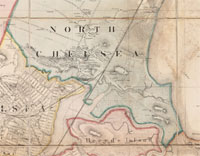
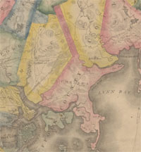
Present-day Revere includes parts of what was known in colonial times as Winnisimmet, Pullen Poynt, and Rumney Marsh. Boston annexed both areas in 1634, and then set them off as the town of Chelsea in 1739. North Chelsea was split off as a town in 1846, with Pullen Poynt splitting off from it to become Winthrop in 1852. In 1871 the name North Chelsea was changed to Revere in honor of the Revolutionary War patriot Paul Revere. It became incorporated as a city in 1915.Like other coastal communities, Revere has hill-like features along that coast, Cherry Island Bar (0 ft. Bar), and Point of Pines (0 ft. Cape). The zero elevation is accurate in the case of Cherry Island Bar. Shurtleff in his history of Revere says the area was named for a cherry orchard that formerly existed there, but the land, a drumlin, was washed away. Point of Pines, at the northern end of Revere Beach, is a sandy promontory at the inlet to Rumney Marsh. It is above sea level. The USGS also lists a Point of Pines Populated Place with an elevation of seven feet. Named reportedly for native pine trees. |
| Like other coastal communities, Revere has hill-like features along that coast. Two USGS-listed in the case of Revere, Cherry Island Bar (0 ft. Bar), and Point of Pines (0 ft. Cape). The zero elevation is accurate in the case of Cherry Island Bar. Shurtleff in his history of Revere says the area was named for a cherry orchard that formerly existed there, but the land, a drumlin, was washed away. Point of Pines, at the northern end of Revere Beach, is a sandy promontory at the inlet to Rumney Marsh. It is above sea level. The USGS also lists a Point of Pines Populated Place with an elevation of seven feet. Named reportedly for native pine trees. |
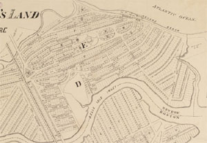
| Revere has two USGS-listed summits, Fennos Hill (180 ft.) and Youngs Hill (121 ft.). Both with family names, and both with families whose ancestors arrived in New England in the 1600s. But in both cases those ancestors did not settle in Revere. John Fenno (c.1629-1708) is recorded in 1660 being granted 20 acres of land in Unquity, then part of Dorchester, now Milton. Many Fenno descendants lived in Milton and Canton. There is a hill in the Blue Hills Reservation that was called Fenno Hill. Coincidently, in the year 1660 George Young (1640-1672) is recorded as settling in Scituate. In the 1800s, descendants of those two men and their families would move to what was soon to become the town of Revere, and live near, or on, the hills that carry their name. |
|
In 1793 John Fenno (1766-1835) moved from Canton to Noddle Island, the future East Boston, to work for Thomas Williams on his farm.2 Just across the harbor from Boston, the then still undeveloped island was a convenient place to graze animals and raise crops that could be sold either in Boston, or to the ships that moored in the harbor. Also in that year John married Olive Pratt (1770-1856). It is recorded as the first marriage to take place in East Boston. Olive was a descendant of Mathew Pratt from Weymouth, not directly related to one of the many Pratts in Chelsea who were descendants of Richard Pratt of Malden. John Fenno’s next step in 1804 was to open a grocery store in Boston located near where the Chelsea ferry landed. In 1829 he bought the Cheever farm in Chelsea. Living now in Chelesa, John’s sons opened a general store and inn at the southern end of the hill. This location was at the corner of the old country road from Lynn to Boston, and the more recently built, 1803, Salem Turnpike. In addition to being the first grocery story in Revere, the inn was a popular half-way stop for travelers between Lynn and Boston. Descendants of John Fenno ran the establishment until the early 1900s. Much modified, the building remained in use until 2007. |
|
According to Shurtleff in his 1937 history of Revere, Youngs Hill near the southern end of Revere Beach was named for James O. Young (1826-1883).3 Unlike the Fenno name which has lived on for multiple generations in Revere, not so that of James Young. Still, Young should be remembered as one of the early visionaries who saw the potential for the Revere beach area. James Young was born in Scituate where his father, Gideon W. Young (1796-1880), was the postmaster. In 1848 his father was nominated to become the postmaster of Chelsea. An 1862 Boston directory shows James Young working as a postal clerk in Chelsea. The year before he had purchased a house on top of a hill located near what was then called Chelsea beach. The area offered beautiful, unspoiled access to the ocean, but it was difficult to get to, and considered far from Boston. But that had begun to change. In 1838 the Eastern Railroad Company finished a line that followed the coast from East Boston all the way to Salem (Note: the completion of this line put a dent in the number of people visiting Fenno’s business on the Salem Turnpike). But the Civil War and then an economic downturn stopped any plans for development from being implemented. By the mid-1870s the economy had improved, and now the whole area north and east of Boston was looking more attractive for a growing population and as a place for recreation. This included East Boston, still at the time basically having the foot print of the original Noddle Island, Breeds Island (today’s Orient Heights), Winthrop, Beachmont, and Revere. Young was one of the developers with big plans. In 1869 he had bought seven more lots on the newly named Beach View Hill. Starting in 1876, Young is involved in multiple development schemes including, having a plan approved for a 1,000-foot iron pier for steamships to dock; being part of group organized to build a three-mile railroad line running from Revere Beach to Everett; serving as trustee in a land sale by the North Shore Land Company; and contracting to build what would be the Pavilion Hotel. There never would be a train line to Everett, and the pier would have to wait for a different developer to be built. Bigger, better-funded developers would offer plans that included local railroad lines and land sales. Young would die at age 57, and his family would leave the area before the turn of the century. Revere beach would become the first public beach in the country, and its amusement parks a popular destination for decades in the 1900s. |
|
|
| Revere Maps |
| • |
Revere - Google Maps, Terrain |
| • |
Revere - MassMapper MassGIS |
| • |
Revere - USGS - The National Map |
| • |
Boston North Quadrangle - 2018 (60 MB PDF) - USGS Topo Download |
| • |
Lynn Quadrangle - 2018 (40 MB PDF) - USGS Topo Download |
| • |
Revere Maps: Plates, P, Q, R, Atlas of Suffolk, County, Vol. 4, G.M. Hopkins & Co., 1874 - State Library of Massachusetts |
| • |
Revere Maps: 12, 13, 14, 15, 16, 17, 18, 19, 20, 21, 22, 23, 24, 25, Atlas of The City of Chelsea and the Towns of Revere & Winthrop, G.W. Bromley & Co., 1914 - State Library of Massachusetts |
| • |
MapJunction |
|
|
| Revere Sources |
| • |
History of the Town of Revere, Benjamin Shurtleff, 1937 - Hathitrust |
| • |
A Documentary History of Chelsea: including the Boston Precincts of Winnisimmet, Rumney Marsh, and Pullen Point, 1624-1824, Vol. 1, Mellen Chamberlain, 1908 - Internet Archive |
| • |
A Documentary History of Chelsea: including the Boston Precincts of Winnisimmet, Rumney Marsh, and Pullen Point, 1624-1824, Vol. 2 , Mellen Chamberlain, 1908 - Internet Archive |
| • |
Revere, Images of America, William J. Craig, 2004 - Internet Archive |
| • |
Public Improvements for the Metropolitan District, Massachusetts. Metropolitan Improvements Commission, 1909 - Internet Archive |
| • |
Revere, MHC Reconnaissance Survey Town Report (PDF), 1981 - Massachusetts Historical Commission |
|
|
| Footnotes |
| 1 |
The Indian Heritage of New Hampshire and Northern New England, pg. 17, Tadeusz Piotrowski, 2002 - Google ebook preview |
|
Historic Boston and its Neighbourhood, pg. 19, Edward E. Hale, 2017- Google ebook preview |
| 2 |
The Fenno Family, Allen H. Bent, 1898 - Internet Archive |
|
The Fenno Family, History of the Town of Revere, pg. 147 , Benjamin Shurtleff, 1937 - Hathitrust |
|
The Salem Turnpike, The Turnpikes of New England, pg. 80, Frederic J. Wood, 1921- Google ebook |
|
The Taverns of Boston in Ye Olden Time, David M. Balfour - Massachusetts Roots |
|
A Piece of History Is Lost; Reardon’s Razed, Seth Daniel, 2015 - Revere Journal |
|
Ancient Revere Building Sold, Historic Fenno Store and Tavern Passes Out of Family's Hands, 1905 - Boston Globe |
| 3 |
George Young, History of Scituate, Massachusett, pg. 393 ,Samuel Deane, 1831 - Google ebook |
|
Vital records of Scituate, Massachusetts, Vol. 1 - Births, pg. 421, 1909 - Internet Archive |
|
Chelsea, Massachusetts, City Directory, pg 86, 1861 - Internet Archive |
|
Suburban Notes, "Revere - James O. Young gas contracted for the erection of a large hotel", Apr. 3, 1876 - Boston Globe |
|
American Railroad Journal, pg. 325, "Revere and Evertt Railroad Company has been organized...James O. Young, Clerk", Vol. 40, 1876 - Google ebook |
|
Public Documents of Massachusetts, pg. 37, "James O. Young, for an iron pier of Revere Beach", Vol. 5, 1877 - Google ebook |
|
The North Shore Land Sale, "A large number of people attended the land sales...James O. Young...trustees of the North Shore Land Company", Sep. 20, 1877 - Boston Globe |
|
Revere Beach, 1896, Charles Eliot: Landscape Architect, pg. 668, Charles W. Eliot, 1903 - HathiTrust |
|
|