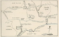
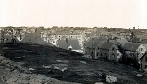
| Hills of Lynn, Mass. |
| | Hills | More about Lynn's USGS-listed hills | Maps | Sources | |
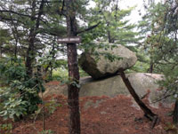
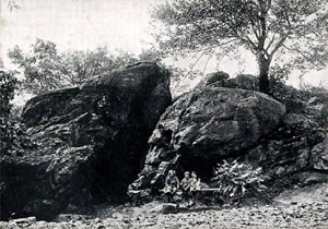
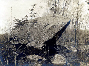
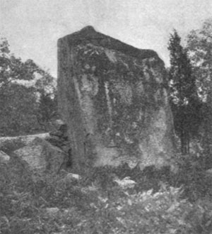
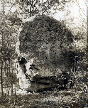
| Balanced Boulder |
|
| Blood Swamp Hill |
|
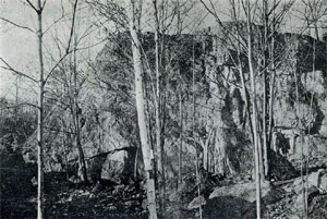
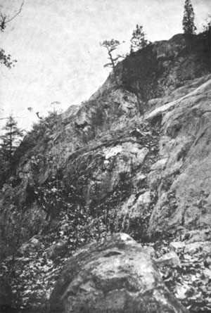
| Bow Ridge |
| • |
USGS identified - MassMapper MassGIS |
| • |
Google Maps | Google Earth - Google |
| • |
Lynn Woods Reservation Trail Map (PDF) - Friends of the Lynn Woods |
| • |
"...Bow Ridge is at the southern extremity of Lynnfield near Nell's Pond, in a retired and rural region, being some way from the road, not far from the Lynn line, and is worth visiting...", Wellman, pg. 6, 1895 - Internet Archive |
| • |
"...In the immediate neighborhood of these quarries exists a curious example of the drift-ridges, so notable in other sections, supposed to be ancient glacial moraines. This, which is called Bow Ridge, is a thick dike of porous gravel, some five hundred feet long, and twenty feet high, on the rear slope, with a flat, pathlike top, not more than ten feet wide. It lies in a semi-oval form, with its convexity toward the north-west, whither the front slopes down thirty or forty feet to an open meadow...", Tracy, pg. 263, 1878 - Internet Archive |
| • |
Bow Ridge (Ridge) - USGS Geographic Names Information System |
|
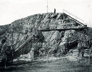
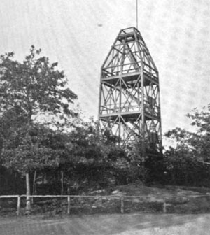
| Burrill Hill |
| • |
USGS identified - MassMapper MassGIS |
| • |
Google Maps | Google Earth - Google |
| • |
Lynn Woods Reservation Trail Map (PDF) - Friends of the Lynn Woods |
| • |
"...Some years ago we restored the name of the fathers to our famed Burrill Hill. Another of our hills, that bold sienite knob on the border line between Saugus and Lynn, has been marked on maps as "Mount Tabor." It is not a mountain. It is a shapely, sightly hill that was known in early deeds and days, as Fuller Hill. ...", Register of the Lynn Historical Society, Vol. 18, pg. 92, 1915 - Internet Archive |
| • |
Stone Tower: "...Stone Tower is a 48 ft. tall field stone tower on the top of Burrill Hill...Built for fire observation, the tower had a wooden roof structure constructed on its top to provide shelter for crews that would man it...." - Friends of Lynn Woods |
| • |
"...George Burrill lived on the western side of Tower Hill. He was a farmer, and had 200 acres of land...Burrill was one of the richest oi the planters...The Burrill family was formerly called the royal family of Lynn, in. view of the many famous persons connected with it...", Lewis, Newhall, pg. 115 , 1865 - Internet Archive |
| • |
"...Ebenezer Burrill (1679-1761)...He was a man remarkable for sound judgment, benevolence, and activity in all useful enterprises, was six times chosen Representative, and was a Counsellor in 1731 and 1746. In 1732 be was entrusted with the settlement of important business with the Indians at Casco Bay. He possessed a large estate in lands, and was able to provide well for his numerous family...", Lewis, Newhall, pg. 492 , 1865 - Internet Archive |
| • |
"...Burrill Hill...Its charms have been sung in graceful verse by our prophet of the woods, and consecrated by the Society of the Forest, under the name of Mount Nebo. ...", Hawkes, pg. 47, 1893 - Internet Archive |
| • |
Lynn Woods Reservation: Stone Tower – Lynn MA, "...Burrill Hill is elevated at 285 feet above sea level and Stone Tower sits on top of the hill at 48 feet tall and approximately 30 feet in diameter..." - The Living New Deal |
| • |
Atlas of the City of Lynn, Mass., Plate 18, L.J. Richards & Co., 1897 - State Library of Massachusetts |
| • |
Likely reference to Biblical Mount Nebo (Wikipedia) |
| • |
Burrill Hill - USGS Geographic Names Information System
Variant name: Mount Nebo |
|
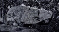
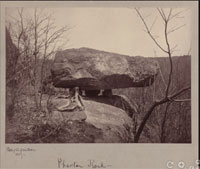
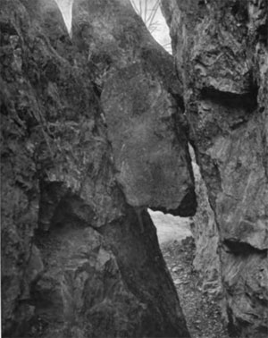
| Cannon Rock |
| • |
Google Maps | Google Earth - Google |
| • |
"...Cannon Rock was mistaken for a cannon during the Revolutionary War. It is perched on three small stones on the edge of a cliff. In the 19th century it was considered evidence of Viking settlement in the area...
...The rock is also known as Phaeton Rock or The Lynn Dolmen, and weighs an estimated 65 tons....", Lynn, Massachusetts: Cannon Rock, Vikings and Druids, - RoadsideAmerica.com |
| • |
"...Probably the most researched boulder in Lynn through the years has been Phaeton Rock which is a stunning dolmen on a ledge...", Lynn Boulders & Dolmens Pt. 1 - Phaeton Rock, - Stone Ruins Of the North Atlantic, Emphasizing the New England Region |
|
| Cedar Hill |
|
| Christian Hill |
|
| Dog Hill |
|
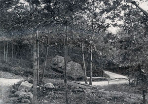
| Dungeon Rock |
| • |
USGS identified - MassMapper MassGIS |
| • |
Google Maps | Google Earth - Google |
| • |
Lynn Woods Reservation Trail Map (PDF) - Friends of the Lynn Woods |
| • |
"...The Pirate's Glen and Dungeon Rock have for generations attracted the steps of those who are lured by the myste
rious or wild. Around the latter, especially, have been woven dark legends of tragic deeds and buried treasure....
The Dungeon Rock has been for more than twenty years the scene of persevering labor with drills and gunpowder, supervised by supposed spiritual adepts, in the hope of reaching, somewhere in the bowels of the obdurate greenstone ledge, gold and jewels, deposited there by piratical hands, the pirate himself having been inhumed
with his treasures by an earthquake, in 1658 ...", Newhall, pg. 77, 1876 - Internet Archive |
| • |
Stay Tuned: Dungeon Rock, "...Thomas Veal...He lived there until the great earthquake loosened the top of the rocks that crushed down into the mouth of the cavern, entombing him in his prison. This is known as Pirate's Dungeon...", Jeanne Curley, 2002 - Friends of Lynn Woods |
| • |
Dungeon Rock - USGS Geographic Names Information System |
|
| Echo Rock |
| • |
Google Maps | Google Earth - Google |
| • |
"...The best point of observation for those who visit the woods by carriage is from Echo Rock, from whence it may be seen northwesterly over Glen Lewis Pond ...", Hawkes, pg. 78, 1893 - Internet Archive |
| • |
Topographic Map of Lynn Woods, John N. McCintock, 1892, Lynn Park Commissioners, Olmsted Archives, - NHS/NPS |
|
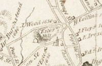
| Estes Hill |
| • |
Google Maps | Google Earth - Google |
| • |
Map of Lynn and Saugus, Alonzo Lewis, 1829 - Norman B. Leventhal Map Center, Boston Public Library |
| • |
Estes Genealogies, 1097-1893, Charles Estes, 1894 - Internet Archive |
| • |
"...Richard Estes (1647-1737) was a prominent Friend in Salem who was a major representative of the community in its fight for toleration in the late seventeeth and early eighteenth centuries...", Analecta Hibernica, No. 39, pg. 170, Kevin Herlihy, 2006 - JSTOR |
|
| Farringtons Hill |
| • |
Google Maps | Google Earth - Google |
| • |
"...In the snow storm on the 6th of February, a woman perished on Farrington's Hill, on the Turnpike, one mile eastward of the Lynn Hotel.....", Lewis, Newhall, pg. 394, 1865 - Internet Archive |
| • |
"...Edmund Farrington embarked in the Hopewell, of London, 1 April, 1635, with his wife and four children...He was a farmer, and had 200 acres of land, part of which was on the western side of Federal street, where he lived, and part on the western side of Myrtle
street....", Lewis, Newhall, pg.153, 1890 - Internet Archive |
| • |
Map of Lynn and Saugus, Alonzo Lewis, 1829- Norman B. Leventhal Map Center, Boston Public Library |
|
| Forest Castle |
|
| Fox Rock |
|
| Fuller Hill |
|
| Great Frog Boulder |
| • |
Google Maps | Google Earth - Google |
| • |
...The same committee, intent upon its exploring and descriptive work half a century ago in the following words speak of
the boulder which is now known as "The GreatFrog."...Crossing the head of Blood's Swamp we enter a territory called the "Ox Pasture," and passing up towards the west it was noticed that boulders increased in numbers and size to such
an extent that to measure and describe those of the size noticed in many other localities would be impossible...", Lynn Park Commissioners, pg. 197, 1905 - HathiTrust |
| • |
Lynn Woods Reservation Trail Map (PDF) - Friends of the Lynn Woods |
|
| Half Way Rock |
|
| Hemlock Ridge |
|
| High Rock |
| • |
USGS location - MassMapper MassGIS |
| • |
Google Maps | Google Earth - Google |
| • |
"...High Rock is a remarkable crag, rising to a height of one hundred and eighty feet in the heart of the city, the abrupt
terminus of a spur of the hills that form Lynn's inland wall. At its foot lies the busiest part of the busy city, and close under it nestles the Hutchinson cottage, home of the famous family of singers, whose name a few years ago was a house hold word. From the summit of the rock, reached by an iron-framed stairway, a comprehensive view of Lynn, with its beautiful surroundings of hill and sea and shore
...", Start, pg. 520, 1891 - Internet Archive |
| • |
"...Their favorite places of residence hereabout; appear to have been in the neighborhood of Sagamore Hill and High Rock, at Swampscot and Nahant...", Lewis, Newhall, pg. 44, 1865 - Internet Archive |
| • |
High Rock - USGS Geographic Names Information System |
|
| Hoarhound Hill |
|
| Indian Hill |
|
| Lantern Rock |
|
| Long Hill |
|
| Lovers Leap |
| • |
Google Maps | Google Earth - Google |
| • |
Google Maps location, 3D view (PC) - Google Maps |
| • |
"...From thence the fields extended to the northern edge of hills, and Lover's Leap, which was at that time call Witt's Rock
...", Register of the Lynn Historical Society, Vol. 19, pg. 39, 1915 - Google ebook |
| • |
Map of Lynn and Saugus, Alonzo Lewis, 1829- Norman B. Leventhal Map Center, Boston Public Library |
|
| Mansfield Hill |
| • |
Google Maps | Google Earth - Google |
| • |
Atlas of Essex County, Geo. H. Walker & Co., 1884 - Ward Maps |
| • |
"...Andrew Mansfield came from Exeter, in England, to Boston, in 1636. He came to Lynn, in 1640. He was a farmer, and lived in Boston street. The neighborhood in which he lived was called Mansfield's End. He was town clerk in 1660, and died in 1692, aged 94...", Lewis, Newhall, pg. 187, 1865 - Internet Archive |
|
| Mount Gilead |
|
| Mount Hermon |
|
| Mount Lebanon |
|
| Mount Moriah |
|
| Mount Seir |
|
| Mount Spickett |
|
| Mowers Hill |
| • |
"...no school house was erected by the town until 1728, when two were built; one in Laighton's lane -- now Franklin street -- the other on a lot of land some distance west of 'Mower's Hill.' This was a hill lying between Tower Hill and East Saugus, on the old Boston road.....", Johnson, pg. 376, 1880 - Internet Archive |
|
| Overlook Craig |
|
| Pine Hill |
| • |
USGS identified - MassMapper MassGIS |
| • |
Google Maps | Google Earth - Google |
| • |
"...Pine Hill is half a mile west from Lover's Leap. It is two hundred and twenty-four feet in height. The southwestern extremity of this hill is called Sadler's Rock, which is one hundred and sixty-six feet high....", Lewis, Newhall, pg. 69, 1890 - Internet Archive |
| • |
"...The territory known as Pine Hill, bounded by Forest street, on the east, and Walnut street, on the south, contained no dwelling until 1850, when Nathaniel Holder built the first house on that eminence....", Johnson, pg.316, 1880 - Internet Archive |
| • |
Pine Hill - USGS Geographic Names Information System |
|
| Prospect Hill |
|
| Red Rock |
| • |
USGS identified - MassMapper MassGIS |
| • |
Google Maps | Google Earth - Google |
| • |
...Porphyry commences at Red Rock, and passing through the town in a curve toward the northwest, forms a range of hills, including High Rock, Lover's
Leap, and Sadler's Rock...", Lewis, Newhall,, pg. 72, 1895 - Internet Archive |
| • |
...There is now a difficult path around Red Rock which only the most agile climbers attempt...", Lynn Park Commissioners, pg. 11, 1892 - Library of Concress |
| • |
Red Rock (Cape) - USGS Geographic Names Information System |
|
| Sadlers Rock |
| • |
Google Maps | Google Earth - Google |
| • |
Google Maps location, 3D view (PC) - Google Maps |
| • |
"...Pine Hill is half a mile West from Lover's Leap. It is two hundred and twenty-four feet in height. The southwestern extremity of this hill is called Sadler's Rock, which is one hundred and sixty-six feet high...Richard Sadler, farmer, freeman 1638, came from Worcester, in England. He lived near the great rock in Holyoke street. He was a member of the Salem Court in 1639, and clerk of the writs in 1640...", Lewiis, pg. 93, 1916 - Internet Archive |
|
| Sagamore Hill |
| • |
Google Maps | Google Earth - Google |
| • |
"..Sagamore Hill is a very pleasant eminence at the northern end of Long Beach, sixty-six feet in height. It slopes to the harbor on one side, and to the ocean on the other, and has the town tying beautifully in the back ground....", Lewis, Newhall, pg. 69, 1865 - Internet Archive |
| • |
"..On the third of April 1646, he sold to Daniel King, 'one parcel of land, called Windmill Hill,' being the eastern
mound of Sagamore Hill. ...", Lewis, Newhall, pg. 127, 1865 - Internet Archive |
| • |
"...Montowampate (Sagamore James), whose wigwam was on Sagamore Hill, tradition says near the crossing of Newhall and Sagamore Streets
...", Register of the Lynn Historical Society, Vol. 17, pg. 53, 1915 - Google ebook |
| • |
Montowampate: "...Montowampate resided on Sagamore Hill in Lynn, a high bluff located near the head of Long Beach...." - Wikipedia |
| • |
"..Mr. Humfrey built a windmill on the eastern mound of Sagamore Hill, which was thence called Windmill Hill...", Lewis, Newhall, pg. 165, 1865 - Internet Archive |
| • |
"..On the third of April 1646, he sold to Daniel King, 'one parcel of land, called Windmill Hill,' being the eastern
mound of Sagamore Hill. ...", Lewis, Newhall, pg 127, 1865 - Internet Archive |
|
| Sugar Loaf Rock |
|
| Sunadin Rock |
| • |
"...In the northern part of the town is Sunadin Rock, which furnishes a view of Monadnoc and Wachusett, with the chain of the Green Mountams for nearly two hundred miles...", Lewis, pg. 244, 1829 - Internet Archive |
| • |
Map of Lynn and Saugus, Alonzo Lewis, 1829- Norman B. Leventhal Map Center, Boston Public Library |
| • |
City of Lynn, Mass., D.G. Beers & Co., 1872 - Salem State University |
|
| Tower Hill |
| • |
Google Maps | Google Earth - Google |
| • |
"...George Burrill may be named as the American head of a most worthy family. He came to Lynn in 1630, and settled at Tower Hill. His descendants have left imprints upon our nation's history which will not be effaced
...", Newhall, pg. 18, 1876 - Internet Archive |
| • |
"..A farm of about fifty acres was purchased by the town, and a new poor-house built on Willis's hill. [I do not understand why Mr. Lewis, here and in one or two other places, calls this Willis's hill. No one else appears to have done so. True, one of the early settlers, named Willis, owned lands hereabout, but
the hill does not appear to have been called by his name....", Lewis, Newhall, pg.381, 1865 - Internet Archive |
| • |
Map of Lynn and Saugus, Alonzo Lewis, 1829- Norman B. Leventhal Map Center, Boston Public Library |
|
| Union Rock |
|
| Water Hill |
| • |
Google Maps | Google Earth - Google |
| • |
"...Edmund Farrington embarked in the Hopewell, of London, 1 April, 1635, with his wife and four children. ... In 1655 he built a corn mill on Water Hill, where a pond was dug, and a water course opened for half a mile...", Lewis, Newhall, pg. 153, 1865 - Internet Archive |
| • |
"...Mr. Bowler, who had a bake-house and a little shop on Water Hill, had a quantity of tea in store, a company of women went to his house, demanded the tea, and destroyed it.
...", Newhall, pg. 54, 1876 - Internet Archive |
| • |
"...He was born at Lynn, on that part of Water Hill now called Marion street, on the 27th of June, 1750.
...", Newhall, pg. 497, 1876 - Internet Archive |
| • |
"...Voted, That one of the school houses shall be removed to 'Mill Hill (Water Hill.) ....", Johnsonl, 1880, pg. 366, - Internet Archive |
|
| Weetamoo Cliff |
|
| Whales Back |
| • |
...A short distance from the west side of Woodlawn street, near its junction with Lovers' Leap avenue, is a rock projecting through the drift, called the Whale's Back. It bears a strong resemblance to a cetecean with its head and flukes under water. From its rounded outline it has commonly been supposed to be a partially buried boulder, but a close inspection might prove otherwise...", Lynn Park Commissioners, pg.27, 1900 - HathiTrust |
|
| Wolf Hill |
| • |
Google Maps | Google Earth - Google |
| • |
"..The first meeting-house of the Society of Friends, says an old record of one of their members, 'was raised on Wolf Hill. This site was on Broad street, nearly opposite Nahant...", Lewis, Newhall, pg. 165, 1865 - Internet Archive |
| • |
"...On April 17, 1722, Richard Estes gave to the "people of God, called Quakers " ninety poles of land upon which to erect a meetincr-house and for a burying ground...As the meeting-house stood upon a hill, called 'Wolf hill', the street naturally bent to the south to turn into Nahant street. This hill at the northerly end of Nahant street was the
first one to be called 'Pudding hill'...", Register of the Lynn Historical Society, Vol. 10, pg. 63, 1906 - Internet Archive |
| • |
".....runs eastward by the old site of the Quaker meeting-house on 'Wolf Hill,' afterward 'Pudding Hill,' and now Washington Square...", Tracy, pg. 256, 1878 - Internet Archive |
| • |
Map of Lynn and Saugus, Alonzo Lewis, 1829- Norman B. Leventhal Map Center, Boston Public Library |
|
|
|
 |
|
 |
|
 |
|
 |
|
 |
|
 |
|
 |
|
| Balanced Boulder |
 |
|
| Cannon Rock |
 |
|
 |
|
| Cedar Hill |
 |
|
| Dungeon Rock |
 |
|
 |
|
| Estes Hill |
 |
|
| Echo Rock |
 |
|
| Forest Castle |
 |
|
| Fuller Hill |
 |
|
| Great Frog Rock |
 |
|
| High Rock |
 |
|
 |
|
 |
|
| Hoarhound Hill |
 |
|
| Lantern Rock |
 |
|
| Mount Gilead |
 |
|
 |
|
| Overlook Crag |
 |
|
| Union Rock |
 |
|
| Weetamoo Cliff |
 |
|
| |
|
|
| More about Lynn's USGS-listed hills |
|
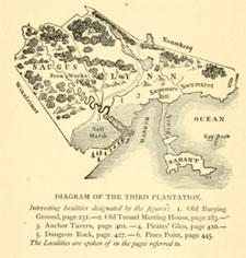
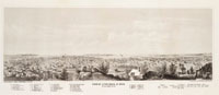
The histories written about Lynn identify two brothers, Edmund and Francis Ingalls, as the first Europeans to settle in the area in 1629. Edmund was a farmer and brewer, Francis was a tanner, likely the first of that profession in New England.1 The area they settled was known as Saugus. That was the word used by the Native Americans they met to describe the outlet into the Atlantic Ocean of the Abousett River (today’s Saugus River).2 Because neither brother ever became a freeman, it is thought that two likely had left Salem to escape the restrictions of the Puritan community. Lynn, like the early towns of Boston, Salem, and Charlestown, has no official act of incorporation. Some put the date at 1630, when the admission one or more freeman from Saugus to the General Court verified the settlement.3 In 1631, public records mention the “plantation of Saugus” in a tax act.4 In New England, the term plantation can describe a sort of pre-town. James R. Newhall5 titled his 1862 book, "Lin: or Jewels of the Third Plantation", with Plymouth the site of the first plantation, Wollaston and Quincy the second, and Lynn the third.6 In 1637, a record in the General Court states, “Saugust is called Lin”,7 this to honor the recent arrival of Rev. Samuel Whiting. Who came from King’s Lynn in England.8 |
|
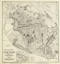
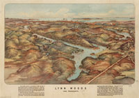
Lynn has 13 USGS-listed hills. Of those, seven are within the boundaries of the Lynn Woods Reservation.9 Initially called Lynn Commons, the area was shared by the inhabitants of Lynn and used primarily as a source of fire wood. Population growth in the mid-1800’s, and a bad fire in 1868,10 led town officials to purchase ponds in Lynn Commons as a source for water. The effort was lead by Edwin Walden,11 first president of the Lynn Public Water Board, and the person who the Walden Pond in Lynn was named. The construction and road building in the forest concerned Cyrus M. Tracy12 and his “Exploring Circle”, a group who devoted to investigating and describing the woods. In 1881 he formed the Trustees of the Free Public Forest to solicit donations of money and land to preserve the woods. Progress was slow until 1887 when prominent and wealthy citizen, Philip A. Chase,13 became involved. His efforts rallied support and lead to the creation by the City of the Board of Park Commissioner, with Chase as the first president. Pooling resources of the City of Water Board started progress resulting in today’s 2,200-acre park. No hills are named after Tracy or Chase. |
|
|
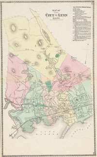
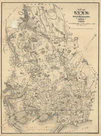
| Lynn Maps |
| • |
Lynn - Google Maps, Terrain |
| • |
Lynn - MassMapper: MassGIS |
| • |
Lynn - USGS - The National Map |
| • |
Boston North Quadrangle - 2018 (60 MB PDF) - USGS Topo Download |
| • |
Lynn Quadrangle - 2018 (40 MB PDF) - USGS Topo Download |
| • |
Reading Quadrangle - 2018 (60 MB PDF) - USGS Topo Download |
| • |
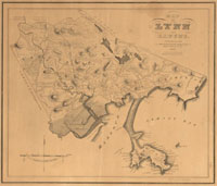
Map of Lynn and Saugus, Alonzo Lewis, 1829- Norman B. Leventhal Map Center, Boston Public Library |
| • |
Atlas of Lynn, Massachusetts, G. M. Hopkins, 1880 - State Library of Massachusetts |
| • |
Atlas of Lynn, Massachusetts, L. J. Richards, 1897 - State Library of Massachusetts |
| • |
Lynn Historical City Maps - City of Lynn |
| • |
City of Lynn, Sampson, Murdock & Co., 1898 - Olmstead Archives, NHS, NPS |
| • |
Lynn Woods Reservation Trail Map (PDF) - Friends of the Lynn Woods |
| • |
Lynn Woods, Handy Guide for Trampers, Lynn Park Commission, 1905 - Norman B. Leventhal Map Center, Boston Public Library |
| • |
Atlas of Essex County, Geo. H. Walker & Co., 1884 - Ward Maps |
| • |
Lynn Woods, Lynn, Massachusetts, Geo. H. Walker & Co., 1904 - Norman B. Leventhal Map Center, Boston Public Library |
|
|
| Lynn Sources |
| • |
History of Lynn, Alonzo Lewis, 1829 - Internet Archive |
| • |
History of Lynn, including Nahant, Alonzo Lewis, 1844 - Internet Archive |
| • |
Lin: or Jewels of the Third Plantation, James R. Newhall, 1862 - Internet Archive |
| • |
Lin: or Jewels of the Third Plantation, Second edition, James R. Newhall, 1880 - Internet Archive |
| • |
History of Lynn, Essex County, Massachusetts, including Lynnfield, Saugus, Swampscott, and Nahant, Alonzo Lewis, James R. Newhall, 1865 - Internet Archive |
| • |
History of Lynn, Essex County, Massachusetts, including Lynnfield, Saugus, Swampscott, and Nahant (PDF), Alonzo Lewis, James R. Newhall, 1865 - Library of Congress |
| • |
Centennial Memorial of Lynn, Essex County, Massachusetts, James R. Newhall, 1876 - Internet Archive |
| • |
The City of Lynn, New England Magazine, pg. 497. Edwin A. Start, 1891 - Internet Archive |
| • |
History of Lynn, Essex County, Massachusetts, including Lynnfield, Saugus, Swampscott, and Nahant (PDF), Alonzo Lewis, James R. Newhall, 1865 - Library of Congress |
| • |
History of Lynn, Essex County, Massachusetts, including Lynnfield, Saugus, Swampscott, and Nahant, 1629-1864, Alonzo Lewis, James R. Newhall, 1890 - Internet Archive |
| • |
History of Lynn, Essex County, Massachusetts, including Lynnfield, Saugus, Swampscott, and Nahant, 1864-1890, James R. Newhall, 1890 - Internet Archive |
| • |
Lynn, Standard History of Essex County, Massachusetts, Embracing a History of the County from its First Settlement to the Present Time, Cyrus M. Tracy, 1878 - Internet Archive |
| • |
Lynn, Poetry of Places in Essex County - North Shore Community College |
| • |
Sketches of Lynn or the Changes of Fifty Years, David N. Johnson, 1880 - Internet Archive |
| • |
Annual report of the Park Commissioners of the City Lynn, Vol. 1-11 (1889-1899), Vol. 12-18 (1900-1906) - HathiTrust |
| • |
The Great Woods and other Public Reservations of Lynn, Park Commisioners of Lynn, 1900 - Google ebook |
| • |
In Lynn Woods, with Pen and Camera, Nathan M. Hawkes, 1893 - Internet Archive |
| • |
The Register of the Lynn historical Society, Lynn, Massachusetts - Internet Archive, HathiTrust |
| • |
Lynn, Mass: Postcard History Series, Diane Shepard, 1998 - Google ebook preview |
| • |
Lynn Woods Historic District - National Park Service |
| • |
Lynn Woods Reservation - Massachusetts Historical Commission Information System (MACRIS) |
| • |
"So Near the Metropolis" - Lynn Woods, a Sylvan Gem in an Urban Setting (PDF), Arnioldia, Elizabeth H. Cushing, 1998 - The Arnold Arboretum of Harvard University |
| • |
Geology of the Igneous Rocks of Essex County, Massachusetts, Charles H. Clapp, USGS, Dept. of the Interior, 1921 - Google ebook |
|
|
| Footnotes |
| 1 |
The Ingalls family in England and America, pg. 11 , Walter R. Ingalls, 1930 - Internet Archive |
| 2 |
Dictionary of American-Indian place and Proper Names in New England, Robert A. Douglas-Lithgow, 1909 - Internet Archive |
| 3 |
Lewis, pg. 82, 1884 - Google ebook |
| 4 |
Start, pg. 500, 1891 - Internet Archive |
| 5 |
James R. Newhall (1809-1893) Papers - Phillips Library Digital Collextions, Peabody Essex Museum |
| 6 |
Alonzo Lewis, James R. Newhall, pg. 56, 1865 - Internet Archive |
| 7 |
Report of the Custody and Condition of Public Records, pg. 300, 1889 - Google ebook |
| 8 |
Newhall, pg. 13, 1876 - Internet Archive |
| 9 |
"So Near the Metropolis"- Lynn Woods, a Sylvan Gem in an Urban Setting (PDF), Elizabeth H. Chushng, Arnoldia, 1988 - Arnold Arboretum |
| 10 |
The Great Fires of Lynn, Images of America, Bill Conway, Diane Shephard, 2006 - Google ebook preview |
| 11 |
Hawkes, pg. 13, 1893 - Internet Archive |
| 12 |
Cyrus M. Tracy, Lynn Park Commissioners Report, pg. 116, 1891 - HathiTrust |
| 12 |
Phlilip August Chase, Register Lynn Historical Society, pg. 54 , 1903 - Internet Archive |
|
Phlilip August Chase, City of Lynn Annual Report, pg. 145, 1903 - Google ebook |
|
|