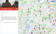
| Hills of Lexington, Mass. |
| | Hills | More about Lexington' USGS-listed hills | Maps | Sources | |
| Belfry Hill |
| • |
USGS identified - MassMapper MassGIS |
| • |
Google Maps | Google Earth - Google |
| • |
"...In the centre of the town, within five or six rods of the Common from which it is separated by the street, rises 'Belfry Hill', so called, from the fact that a structure was formerly erected on this hill, in which the church bell was hung..." - Hudson, pg. 468, 1868 - Internet Archive |
| • |
"...In 1796 the belfry was removed to the Parker homestead in the south part of the town, and nearh a century thereafter, in 1891, it was donated to the Lexington Historical Society, and by that society placed on its present site, now known as 'Belfry Hill' ..." The Story of the "Old Belfry", pg. 23 - Views and description history of Lexington and Concord, Massachusetts, Ormby G. Seeley, ilbert, 1901 - Internet Archive |
| • |
Belfry Hill - USGS Geographic Names Information System |
|
| Bucks Hill |
| • |
USGS identified - MassMapper MassGIS |
| • |
Google Maps | Google Earth - Google |
| • |
"David Fiske...He was a weaver, and, to distinguish him from others of the same name, he was called 'Weaver David.' He was famous as a hunter. Though the wild game was not very plenty in his day, he contributed greatly to thin off the deer, bears, &c.; He ran down and killed a stately buck on the hill over which the Burlington road ran, and hence it has taken the name of 'Buck's Hill.'......" - Hudson, pg. 72, 1868 - Internet Archive |
| • |
Bucks Hill - USGS Geographic Names Information System |
|
| Fullers Hill |
|
| Granny Hill |
| • |
USGS identified - MassMapper MassGIS |
| • |
Google Maps | Google Earth - Google |
| • |
"...This hill had acquired the insignificant name of "Granny Hill," but the inhabitants in town meeting assembled, in November, 1867, gave it the more worthy name of "Hancock Height," in honor of their first permanent minister, and his grandson, Hon. John Hancock, of Revolutionary memory, whose association with and regard for the town are well known and recognized.....
...Regardless of the vote of the town, the name in common use to-day is Granny Hill, while "Hancock Height " is seldom heard. Granny Hill is used by the United States Geological Survey. The name originated from "Granny" Harrington (Abigail), widow of Henry Harrington, who lived on the easterly side of the hill now known as Grant Street. " - Hudson, pg. 469, 1868 - Internet Archive |
| • |
"...New areas on the slopes of Granny Hill (or Hancock Heights), on the plain bounded by Massachusetts Avenue, Lincoln Street, and Waltham Street. " - Hudson, pg. 302, 1868 - Internet Archive |
| • |
"...Hancock Height. About one hundred and twenty rods northeasterly of Meriam's Hill, and forming a part of the
same swell of land, rises abruptly one of the most conspicuous elevations in the town...." - Hudson, pg. 468, 1868 - Internet Archive |
| • |
Granny Hill - USGS Geographic Names Information System
Variant name: Hancock Heights |
|
| Juniper Hill |
| • |
Google Maps | Google Earth - Google |
| • |
Juniper Hill, "...Juniper Hill offers lovely wooded paths that lead through a red maple swamp, upland oak woods, a grassy knoll, and a shaded cedar hill..." (PDF), Lexington Conservation Lands - Town of Lexington |
|
| Lexington Heights |
| • |
Google Maps | Google Earth - Google |
| • |
Liberty Heights,"...Sited on the top of a substantial hill in East Lexington, south of Massachusetts Avenue, Liberty Heights is an early 20th century residential neighborhood which was divided into 30' x 80' lots by Brookline developer Jacob W. Wilbur in 1909..", Area Summaries - Lexington Historical Commission |
|
| Liberty Heights |
| • |
Google Maps | Google Earth - Google |
| • |
Lexington Heights/Meagherville,"...Located in the northwest part of town, Lexington Heights, or Meagherville as it became known, was a residential subdivision that was developed by Chicago resident Mark C. Meagher in 1891. What had been the 260-acre Elm Hill Farm, owned by the Reed family since the early 18th century, was laid out by Meager into 2,814 tiny lots - most measuring 25' x 100'...", Area Summaries - Lexington Historical Commission |
|
| Loring Hill |
| • |
USGS identified - MassMapper MassGIS |
| • |
Google Maps | Google Earth - Google |
| • |
"..Loring's Hill, about half a mile southerly from the centre of the town, rises somewhat abruptly from the
meadows which skirt Vine Brook, to the height of about one hundred and fifty feet...", Hudson, pg. 470, 1868 - Internet Archive |
| • |
"...Joseph Loring (Joseph, John, Thomas), born at Hingham September 28, 1684...He removed to that part of Cambridge called The Farms, which was afterward incorporated as Lexington. Was a housewright by trade; elected at various times to town offices, assessor, constable, treasurer; also one of the deacons of the church..." - Loring Genealogy, pg. 43, Charles H. Pope, Ketherine P. Loring, 1917 - Internet Archive |
| • |
"...Joseph Loring (Joseph, Joseph, John, Thomas), born at Lexington August 21, 1713...He resided at Lexington...He was a deacon of the church of Lexington and a selectman. At the battle, April 19, 1775, his house was one of those wantonly burned by the British....." - Loring Genealogy, pg. 75, Charles H. Pope, Ketherine P. Loring, 1917 - Internet Archive |
| • |
Loring Hill - USGS Geographic Names Information System
Variant names: Fair Oaks Hill, Scott Hill |
|
| Masons Hill |
| • |
"...But the East Lexington School at Mason's Hill, across the street from Munroe Tavern...", Kollen, pg. 43, 2004 - Google ebook preview |
| • |
"...John Mason...He lived on Main street, a little below the old Munroe Tavern, and hence the name of 'Mason's Hollow'...." - Hudson, pg. 131, 1868 - Internet Archive |
|
| Merriam Hill |
| • |
USGS identified - MassMapper MassGIS |
| • |
Google Maps | Google Earth - Google |
| • |
Merriam Hill, "...The area takes its name from the pre-Revolutionary Meriam family who owned much of area in the 19th century...", Area Summaries - Lexington Historical Commission |
| • |
"...Merriam's Hill, situated about eighty rods northeasterly of the village, is elevated seventy or eighty feet above Main street, and affords a good view of the central part of the town...." - Hudson, pg. 416, 1868 - Internet Archive |
| • |
The Merriam Family, "...The Merriams were very numerous in Lexington during the first seventy-five years of her history...." - Hudson, pg. 136, 1868 - Internet Archive |
| • |
Merriam Hill - USGS Geographic Names Information System |
|
| Mount Ephraim |
| • |
USGS identified - MassMapper MassGIS |
| • |
Google Maps | Google Earth - Google |
| • |
"...Edward Winship was one of the original owners of land within the present limits of Lexington, though
he probably never lived within the township. He owned a large tract bordering upon the Arlington line... including the lands now occupied by one of his descendants, and also Mount Ephraim, which took its name from his eldest son, Ephraim, who resided near it....." - Hudson, pg. 24, 1868 - Internet Archive |
| • |
Mount Ephraim - USGS Geographic Names Information System |
|
| Mount Independence |
| • |
USGS identified - MassMapper MassGIS |
| • |
Google Maps | Google Earth - Google |
| • |
"...Mount Independence, near the East Village, rises abruptly about one hundred and thirty feet above the main
street. It is nearly opposite the church, and commands a full view of the village, and the high lands on the opposite side of the broad meadows which spread out on each side of Mill Brook. On the 4th of July, 1824, a
piece of ordnance was presented by a citizen of the village, for the use of the inhabitants; and the name of 'Mount Independence' was given to this hill, under the folds of the Stars and Stripes, and amid the roar of cannon and the huzzas of the citizens....." - Hudson, pg. 471, 1868 - Internet Archive |
| • |
Follen Hill, "...Residential neighborhood adjacent to town center... Also known as Mount Independence..." (PDF), Lexington Reconnaisance Report, Freedom's Way Landscape Inventory - State of Massachusetts |
| • |
Charles Follen, "...Charles Follen was a German poet and patriot, who later moved to the United States and became the first professor of German at Harvard University, a Unitarian minister, and a radical abolitionist...He had designed its unique octagonal building, for which ground was broken on July 4, 1839. Follen's octagonal building is still standing, and is the oldest church structure in Lexington..." - Wikipedia |
| • |
Mount Independence - USGS Geographic Names Information System |
|
| Munroe Hill |
| • |
USGS identified - MassMapper MassGIS |
| • |
Google Maps | Google Earth - Google |
| • |
Munroe Hill, "...Formed in 1891, the Lexington Land Company was responsible for the development of Munroe Hill. Among its trustees were William H. Mason, a real estate broker with offices in Boston, and James S. Munroe, who was born at the old Munroe Tavern in 1824 and resided for his entire life in the immediate neighborhood of his birthplace...", Area Summaries - Lexington Historical Commission |
| • |
"...is highly probable that the Munroes who settled in New England were prisoners of war taken by Cromwell, and sold as slaves or apprentices, as the term was.... The Munroes were probably some of those who were taken at the battle of
Worcester, where Cromwell was victorious. In 1651, a cargo of prisoners was consigned to Thomas Kemble of Boston. The list of prisoners contains the names of four Munroros, as the name was there
spelled, viz., Robert, John, Hugh, and another whose first name is obliterated. This is supposed to be William, the ancestor of the Lex. Munroes. ...." - Hudson, pg. 146, 1868 - Internet Archive |
| • |
Munroe Tavern, "...Forty-two acres of land, including the southwest side of Merriam Hill continued to be part of the Tavern property until the second half of the 19th century, when it was owned by the Meriam family...." - Wikipedia |
| • |
Munroe Hill (PDF), "...Forty-two acres of land, including the southwest side of Merriam Hill continued to be part of the Tavern property until the second half of the 19th century, when it was owned by the Meriam family...." - Massachusetts Historical Commission |
| • |
Munroe Hill - USGS Geographic Names Information System
Variant name: Mount Vernon |
|
| Robinson Hill |
| • |
USGS identified - MassMapper MassGIS |
| • |
Google Maps | Google Earth - Google |
| • |
George W. Robinson House (PDF)
: "...This was the first of five Robinson houses to be built on the southern slope of Davis (later Robinson Hill). George W. Robinson, a successful provisions merchant in Boston, chose the 20 acre site partly for the excellent spring which flowed higher up the hill. In later years the spring water flowed into a marble basin behind each house (some of the basins have survived).. ...." - Massachusetts Historical Commission |
| • |
Earlier name: "...Davis's Hill, situated about half a mile northwesterly from the Common, is a fine elevation of land, rising about one hundred and forty feet above the meadow which lies at its southeasterly base...
...Now known as Robinson Hill
." - Hudson, pg. 43, 1868 - Internet Archive |
| • |
"...Joseph Davis...born at Holden 5 May 1794, died 25 Dec. 1872....In 1833 he moved to Lexington and continued his occupation of inn-holder about ten years. He was overseer of the poor for several years..." - Hudson, Genealogical Register, pg. 162, 1868 - Internet Archive |
| • |
Robinson Hill - USGS Geographic Names Information System
Variant name: Davis Hill |
|
| Six Moon Hill |
| • |
Google Maps | Google Earth - Google |
| • |
Six Moon Hill: "...Begun in 1947, Six Moon Hill was the first of Lexington's modern, communally-oriented neighborhoods. Set on a twenty-acre parcel of rocky upland, it was founded by the seven young architects who had joined with renowned Bauhaus architect Walter Gropius to form The Architects Collaborative (TAC) in Cambridge in 1945...", Area Summaries - Lexington Historical Commission |
|
| Turners Hill |
| • |
USGS identified - MassMapper MassGIS |
| • |
Google Maps | Google Earth - Google |
| • |
Capt. Larkin Turner - Matthew Gately House, "...What is known is that in 1852 this house was owned by an L. Turner, presumably Capt. Larkin Turner , a sea captain who became a Lexington resident in 1840..."- Massachusetts Historical Commission Information System (MACRIS) |
| • |
"...Capt. Turner was literally the architect of his own fortune. With limited early advantages, he entered upon a seafaring life at the age of sixteen, and passing through all grades, at the age of twenty-two he took the command of a vessel fitted out by that prince of merchants, William Gray, Esq. During nearly forty years he followed the seas, and there were but few parts of the commercial world to which he had not navigated, with unusual success...About 1840, he came to
Lexington, where he spent the remainder of his days.." - Hudson, Genealogical Register, pg. 248, 1868 - Internet Archive |
| • |
Larkin Turner Collection, "...In 1832, after an eventful life incident only to a sailor, and seeing an extra “shot in his locker,” he [Capt. Larking Turner] concluded to moor his yet sturdy bark in that happy haven, in the bosom of his family, in perfect health, at his country seat in the patriotic town of Lexington, Mass. (Written by Thomas Larkin Turner, ca. 1850)..."- Mystic Seaport |
| • |
Turners Hill - USGS Geographic Names Information System |
|
| Whipple Hill |
|
|
|
|
|
| More about Lexington' USGS-listed hills |
|
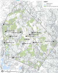
Lexington was first settled as part of Cambridge, Mass. What is now Lexington was then incorporated as a parish, called Cambridge Farms, in 1691. Lexington was incorporated as a separate town in 1713, and is thought to been given its name by Joseph Dudley, then Governor of New England, to honor his relative, English diplomat, Robert Sutton, 2nd Baron Lexington.1 Lexington has 16 USGS-listed hills (15 summits plus one cliff). Four are outside the Boston Basin Hills sruvey area. Only Quincy has more, and it has most of the named hills in the Blue Hills Reservation within its borders. Lexington has no similar park. Lexington does have April 19, 1775. The day that skirmishes between British regulars and American provincials marked the start of the Revolutionary war. Many of the hills in Lexington have a connection to that day. Belfry Hill, where the ringing of the bell aroused the citizens. Granny Hill, which the town attempted to rename Hancock Heights to honor John Hancock, who lived in Lexington in his youth. Loring Hill, named for early residents of Cambridge farms, Joseph Loring house was burned down by the British. Merriam Hill, also named for early residents of Cambridge Farms. British troops marched over it on the way to a battle at Meriam Corner in nearby Concord. Mount Independence, so named in 1824. And finally, Munroe Hill, above Munroe Tavern, a meeting place for colonials, and then temporarily occupied by the British during the battle. |
| Three of other USGS-listed hills are discussed in Charles Hudson’s definitive history of Lexington written in the late 1800s. Bucks Hill, named for David Fiske’s prowess in hunting a deer at the location. Mount Ephraim for the son of Edward Winship, and early settler. Robinson Hill for a merchant from Boston, supplanting the name Davis’s Hill for an early inn holder. Hudson discusses the successful nautical career of Larkin Turner, and his move to Lexington in 1840, but not the location of his home at the base of Turner Hill. |
| The naming of Cranberry Hill, located on the western border with Lincoln, Mass., is obscure. A Frederic A. Hayden is credited with having a cranberry farm in Lincoln in 1830.3 It is not known if there is a family connection, but a Linthrop Hayden of South Carver, Mass. in 1892 invented a cranberry separator machine.4 How Fullers Hill got its name is not known. Lexington has a neighborhood named Fuller Heights, and Fuller Rd., but none are near each other. Katahdin Hill, in the early 1900’s, Benjamin Heald tapped the water from a spring on a hill in Lexington to sell in Boston. A native a Maine, he named his water company, Katahdin Spring Water after the mountain near his birthplace. Whipple Hill, named for Joseph Reed Whipple, who owned a produce and dairy farm in the late 1800s. |
|
|
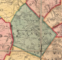
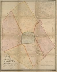
| Lexington Maps |
| • |
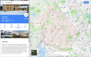
Lexington - Google Maps, Terrain |
| • |
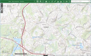
Lexington - MassMapper MassGIS |
| • |
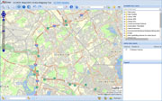
Lexington - USGS - The National Map |
| • |
Concord Quadrangle - 2018 (60 MB PDF) - USGS Topo Download |
| • |
Lexington Quadrangle -: 2018 (60 MB PDF) - USGS Topo Download |
| • |
A Map of the Town of Lexington Middlesex County, Mass., Surveyed by Order of the Town, H.F. Walling, 1853 - Norman B. Leventhal Map Center, Boston Public |
| • |
Period & Area Guide Maps - c.1641-1906 - Lexington Comprehensive Cultural Resources Survey |
| • |
Topography, pg. 5 (PDF) - Town of Lexington Open Space and Recreation Plan Update 2015 |
| • |
Worthen Collection - Cary Memorial Library |
| • |
Lexington Maps: 36, 37, 38, Atlas of Middlesex County, Volume 2, published by Geo. W. Walker & Co., 1906 - State Library of Massachusetts |
| • |
Atlas of the Boundaries of the Cities of Cambridge, Somerville, Waltham and Towns of Belmont, Burlington, Lexington, Watertown, Middlesex County, 1903 - State Library of Massachusetts |
| • |
MapJunction |
|
|
| Lexington Sources |
| • |
History of the Town of Lexington, Middlesex County, Massachusetts, from its First Settlement to 1868, with a Genealogical Register, Charles Hudson, 1868 - Internet Archive |
| • |
History of the Town of Lexington, Middlesex County, Massachusetts, from its First Settlement to 1913, Vol. 1 (History), Charles Hudson, 1913 - Internet Archive |
| • |
History of the Town of Lexington, Middlesex County, Massachusetts, from its First Settlement to 1868 Vol. 2. (Genealogies), Charles Hudson, 1868 - Internet Archive |
| • |
Lexington, History of Middlesex County, Massachusetts, with Biographical Sketches of Many of its Pioneers and Prominent Men, Duane Hurd, 1890, Vol. 1 - Internet Archive |
| • |
Lexington, History of Middlesex County, Massachusetts: Containing Carefully Prepared Histories of Every City and Town in the County, Samuel A. Drake, 1880, Vol. 2 - Internet Archive |
| • |
Town of Lexington Open Space and Recreation Plan Update 2015, (PDF) - Town of Lexington |
| • |
Lexington, MHC Reconnaissance Survey Town Report (PDF), 1980 - Massachusetts Historical Commission |
| • |
Lexington Reconnaisance Report, Freedom's Way Landscape Inventory (PDF), 2006 - State of Massachusetts |
| • |
Lexington: From Liberty's Birthplace to Progressive Suburb, Richard Kollen, 2004 - Google ebook preview |
| • |
Becoming Lexington, Charlie Bowen |
|
|
|
|