| Hills of Braintree, Mass. |
| | Hills | More about Braintree's USGS-listed hills | Maps | Sources | |
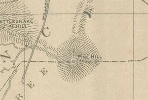
| Pine Hill |
| • |
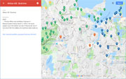
USGS identified - MassMapper MassGIS |
| • |
Google Maps | Google Earth - Google |
| • |
Pine Hill , Map of the city of Quincy, Norfolk County, Massachusetts, Ernest W. Branch, Civil Engineer, 1907 - Norman B. Leventhal Map Center, Boston Public Library |
| • |
Pine Hill, Map of Norfolk County, Massachusetts, Smith & Bumstead, 1858 - Library of Congress |
| • |
Pine Hill - USGS Geographic Names Information System |
|
| Whites Hill |
| • |
USGS identified - MassMapper MassGIS |
| • |
Google Maps | Google Earth - Google |
| • |
The White Family of Weymouth and Braintree, "...Thomas White was admitted a freeman of Massachusetts Colony,
March 3, 1635-6. His name appears upon the earliest records of Weymouth, and,
if not one of the first settlers, he must have been nearly so. ...", The Vinton Memorial, John A. Vinton, pg. 365, 1858 - HathiTrust |
| • |
"...The White family of which we write is largely represented in colonial New England. They were extensive land-owners and generally successful agriculturists. It may be truly said of them, in summing up their general characteristics, that they abstained from the allurements of the vices of the day in which they lived. ...", Hurd, pg. 139, 1884 - Internet Archive |
| • |
"...Whites Hill - In the east part of Braintree, on the east summit of Whites or Pynchorns hill...", Triangulation in Massachusetts, Volume 4, pg. 235, 1922 - Google News Archives |
| • |
Naaman L. White (1813-1890), "...In addition to his two terms in the legislature, White is also recorded as holding numerous local offices in Braintree, including those of town selectman, town assessor, overseer of the poor and supervisor of highways..." - American Political History |
| • |
Whites Hill - USGS Geographic Names Information System |
|
| Wyman Hill |
| • |
USGS identified - MassMapper MassGIS |
| • |
Google Maps | Google Earth - Google |
| • |
"...There is a locality in East Braintree...at the foot of Wyman's Hill and facing the Weymouth Fore-river...". The New English Canaan of Thomas Morton, Volume 14, pg. 216, 1883 - Google ebook |
| • |
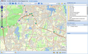
Wymans Hill - Braintree and West Corners Village, Massachusetts Town Map, Comstock & Cline, 1876 - Old Maps |
| • |
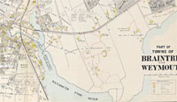
Atlas of Braintree and Weymouth, Massachusetts, Index Map, Walker Lithograph Co., 1909 - State Library of Massachusetts |
| • |
Wymans Hill - Atlas of Braintree and Weymouth, Massachusetts, Index Map, Walker Lithograph Co., 1909 - State Library of Massachusetts |
| • |
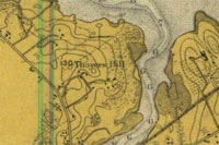
Thayers Hill - Boston Harbor Chart, 1918, Historical Map & Chart Collection - NOAA |
| • |
Wymans Hill - Atlas of Braintree and Weymouth, Massachusetts, pg. 99, Walker Lithograph Co., 1922 - State Library of Massachusetts |
| • |
Wyman Hill - USGS Geographic Names Information System |
|
|
|
|
|
| More about Braintree's USGS-listed hills |
|
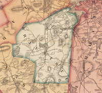
The modern-day town of Braintree is the middle precinct of the larger colonial town that spilt off Quincy in the north, and Randolph and Holbrook in the south.
Two of Braintree's USGS listed summits, Pine Hill (246 ft.) and Whites Hill (174 ft.). are on the eastern end of the Blue Hills range, but neither are in the Blue Hills Reservation, and both have been heavily developed. Thousands of commuters a day drive through the “Braintree split” carved out of eastern side of Pine Hill. An office park has levelled the western side. |
| The White family in the area dates to the first settlers. In 1636, Thomas White was admitted as a freeman in Weymouth. His son, Captain Samuel White (b. 1642), was a major owner of land on both sides of the Monatiquot River in Braintree.1 Later descendant Naaman L White (b. 1814), held office in Braintree as a selectman, assessor, overseer of the poor, and surveyor of highways. A lawyer by training, Naaman was “particularly averse to what lawyers call ‘fancy actions’.”2 In 2015, approval was given for a new subdivision on Whites Hill.3 |
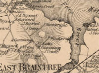
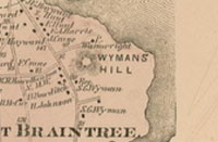
| USGS listed Wymans Hill (125 ft.) is shown in the 1876 Comstock & Cline map of Braintree4 near the estate of an S.G. Wyman on the banks of the Fore River. There is little information available online on anyone named Wyman in Braintree, Quincy, or Weymouth. In 1640, two Wyman brothers, Francis and John Wyman, together with three uncles, signed orders establishing the town of Woburn north of Boston.5 A 1909 map of area6 shows three large estates owned by, William H. Wainwright, J.S. Kendall, and Thomas A. Watson. The latter is the Watson of the famous line spoken by Alexander G. Bell, "Mr. Watson, come here, I want you!" fame. |
| Thomas Watson moved to the 60-acre farm on the Fore River in Braintree when he was 27 years old – Wymans Hill. By that time he had about 40 U.S. patents and had stopped working on developing the telephone. While in Braintree he started a marine engine company on 100 acres of land at Quincy Point. That business evolved into the Fore River Shipyard. He also was a prominent figure in improving the public-school system, and in the creation of the town’s electric light company.7 |
|
|
| Braintree Maps |
| • |
Braintree - Google Maps, Terrain |
| • |
Braintree - MassMapper MassGIS |
| • |
Braintree - USGS - The National Map |
| • |
Weymouth Quadrangle - 2018 (60 MB PDF) - USGS Topo Download |
| • |
Blue Hills Quadrangle - 2018 (60 MB PDF) - USGS Topo Download |
| • |
Map of the town of Braintree, Norfolk County, Mass., Henry F. Walling, 1856 - Library of Congress |
| • |
Atlas of Braintree and Weymouth, Massachusetts, Walker Lithograph Co., 1909 - State Library of Massachusetts |
| • |
Map of Norfolk County, Massachusetts, Henry F. Walling, 1853 - Library of Congress |
| • |
Map of Norfolk County, Massachusetts, Smith & Bumstead, 1858 - Library of Congress |
| • |
Blue Hills Reservation; Massachusetts, E.G. Chamberlain,1885 - Olmstead Archives, NHS, NPS |
|
|
| Braintree Sources |
| • |
A History of old Braintree and Quincy, with a Sketch of Randolph and Holbrook, William F. Pattee, 1878 - Internet Archive |
| • |
Records of the Town of Braintree, 1640-1793, Samuel A. Bates, 1886 - HathiTrust |
| • |
History of Braintree, Massachusetts, the North Precinct of Braintree, and the Town of Quincy, Charles F. Adams, 1891 - Internet Archive |
| • |
A Brief History of the Town of Braintree in Massachusetts, Marion S. Arnold, 1940 - HathiTrust |
| • |
Braintree, MHC Reconnaissance Survey Town Report (PDF), 1979 - Massachusetts Historical Commission |
| • |
Braintree, History of Norfolk County, Massachusetts, with Biographical Sketches of Many of its Pioneers and Prominent Men, Duane Hurd, 1884 - Internet Archive |
| • |
Braintree, History of Norfolk County, Massachusetts, 1622-1918, Louis A. Cook, Vol. 1, 1918 - Internet Archive |
|
|
| Footnotes |
| 1 |
Vinton, pg. 365, 1858 - HathiTrust |
| 2 |
Hurd, pg. 139, 1884 - Internet Archive |
| 3 |
Whites Hill Estates subdivision approved with 78 conditions, Jan. 14, 2015 - Wicked Local Braintree |
| 4 |
Braintree and West Corners Village, Massachusetts Town Map, Comstock & Cline, 1876 - Old Maps |
| 5 |
Genealogy of the Wyman family from its first settlement in America to the present date, August, 1883, Clark E. Wyman, 1883 - Internet Archive |
| 6 |
Atlas of Braintree and Weymouth, Massachusetts, Plate 4, Walker Lithograph Co., 1909 - State Library of Massachusetts |
| 7 |
Thomas Waston - Braintree Electric Light Department |
|
|