| Hills of Brookline, Mass. |
| | Hills | More about Brookline's USGS-listed hills | Maps | Sources | |
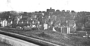
| Aspinwall Hill |
| • |
USGS identified - MassMapper MassGIS |
| • |
Google Maps | Google Earth - Google |
| • |
"...
Here Peter Aspinwall lived and died. He was a farmer, and, judging by the inventory of his estate, taken after his death, which included a tanning outfit, he probably carried on also the tanning business. He does not appear to have been very conspicuous in public affairs, but held several town offices..." - The Aspinwall Genealogy, pg 18, Algernon A. Aspinwall, 1901 - Internet Archive |
| • |
"...From the early years of the settlement of Muddy River until the last decade of the nineteenth century, the name Aspinwall has been conspicuous in the annals of Brookline...." - Denehy, pg 88, 1906 - HathiTrust |
| • |
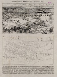
Aspinwall Hill & Beaconsfield Terraces, "...Aspinwall Hill, the smaller cousin to Brookline's other prominent landmass, Corey Hill, rises up amidst the encircling Beacon, Washington, Tappan, and Greenough Streets. Bearing the name of one of the oldest Brookline families, the roughly 87 acres of land were owned, sold, engineered. and subdivided by subsequent generations of this ambitious family..", Linda O. Pehlke - Brookline Historical Society |
| • |
The Aspinwall Family of Muddy River, now Brookline Mass., pg. 342, Edward A. Bowen, The New England Historical and Genealogical Register, Vol. 47, 1893 - Google ebook |
| • |
Photo Collection, Aspinwall Hill - Brookline Historical Society |
| • |
Aspinwall Hill - USGS Geographic Names Information System |
|
| Babcock Hill |
| • |
Google Maps | Google Earth - Google |
| • |
North Brookline, "...George Babcock purchased the Devotion farm in 1827....Amongst this verdant countryside, a heavily wooded Babcock Hill rose up next to Babcock Pond and the swampy land that surrounded it. Smelt Brook drained the swamp, making its way northeast to the Charles River...When the electric trolley began to rumble down the newly widened Beacon Street in the late 1880s, Babcock Hill's sand and gravel were used to fill in the pond and swamp, creating buildable land..", Linda O. Pehlke - Brookline Historical Society |
| • |
Walking Tour: The Devotion House, Babcock Farm, and McKayville, "...In 1827 the farm was acquired by George Babcock. He was something of an eccentric, wearing a stovepipe hat winter and summer and priding himself on being first at the Boston market with his spring peas (which other farmers swore he planted by punching holes with a crowbar in the still frozen ground....", - Brookline Historical Society |
|
| Bradley Hill |
| • |
Google Maps | Google Earth - Google |
| • |
"...Benjamin Bradley, afterwards an extensive landowner on Bradley Hill, Boylston Street, and a man who seems to
have delighted to shock the sensibilities of his conventional neighbors, in afterlife, "saved the life of a woman and child by mounting a long ladder and taking them from an upper window.".." - Denehy, pg 92, 1906 - HathiTrust |
|
| Corey Hill |
| • |
USGS identified - MassMapper MassGIS |
| • |
Google Maps | Google Earth - Google |
| • |
"...The Coreys became an important family in Brookline, and gave their name to Corey's Hill. Captain Timothy Corey, of Weston, purchased land from the White family, and settled in the town just before the Revolution..." - Denehy, pg 102, 1906 - HathiTrust |
| • |
"...Corey was in active service in the Revolutionary War, and was one of three who were all that were left of an entire company who died of wounds, sickness, and imprisonment...Captain Corey is remembered as an old gentleman who dressed in the costume of the last century, as long as he lived, wearing a 'three-cornered cocked hat'..." - Woods, pg 181, 1874 - Internet Archive |
| • |
"...This area is framed and dominated by Corey Hill, rising 260 feet above sea level, known in the early settlement period as 'The Great Hill.'..." - Hardwicke, Reed, pg 97, 1999 - Internet Archive |
| • |
The Corey Estates, "...The greater portion of the land beyond Beacon street southwest of the crown of Corey Hill to the Brighton line, was formerly owned by the Corey families of the town. The first of that name to acquire and settle upon it was Timothy, son of Isaac of Weston, who came to Brookline when a young man, married Elizabeth Griggs, and spent the remainder of his days in town..." - Proceedings Brookline Historical Society, 1905 - Brookline Historical Society |
| • |
Timothy Corey Tomb, Walnut Street Cemetery - About Brookline |
| • |
Corey Family Genealogy, George F. Candage, 1911 - Internet Archive |
| • |
Photo Collection, Corey Hill - Brookline Historical Society |
| • |
Corey Hill - USGS Geographic Names Information System |
|
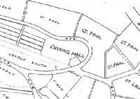
| Cushing Knoll |
| • |
Google Maps | Google Earth - Google |
| • |
Historic Figures "...On a prominent knoll in Holyhood Cemetery, surrounded by red roses, Rose Kennedy lies beside her husband, Joseph P. Kennedy, former Ambassador to Great Britain and patriarch of the huge and famous Kennedy clan..." - Holyhood Cemetery Association |
| • |
Richard Cushing, "...Richard James Cushing (1895–1970) was an American prelate of the Roman Catholic Church. He served as Archbishop of Boston from 1944 to 1970, and was created a cardinal in 1958....The Cardinal was a close friend of the Kennedy family. He officiated at the marriage of John F. Kennedy and Jacqueline Lee Bouvier in 1953, at which he also read a special prayer from Pope Pius XII, and baptized many of the Kennedy children. Cushing gave the prayer invocation at Kennedy's inauguration in 1961. The Cardinal also celebrated President Kennedy's funeral Mass in 1963 at St. Matthew's Cathedral in Washington, D.C...." - Wikipedia |
|
| Dane Park |
| • |
Google Maps | Google Earth - Google |
| • |
Dane Park, "...Dane Park ... contains a variety of volcanic formations including a lava dome that was formed when molten lava was hurled out of an active volcano, and lava pillows that resulted when hot lava flows reached the edge of existing dry land and dropped into the sea. A geology trail with informational signs was established in 2001..." - Brookline Recreation |
| • |
Volcanics in Dane Park, Brookline, "..One place where evidence of these volcanoes remains is in Dane Park in Brookline. Here you can see rocks formed from ancient ash deposits (tuff) and other rocks formed from cooling lava flows (basalt)..." - Boston Geology |
| • |
In Memoriam - Ernest B. Dane, "...Ernest B. Dane was born in Brookline, Massachusetts, on October 17, 1868...he entered the office of a trustee in Boston, where he remained for thirteen years. In 1905 he became a director of the Brookline Trust Co., of which he later became president. A man of wealth by inheritance, he early became interested in many large corporations in various parts of the country..." - Cambridge University Press |
| • |
Dane Estate - The History, "...In 1891, 'Roughwood' as it was first named, was built and owned by Major William Cox and is now known as The Dane Estate at Pine Manor College...In 1904, the Dane family purchased the estate and all its buildings, and over the years acquired additional land until the estate totaled 120 acres..." - The Dane Estate |
| • |
Roughwood, "...A history of 'Roughwood' should start back in the early 1880's when all this property was known as Brookline Woodlands and was owned by one Thomas Gaffield..", Edward Dane, 1961 - Brookline Historical Society |
|
| Fisher Hill |
| • |
USGS identified - MassMapper MassGIS |
| • |
Google Maps | Google Earth - Google |
| • |
Fisher Hill, "...Also known as Brookline Hill, Mount Vernon, and Henshaw Hill, it was ultimately named after Francis Fisher, a Boston merchant whose 1852 estate was built at the corner of Boylston Street and Chestnut Hill Avenue..." - Brookline Historical Society |
| • |
Fisher Hill, Places: Past and Present, Linda O. Pehlke, 2005 - Brookline Historical Society |
| • |
"...Mr. Francis Fisher purchased the original Ackers house in 1850, pulled it down, built a fine mansion, and gave his name to the hill..." - Denehy, pg 92, 1906 - HathiTrust |
| • |
"...Francis Fisher commenced his business life as clerk in the store of his brothers, Josiah and Freeman, in Dedham. In 1819, he was admitted into partnership with Henry Hovey & Company, 23 Central Wharf, Boston, which later became the firm oif Fisher & Company, 23 and 24 Central Wharf, Boston. The
firm was originally established in 1810 for the purpose of importing cotton cloths from Calcutta, and as commission merchants in Virginia flour and tobacco..." - The Fisher Genealogy, pg 274, Philip A. Fisher, 1898- Internet Archive |
| • |
Fisher Hill - USGS Geographic Names Information System |
|
| Goddard Heights |
| • |
Google Maps | Google Earth - Google |
| • |
Larz Anderson Historic Park District, "...The land which makes up this town-owned park of almost 62 acres was once the property
of the Goddard family and during the Revolution was known as Goddard Heights...
...Isabel Perkins Anderson, grand daughter of William Fletcher Weld, I, founder of one the world's largest fleet of clipper ships, and cousin of William Fletcher Weld, II, was married to Larz Anderson who served as an ambassador of the United States during the administrations of Presidents Harrison and Taft..." - Massachusetts Historical Commission Information System (MACRIS) |
| • |
Larz Anderson Park, "...The land was the property of the Goddard family during the Revolutionary War. William Fletcher Weld purchased it between 1841 and 1881 to create 'Windy Top,' his country estate..." - Town of Brookline |
| • |
John Goddard House, "...In 1872 Abiiah Goddard had had his land surveyed in order to sell 56 acres of the high ground to the west to Samuel Shackell of Boston, who subdivided it into 171 lots and, at least on plans and in the 1874 Atlas, laid out a number of new streets. This subdivision, on both sides of Goddard Ave., was called Goddard
Heights..." - Massachusetts Historical Commission Information System (MACRIS) |
| • |
"...William F. Weld built the first large summer house on the hill that is now Lars Anderson Park..." - Hardwicke, Reed, pg 46, 1999 - Internet Archive |
|
| Green Hill |
| • |
Google Maps | Google Earth - Google |
| • |
"...[Senator George Cabot]...to possess himself of a country place that should be pleasing to him both for its beauty and for its other advantages, and being greatly attracted by the pretty situation and extensive domain of the old Nehemiah Davis place, he gladly purchased it, and at once bestowed upon it the name of 'Green Hill,' a title which the present occupant has had great pleasure in trying to preserve, as a remembrance both of Senator Cabot and also of the aged house itself, which has been beloved by all who have occupied it for any length of time...", Proceedings Brookline Historical Society, 1903 - Brookline Historical Society |
| • |
George Cabot, "...He was elected to the US Senate and served from March 4, 1791 to June 9, 1796. He was a supporter of the financial policies of Alexander Hamilton and became a Federalist when the party was organized. In 1793, he was named a director of the First Bank of the United States. In 1798, Cabot was appointed to but declined the position of the first US Secretary of the Navy...." - Wikipedia |
| • |
Green Hill District, "...The history of land ownership here begins with an eighty acre allotment to Captain John Underhill in 1636. One of the first deputies from Boston to the General Court; an early officer of the Ancient and Honorable Artillery Company; and the first recorded visitor to Muddy River, sent to disperse ten sagamores and many Indians.Underhill was charged with antinomian heresy, forced to sell his holdings, and driven to New Hampshire in 1638..." - Massachusetts Historical Commission Information System (MACRIS) |
| • |
"...As a result of his frequent penchant for challenging authority and inciting disorder, Underhill was eventually banished from three colonies...", John Underhill: A Psychological Portrait of an Indian Fighter, 1597-1672 (PDF), Laurence M. Hauptman - Hudson Valley River Institute |
|
| Heath Hill |
| • |
Google Maps | Google Earth - Google |
| • |
"...Miss Eadith de C. Heath was the daughter of the late Charles Henry Heath, and for their family, one of the oldest in Brookline, both Heath Street and Heath Hill were named...", Annual Meeting Proceedings, 1924 - Brookline Historical Society |
| • |
Ebenezer Heath House, "...In 1782 , the property was purchased by John Heath, Sameul Sewall's cousin, who lived in Brookline as early as 1762 at which time he was a fence viewer..." - Massachusetts Historical Commission Information System (MACRIS) |
| • |
Edith deC. Heath House, "...This is one of four houses surveyed so far that were designed by the architect Lois L. Howe (1864-1964). A graduate of the architectural course at MIT, she was the first licensed woman architect in the country..." - Massachusetts Historical Commission Information System (MACRIS) |
|
| Mount Walley |
| • |
USGS identified - MassMapper MassGIS |
| • |
Google Maps | Google Earth - Google |
| • |
"...The hill on which this house stands was one of the outposts of Washington's line of circumvallation around Boston when he besieged the British army there during the Revolution. A house stood here at that time and the hill has long been known as Mount Walley, from the Hon. Samuel H. Walley, who at one time owned the house and estate.." - Denehy, pg 41, 1906 - HathiTrust |
| • |
Samuel H. Walley, "...Samuel Hurd Walley (August 31, 1805 – August 27, 1877) was a Massachusetts businessman and politician who served as Speaker of the Massachusetts House of Representatives and as a member of the U.S. Representative from Massachusetts....Walley engaged in banking, he took a prominent part in the organization of the Suffolk Savings Bank. Walley was involved in the creation of the Revere National Bank, and from 1870 until his death he served as its first President. Walley was involved in railroad development he was the Treasurer of the Vermont Central Railroad, treasurer of the Ogdensburg railroad and a promoter and first treasurer of the Wisconsin Central Railroad..." - Wikipedia |
| • |
Mount Walley - USGS Geographic Names Information System |
|
| Pill Hill |
| • |
Google Maps | Google Earth - Google |
| • |
Pill Hill, Brookline, Massachusetts, "...Pill Hill in Brookline was nicknamed for the large numbers of doctors in the neighborhood.That was likely due to its proximity to hospitals in the Longwood Medical and Academic Area of Boston. "High Street Hill" is the older and more formal name for the neighborhood.." - Wiklpedia |
| • |
"...Pill Hill, or High Street as is was more formally called, assumed its present configuration in 1884...the name Pill Hill derives from the number of doctors who lived here in the early 20th century..." - Hardwicke, Reed, pg 51, 1999 - Internet Archive |
| • |
Pill Hill & The Point, "...ill Hill was one of America's very first suburbs, and like others of its kind, it evolved out of a convergence of cultural and economic forces that swept the nation as it recovered from the Civil War..", Linda O. Pehlke - Brookline Historical Society |
|
| Single Tree Hill |
| • |
USGS identified - MassMapper MassGIS |
| • |
Google Maps | Google Earth - Google |
| • |
"...In the beautiful garden suburb of Brookline...stands the notably elegant summer residence of Colonel Theodore Lyman. This estate belonged at the beginning of the century to a Mr. White, who sold it to Mr. Jonathan Mason. It then comprised three hundred acres, but the estate was afterwards cut in two by the old Boston and Worcester turnpike. A picturesque hill that rises above the house was called 'Single Tree Hill' from a large solitary tree which grew on its summit and was years ago, a landmark for vessels coming into Boston Harbour.." - The Art Journal, No. 4, pg. 132, 1878 - Google ebook |
| • |
"...At 340 feet, Single Tree (also known as Lyman) Hill is the highest point in Town..". Brookline Open Space Plan, (PDF), 2010 - Town of Brookline |
| • |
"...the land rises gradually into the interior of the town until it reaches Single-Tree Hill (aka, Lyman's or Cabot's), 336 feet elevation...", Brookline, MHC Reconnaissance Survey Town Report (PDF), 1980 - Massachusetts Historical Commission |
| • |
"...Hon. Theodore Lyman, at that time well known as a public man, philanthropist and legislator,
purchased in 1841, the old White house and estate on Heath Street, beyond Warren, which had been occupied by Hon. Jonathan Mason earlier in the century. He pulled down the old house and erected a modern mansion, and greatly of Brookline, and occupies a fine residence and estate on Boylston Street, opposite the west end of the Brookline Reservoir.." - Denehy, pg 98, 1906 - HathiTrust |
| • |
"...Theodore Lyman Jr. was mayor of Boston in 1834-35...He first owned a country estate in Waltham; and it was not until 1842 that he began a new country house on Singletree Hill in Brookline...", Hardwicke, Reed, pg. 112, 1999 - Internet Archive |
| • |
"...Samuel Cabot began to acquire land for himself in Brookline before 5 Sept. 1845 for on that date he bought for$1,142.81, seven acres of land adjoining his previous holdings and also those of Thomas H. Perkins...Mrs. Samuel Cabot writes to her son Elliot, 'Your father has gone to Brookline, not to enjoy its beauties but to save his taxes.'.. " - History and Genealogy of the Cabot family, 1475-1927, pg. 296, Vernon L. Briggs, 1906 - HathiTrust |
| • |
Cabot Family, "...From John Cabot's grandson, Samuel Cabot's side, Samuel Cabot Jr. (b. 1784 in Boston) furthered the family fortune by combining the first family staples of working in shipping and marrying money..." - Wiklpedia |
| • |
Samuel Cabot, Jr., "...He entered the China Trade in 1817, in yet another family partnership, with his Perkins in-laws. He retired from business in 1838, one of the richest merchants in New England..." - Wiklpedia |
| • |
"...The estate owned in 1700 by Deacon Benjamin White is now the property of Hon. Jonathan Mason, a wealthy Boston gentleman, who lives here in summer, and in Boston during the winter...", John White of Muddy River and Descendants of his son Benjamin, pg. 6, 1897 - Internet Archive |
| • |
Jonathan Mason (1756-1831), "...Senator and a Representative from Massachusetts; born in Boston, Mass., September 12, 1756...elected as a Federalist to the United States Senate to fill the vacancy caused by the resignation of Benjamin Goodhue and served from November 14, 1800, to March 3, 1803..."- Biographical Directory of the U.S. Congress |
| • |
Jonathan Mason - Wikipedia |
| • |
Three Glimpses of Brookline, in 1700, 1800, and 1900, No. 11, pg. 6, "...The estate owned in 1700 by Deacon Benjamin White is now the property of Hon. Jonathan Mason, a wealthy Boston gentleman, who lives here in summer, and in Boston during the winter...", Marion L. Sharp, Brookline Historical Publication Society, 1897- HathiTrust |
| • |
White Place Historic District, "...The Whites were an old Brookline family; the first generation was represented by John White who traveled from England to Watertown in 1638 and settled in Muddy River in 1650. John White was one of the larger landowners in town who had obtained his property through purchase..." - Massachusetts Historical Commission Information System (MACRIS) |
| • |
Single Tree Hill - USGS Geographic Names Information System |
|
| Skyline Park |
| • |
Google Maps | Google Earth - Google |
| • |
Skyline Park, "...Skyline Park is situated on the top and sides of a gently sloping hill, allowing for scenic views of the surrounding area....The location is the site of the former town landfill, the Newton Street Landfill, which was capped and the land reclaimed for a public park..." - Brookline Recreation |
|
| Walnut Hill |
| • |
USGS identified - MassMapper MassGIS |
| • |
Google Maps | Google Earth - Google |
| • |
Walnut Hill Area, "...The Walnut Hill neighborhood has its origins in the Goodnough family farm, which occupied the land between the South Street intersection with Newton Street, on the north, and the West Roxbury line, on the south. In 1875, Xanthus Goodnough, a farmer, and his brother, George W. Goodnough, owned two adjacent parcels totaling about 88 acres at this location. The farmhouse of Xanthus Goodnough, which appears to be the oldest dwelling extant on Walnut Hill..." - Massachusetts Historical Commission Information System (MACRIS) |
| • |
X. Henry Goodnough, "...X. Henry Goodnough, (1860–1935), engineer, was chairman of Boston's Metropolitan Water District in the 1920s and chief advocate for creation of the Quabbin Reservoir project. Goodnough Dike was named for him... the son of Xanthus Goodnough, a farmer and native of Newton, and his wife, Kate (Hurley) Goodnough, a native of New Brunswick, Canada..." - Wiklpedia |
| • |
"...Another house, which in years gone by occupied a prominent position and was the home of wealth and culture, and which last winter was destroyed by fire, was the Denny house on the top of the hill, (formerly known as Walnut Hill), and which was built and occupied by Francis C. Denny in 1871-72. This house was magnificently located, commanding a most extensive view, with the large farm of 137 acres immediately surrounding the mansion..", President's Address, Annual Meeting, January 23, 1913 - Brookline Historical Society |
| • |
Walnut Hill - USGS Geographic Names Information System |
|
|
|
 |
|
| Aspinwall Hill |
 |
|
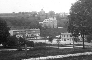
| Corey Hill |
 |
|
 |
|
 |
|
| Cushing Knoll |
 |
|
| |
| |
| |
| |
| |
|
|
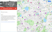
| More about Brookline's USGS-listed hills |
|
In 1630 the land in the Boston Basin that would become Brookline was just west across a marsh from where the Puritans had settled on the Shawmut Peninsula. To get there by road, in 1633 authority was given to build two cart-bridges over the rivers they named Stony River and Muddy River.1 The later would become the first name for the area. In the late 1800’s, the Muddy River would get transformed into the parks and waterways of Fredrick L. Olmsted’s Emerald Necklace. The Stony River did not have the same fate. It now runs through a 7.5-mile culvert from the Stony Brook Reservation in Hyde Park to an outfall along the Muddy River in the Fenway. In 1705 the hamlet of Muddy River was incorporated as the town of Brookline. It took its name from one of the three John Hull/Samuel Sewall farms, Brooklin, Swamplin, and Hogs-Coat. The later had a border with the town of Cambridge that included Smelt Brook.2 John Hull (1624-1683) and a partner had established the first mint in America producing “Pine Tree Shillings”. Hull was a Selectman in Boston, served as treasurer, was on the General Court, and was active in shipping. He married Judith Quincy (626-1695), the daughter of Judith Pares and Edmund Quincy, the founders of the Quincy family in America.3 Samuel Sewall (1652-1730), best known for his later involvement as a judge in the Salem witch trials, married John Hull’s daughter and only child Hannah, so inherited the “Brooklin” farm when John Hull died.4 |
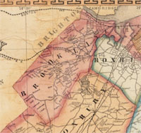
| Brookline has six USGS listed hills, Aspinwall Hill (246 ft.), Corey Hill Outlook (262 ft.), Fisher Hill (266 ft.), Mount Walley (308 ft.), Single Tree Hill (322 ft.), Walnut Hill (194 ft.) |
| Aspinwall Hill (246 ft.) is named for the Aspinwall family, one of the oldest in Brookline. In 1650 Peter Aspinwall purchased a farm in Muddy River from William Colborne, one of the people who first received an allotment of land there.5 Colborne had been on the committee set up to build the first bridge over the Muddy River, linking Boston to the new farming land.6 He also was on the committee to allocate land in Muddy River to worthy citizens from Boston.7 Also on the committee was William Aspinwall. It is thought he might have been a cousin or possibly brother to Peter Aspinwall. William is recorded as emigrated to Boston with John Winthrop’s fleet in 1630. He was a skilled surveyor and Deputy to the General Court. Trusted as a keeper of records, much of what is known about Boston at that time is based on his Book of Possessions8 and Notarial Records.9 Those records show that William earlier had owned land in Muddy River. But, William’s non-conformist religious views got him in trouble with the Puritan hierarchy. He was banished from Boston in 1638, rehabilitated his relations with the Boston authorities, ran afoul again 1652 and returned to England. The descendants of Peter Aspinwall prospered. His sons Eleazar and Samuel were signers of a petition to authorities in Boston that eventually granted gave Muddy River independence, and its name Brookline.10 |
| Corey Hill (259 ft.) is named for Timothy Corey, he purchased land in Brookline in 1771. Born in Weston, he was at the Battle of Lexington during the Revolutionary War. He and his sons were active in the Baptist Church in Brookline. In 1852, Francis Fisher built an estate on what had been known as Brookline Hill, Mount Vernon, and Henshaw Hill. His firm, Fisher & Co., was originally established in 1810 for importing cotton cloths from Calcutta, and Virginia flour and tobacco. Samuel H. Walley was a Massachusetts businessman and politician who served as Speaker of the Massachusetts House of Representatives and as a member of the U.S. Representative from Massachusetts. |
| Single Tree Hill (322 ft.) could have been named by any one of several prominent families who owned the land on or near the hill. First would be John White, he emigrated to Watertown in 1638, and then moved to Muddy River in 1650, eventually buying over 300 acres of land. His two sons were signers of the petition for the creation of an independent town. Next would be Jonathan Mason, Jr., in 1792 he purchased the estate of John White descendant, Deacon Benjamin White, and used it for a summer house. His father, Jonathan, Sr. was a prosperous merchant in Boston, Deacon of the Old South Church, and active in the Sons of Liberty during the Revolution.11 Jonathan, Jr. was a lawyer, entrepreneur, public official, becoming a U.S. Senator elected as a Federalist. |
| In 1799 Thomas H. Perkins purchased 53 acres of land near the hill from John White’s descendant, Moses White. Dubbed the ‘Merchant Prince of Boston’.12 Thomas was a wealthy Boston merchant whose philanthropy helped start the Boston Museum of Fine Arts, Boston Athenaeum, Massachusetts General Hospital, McLean Hospital, and the Perkins School for the Blind was renamed in his honor. Thomas, with his brother James, initially traded flour, horses, dried fish, and slaves. When China opened Canton to foreign business in 1785, the Perkins’ were one of the first Boston merchants to take the risk of trading there. The gamble paid off and the Perkins became wealthy. In 1815 they opened an office in Turkey to buy opium for resale in China. |
| After the Whites, Masons, and Perkins comes the Cabots, by marriage. Thomas H. Perkins’ eldest daughter Elizabeth married Samuel Cabot Jr., of the Boston Brahmin Cabots, and received a portion of the Perkin’s estate in Brookline, and a house. The couple had seven children. |
| The final prominent Bostonian to own a significant portion of Single Tree Hill was Theodore Lyman, Jr., mayor of Boston from 1820 to 1825. In 1841, he purchased the Mason estate, tore it down the house, and built a new mansion. Theodore, Sr. became wealthy in Northwest fur trade and China trade. His summer estate is the Lyman House in Waltham. |
| The final prominent Bostonian to own a significant portion of Single Tree Hill was Theodore Lyman, Jr., mayor of Boston from 1820 to 1825. In 1841, he purchased the Mason estate, tore it down the house, and built a new mansion. Theodore, Sr. became wealthy in Northwest fur trade and China trade. His summer estate is the Lyman House in Waltham.13 |
| It is unclear who named the final USGS-listed summit in Brookline, Walnut Hill (194 ft.). Located on the city’s southern border with Newton and West Roxbury, Walnut Hill is the only named hill in the 1858 H.F. Walling map of Norfolk county. William Tyng initially owned the land, part of his 600-acre allotment granted him in the 1630s ‘Great Allotment’ in Muddy River, the largest single grant. William was a successful English merchant who is said chartered his own ship when he emigrated to Boston in 1638. He was the treasurer of Massachusetts Bay Colony, 1640-44, captain of the Braintree Militia Company. When he died in 1645, his estate was ‘as large as any in the colony for those days.’ It is likely he never lived on the land.14 William had four daughters, as a result, it was descendants of Williams’ brother Edward that provided the ‘Tyng’ in Tyngsborough, Mass. Over the next 200 years the hill had a series of owners, none with a record of naming the hill. The nearby Walnut Hills Cemetery was laid out in 1875, likely taking its name from the already named hill. |
|
|
| Brookline Maps |
| • |
Brookline - Google Maps, Terrain |
| • |
Brookline - MassMapper MassGIS |
| • |
Brookline - USGS - The National Map |
| • |
Boston South Quadrangle - 2018 (60 MB PDF) - USGS Topo Download |
| • |
Newton Quadrangle - 2018 (60 MB PDF) - USGS Topo Download |
| • |
Maps & Atlases - Brookline Historical Society |
| • |
Map of the Town of Brookline, E.F. Woodward, 1844 - Norman B. Leventhal Map Center, Boston Public Library |
| • |
Map of Norfolk County, Massachusetts, Henry F. Walling, 1853 - Norman B. Leventhal Map Center, Boston Public Library |
| • |
Map of Norfolk County, Massachusetts, Henry F. Walling, 1858 - David Ramsey Map Collection |
| • |
Atlas of Brookline, Massachusetts, G.M. hopkins & Co., 1874 - State Library of Massachusetts |
| • |
Atlas of Brookline, Massachusetts, G.W. Bromley & Co., 1927 - State Library of Massachusetts |
| • |
Land Ownership in Brookline, Introduction to Maps, 1636, 1667, 1693, 1746, 1786, 1822, 1844, 1855, 1888, 1916 - Brookline Historical Society |
| • |
Town of Brookline, Mass., Topography - Town of Brookline |
| • |
Map Library - Town of Brookline |
|
|
| Brookline Sources |
| • |
A History of Brookline, Massachusetts, From the First Settlement of Muddy River Until the Present Time; 1630-1906, John W. Denehy, 1906 - HathiTrust |
| • |
Brookline, The History of a Favored Town, Charles K. Bolton, 1897 - Internet Archive |
| • |
Brookline: Images of America, Greer Hardwicke, Roger Reed, 1999 - Internet Archive |
| • |
Historical Sketches of Brookline, Mass., Harriet F. Woods, 1874 - Internet Archive |
| • |
Brookline, History of Norfolk County, Massachusetts, 1622-1918, Louis A. Cook, Vol. 1, 1918 - Internet Archive |
| • |
Publications of the Brookline Historical Publication Society, 1st-2d Series, No. 1-20 - HathiTrust |
| • |
Publications of the Brookline Historical Publication Society, 1897 - Internet Archive |
| • |
A Guide to the Local History of Brookline, Mass., Brookline Education Society History Committee, 1897 - Internet Archive |
| • |
Brookline, History of Norfolk County, Massachusetts, 1622-1918, Louis A. Cook, Vol. 1, 1918 - Internet Archive |
| • |
Brookline, MHC Reconnaissance Survey Town Report (PDF), 1980 - Massachusetts Historical Commission |
| • |
Brookline Multiple Resource Area (PDF), National Register of Historic Places - U.S. National Park Service |
| • |
Uncommon Suburbs: Suburbanization at the Western Edge of Boston, 1820-1873 (PDF), William P. Marchione. Boston College Dissertation, 1994 - Brookline Historical Society |
| • |
Brookline Historical Society |
| • |
About Brookline |
| • |
Open Space Plan - Town of Brookline |
|
|
| Footnotes |
| 1 |
An Address at the Opening of the Town Hall, in Brookline, pg. 10, John Pierce, 1845 - Google ebook |
| |
Water Resources and the Urban Environment, Lower Charles River Watershed, Massachusetts, 1630–2005 (PDF), Peter K. Weiskel, Lora K. Barlow, Tomas W. Smieszek, 2005 - USGS |
| 2 |
Bolton, pg. 83 , 1897 - Internet Archive |
| 3 |
John Hull, the Mint and the Economics of Massachusetts Coinage, Louis Jordan, 2002 - Internet Archive |
| 4 |
History of Samuel Sewall - Samuel Sewall Inn |
| |
Diary of Samuel Sewall - Internet Archive, HathiTrust |
| 5 |
The Aspinwall Genealogy, pg 18, Algernon A. Aspinwall, 1901 - Internet Archive |
| 6 |
More on "Immigrant" Wm. Colburn - Rootsweb, Ancestry.com |
| 7 |
Boston Town Records, Second Report of the Record Commissioners of the City of Boston, 1877, pg. 6 - Internet Archive |
| 8 |
Ibid - Internet Archive |
| 9 |
A Volume Relating to the Early History of Boston, Containing the Aspinwall Notarial Records from 1644 to 1651, City of Boston, 1903 - Internet Archive |
| 10 |
Cook, pg. 91, 1918 - Internet Archive |
| 11 |
Jonathan Mason - Massachusetts Historical Society |
| 12 |
Merchant Prince of Boston, Colonel T.H. Perkins, 1764-1854, Carl Seaburg, Stanley Paterson, 1971 - Internet Archive |
| 13 |
The Vale, Theodore Lyman House - Massachusetts Historical Commission Information System (MACRIS) |
| 14 |
William Tyng, History of the Military Company of the Massachusetts, now called the Ancient and Honorable Artillery Company of Massachusetts, 1637-1888, 1895 - Internet Archive |
| 14 |
The History of New England from 1630 to 1649, Vol. 2, pg. 1643, John Winthrop, 1858 - Google ebook |
| 15 |
Memoirs of Edward Tyng, Esquire, and of Hon. William Tyng, Timothy Alden, 1808 - Google ebook |
|
|