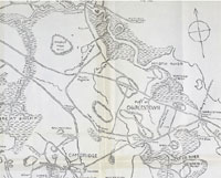
| Hills of Somerville, Mass. |
| | Hills | More about Somerville's USGS-listed hills | Maps | Sources | |
| Seven Hill of Somerville |
| • |
Somerville as a City of Homes, "...In the midst of these surroundings, Somerville rests on her seven hills of historic beauty....", Somerville, Mass., The Beautiful City of Seven Hills, its History and Opportunities, Somerville Board of Trade, 1902 - Internet Archive |
| • |
Seven Hills Park: "...Seven Hills Park, behind the Davis Square Red Line stop, was completed in 1990.... The park commemorates, on large, weathervane-like structures, the Seven Hills of Somerville – named in homage to the legendary Seven Hills of Rome....", 2015 - Bouseblog |
| • |
Seven Hills Park, Somerville, (sculpture): "...Seven sculptures, each installed atop tall metal poles, depict local landmarks. Spring Hill is a black and white cow weathervane; Winter is an apple tree; Walnut is two clock faces; Cobble is a brick mansion; Clarendon is a silver fish (alewife) swimming; Ploughed is a white frame mansion; and Prospect is a replica of the stone fort now standing on Prospect Hill....", Clifford Seibert sculptor, 1990 - Smithsonian Learning Lab |
|
|
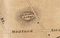
| Adams Ledge |
|
| Central Hill |
| • |
Google Maps | Google Earth - Google |
| • |
"...Central Hill is the site of the high schools. This land is called Middle Hill on some of the old maps of Revolutionary times...", Haley, pg. 17, 1903 - Internet Archive |
| • |
"...On the stonework of the battery. Central Hill Park: "This battery was erected by the city in 1885, and is within the lines of the 'French Redoubt,' built by the Revolutionary Army in 1775 as a part of the besieging lines of Boston...", Haley, pg. 62, 1903 - Internet Archive |
| • |
"...Last year, on its petition to the city, the outline of the famous French Redoubt on Central Hill was designated by granite monuments set in the ground; a tablet showing the form of the work, etc., was placed alongside of the one descriptive of the present battery, but by some oversight the fact that the marking was done
on petition of our society does not appear on the tablet...", Haley, pg. 64, 1903 - Internet Archive |
| • |
"...One of the most important of the foregoing was the purchase of the present Central Hill park land in 1870. This land formerly belonged to
Jacob Sleeper of Boston..."- Samuels, pg. 122, 1897 - Internet Archive |
| • |
"...Today, added statues and plaques dot Central Hill Park in solemn memory of World War I, World War II..." The French Redoubt , Bob (Monty) Doherty, The Somerville Times Historical Fact of the Week, pg. 8, Nov. 15, 2017 - The Somerville Times |
| • |
2012 Union Square Walking Tour (PDF),"...During the late 1700s, this hilltop land was called “the Church lots” because it was owned by the First Church of Charlestown. It was later purchased in 1870 from Jacob Sleeper of Boston, one of the founders of Boston University, at a cost of
$38,000 to the Town. Indeed, Central Hill Park was the only dedicated parkland pre‐dating theCity’s incorporation in 1872..." - Somerville Arts Council |
| • |
Central Hill - Massachusetts Historical Commission Information System (MACRIS) |
| • |
Central Hill Plyaground (Park) - USGS Geographic Names Information System |
|
| Clarendon Hill |
|
| Cobble Hill |
| • |
Google Maps | Google Earth - Google |
| • |
"...The hills of those old days are fast disappearing as well as the rivers, both in name and substance....Asylum Hill, which was the Miller's Hill, or Cobble Hill of a hundred years or more ago, has the seal of destruction set upon it...." - Samuels, pg. 22, 1897 - Internet Archive |
| • |
Barrell Mansion on Cobble Hill, "...Barrell Mansion on Cobble Hill. Built by Joseph Barrell in 1792 on land that had been heavily fortified during the Revolution. Designed by Bulfinch, and surrounded by extensive private grounds known as Poplar Grove. Bought by John McLean and opened as the McLean Asylum in 1818..." - Boston Public Library, Digital Commonwealth |
| • |
Joseph Barrell, "...Mr Barrell purchased, over a period of several years, 211 acres of land across the Charles River in Charlestown (now Somerville)...In 1793, he asked Charles Bulfinch, a family friend, to design a country house on the side of a hill looking down across the river, over Boston, and on out into the harbour beyond. This was one of Bulfinch's first commissions, and the innovative design and resulting beauty of the house helped establish his reputation as an architect of great talent and creativity. The new place was called 'Pleasant Hill', and it too became very famous because of the magnificent house Bulfinch had created and the lovely gardens around it..." - Wikipedia |
| • |
The Joseph Barrell Mansion on Cobble Hill (Internet Archive), "...Joseph Barrell (1739-1804) was a wealthy Boston merchant involved in shipping. He and his partners sent two ships from Boston to the Northwest coast to gather furs to trade with China for tea. One of these, the Columbia left Boston in 1787 and made history by being the first American ship to circumnavigate the globe..." - Historic Somerville |
| • |
McLean Asylum, "...McLean Asylum. Opened Oct. 6, 1818, on Miller's or Cobble Hill, which had been a highly important fortified position in winter of 1775. The hill has now been almost removed for the B. & M. R.R. freight switchyard or "hump." Named for honored merchant, John McLean. ..." - Boston Public Library, Digital Commonwealth |
| • |
Jackson & Newton Door and Sash Manufacturing Co,"...Cobble Hill was gradually used as fill and by 1950 most of the area was razed for redevelopment..." - Massachusetts Historical Commission Information System (MACRIS) |
|
| Mount Benedict |
| • |
USGS identified - MassMapper MassGIS |
| • |
Google Maps | Google Earth - Google |
| • |
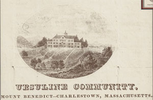
"...Within a year or two the "high fielde " of the original settlers, the "ploughed hill " of the Revolution, better known in our day as " Nunnery" or " Convent Hill" or " Mount Benedict," will be a memory only...." - Samuels, pg. 22, 1897 - Internet Archive |
| • |
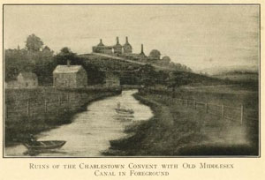
Ursuline Convent riots, "...The ruins of the convent remained in place for many years afterward, presenting a stark contrast to the nearby Bunker Hill Monument, completed in 1843. The property was eventually turned over to the Diocese of Boston, which sold it in 1875. Between then and the 1890s, Ploughed Hill was leveled, used to fill the nearby Middlesex Canal and marshlands along the Mystic River, and its site has since been built over with housing..." - Wikipedia |
| • |
"...Mount Benedict was under cultivation, and was termed 'Ploughed Hill.' It was said to have been so named because it had been customary to plough it in a circle around the hill, turning the furrows always down the slope ..." - Drake, pg. 310, 1880 - Internet Archive |
| • |
Mount Benedict - USGS Geographic Names Information System
Variant names: Convent Hill, Ploughed Hill |
|
| Powder House Hill |
| • |
USGS identified - MassMapper MassGIS |
| • |
Google Maps | Google Earth - Google |
| • |
"...In this way it occurred that the powder of several towns was stored in the powder house on Quarry Hill; fearing for its safety, in the summer of
1774, some of the towns began removing it...." - Samuels, pg. 45, 1897 - Internet Archive |
| • |
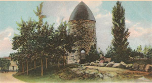
"...Quarry Hill is the site of the Old Powder House..." - Haley, pg. 17, 1903 - Internet Archive |
| • |
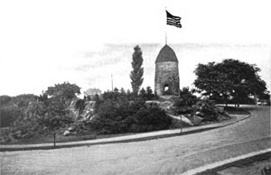
"...In May, 1892, the city council voted to accept the gift of 68,357 feet of land, including the site of the Powder House, tendered by the heirs of Nathan Tufts...The grounds were artistically laid out...and a beautiful park on ground of great historic interest was thrown open to the public. It is called the Nathan Tufts Park, as provided in the deed of gift...." - Samuels, pg. 158, 1897 - Internet Archive |
| • |
"...In this way it occurred that the powder of several towns was stored in the powder house on Quarry Hill; fearing for its safety, in the summer of
1774, some of the towns began removing it...." - Samuels, pg. 45, 1897 - Internet Archive |
| • |
"...Quarry Hill, smooth and polished, with little left of its antique charm, yet remains crowned by its old tower, which, though architecturally modernized with cut stone archway and window, is still a historic inspiration...." - Samuels, pg. 22, 1897 - Internet Archive |
| • |
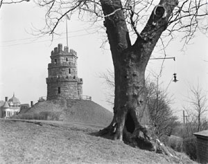
Powder House Windmill,"...The Powder House was originally constructed as a windmill by Jean Mailet (John Mallet) around 1704. The structure was sold to the Province of Massachusetts in 1747 for use as a powder house..." - Massachusetts Historical Commission Information System (MACRIS) |
| • |
Nathan Tufts Park,"...The Powder House sits on the edge of the old "Two Penny Brook Quarry" and was,
built of stone quarried there..." - Massachusetts Historical Commission Information System (MACRIS) |
| • |
Powder House Hill - USGS Geographic Names Information System |
|
| Prospect Hill |
| • |
USGS identified - MassMapper MassGIS |
| • |
Google Maps | Google Earth - Google |
| • |
"...Prospect Hill, on the east of Walnut Street, has been cut down to fill Miller's River. The city has taken the land for a public park, and
on the summit is being erected a lofty tower, which shall be a memorial of the historic events connected with the hill. ....", Haley, pg. 17, 1903 - Internet Archive |
| • |
"...The historic heights of Prospect Hill, the Mount Pisgah of the Revolution, have long since gone to bury the less historic shores of Miller's River...." - Samuels, pg. 22, 1897 - Internet Archive |
| • |
The History of Prospect Hill where the first American flag ever flew, "...Before the American Revolution made it famous, Prospect Hill was part of a dairy farm on the quiet, rural outskirts of Boston. Early on it was called Strawberry Hill and Wildredge's Hill, and in the 17th century was part of the estate of John Woolrych..." - Mudder Media |
| • |
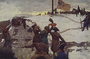
The First National Flag, "..Prospect Hill (known also as Mount Pisgah) was the strongest fortification of the American army during the siege of Boston, and it was here that the Union flag was unflurled for the first time January 1, 1776, the day on which the new Continental army was organized...", Harper's Weekly, vol. 42, pg. 6, 1898, Clyde O. DeLand - HathiTrust |
| • |
Original English inhabitants and early settlers in Somerville, "...There was no such person as Wildridge known to be in this vicinity, and the word may have been a corruption of Woolrych, after John Woolrych, of Strawberry Hill, and it may be that Wildridge's Hill and Strawberry Hill were identical...", Aaron Sargent, Somerville Historical Society, 1908 - Persus Digital Library |
| • |
"...Mr. John Woolwich, 'Indian trader,' lived a mile and a half without the neck, on the Cambridge Road, near Strawberry Hill, as early as 1630 ..." - Drake, pg. 310, 1880 - Internet Archive |
| • |
Prospect Hill - USGS Geographic Names Information System |
|
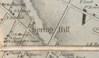
| Spring Hill |
| • |
USGS identified - MassMapper MassGIS |
| • |
Google Maps | Google Earth - Google |
| • |
Spring Hill Historic District,"...At one hundred and thirty-seven feet above sea level, Spring Hill reportedly derives its name from a spring which was located along the glacial drumlin or hill which runs between Lowell and Cedar Streets in the vicinity of Summer Street. As part of the 17th century Stinted Common, the area provided excellent farmsites for
Charlestown residents in the 18th and early-19th centuries. Farming, particularly the raising of dairy cattle and hay, was carried on until the Civil War. Market gardening, including the raising of fruit , could be found on Spring Hill until about 1890..." - Massachusetts Historical Commission Information System (MACRIS) |
| • |
"...Willis' Creek (the Miller's River of later times) took its rise at the base of Spring Hill, and flowed with pure and pellucid stream through the meadows to
the Charles River ..." - Drake, pg. 310, 1880 - Internet Archive |
| • |
Spring Hill, "...Spring Hill is the name of a ridge in the central part of the city of Somerville, Massachusetts, and the residential neighborhood that sits atop it...
Spring Hill was first developed in 1843 by George O. Brastow, an influential businessman who later became the first mayor of Somerville. He lotted one of Somerville's first residential subdivisions on the hill's south side between Central and Belmont Streets....." - Wikipedia |
| • |
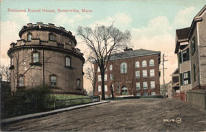
Round House, "...The Round House is a cylindrical, wood-frame residential building at 36 Atherton Street in the Spring Hill neighborhood of Somerville, Massachusetts, United States. It was built in 1856 by hardware manufacturer Enoch Robinson...." - Wikipedia |
| • |
Enoch Robinson House, The Round House - Massachusetts Historical Commission Information System (MACRIS) |
| • |
Spring Hill - USGS Geographic Names Information System |
|
| Strawberry Hill |
| • |
Google Maps | Google Earth - Google |
| • |
"...Strawberry Hill is mentioned once in the old records. It is supposed to be the high land near Kent Street. Professor Charles Eliot Norton's grove, just over the Cambridge line, is a part of it, and the part in Somerville was cut away in the construction of Beacon Street....", Haley, pg. 17, 1903 - Internet Archive |
| • |
"...Strawberry Hill, where is and where was it? Possibly and probably, if old records are correct, in which there is but one mention of it, east of
Beacon Street and north of Washington Street, a part of it still remaining on the Norton's Grove estate in Cambridge..." - Samuels, pg. 22, 1897 - Internet Archive |
| • |
"...Mr. John Woolwich, 'Indian trader,' lived a mile and a half without the neck, on the Cambridge Eoad, near Strawberry Hill, as early as 1630 ..." - Drake, pg. 310, 1880 - Internet Archive |
|
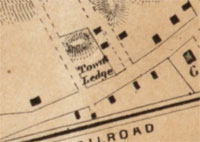
| Taylors Ledge |
|
| Ten Hills |
| • |
Google Maps | Google Earth - Google |
| • |
Ten Hills, "...Ten Hills is named after Ten Hills Farm, owned by Massachusetts' first governor, John Winthrop. This estate of 600 acres was granted to Governor Winthrop by the Massachusetts Bay Colony on September 6, 1631...." - Wikipedia |
| • |
Manuscript map of the Ten Hills (Medford, Mass.), October 1637:"...The first governor of Massachusetts, John Winthrop, owned property along the Mystic River. He called his estate Ten Hills..." - Massachusetts Historical Society |
| • |
Ten Hills Farm, with Anecdotes and Reminiscences, "...he called ‘The Ten Hills Farm,’ from the fact that it contained ten hillocks. Probably the original farm contained about seven hundred and fiftyfive acres, or a goodly portion of what is now the city of Somerville and the city of Medford....", Medford Historical Society Papers, Vol. 1 - Persus Digital Library |
| • |
Ten Hils (Populated place) - USGS Geographic Names Information System |
|
| Town Ledge |
|
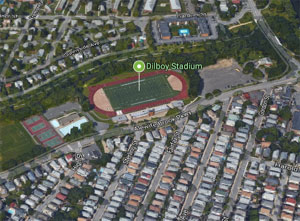
| Wild Cat Hill |
| • |
Google Maps | Google Earth - Google |
| • |
"...Wild Cat Hill was on the border of Alewife Brook. It is easy to divine the origin of this name...", Haley, pg. 17 - Internet Archive |
| • |
"...Wild Cat Hill, on the borders of Alewife Brook, from the remotest day until recently, has remained to thrill the mind with the possible cause for its name; but now it is degraded to a city gravel-bank, and will soon be gone...."- Samuels, pg. 22, 1897 - Internet Archive |
| • |
"...About $1,500 has been spent during the year in laying out and grading the proposed new athletic field, formerly known as ''Wild Cat Hill gravel pit'; an area of about three and one-half acres being practically ready for use...."- Annual report of the city of Somerville, 1908, pg. 301 - Internet Archive |
| • |
"...Dilboy Field (formerly Somerville Field) at Alewife Brook...."- Annual report of the city of Somerville, 1922, pg. 161 - Internet Archive |
|
| Winter Hill |
| • |
USGS identified - MassMapper MassGIS |
| • |
Google Maps | Google Earth - Google |
| • |
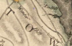
"...Winter Hill, the summit of which is on Broadway, near Central Street, has changed very little in shape and height. The origin of the name is unknown...", Haley, pg. 17, 1903 - Internet Archive |
| • |
"...Winter Hill, strange to say, so far as is known, has suffered no change since 'long ago,' either in height, contour or name; like Winter Brook, the origin of its name is in obscurity; whether named for a person, or a season, is an enigma. ....", Samuels, pg. 22, 1897 - Internet Archive |
| • |
"...Broadway, the heart of Winter Hill, was established in the 1630’s as Winter Hill Road...Winter Hill is actually one of the first named neighborhoods in Somerville. When Somerville was part of Charlestown, it was primarily referred to as Beyond the Neck. However, the name Winter Hill, referring to the land form, appears in 18th century maps and land records...", Winter Hill Neighborhood Plan, pg. 4, Somerville by Design, 2016 - City of Somerville |
| • |
Winter Hill - USGS Geographic Names Information System |
|
|
|
 |
|
 |
|
 |
|
 |
|
 |
|
 |
|
 |
|
 |
|
| Adams Ledge |
 |
|
| Central Hill |
 |
|
 |
|
| Clarendon Hill |
 |
|
| Cobble Hill |
 |
|
 |
|
| Mount Benedict |
 |
|
 |
|
| Powder House Hill |
 |
|
 |
|
| Prospect Hill |
 |
|
 |
|
 |
|
| Spring Hill |
 |
|
 |
|
| Ten Hills |
 |
|
| Town Ledge |
 |
|
| Wild Cat Hill |
 |
|
| Winter Hill |
 |
|
|
|
| More about Somerville's USGS-listed hills |
|
In 1912 the Somerville Board of Trade proudly titled a promotional book, “Somerville, Mass: The Beautiful City of Seven Hills.”1 Why was the number seven important? In 1908 Somerville mayor Charles A. Grimmons clarified the reason in a toast he gave at the 10th anniversary of the Somerville Historical Society, “Somerville, Like Rome, Sits On Her Seven hills, Each Crowned With An Historic Halo.”2 Comparing your city to Rome has been a popular way for officials of hilly cities around the world to show civic pride and champion their communities’ importance. Jump forward in time to 2004 and newly elected Somerville mayor Joseph Curtatone in his inaugural speech, used the line, “like Rome, we have seven hills, so we can dream even bigger dreams.”3 Who was the first to use “seven hills” to describe Somerville? One of the earliest uses was by Eliza A. (Monroe) Bacon-Lathrop (1816-1900). In 1857 she wrote an article in the Universalist journal, “The Ladies' Repository” titled “Prospect Hill.”4 In it is the line, “…the beauty of Somerville is its hills. Like Rome it sits proudly upon seven; not old in song and story, but rich with their yearly miracle of soft, green carpets, upon which sit the pretty houses of country loving people of all trades and professions from the distant city.” Clearly written at a time when Somerville was still a rural town (it wouldn’t become city until 1872), and Boston was considered a long way away. Mrs. Bacon, as she was known, became editor of the publication when her first husband died. Her second marriage was to another Universalist minister. |
|
While the identity of the seven hills of ancient Rome has been generally been agreed upon, the list of the seven in Somerville is not so settled. Civic and business leaders enjoy using the expression, but don’t typically take the time to list the hills. In 1872 Charles D. Elliot (1837-1908) became Somerville’s first city engineer.5 A civil engineer by training, he was also a member of Somerville Historical Society, and in 1896 wrote a history of Somerville in which he used the phrase, “…In their midst is Somerville ‘on her seven hills’.” He should know his hills, but instead took a pass on providing a definitive list identifying nine hills, possibly realizing there were issues trying to settle on seven. Eliza Bacon in her 1857 article identified the seven hills: Central Hill, Hospital Hill, Mount Benedict, Prospect Hill, Spring Hill, Walnut Hill, and Winter Hill. And the USGS identifies seven hills in Somerville. Most match, but not all. The USGS list is: Central Hall (125 ft.), Clarendon Hill (82 ft.), Mount Benedict (59 ft.), Powder House Hill (52 ft.), Prospect Hill (95 ft.), Spring Hill (131 ft.), and Winter Hill (121 ft.). The naming of hills in Somerville occurred in three time periods. First are hills named during the early settlement of the area. Second are hills that played in role in the Revolutionary war. And third are hills that were named, or changed their names, as Somerville grew as a city. |
|
Winter Hill appears of everyone’s list of the seven hills, including the USGS’, and it likely was the first hill to be named in Somerville. Before any bridges were built connecting Charlestown to Boston or Chelsea there were two roads travelers could take after leaving the Charlestown peninsula. Once “over the neck”, travelers could turn west and take road the led to Cambridge. Or, if traveling north, they could take the road that led to both Cradock’s ford (later bridge) in Medford, and to Menotomy (today’s Arlington). The road north was called Winter Hill Road as early as 1637 in Richard Frothingham’s 1845 book, “The History of Charlestown.” Oddly, how Winter Hill got its name is a question the authors of three histories of Somerville all wrote they couldn’t answer: Elliot (1896), “no man knows how”; Samuels (1897) “the origin of its name is in obscurity; whether named for a person, or a season, is an enigma”; and Haley (1903), “The origin of the name is unknown.” A Winter Hill neighborhood plan produced by the city of Somerville in 2016 didn’t add much clarity when it said, “the name Winter Hill, referring to the land form, appears in 18th century maps and land records.” The early Boston settlers almost exclusively named hills - and for that matter towns, rivers, and everything else – after places in England. Roxbury, or “Rocksberry”, for the stones and rock outcroppings, was about as original as they got. There is a Winter Hill in northwest England. A long low hill, possibly similar to the long low drumlin John G. Hales labeled Winter Hill in his 1820 map, “Map of Boston and its Vicinity from Actual Survey.” Later maps show Winter Hill as more a single prominence. |
|
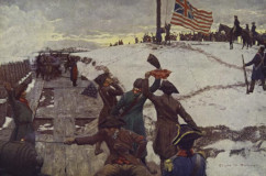
The most famous hill in Somerville would be Prospect Hill. It’s on everyone’s list, including the USGS. The name is not unique in the Boston Basin, Waltham and Lynn both have a Prospect Hill. Newton had one but changed its name to Waban Hill. Massachusetts in total has over 30 Prospect Hills. The name is from the Latin prospectus, "distant view, look out", though the hill is not the tallest in Somerville. It’s fame, and likely why many other hills are named after it, recall the events that took place on the hill during the Revolutionary war. Following the Battle of Bunker Hill on June 17, 1775, Continental troops fell back to positions they could fortify including Prospect Hill. The hill had been called Wildridges Hill, likely a misspelling of name John Woolrych. He was once of the first settlers in the area living in a house at the hill in 1635. And it was also known as Strawberry Hill. It’s not clear if the hill was called Prospect Hill before it gained its importance as a good location to watch what the British were doing in Boston. The hill picked up one other name during the conflict, Mount Pisgah. This by the British troops to mock the Continental soldiers that they, like Moses, would never reach the promised land, Boston. While being an important part of the Continental during the conflict, its unlikely Prospect Hill would not have become famous if not for an event that took place January 1, 1776. On that day George Washington as the new general of army was on the hill and ordered a new flag be raised for the first time, the Grand Union Flag with it’s Union Jack and thirteen red and white stripes. It was an important rallying point for the army and is commemorated in plaques, paintings, speeches and annual reenactments. One point of discussion is the question of what was on the flag that was raised. In 2006 Peter Ansoff created a stir when at a North American Vexillological Association (the study of flags) meeting when he presented a paper arguing that the actual flag that was raised on that day in 1776 was a regular British Union Jack.6 The arguments are academic and interesting. One fact that stands out is that the British in Boston upon first seeing the flag thought the Continental army was surrendering. A confusion that could be explained by them seeing a Union Jack on Prospect Hill. |
| Nothing appears to be complicated in the naming of USGS-listed Spring Hill. A spring from its base fed Millers River, earlier known as Willis Creek. In the mid-1800s the river became a dumping place for industrial wastes. The smell and health problems related to this use resulted in the passage of the Massachusetts Public Waterfront Act of 1866. Known as Chapter 91, it represented some of the first public health based anti-pollution environmental laws in the country.7 The top of Prospect Hill was cut down to fill most of Millers River. Recently the small remaining section of the river underneath the Leonard Zakim Bridge has been made into the Millers River Littoral Way Park. |
|
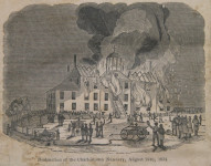
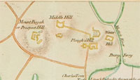
Though little of it still remains, USGS-listed Mount Benedict is widely agreed on as one of Somerville’s seven hills. Also known as Convent Hill for an Ursuline Convent that was located at its summit, the hill recalls a sinister event that happened there in 1834. Fed by rumors and encouraged by anti-Catholic sermons from ministers like Lyman Beecher (1775–1863), a Protestant mob burned down the Convent and then returned the next day and destroyed the gardens and orchards, set bonfires, and pulled down fences.8 The ruins of the convent remained in place for many years afterward. Much of the hill, which had also been called Ploughed Hill in colonial times, was leveled. |
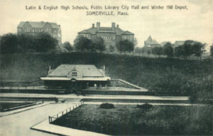
| Central Hill in Somerville is home to City Hall, a high school, public library, memorials and plaques honoring veterans, a playground, and like Prospect Hill played an important part in the Revolutionary war. It’s on Mrs. Bacon’s list from 1857, but not USGS list. They have a record for the Central Hill Playground, but oddly the closest match is a record for a summit called Central Hall. The coordinates put its location west of the historic Central Hill, closer to Spring Hill. Like a number of other hills on the northern border of the Boston Basin, the USGS citation only lists Alden T. Vaughan and his 1965 book, New England Frontier: Puritans and Indians 1620-1675. There is no mention of Central Hall in the book, and there is no mention of a geological survey confirming the name or location. During the Revolutionary war, the hill sometimes is called Middle Hill for its location between Winter Hill and Prospect Hill. |
|
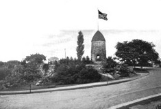
A hill with a rich history included by USGS, but not by Mrs. Bacon, is Powder House Hill. If Rome was famous for eight hills and not seven, likely she would have included Powder House Hill in her list. A large round stone structure on top of the hill was constructed by the John Mallet family in 1704 for use as a windmill. French Huguenot exiles, they had quarried the stone from the hill that has also been called Quarry Hill.9 The structure was converted to a powder house in 1747 and by 1774 contained the largest supply of gunpowder in Massachusetts. An event that could be argued was more important than George Washington raising a flag on Prospect Hill, took place there of September 1, 1774. On that day the British authorities in a surprise move sent 250 soldiers to the powder house and removed all the gunpowder, bringing it back to Castle Island (then called Castle William) for safe keeping. Despite rumors that spread to the contrary, no one was injured or killed. The raid did however set off was has been called the Powder Alarm.10 The story spread quickly throughout the colony with many colonists taking up arms. The important impact of the raid was a shift in public opinion among even colonists who earlier had shown little interest in calls for a revolution. They would be ready when the British attempted another raid of military supplies in Concord, Mass. on April 17, 1775. |
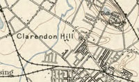
| Mrs. Bacon would have known USGS-listed Clarendon Hill only a region of minor hills used as quarries for sand and gravel. The use of an old English old name for the hill was likely selected by a land developer anxious to make his new subdivision sound respectable. The name of Somerville for the town itself was likely a similar way. It is recorded that Walford was the initial name put forward for the new town in 1842. Thomas Walford, a blacksmith, with his family were the first settlers on the Charlestown peninsula, then called Mishawum by the Native Americans, as early as 1624. On the south slope of what would be Breed’s Hill they built a palisaded and thatch house. There they fished, cultivated land, and began trading with the Native Americans. Their seclusion would end in 1629 when a group of men appeared looking to prepare a location for the expected arrival the following year of the main party of Puritans lead by John Winthrop. With no clear title to their land, Episcopalian leanings, dealings with the native Americans suspicious to the Puritans, and used to having their independence, the Walfords were rejected by the new Puritan neighbors. Charged with “contempt of authority and confronting officers” and not conforming to “sabbath observances“, they were banished in 1631 and settled on the Piscataqua River on the boundary between Maine and New Hampshire. It’s likely the naming committee did not want to explain why Walford would be a good name for the town. On the other Somerville, the surname of Scottish royal family, sounded good, and at the time there were no other towns or cities named Somerville. |
| From Mrs. Bacon’s point of view the USGS missed two hills. She included Walnut Hill, also known as College Hill for the Tufts University located there, in her list of seven. Technically the summit of the hill is in Medford, not Somerville. Both Medford and Somerville claim Tufts family members as native sons, and numerous Tufts descendants have lived in Medford, Malden and Somerville (then Charlestown). Peter Tufts (1617-1700) was the first, immigrating in 1637. Charles Tufts (1781–1876) donated land in Medford for Tufts University. Earlier, Nathan Tufts (1724-1771) donated land for Powder House Park. |
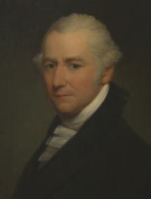
|
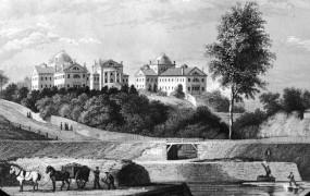
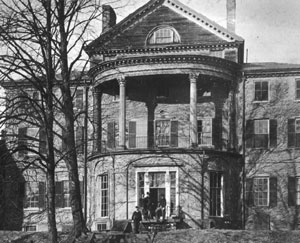
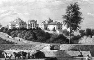
The last of Mrs. Bacon’s seven hills she called Hospital Hill. It was also known as Asylum Hill for the McLean Asylum for the Insane located there. Opened in 1818, it was only the fourth special institution for the treatment of the mentally ill in America. The Massachusetts General Hospital, then only recently chartered, had purchased the house and grounds on what then called Pleasant Hill. It was the former estate of the merchant Joseph Barrell (1739-1804).11 Born in Boston, he was the sixth of eleven sons of John Barrell (1707-1781), a merchant and shipbuilder. He was the great-grandson of the immigrant John Barrell (1618-1659), who appropriately was a cooper, a maker of barrels. Barrell had hired a young Charles Bulfinch (1763-1844) to design the mansion in 1792, and then later the hospital would hire Bulfinch again this time to design additional wings for patients. Bulfinch is considered by many to be the first native-born American architect. He is known for buildings such as the Massachusetts State House, the initial domed center building of the U.S. Capital in Washington, D.C., and other private residences, churches, and public buildings. Barrell’s accomplishments, on the other hand, have been largely ignored. This despite Barrell playing a major role in historical events were far more important to the country than the choice of an architectural style for a building. It was Barrell who gave Charles Bulfinch his first job, and at it was Barrell’s collection of books that helped cultivate the young college graduate’s interest in architecture. |
|
Joseph Barrell had followed in his father’s footsteps to become a merchant, and additionally a grocer opening a store in Boston. The Revolutionary war would split up the Barrell family. Joseph’s father had a close relationship with the British army, earlier having the contract to supply British troops at Annapolis Royal in Nova Scotia. He and two of his sons remained loyal and would flee Boston ending up in England. Joseph was a patriot, his name is on a list of three hundred and fifty-five Sons of Liberty who dined at the Liberty Tree in August of 1769, along with Samuel and John Adams, and Paul Revere. For merchants, blockades and shortages during the Revolutionary war presented significant challenges, but also great opportunities for those willing to take a risk. Joseph was one of about 1,700 men who received Letters of Marque from the Continental Congress. This allowed him to sponsor private ships that could challenge any likely enemy vessel that crossed its path during a commercial voyage. The proceeds from the sale of the prize and its cargo was shared among the owners and crew of the privateer according to a pre-arranged contract. For the sailors of the privateers, the potential reward was far greater than any they could get from other work. But there was also the risk of death or capture and imprisonment in one of notorious British prison ships. For the merchants, the risk was only financial, and the rewards were significant. Nearly 800 vessels were commissioned as privateers during the war, over 300 from Massachusetts. They are credited with capturing or destroying about 600 British ships. This in comparison to a total of 65 vessels that served in the Continental Navy with less than 10 at sea at any one time. |
| Privateering was very lucrative for Barrell, but it doesn’t explain how Barrell was able to buy over 200 acres of land overlooking Charles River in Charlestown, build what was called “the most elegant dwelling house ever yet built in New England”, and surround it with trees, lawns, terraces, gardens, fish ponds, dovecotes, poultry yard, stables, wine cellar, nursery for fruit trees, a large barn, and a boat-house, then name the estate, Pleasant Hill. He like others of the time was willing to take risks. What made him special was his ability to come up with innovative solutions that would benefit himself, and Boston and the country. |
| After the British evacuation from Boston in March of 1776 most of the military action during the Revolutionary war moved to the Mid-Atlantic and Southern states (though naval action just out of the harbor continued though out the war) Barrell, a member of the Sons of Liberty, had left Boston temporarily. When he returned, it was not an easy time to be a grocer. Sponsoring privateers was lucrative for him financially, but it did not provide the food stuffs for his business. The army needed to be supplied, blockades, complaints of price gouging, rampant inflation, and rapidly depreciation of the new currencies then being issued. Food riots broke out. Then in August of 1778 a French fleet arrived in Boston Harbor with 7,500 sailors and marines needed to be fed. And they were all Catholics. |
| France had officially recognized the United States in February of 1778. In July of that year a French fleet under the command of Charles d'Estaing arrived off the coast of Rhode Island in planned joint effort with Americans to capture Newport. Initially the operation went well with the British destroying some of their own ships. But following a delay in the arrival of Patriot troops and missed communications, the French withdrew troops that they all already landed. This after they received news of an approaching British fleet. A violent storm forced the two fleets to separate, but not before severely damaging many French ships. They withdrew to Boston for repairs. |
| The official reception by the likes of John Hancock, John and Samuel Adams, and Joseph Warren was warm. They knew, as George Washington did, that the country needed the help of France if they hoped to win the war against England. The general public in Boston were not so pleased to see the French. Memories of losses suffered during the French and Indian war were still fresh, and in Protestant Boston, anti-Catholic sentiment was the norm. Couple all of this with reports from the Patriot army that the failure to capture Newport from the British was the fault of the French, and it remarkable that France’s cooperation in the war didn’t come to a crashing end in Boston that fall. It was close. In September there was a riot at a bakery the French had established near the harbor, and in the altercation two French officers were injured, with one later dying. Boston’s Patriot leaders knew that had a serious. Cooler heads on both sides prevailed, plus official pronouncements of shock, votes to erect a monument, apologizes, formal dinners, and what were likely false accusations of British loyalists starting the riot. But there were still 7,500 French sailors and marines that needed be to fed. Joseph Barrell had a solution. |
| The typical grocer at the time typically only sold dry goods such as spices, peppers, sugar, teas and coffee. Meat, wheat, butter, eggs, cheese, milk, fruits, vegetables, and other produce was sold at markets by the individual producers. Barrell’s innovation was to consolidate and regulate the purchasing of food across the supply base that would eventually lead to more efficient local exchanges. Then Barrell alone would sell to the French fleet all the food they needed, paid in French gold coins, with a 5% commission. France would continue to support the Patriots. The fleet would leave in the fall, but a French military and naval presence continued in and around Boston until the end of the war. It is not recorded, but it’s likely Barrell had some role in supplying it. |
| It was during this time that Barrell hired the young Charles Bulfinch to work in his counting office and help with supplying the French fleet. Barrell was friends with his father, Thomas Bulfinch (1728-1802), a prominent Boston doctor who had married Susan Apthorp (1734-1814). She the daughter of Charles Apthorp (1698–1758), a merchant known as the richest man in Boston. Charles Bulfinch would marry his first cousin Hannah Apthorp (1767-1851) in 1788. The Bulfinch’s could easy afford to send their son a two-year Grand Tour of Europe, which he took in 1785 after graduating with a master’s degree from Harvard in 1784. |
| At the end of the war Barrell was a wealthy man looking for new opportunities.12 Restrictions imposed by the British were now lifted and Americans could trade anywhere in the world. The greatest opportunities were in China which had recently opened the port of Guangzhou (then Canton) for trade. Abundant supplies of tea, fine porcelain and silk were available if a merchant had what Chinese traders were looking for. The ship Empress of China was the first American merchant vessel to reach China in 1784. Sailing out of New York, the venture was jointly financed by investors in New York and Philadelphia lead by Robert Morris (1734-1806). He one of the key financiers of the American Revolution, Head of the Navy, and Superindent of Finance for the country. Trading ginseng and specie (currency in coin), the venture produced a modest profit. Numerous ships headed toward China including the first one from New England, Grand Turk, financed by Salem’s Elias H. Derby (1739-1799). It returned in 1787. |
|
Barrell was not sitting on the sidelines. He tested the market by including a shipment of ginseng in the cargo on the Empress of China. He along with others recognized the problem, there was a limited market in China for New England’s abundant supplies of cod, whale oil, turpentine, or lumber. A possible solution presented itself in 1783 with the publication of a book by Connecticut-born James Ledyard (1751-1789). In 1776 he had joined the third voyage of the renowned English explorer James Cook as a British marine. When he returned he wrote a book, A Journal of Captain Cook's Last Voyage to the Pacific Ocean. In it he noted on a stopover to Macau, that sea otter belts purchased cheaply from Native Americans in the Pacific Northwest were highly prized by the Chinese and commanded a high price. Ledyard approached the group financing of the Empress of China voyage and a plan was drawn up for a second ship to collect the otter pelts in the Pacific Northwest, then meet the Empress of China in the Falkland Islands. But finances for the second ship fell through and the plan for a second ship was scrapped. This after a group of Boston merchants backed out. |
| Was Barrell part of that group that backed out of financing the second ship? It’s not known. He too had read Ledyard’s account, but the risks of a voyage to the Pacific Northwest were almost uncalculatable. Lewis and Clark wouldn’t’ reach the Pacific Ocean until 1805. The era of hunting whales in the Pacific wouldn’t start until 1789, and then only in the southern Pacific. The Spanish had explored the coast, but they were secretive, as were the English pirates who chased them. |
|
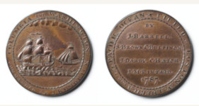
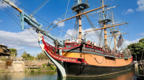
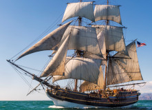
It would be Barrell who would be the driving force and lead investor of the voyage that would establish an American presence in the Pacific and position the new country as a player in the global market. Two ships, the Columbia Rediviva and the Lady Washington, left Boston on September 30, 1787 on a voyage to the Pacific Northwest by way of South America’s Cape Horn. Arriving the following year, they traded for otter pelts. The Columbia then headed west across the Pacific first stopping in Hawaii, considered by most to be the first American ship to stop there. On November 17, 1789 the Columbia arrived Canton establishing a completely new trade route, lead by Americans. The Columbia would return to Boston on August 9, 1790 traveling by way of the Cape of Good Hope in Africa making it the first American ship to circumnavigate the world. |
|
Complications dealing with the complexities of trading the otter pelts in China made the voyage unprofitable, but six weeks later the Columbia left for second voyage. When it returned in 1793, the cargo of tea, porcelain, and sugar sold for a significant profit. On the second voyage, ship captain Robert Gray (1755-1806) was the first to successfully navigate the treacherous entrance to largest river in the Pacific Northwest, which he then named after his ship, the Columbia River. British Columbia in Canada gets its name from the ship. In modern times the Columbia has been used for the Command Module on the Apollo 11 mission that landed the first people on the moon, and on the ill-fated Columbia Space Shuttle. There is an accurate replica of the Columbia in Disneyland, and of Lady Washington in Grays Harbor, Washington, named for Captain Gray. There used to be a Barrells Sound, but it’s located in what would become Canada and its name was changed. |
|
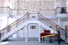
With the profits from the second voyage Barrell had the money to finish his estate on Pleasant Hill. He had hired the young Charles Bulfinch, now back from his Grand Tour of Europe, to design the house. Bulfinch had been a silent investor in the voyage, though it is thought that it was his father who invested the money for him. The two would also work together on Bulfinch’s innovative curved Franklin Place three-story townhouse building in Boston, also known as the Tontine Crescent. The land where it was built was marshland owned by Barrell. A curve on present-day Franklin marks its location. Unfortunately, the bucolic setting that Barrell and then the Hospital had chosen being conveniently close to Boston was changing. When the hospital sold the property in 1895, it was encircled by a network of railroad lines. The hospital moved to Belmont. The buildings were torn down, and the hill leveled to fill nearby Millers Creek. One interesting architectural detail that remains is a unique double flying staircase Bulfinch designed now preserved at the Somerville Museum. Barrell was an ardent Federalist and an early investor in the Massachusetts branch of the new Bank of United States. |
| If USGS were to identify the hill as an historical summit, like Fort Hill in Boston, they might use the name Cobble Hill instead of Hospital Hill or Pleasant Hill. It was called Cobble Hill when Israel Putnam (1718-1790) built fortifications there during the Revolutionary War. The hill likely named for its rounded shape like a cobble. An alternative explanation given by Bob (Monty) Doherty who suggests that the hill was named for flat-bottom boats common in England called “cobles.” The hill was nearly surrounded by water at high tide. Earlier the hill had been called Millers Hill for the same Richard Miller that the river was named after. He lived there in 1637. An even earlier settler in the area was Edward Gibbons. He was in Plymouth in 1624, then in Charlestown in 1628. Millers River was first called Gibbons River, there is a record of an area called Gibbons field, possibly the hill was called by his name. |
|
|
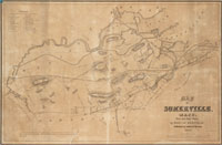
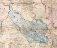
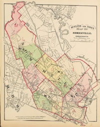
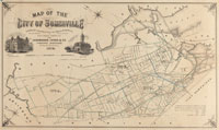
| Somerville Maps |
| • |
Somerville - Google Maps, Terrain |
| • |
Somerville - MassMapper OLIVER |
| • |
Somerville - USGS - The National Map |
| • |
Boston North Quadrangle - 2018 (60 MB PDF) - USGS Topo Download |
| • |
Boston South Quadrangle - 2018 (60 MB PDF) - USGS Topo Download |
| • |
Map of Somerville, Mass., Martin Draper, 1852 - Norman B. Leventhal Map Center, Boston Public Library |
| • |
Map of the City of Somerville, George A. Kimball, 1874 - Norman B. Leventhal Map Center, Boston Public Library |
| • |
Atlas of the City of Somerville, Massachusetts, G.M. Hopkins & Co., 1874 - State Library of Massachusetts |
| • |
Map of the cities of Boston, Cambridge, Somerville and Chelsea, and the town of Brookline with parts of Newton, Malden and Everett, G.M. Hopkins & Co., 1874 - Norman B. Leventhal Map Center, Boston Public Library |
| • |
Atlas of the Boundaries of the City of Somerville, Middlesex County, 1874 - State Library of Massachusetts |
| • |
Map of Somerville, Mass., 1884 - Norman B. Leventhal Map Center, Boston Public Library |
| • |
Atlas of the City of Somerville, Massachusetts, G.W. Bromley & Co., 1895 - State Library of Massachusetts |
| • |
Somerville Maps: 12, 13, 14, 15, 16, 17, Atlas of Middlesex County, Volume 1, George W. Stadly & Co., 1900 - State Library of Massachusetts |
| • |
Map of Middlesex County, Mass., Henry F. Walling, 1856 - Library of Congress |
|
|
| Somerville Sources |
| • |
Somerville's History, Charles D. Elliot, 1896 - Internet Archive / HathiTrust |
| • |
Somerville, Past and Present, Edward A. Samuels, 1897 - Internet Archive |
| • |
The Story of Somerville, Mary A. Haley, 1903 - Internet Archive |
| • |
Haskell's Historical Guide Book of Somerville, Massachusetts (PDF), Albert L. Haskell, 1905 - City of Somerville |
| • |
Historic Leaves, Somerville Historical Society Vol. 1-2, Vol. 3-5, Vol. 6-8, 1902-1910 - HathiTrust |
| • |
Somerville, Mass., The Beautiful City of Seven Hills, its History and Opportunities, Somerville Board of Trade, 1912 - Internet Archive |
| • |
Somerville, History of Middlesex County, Massachusetts: Containing Carefully Prepared Histories of Every City and Town in the County, Samuel A. Drake, 1880, Vol. 2 - Internet Archive |
| • |
The History of Charlestown, Massachusetts, Richard Frothingham, Jr., 1845 - Internet Archive |
| • |
The Genealogies and Estates of Charlestown, Vol. 1 (A-J), Vol. 2 (K-Z), Thomas B. Wyman, 1879 - Internet Archive |
| • |
Somerville, A Gazetteer of the State of Massachusetts, pg. 271, John Hayward, 1847 - HathiTrust |
| • |
Somerville, A Gazetteer of the State of Massachusetts, pg. 598, Elias Nason, 1890 - Internet Archive |
| • |
Somerville, Massachusetts: A Brief History, Dee Morris, Dora St. Martin, 2008 - Google ebook preview |
| • |
Somerville: Images of America, Anthony M. Sammarco, 1997 - Google ebook preview |
| • |
A Social History of Somerville, Massachusetts 1630-1842, Isobel M. Cheney, 1949 - Boston University Library |
| • |
Somerville, MHC Reconnaissance Survey Town Report (PDF), 1980 - Massachusetts Historical Commission |
| • |
Historic Somerville |
| • |
Somerville Open Space & Recreation Plan, 2016-2021 (PDF) - City of Somerville |
|
|
| Footnotes |
| 1 |
Somerville, Mass: The Beautiful City of Seven Hills, Somerville Board of Trade, 1912 - Google ebook |
| 2 |
Somerville, Like Rome, Sits On Her Seven hills, Each Crowned With An Historic Halo, Charles A. Grimmon, Historic Leaves, Somerville Historical Society, pg. 80, 1908- Internet Archive |
| 3 |
Mayor Curtatone’s Inaugural Speech, 2004 - JoeCurtatone.com |
| 4 |
Prospect Hill, Eliza A. Bacon, The Ladies' Repository, Vol. 28, pg.13, 1858 - HathiTrust |
| 5 |
Charles Darwin Elliot Diary and Surveyor Field Books, 1863-1864, UNC Libraries, Southern Historical Collection - University of North Carolina |
|
Charles D. Elliot, Member of the Boston Society of Civil Engineers, J. Albert Holmes, Historic Leaves, Vol. 8, 1910 - Persus Digital Library |
|
Charles Darwin Elliot, The New England Historical and Genealogical Register, Vol. 63, 1909 - Google ebook |
| 6 |
The Flag on Prospect Hill Peter Ansoff, Raven: A Journal of Vexillology, Vol. 13, 2006 - North American Vexillological Society |
| 7 |
Millers River, Mark Jaquith, Cambridge Community Television, 2008 - Cambridge Community Television |
|
Millers River - Only a Remnant Survives , 2011 - Massachusetts Oyster Project |
| 8 |
Boston Irish Long Remembered the 1834 Charlestown Convent Fire, Helen Breen, 2017 - Historic Ipswich |
|
The Burning of the Charlestown Ursuline Convent and School - Charlestown Historical Society |
| |
Fire & Roses: The Burning of the Charlestown Convent, 1834, Nancy L. Schultz, 2000 - Google ebook preview |
| |
Anti-Irish Know Nothing Mob Burns a Charlestown Convent in 1834 - New England Historical Society |
| 9 |
The old powder house, Medford Historical Society Papers, Volume 29, 1926 - Persus Digital Library |
|
The Mallet Family, Florence E. Carr, Historic Leaves, Vol. 2, pg. 10, 1904 - HathiTrust |
|
Old Powder House - Atlas Obscura |
| 10 |
Building to a Revolution: The Powder Alarm and Popular Mobilization of New England Countryside, 1774-1775, Patrick Johnston, Historical Journal of Massachusetts, Vol. 37, Spring 2009 - Westfield State College |
|
1774 - the Powder Alarm (Podcast), Mark Jessop, Chris Mooney, 2016 - History Podcasts |
|
Historic Powder Houses of New England: Arsenals of American Independence, Matthew E. Thomas, 2013 - Google ebook preview |
| 11 |
The Joseph Barrell Mansion on Cobble Hill - Historic Somerville |
|
Joseph Barrell’s Pleasant Hill, April Meeting, 1960 - Colonial Society of Massachusetts |
|
An Alphabetical List of the Sons of Liberty who din'd at Liberty Tree, Dorchester, William Palfrey, 1769 - Massachusetts Historical Society |
|
The Opportunist: Joseph Barrell, Hit and Run History, The Columbia Expedition - WGBH |
|
Why Did a Boston Mob Kill a French Officer?, Christian M. McBurney, 2018 - Journal of the American Revolution |
|
The Life and Letters of Charles Bulfinch, Architect: With Other Family Papers, Ellen S. Bulfinch, 1896 - Google ebook preview |
|
Privateers in the American Revolution, John Frayler, Salem Maritime National Historic Site - National Park Service |
|
Privateers of the Revolution, Charles R. Lampson, 2011 - The Massachusetts Society Sons of the American Revolution |
|
The Unlikely Role of Patriot Pirates, Robert H. Patton, 2008 - U.S. News & World Reports |
| 12 |
Columbia at sea: America enters the Pacific, 1787-1793, Eric O. Oakley, 2017 - University of North Carolina, Greensboro |
|
A Journal of Captain Cook's Last Voyage to the Pacific Ocean, John Ledyard, 1783 - HathiTrust |
|
Voyages of the Columbia - Center for the Study of the Pacific Northwest |
|
Robert Gray, The American Discoverer of the Columbia, Agnes C. Laut, Vikings of the Pacific: The Adventures of the Explorers who Came from the West, Eastward, pg. 209, 1914 - Google ebook |
|
Columbia and Washington Medal, 1787 - Massachusetts Historical Society |
|
The Auction: The Columbia and Washington Medal, Hit and Run History, The Columbia Expedition - WGBH |
|
Sea Otter - The Oregon History Project |
|
Sandlewood trade - HawaiiHistory.org |
|
|