| Hills of Needham, Mass. |
| | Hills | More about Needham's USGS-listed hills | Maps | Sources | |
| Birds Pond |
| • |
USGS identified - Oliver MassGIS Online Mapping Tool |
| • |
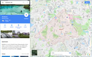
Google Maps location, 3D view (PC) - Google Maps |
| • |
John Bird House, "...In 1746-46 Deacon Jeremiah Woodcock (1675-1744) of Needham, and his sons Nathaniel (1707- ) and Michael Woodcock (1711- ) sold 215 of their 230-acre land holdings at what is now Bird's Hill, to Benjamin Bird Esq. of Dorchester...
...In 1755 John Bird married Mary Lyon of Needham and built a new house for his bride on the part of his estate that lay westward of Bird's Hill. ." - Massachusetts Historical Commission Information System (MACRIS) |
| • |
The John Bird House 1755, "...The Bird House was built in 1755 by John Bird. It was built on 216 acres which is now known as Bird Hill. John lived in the house with his wife Mary Lyon....", Old Houses of Needham - John Eliot Elementary School, Needham, MA |
| • |
"...Bird's Hill takes its name from John Bird, a former owner, who was a soldier in the Revolution...", Clarke, pg. 136, 1912 - Internet Archive |
| • |
Water Storage, "...The Birds Hill Tank is also located at a high elevation area bounded by Hillcrest Road and Morningside Road. The tank was constructed in 1972 by the Fisher Tank Company and has a diameter of 100 feet and a height of 45 feet. The Birds Hill Tank has a capacity of 2.5 million gallons of water....", Water Distribution - Town of Needham |
| • |
Birds Pond - USGS Geographic Names Information System |
| • |
Birds Hill (Populated place) - USGS Geographic Names Information System |
|
|
|
|
|
| More about Needham's USGS-listed hills |
|
Needham has one USGS-listed hill that is included in the Boston Basin Hills survey area.
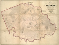
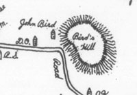
Oddly, the USGS classifies the feature Birds Pond as a Summit, and Birds Hill as a Populated Place. All historic USGS maps label the feature Birds Hill. It only becomes labeled Birds Pond in the 2015 USGS topographic map. The feature is shown and identified as Bird’s Hill in a map produced in 1829, and in a recreation of an historic 1775 map. The hill was named for John Bird (1729-1810), and the house he built for his bride Mary Lyon (1734-1782) in 1755 still stands on the west side of the hill.1 Needham had incorporated as a town in 1711 after splitting off from Dedham. Both named after towns in England. Wellesley spilt off from Needham in 1810. The land where John Bird built his home had been bought by his father Benjamin Bird (1686-1757). He was a descendant of Thomas Bird (c. 1613-1667), a tanner, born in England. He settled in Dorchester and joined the church there in 1642. Benjamin was an important citizen in Dorchester, a Constable, Selectman, Assessor, Deputy to the General Court, and a prominent land owner. His purchase of land in 1746 in Needham, some distance from Dorchester, possibly coincides with his involvement in a religious controversy sometimes known as the Whitefield excitement.2 Benjamin was the lead supporter in Dorchester of the controversial religious evangelist George Whitefield (1714-1770). An actor by training, a graduate of Oxford College, Whitefield toured England and the American colonies preaching in the open attracting large crowds attacking the established church and its clergy. Benjamin was excommunicated from the church, and he never did move to his property in Needham, instead willing it to his children when he died. |
| The land with the hill that Benjamin Bird bought was owned by Jeremiah Woodcock (1675-1752). He was a descendant of John Woodcock (c. 1615-1701).3 An interesting historical character, there is no question Jeremiah was the ancestor of John, but there is debate if there was another John Woodcock in New England in the early and middle 1600s. A John Woodcock is listed as a 20-year-old sailing with the Joseph Hull Company in 1633 to New England. Hull would establish the town of Weymouth in 1635. Later in 1635 there is a record of a John Woodcock sailing up the Connecticut River scouting for William Pynchon a location for a settlement that would become Springfield. Pynchon had founded Roxbury in 1630, and was looking westward for better farm land, and more opportunities to trade with Native Americans for furs. The land, then known as Agawam, was well into unsettled territory, the wild west of the time. The initial success of the settlement was in large part due to Pynchon’s good relationship with the Native Americans. But further expansion of Europeans less-hospitable to Native Americans would sour relations, and Pynchon, also caught up in a religious controversy (his book, “The Meritorious Price of Our Redemption,” deemed blasphemous, was burned in Boston Common), returned to England in 1651. The John Woodcock in Springfield at that time was not a model Puritan. He is the records of the General Court in 1639 complaining about wages due, in 1640 its slander and two suits about pigs and hogs, in 1641 non-delivery of a gun, and in 1642 its slander again, this time of the Rev. George Moxon for “laughing in Sermon tyme.” Clearly not a traditional Puritan of the time. |
| The same, or possibly a different John Woodcock, in 1649, is married and living in Roxbury, starting a family. The same Roxbury founded by William Pynchon, and where he had been his neighbor. In 1647 Woodcock buys land in Rehoboth, Mass. He and his family are living in the area by 1654 because in that year Woodcock is convicted of kidnapping a Native American child for non-payment of a debt. In 1670 he has opened an inn in what would become North Attenborough, making him it’s first citizen. More than just an inn, the building was fortified and served as a secure garrison house, one of a number located on the old road from Boston, Mass. to Providence, R.I. This was a dangerous time for colonists in New England, and except for major settlements, no place was safe, especially Woodcock’s house in the then wilderness. Colonial expansion had strained relations with Native Americans to the breaking point, and what is sometimes called King Philip’s War breaks out in 1675. Old alliances collapse and fighting occurs throughout New England. Springfield, Mass, is burned to ground in 1675, Providence, R.I. in 1676, Plymouth Plantation is attacked. Woodcock’s garrison house becomes a safe haven and rallying point for Colonial troops traveling up and down the old Bay Road. Woodcock loses two sons in the fighting, one beheaded directly in front of his house. When the old house is torn down years later, many of the logs have bullets embedded in them. |
| John Daggett is his 1894 book, A Sketch of the History of Attleborough, gives a sober description of his life, “John Woodcock, Sen., died October 20, 1701, having arrived at a very advanced age in spite of the many attempts which had been made by the Indians to destroy him. It is said that after his death the scars of seven bullet holes were counted on his body. ... He was foremost in all enterprises the object of which was the destruction of the Indians. He was a very useful man as a pioneer in the dangers and hardships of a new settlement, being cunning in contrivance and bold and active in execution.” He sounds like the same man that sailed up the Connecticut river years earlier. |
|
|
| Needham Maps |
| • |
Needham - Google Maps, Terrain |
| • |
Needham - OLIVER MassGIS's Online Mapping Tool |
| • |
Needham - USGS - The National Map |
| • |
Newton 1944 Quadrangle - USGS Historical Topographic Map Explorer |
| • |
Newton Quadrangle - 2018 (PDF) - USGS Topo Download |
| • |
Map of Town of Needham, Mass., Amanda Kingdbury, 1852 - Norman B. Leventhal Map Center, Boston Public Library |
| • |
Map of Norfolk County, Massachusetts, Henry F. Walling, 1853 - Norman B. Leventhal Map Center, Boston Public Library |
| • |
Map of the Town of Needham, Massachusetts, Henry F. Walling, 1856 - Norman B. Leventhal Map Center, Boston Public Library |
| • |
Maps of Needham - Needham Public Schools |
|
|
| Needham Sources |
| • |
History of Needham, Mass., 1711-1911, George K. Clarke, 1912 - Internet Archive |
| • |
Needham, History of Norfolk County, Massachusetts, 1622-1918, Louis A. Cook, Vol. 1, 1918 - Internet Archive |
| • |
Needham, History of Norfolk County, Massachusetts, with Biographical Sketches of Many of its Pioneers and Prominent Men, Duane Hurd, 1884 - Internet Archive |
| • |
The History of Needham - Needham Public Schools |
| • |
Needham Historical Society |
| • |
Needham, MHC Reconnaissance Survey Town Report (PDF), 1980 - Massachusetts Historical Commission |
| • |
Needham Open Space and Recreation Plan Update - Town of Needham |
|
|
| Footnotes |
| 1 |
Thomas Bird, of Dorchester, Massachusetts, and some of his Descendants, William B. Trask, The New England Historical and Genealogical Register and Antiquarian Journal, 1871 - Google ebook |
|
Thomas Bird - Dorchester Antheneum |
| 2 |
George Whitefield, 2001 - I See Dead People |
|
George Whitefield, Sensational Evangelist of Britain and America - Christian History |
| 3 |
John Woodcock of Rehoboth, Mass, 1647 and some of his Descendants, John L. Woodcock, 1913 - Family Search |
|
New England Branch, pg. 56, History of the Woodcock Family from 1692 to Sept. 1, 1912, William L. Woodcock, 1913 - Google ebook |
|
Woodcock Garrison, John Dagget House - MACRIS, Massachusetts Historical Commission |
|
Woodcock Garrison House - Town of North Attleborough |
|
Rehoboth Norh Purchase - Attleboro History |
|
A Sketch of the History of Attleborough: From Its Settlement to the Division, John Daggett, 1894 - Google ebook |
|
A History of Rehoboth, Massachusetts, its history for 275 years, 1643-1918, George H. Tilton, 1918 - HathiTrust |
|
King Philip's War, George W. Ellis, John E. Morris, 1906 - Google ebook |
|
|